

Assumption, Ohio
Encyclopedia
Unincorporated area
In law, an unincorporated area is a region of land that is not a part of any municipality.To "incorporate" in this context means to form a municipal corporation, a city, town, or village with its own government. An unincorporated community is usually not subject to or taxed by a municipal government...
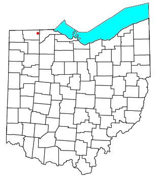
in southern Amboy Township
Amboy Township, Fulton County, Ohio
Amboy Township is one of the twelve townships of Fulton County, Ohio, United States. The 2000 census found 1,552 people in the township, 989 of whom lived in the unincorporated portions of the township.-Geography:...
, Fulton County
Fulton County, Ohio
Fulton County is a county located in the U.S. state of Ohio. As of 2010, the population was 42,698. Its county seat is Wauseon. Fulton County is named for Robert Fulton, inventor of the steamboat....
, Ohio
Ohio
Ohio is a Midwestern state in the United States. The 34th largest state by area in the U.S.,it is the 7th‑most populous with over 11.5 million residents, containing several major American cities and seven metropolitan areas with populations of 500,000 or more.The state's capital is Columbus...
, United States
United States
The United States of America is a federal constitutional republic comprising fifty states and a federal district...
. A part of the Toledo Metropolitan Area
Toledo metropolitan area
The Toledo Metropolitan Area is a metropolitan area centered in the American city of Toledo, Ohio. As of the 2010 census, the MSA had a population of 651,429.According to the U.S...
, it lies seven miles from the northern edge of Swanton
Swanton, Ohio
Swanton is a village in Fulton and Lucas counties in the U.S. state of Ohio. The population was 3,690 at the 2010 census.-History:A.D. Baker, a steam engine inventor, ran a machine shop in Swanton from 1901 to 1953.-Geography:...
. It is located at precisely 41°40'N, 83°55'W.
History
Assumption was originally named St. Mary's Corners because it was the location of St. Mary's Catholic Church. In 1840, the area was called both Caraghar's Corners and Caraghar, after an early IrishIreland
Ireland is an island to the northwest of continental Europe. It is the third-largest island in Europe and the twentieth-largest island on Earth...
settler of the area named Patrick Caraghar. By 1942, the village assumed its current name.