

Arthur's Pass National Park
Encyclopedia
South Island
The South Island is the larger of the two major islands of New Zealand, the other being the more populous North Island. It is bordered to the north by Cook Strait, to the west by the Tasman Sea, to the south and east by the Pacific Ocean...
of New Zealand
New Zealand
New Zealand is an island country in the south-western Pacific Ocean comprising two main landmasses and numerous smaller islands. The country is situated some east of Australia across the Tasman Sea, and roughly south of the Pacific island nations of New Caledonia, Fiji, and Tonga...
.
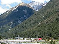
It was established in 1929, becoming the first national park in the South Island and the third in New Zealand. It is bisected by State Highway 73
New Zealand State Highway network
The New Zealand State Highway network is the major national highway network in New Zealand. Just under 100 roads in both the North and South Islands are State Highways...
. The road passes through Arthur's Pass
Arthur's Pass
Arthur's Pass is a mountain pass in the Southern Alps of the South Island of New Zealand. It marks part of the boundary between the West Coast and Canterbury regions, 140 km from Christchurch and 95 km from Greymouth. The pass lies in a saddle between the valleys of the Otira River, a...
village and the mountain pass with the same name over the Southern Alps
Southern Alps
The Southern Alps is a mountain range extending along much of the length of New Zealand's South Island, reaching its greatest elevations near the island's western side...
at a height of 920 metres above sea level. The park is administered by the Department of Conservation
New Zealand Department of Conservation
The Department of Conservation , commonly known by its acronym, "DOC", is the state sector organisation which deals with the conservation of New Zealand’s natural and historic heritage...
and operate a depot, administration and information centre in Arthur's Pass village.
Geography
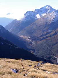
The park is very distinctly split by the main divide of the South Island. The eastern side is typically drier and consists of beech forest and wide riverbeds, while the western side contains dense rainforest. Much of the geography was formed by ancient glacial action, forming flat bottomed U shaped valleys. In the middle is a high range, consisting of large snow covered peaks and scree slopes.The park contains the following geographical features:
- A portion of the main divide of the South Island, including the following passes - Harman, Waimakariri Col, Arthur'sArthur's PassArthur's Pass is a mountain pass in the Southern Alps of the South Island of New Zealand. It marks part of the boundary between the West Coast and Canterbury regions, 140 km from Christchurch and 95 km from Greymouth. The pass lies in a saddle between the valleys of the Otira River, a...
itself, Goat (on the Mingha-Deception route), Tarahuna, Worsley, Minchin and Harper. - The source of the Waimakariri RiverWaimakariri RiverThe Waimakariri River is the largest of the North Canterbury rivers, in the South Island of New Zealand. It flows for 151 kilometres in a generally southeastward direction from the Southern Alps across the Canterbury Plains to the Pacific Ocean....
, very close the Waimakariri Falls Hut. - Numerous tributariesTributaryA tributary or affluent is a stream or river that flows into a main stem river or a lake. A tributary does not flow directly into a sea or ocean...
to the Waimakariri RiverWaimakariri RiverThe Waimakariri River is the largest of the North Canterbury rivers, in the South Island of New Zealand. It flows for 151 kilometres in a generally southeastward direction from the Southern Alps across the Canterbury Plains to the Pacific Ocean....
, including the BealeyBealey RiverThe Bealey River is a small river located in the Southern Alps of New Zealand. It is a tributary of the Waimakariri River. Its valley forms the eastern approach to Arthur's Pass...
, PoulterPoulter RiverThe Poulter River is a river of the Canterbury Region of New Zealand's South Island. The Poulter rises on the southern slopes of Mount Koeti in Arthur's Pass National Park, flowing predominantly southwest to reach the Waimakariri River 15 kilometres to the east of Cass.-References:...
, HawdonHawdon RiverThe Hawdon River is a river of New Zealand. One of the headwaters of Canterbury's Waimakariri River, it flows south through Arthur's Pass National Park, reaching the Waimakariri to the north of the settlement of Cass....
, WhiteWhite River, New ZealandThe White River is in the South Island of New Zealand.It drains from the eastern flanks of the Southern Alps into the Waimakariri River. It is accessible by getting to Klondike Corner on State Highway 73, following the Waimakariri up to Carrington Hut, and turning west...
, Crow and Anti CrowAnti Crow RiverThe Anti Crow River is a small river located in Arthur's Pass National Park, Canterbury, New Zealand. It is a tributary of the Waimakariri River and is named because its valley is opposite that of the Crow River.-References:* - Search for Place Names...
Rivers. - Numerous tributariesTributaryA tributary or affluent is a stream or river that flows into a main stem river or a lake. A tributary does not flow directly into a sea or ocean...
to the Taramakau RiverTaramakau RiverThe Taramakau River is in the northwest of the South Island of New Zealand. It rises in the Southern Alps, 80 kilometres due east of Hokitika, and immediately below the saddle of the Harper's Pass, and runs westward for 75 kilometres into the Tasman Sea 15 kilometres south of Greymouth.Several...
, including the OtiraOtira RiverThe Otira River is located in the central South Island of New Zealand. It rises on the slopes of Mount Rolleston in the Southern Alps, and flows north for 20 km, passing through the town of Otira before joining the Taramakau River...
, DeceptionDeception RiverThe Deception River is a river in New Zealand. It is a tributary of the West Coast's Otira River, flowing generally north for 17 kilometres from its source on the slopes of Mount Franklin. It passes close to Goat Pass, which gives access to the Mingha River. Almost the entire length of the river is...
and OtehakeOtehake RiverOtehake River is located on the West Coast of the South Island of New Zealand. It flows northward through the Arthur's Pass National Park and into the Taramakau River.-References:...
Rivers. - Mt Murchison at 2400 m is the highest peak within the park.
Recreation
The park is popular for tramping, skiingSkiing
Skiing is a recreational activity using skis as equipment for traveling over snow. Skis are used in conjunction with boots that connect to the ski with use of a binding....
and mountaineering
Mountaineering
Mountaineering or mountain climbing is the sport, hobby or profession of hiking, skiing, and climbing mountains. While mountaineering began as attempts to reach the highest point of unclimbed mountains it has branched into specialisations that address different aspects of the mountain and consists...
.
Popular tramping tracks include:
- Mingha-Deception, part of the Coast to Coast race
- Avalanche Peak
- Hawdon-Edwards
The local weather conditions can be accessed here.
Park safety
Arthur's Pass National Park has an unfortunate reputation as one of the most dangerous national parks in New Zealand. In the first three months of 2006 alone two people died whilst walking in the park. Whilst no formal studies have been conducted, amongst the tramping community and the permanent Arthur's Pass community it is felt that the combination of harsh alpine terrain and easy accessibility combine to contribute to the high death and injury rate.The mountains around Arthur's Pass contain some very challenging terrain. The marked day walks in the park, all easily accessible from the Arthur's Pass village carparks, involve vertical ascents of around 1000 metres (3000 feet) and include several hours well above the tree line. The peaks are highly exposed to the weather, the tracks are often very steep (steep enough to require the walker to pull themselves up with their hands in some places) and are often marked only by poles strung across a rocky landscape. Below the tree line the bush is dense and thick. In common with many alpine areas the weather is subject to frequent and sudden change. There are frequent bluffs and cliffs and most creeks running down the mountains tumble over waterfalls in one place or another. Further, there are a number of harder routes within the park that require a high level of mountaineering skill and the use of ropes and other such equipment. In short, safely traversing the terrain requires at least a moderate level of experience, knowledge and equipment as it is true 'back country'.
Arthur's Pass National Park is also within a few hour's driving time of Christchurch, the largest city in the South Island of New Zealand. This easy access for visitors to New Zealand, as well as the immediate access to the mountain trails from the village (unlike many other parts of the Alps where getting to the mountains requires a day or more tramp over more gentle terrain, which tends to dissuade the less prepared tramper) appears to lead to larger numbers of unprepared persons overstepping their abilities and getting into mortal peril. The most common scenarios are: persons caught above the tree line in bad weather with insufficient clothing and/or food then suffer from hypothermia
Hypothermia
Hypothermia is a condition in which core temperature drops below the required temperature for normal metabolism and body functions which is defined as . Body temperature is usually maintained near a constant level of through biologic homeostasis or thermoregulation...
; persons attempt a climb that requires knowledge or equipment they do not possess and often become stuck on a ledge or cliff, unable to climb back or continue on due to the steepness of the terrain, often then facing the problems of bad weather/hypothermia; persons attempt a climb that requires knowledge or equipment they do not possess and attempt a manoeuvre that result in a serious or fatal fall; persons become lost or disoriented, often due to change of weather, lose the trail or attempt to take a shortcut and suffer a serious or fatal fall.