
Arrochar, Scotland
Encyclopedia
Arrochar is a village located near the head of Loch Long
in Argyll and Bute
, Scotland
.
It is overlooked by a group of mountains called the Arrochar Alps
, and in particular by the distinctive rocky summit of The Cobbler
. It enjoys good communications as it is at the junction of the A83
and A814 roads and is served by Arrochar and Tarbet railway station
. In addition the A82 road
runs through Tarbet two miles to the east.
For over five centuries this area, the feudal barony of Arrochar, was held by the chiefs of Clan MacFarlane
and before them by their ancestors the barons of Arrochar.
The family is Celtic in the male line and native to their Highland homeland of tall peaks and deep lochs just above the waist of Scotland.
The settlement was a key target for Viking raiders who took their boats 2 miles overland to Tarbet to attack the unprotected inland settlements at Loch Lomond before their defeat in 1263 at the battle of Largs
.
The western end of Arrochar marks the traditional boundary of Argyllshire and Dunbartonshire
, and this remained the case under local government reorganisation in 1975. However in 1996 the boundaries of Argyll and Bute and West Dunbartonshire
were substantially redrawn, bringing the whole area into Argyll and Bute.
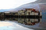
nov2007.jpg) The photograph shows the former torpedo
The photograph shows the former torpedo
testing facility at the head of Loch Long
. It was decommissioned in 1980 and is currently part demolished. Demolition has been stalled since a fire on the site in June 2007.
Torpedoes were fired up Loch Long from tubes at the front of the facility. A boat stood by to recover the (unarmed) torpedoes where they were returned for analysis. The now roofless shed to the left and the main part of the building have tracks where torpedoes were stored and worked on. Hoists on the first floor lowered the torpedoes into the tubes.
The control room at the top looking straight down the loch housed a camera. Behind the control room, above the loading shed, is office accommodation. The rest of the facility included housing and workshops but these have been sold off.
Loch Long
Loch Long is a body of water in Argyll and Bute, Scotland. The sea loch extends from the Firth of Clyde at its southwestern end. It measures approximately 20 miles in length, with a width of between one and two miles...
in Argyll and Bute
Argyll and Bute
Argyll and Bute is both one of 32 unitary council areas; and a Lieutenancy area in Scotland. The administrative centre for the council area is located in Lochgilphead.Argyll and Bute covers the second largest administrative area of any Scottish council...
, Scotland
Scotland
Scotland is a country that is part of the United Kingdom. Occupying the northern third of the island of Great Britain, it shares a border with England to the south and is bounded by the North Sea to the east, the Atlantic Ocean to the north and west, and the North Channel and Irish Sea to the...
.
It is overlooked by a group of mountains called the Arrochar Alps
Arrochar Alps
The Arrochar Alps are a group of mountains located around the head of Loch Long, Loch Fyne,and Loch Goil, near the villages of Arrochar and Lochgoilhead in Argyll, Scotland. The mountains are especially popular with hillwalkers, due to their proximity and accessibility from Glasgow...
, and in particular by the distinctive rocky summit of The Cobbler
The Cobbler
The Cobbler is a mountain of 884 m height located near the head of Loch Long in Scotland. It is a Corbett...
. It enjoys good communications as it is at the junction of the A83
A83 road
The A83 is a major road in Argyll and Bute, Scotland, running from Tarbet, on the western shore of Loch Lomond, where it splits from the A82, to Campbeltown at the southern end of the Kintyre peninsula.-Route:...
and A814 roads and is served by Arrochar and Tarbet railway station
Arrochar and Tarbet railway station
Arrochar and Tarbet railway station is a railway station on the West Highland Line in Scotland. It stands between the villages of Arrochar and Tarbet.- History :...
. In addition the A82 road
A82 road
The A82 is a trunk road in Scotland. It is the principal route from Lowland Scotland to the western Scottish Highlands, running from Glasgow to Inverness, going by Loch Lomond, Glen Coe and Fort William. It is the second longest primary A-road in Scotland after the A9, which is the other...
runs through Tarbet two miles to the east.
For over five centuries this area, the feudal barony of Arrochar, was held by the chiefs of Clan MacFarlane
Clan MacFarlane
Clan MacFarlane is a Highland Scottish clan. The clan claims a descent from the old line of the Earls of Lennox. For some time there had been some controversy as to the descent of these earls, with both Gaelic and Anglo-Saxon origins given. Though today it is accepted that Clan MacFarlane is of...
and before them by their ancestors the barons of Arrochar.
The family is Celtic in the male line and native to their Highland homeland of tall peaks and deep lochs just above the waist of Scotland.
The settlement was a key target for Viking raiders who took their boats 2 miles overland to Tarbet to attack the unprotected inland settlements at Loch Lomond before their defeat in 1263 at the battle of Largs
Battle of Largs
The Battle of Largs was an engagement fought between the armies of Norway and Scotland near the present-day town of Largs in North Ayrshire on the Firth of Clyde in Scotland on 2 October 1263. It was the most important military engagement of the Scottish-Norwegian War. The Norwegian forces were...
.
The western end of Arrochar marks the traditional boundary of Argyllshire and Dunbartonshire
Dunbartonshire
Dunbartonshire or the County of Dumbarton is a lieutenancy area and registration county in the west central Lowlands of Scotland lying to the north of the River Clyde. Until 1975 it was a county used as a primary unit of local government with its county town and administrative centre at the town...
, and this remained the case under local government reorganisation in 1975. However in 1996 the boundaries of Argyll and Bute and West Dunbartonshire
West Dunbartonshire
West Dunbartonshire is one of the 32 local government council areas of Scotland. Bordering onto the west of the City of Glasgow, containing many of Glasgow's commuter towns and villages as well as the city's suburbs, West Dunbartonshire also borders onto Argyll and Bute, Stirling, East...
were substantially redrawn, bringing the whole area into Argyll and Bute.
Arrochar Torpedo Testing Facility
Torpedo
The modern torpedo is a self-propelled missile weapon with an explosive warhead, launched above or below the water surface, propelled underwater towards a target, and designed to detonate either on contact with it or in proximity to it.The term torpedo was originally employed for...
testing facility at the head of Loch Long
Loch Long
Loch Long is a body of water in Argyll and Bute, Scotland. The sea loch extends from the Firth of Clyde at its southwestern end. It measures approximately 20 miles in length, with a width of between one and two miles...
. It was decommissioned in 1980 and is currently part demolished. Demolition has been stalled since a fire on the site in June 2007.
Torpedoes were fired up Loch Long from tubes at the front of the facility. A boat stood by to recover the (unarmed) torpedoes where they were returned for analysis. The now roofless shed to the left and the main part of the building have tracks where torpedoes were stored and worked on. Hoists on the first floor lowered the torpedoes into the tubes.
The control room at the top looking straight down the loch housed a camera. Behind the control room, above the loading shed, is office accommodation. The rest of the facility included housing and workshops but these have been sold off.