
Arizona State Route 289
Encyclopedia
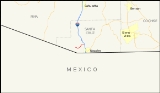
State Route 289 is a highway in Santa Cruz County, Arizona
that runs from its junction with Interstate 19, old U.S. Route 89 to the north of Nogales
to Peña Blanca Lake
. It is an east–west route.
and continues west to the town of Arivaca and SR 286
. This stretch requires four-wheel drive and there are no services along the entire stretch.
.
Santa Cruz County, Arizona
-2010:Whereas according to the 2010 U.S. Census Bureau:*73.5% White*0.4% Black*0.7% Native American*0.5% Asian*0.0% Native Hawaiian or Pacific Islander*2.0% Two or more races*22.9% Other races*82.8% Hispanic or Latino -2000:...
that runs from its junction with Interstate 19, old U.S. Route 89 to the north of Nogales
Nogales, Arizona
Nogales is a city in Santa Cruz County, Arizona, United States. The population was 21,017 at the 2010 census. According to 2005 Census Bureau estimates, the population of the city is 20,833. The city is the county seat of Santa Cruz County....
to Peña Blanca Lake
Peña Blanca Lake
Peña Blanca Lake is a reservoir in Arizona, United States, located northwest of Nogales. The facilities are maintained by the Coronado National Forest division of the USDA Forest Service....
. It is an east–west route.
Route description
SR 289 is a 10.33 miles (16.62 km) highway that runs from I-19 westward to the Pena Blanca Dam, passing through sparsely inhabited territory. It does not pass through any cities or towns and primarily serves as access for recreation at Pena Blanca Lake. From its eastern terminus at I-19, the highway heads in a western direction before curving towards the southwest. The highway eventually curves back towards the west until it turns north towards the lake. There is a Y junction where the road branches off to the lake to the north and a forest road that continues west that connects to a very scenic drive through the Coronado National Forest. This road passes Arivaca Peak, Sycamore Canyon, the ghost town of RubyRuby, Arizona
Ruby is a ghost town in Santa Cruz County, Arizona, United States. It was founded as a mining town in Bear Valley, originally named Montana Camp, so named because the miners were mining at the foot of Montana Peak.-History:...
and continues west to the town of Arivaca and SR 286
Arizona State Route 286
State Route 286 is a highway in southern Arizona that runs from its junction with State Route 86 west of Tucson to the US-Mexico border at Sasabe. It is largely a north–south route.-Route description:...
. This stretch requires four-wheel drive and there are no services along the entire stretch.
Junction list
The entire route is in Santa Cruz CountySanta Cruz County, Arizona
-2010:Whereas according to the 2010 U.S. Census Bureau:*73.5% White*0.4% Black*0.7% Native American*0.5% Asian*0.0% Native Hawaiian or Pacific Islander*2.0% Two or more races*22.9% Other races*82.8% Hispanic or Latino -2000:...
.
| Mile | Junction | Notes |
|---|---|---|
| 0.00 | ||
| 10.33 | Peña Blanca Dam |