
Arghandab District
Encyclopedia
Arghandab is a district
in the central part of Kandahar Province
, Afghanistan
. It borders Panjwai and Khakrez
districts to the west, Shah Wali Kot District
to the north and east and Kandahar District
to the east and south.
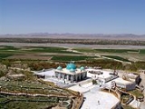
The population, as of 2006, was 54,900. The district centre is Arghandab
, located northwest of Kandahar
. The Arghandab River
flows through the district in its eastern part West from the district center. The climate and the river allow the inhabitants to grow orchards, producing a variety of fruits. The district was the site of a battle
in June 2008.
On 9 June 2010, a suicide attack at a wedding party in the village of Nagahan of the Arghandab district killed at least 40 people and wounded 77, making it one of the worst attacks of the year.
District
Districts are a type of administrative division, in some countries managed by a local government. They vary greatly in size, spanning entire regions or counties, several municipalities, or subdivisions of municipalities.-Austria:...
in the central part of Kandahar Province
Kandahar Province
Kandahar or Qandahar is one of the largest of the thirty-four provinces of Afghanistan. It is located in southern Afghanistan, between Helmand, Oruzgan and Zabul provinces. Its capital is the city of Kandahar, which is located on the Arghandab River. The province has a population of nearly...
, Afghanistan
Afghanistan
Afghanistan , officially the Islamic Republic of Afghanistan, is a landlocked country located in the centre of Asia, forming South Asia, Central Asia and the Middle East. With a population of about 29 million, it has an area of , making it the 42nd most populous and 41st largest nation in the world...
. It borders Panjwai and Khakrez
Khakrez District
Khakrez District is situated in the northern part of Kandahar Province, Afghanistan. It borders Ghorak District to the west, Maywand and Panjwai districts to the south, Arghandab and Shah Wali Kot districts to the east and Naish District to the north. The population is 20,200...
districts to the west, Shah Wali Kot District
Shah Wali Kot District
Shah Wali Kot District is situated in the northern part of Kandahar Province, Afghanistan. It borders Khakrez District to the west, Naish District and Oruzgan Province to the north, Zabul Province to the east and Daman and Arghandab districts to the south. The population is 38,400 . The district...
to the north and east and Kandahar District
Kandahar District
Kandahar District is situated in the central part of Kandahar Province, Afghanistan, surrounding the city of Kandahar. It borders with Panjwai District to the west, Arghandab District to the north, Shah Wali Kot District to the northeast and Daman District to the east and south. The population is...
to the east and south.
The population, as of 2006, was 54,900. The district centre is Arghandab
Arghandab, Afghanistan
The town of Arghandab is the center of Arghandab District in Kandahar Province, Afghanistan in the valley of Arghandab River northwest from Kandahar. It is located on at an elevation of ....
, located northwest of Kandahar
Kandahar
Kandahar is the second largest city in Afghanistan, with a population of about 512,200 as of 2011. It is the capital of Kandahar Province, located in the south of the country at about 1,005 m above sea level...
. The Arghandab River
Arghandab River
Arghandab is a river in Afghanistan, about in length. It rises in the Hazarajat country north-west of Ghazni, and flows south-west falls into the Helmand below Girishk. In its lower course it is much used for irrigation, and the valley is cultivated and populous; yet the water is said to be...
flows through the district in its eastern part West from the district center. The climate and the river allow the inhabitants to grow orchards, producing a variety of fruits. The district was the site of a battle
Battle of Arghandab
The Battle of Arghandab began on June 18, 2008, when NATO-led forces attacked Taliban militants in response to Taliban attacks in Arghandab District and Kandahar...
in June 2008.
Attacks
On 16 November 2009, Taliban attackers raided a police station, killing eight officers and wounding three. Three other police officers in the station disappeared, and a spokesman for the Kandahar governor’s office, who asked not to be identified by name, said he was not sure if the officers who disappeared had a connection to the Taliban.On 9 June 2010, a suicide attack at a wedding party in the village of Nagahan of the Arghandab district killed at least 40 people and wounded 77, making it one of the worst attacks of the year.