
Araçoiaba da Serra
Encyclopedia
| Coat of arms | |
|---|---|
 |
|
| Statistics | |
| State: | São Paulo São Paulo (state) São Paulo is a state in Brazil. It is the major industrial and economic powerhouse of the Brazilian economy. Named after Saint Paul, São Paulo has the largest population, industrial complex, and economic production in the country. It is the richest state in Brazil... |
| Meso-region: | Paulista Macro-Metropolitan Meso-Region |
| Microrregions: | Sorocaba Sorocaba (micro-region) The Microregion of Sorocaba is a microregion in the central part of São Paulo State, Brazil.- Municipalities:* Alumínio* Araçariguama* Araçoiaba da Serra* Cabreúva* Capela do Alto* Iperó* Itu* Mairinque* Porto Feliz* Salto* Salto de Pirapora... |
| Location Location (geography) The terms location and place in geography are used to identify a point or an area on the Earth's surface or elsewhere. The term 'location' generally implies a higher degree of can certainty than "place" which often has an ambiguous boundary relying more on human/social attributes of place identity... : |
23.525/23°30'19" S, 47.6145/47°36'51" W |
| Area Area Area is a quantity that expresses the extent of a two-dimensional surface or shape in the plane. Area can be understood as the amount of material with a given thickness that would be necessary to fashion a model of the shape, or the amount of paint necessary to cover the surface with a single coat... : |
256.15 km² |
| Population Population A population is all the organisms that both belong to the same group or species and live in the same geographical area. The area that is used to define a sexual population is such that inter-breeding is possible between any pair within the area and more probable than cross-breeding with individuals... : |
22,521(2004) Ranked 312nd |
| Population density Population density Population density is a measurement of population per unit area or unit volume. It is frequently applied to living organisms, and particularly to humans... : |
247.97/km² |
| Elevation Elevation The elevation of a geographic location is its height above a fixed reference point, most commonly a reference geoid, a mathematical model of the Earth's sea level as an equipotential gravitational surface .... : |
625 m |
| Area/distance code: | (00)55-15 |
| Website: | http://www.aracoiaba.sp.gov.br |
| Population Statistics | |
| Urban: | 13,679 |
| Rural: | 6,137 |
| Other | |
| Literacy rate: | 92.14% |
| Distance from the state capital: | N/A |
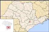
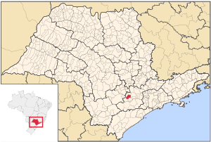
Araçoiaba da Serra is a city in the state of São Paulo
São Paulo (state)
São Paulo is a state in Brazil. It is the major industrial and economic powerhouse of the Brazilian economy. Named after Saint Paul, São Paulo has the largest population, industrial complex, and economic production in the country. It is the richest state in Brazil...
in Brazil
Brazil
Brazil , officially the Federative Republic of Brazil , is the largest country in South America. It is the world's fifth largest country, both by geographical area and by population with over 192 million people...
. The population in 2004 is 22,521 and the area is 256.15 km². The elevation is 625 m. The first part of the origin of the name comes from the Tupi language, meaning "hider of the sun." This name comes from a single mountain nearby that the natives noted hid the sun as it set in the area.
Population history
| Year | Population | Change | Density |
|---|---|---|---|
| 2001 | 19,816 | - | 76.24/km² |
| 2004 | 22,521 | - | 139.41/km² |
Demographics
According to the 2000 IBGEIBGE
The Brazilian Institute of Geography and Statistics or IBGE , is the agency responsible for statistical, geographic, cartographic, geodetic and environmental information in Brazil...
Census, the population was 19,816, of which 13,679 are urban and 6,137 are rural. Its life expectancy for the city was 71.1 years. The literacy rate was at 92.14%.