

Antoine-Labelle Regional County Municipality, Quebec
Encyclopedia
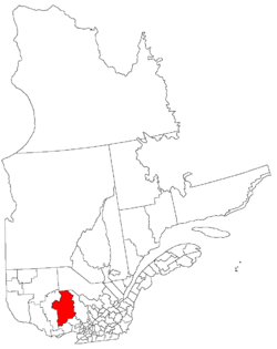
Quebec
Quebec or is a province in east-central Canada. It is the only Canadian province with a predominantly French-speaking population and the only one whose sole official language is French at the provincial level....
, Canada, in the Laurentides
Laurentides (region)
The Laurentides is a region of Quebec. While it is often called the Laurentians in English, the region includes only part of the Laurentian mountains...
region. The Regional County Municipality seat is Mont-Laurier
Mont-Laurier, Quebec
Mont-Laurier is a town and incorporated municipality in northwest Quebec, Canada, located on the banks of the Rivière du Lièvre, a tributary of the Ottawa River. Known as the “Capital of the Haute-Laurentides”, the motto of the town is Laurus elationis praemium, which translates to “Lift the...
.
Municipalities
- Chute-Saint-PhilippeChute-Saint-Philippe, QuebecChute-Saint-Philippe is a municipality in the Laurentides region of Quebec, Canada, part of the Antoine-Labelle Regional County Municipality.The village is located in a fairly flat valley surrounded by a mountainous area of the Laurentian Hills that are dominated by mixed forest.-History:The...
- Ferme-NeuveFerme-Neuve, QuebecFerme-Neuve is a municipality in the Laurentides region of Quebec, Canada, part of the Antoine-Labelle Regional County Municipality...
- KiamikaKiamika, QuebecKiamika is a municipality in the Laurentides region of Quebec, Canada, part of the Antoine-Labelle Regional County Municipality.Joseph Montferrand , a logger of imposing stature and extraordinary physical strength, was from Kiamika.-Etymology:...
- La MacazaLa Macaza, QuebecLa Macaza is a municipality and village in the province of Quebec, Canada. The village is located in the Laurentian Mountains, in the Laurentian region, in Antoine-Labelle Regional County Municipality. In 2008 it had a population of 975....
- Lac-des-ÉcorcesLac-des-Écorces, QuebecLac-des-Écorces is a municipality and village in the Laurentides region of Quebec, Canada, part of the Antoine-Labelle Regional County Municipality.It is named after Bark Lake that is on its western boundary.-History:...
- Lac-du-CerfLac-du-Cerf, QuebecLac-du-Cerf is a municipality in the Laurentides region of Quebec, Canada, part of the Antoine-Labelle Regional County Municipality. It is located on and named after Lac du Cerf .-Demographics:Population:* Population in 2006: 424...
- Lac-Saint-PaulLac-Saint-Paul, QuebecLac-Saint-Paul is a municipality in the Laurentides region of Quebec, Canada, part of the Antoine-Labelle Regional County Municipality.-Demographics:Population:* Population in 2006: 521 * Population in 2001: 429...
- L'AscensionL'Ascension, QuebecL'Ascension is a municipality in the Laurentides region of Quebec, Canada, part of the Antoine-Labelle Regional County Municipality.-Demographics:Population:* Population in 2006: 861 * Population in 2001: 783...
- Mont-Saint-MichelMont-Saint-Michel, QuebecMont-Saint-Michel is a municipality in the Laurentides region of Quebec, Canada, part of the Antoine-Labelle Regional County Municipality.-Demographics:Population:* Population in 2006: 625 * Population in 2001: 619...
- Nominingue
- Notre-Dame-de-PontmainNotre-Dame-de-Pontmain, QuebecNotre-Dame-de-Pontmain is a municipality in the Laurentides region of Quebec, Canada, part of the Antoine-Labelle Regional County Municipality.The village itself is located between Camp and Dudley Lakes in the Du Lièvre River watershed.-History:...
- Notre-Dame-du-LausNotre-Dame-du-Laus, QuebecNotre-Dame-du-Laus is a municipality in the Laurentides region of Quebec, Canada, part of the Antoine-Labelle Regional County Municipality.The municipality is characterized by hilly forests with a great number of lakes, rivers, and creeks. The eastern portion of its territory is part of the...
- Saint-Aimé-du-Lac-des-ÎlesSaint-Aimé-du-Lac-des-Îles, QuebecSaint-Aimé-du-Lac-des-Îles is a municipality in the Laurentides region of Quebec, Canada, part of the Antoine-Labelle Regional County Municipality....
- Sainte-Anne-du-LacSainte-Anne-du-Lac, Laurentides, QuebecSainte-Anne-du-Lac is a municipality and village in the Laurentides region of Quebec, Canada, part of the Antoine-Labelle Regional County Municipality.Sainte-Anne-du-Lac is the northern-most place in the Laurentides region, about from Mont-Laurier...
Non-organized Territories
- Baie-des-ChaloupesBaie-des-Chaloupes, QuebecBaie-des-Chaloupes is an unorganized territory of Quebec located in the regional county municipality of Antoine-Labelle. It covers an area of 900 km.-Demographics:Population:* Population in 2006: 0* Population in 2001: 0* Population in 1996: 0...
- Lac-Akonapwehikan
- Lac-Bazinet
- Lac-De La Bidière
- Lac-de-la-Maison-de-Pierre
- Lac-de-la-Pomme
- Lac-DouaireLac-Douaire, QuebecLac-Douaire is an unorganized territory of Quebec, Canada. It is the largest geo-political division in the Laurentides region, and one of eleven unorganized areas in the Antoine-Labelle Regional County Municipality.-Demographics:Population:...
- Lac-ErnestLac-Ernest, QuebecLac-Ernest is an unorganized territory in the Laurentides region of Quebec, Canada. It is almost entirely within the Papineau-Labelle Wildlife Reserve.-History:...
- Lac-MargueriteLac-Marguerite, QuebecLac-Marguerite is one of eleven unorganized territories in the Laurentides region of Quebec, Canada.-Demographics:Population:* Population in 2006: 0* Population in 2001: 0* Population in 1996: 0* Population in 1991: 0-References:...
- Lac-Oscar
- Lac-Wagwabika
Highways
Highways that run through Antoine-Labelle are as follows:- Primary Highways: Quebec Route 107Quebec route 107Route 107 is a north/south highway on the north shore of the Saint Lawrence River. Its southern terminus is in Maniwaki at the junction of Route 105 and its northern terminus is in Grand-Remous at the junction of Route 117...
, Quebec Route 117Quebec route 117Route 117 is a provincial highway within the Canadian province of Quebec, running between Montreal and the Quebec/Ontario border where it continues as Highway 66 east of Kearns, Ontario...
(Trans-Canada HighwayTrans-Canada HighwayThe Trans-Canada Highway is a federal-provincial highway system that joins the ten provinces of Canada. It is, along with the Trans-Siberian Highway and Australia's Highway 1, one of the world's longest national highways, with the main route spanning 8,030 km...
) - Secondary Highways: Quebec Route 309Quebec Route 309Route 309 is a provincial highway located in the Outaouais region in western Quebec. It starts at the junction of Autoroute 50 in the Buckingham sector, in the city of Gatineau's east end...
, Quebec Route 311Quebec Route 311Route 311 is a provincial highway located in the Laurentides region of Quebec. The 77 kilometer-highway runs from south to north from the junction of Route 309 in Notre-Dame-de-Pontmain to Mont-Saint-Michel also at the junction of Highway 309...
, Quebec Route 321Quebec route 321Route 321 is a regional road in Papineau Regional County Municipality, Quebec, Canada, that runs from Papineauville to Duhamel.The portion north of Chénéville is still unmarked on some maps, but it is signed on the road, and is very sinuous. On most of the Chénéville-Duhamel part, it is impossible...
Airports
- Rivière-Rouge/Mont-Tremblant International AirportRivière Rouge/Mont-Tremblant International Inc AirportLa Macaza – Mont Tremblant International Airport , commonly Mont-Tremblant International and formerly Rivière Rouge – Mont Tremblant International Airport, is a single runway airport located in the township of La Macaza, about north of Mont-Tremblant, Quebec, Canada.-Military Base:The airport was...
(La Macaza) - Aéroport de Mont-LaurierMont-Laurier AirportMont-Laurier Airport, , is located west of Mont-Laurier, Quebec, Canada.-External links:* on COPA's Places to Fly airport directory...
(Mont-Laurier) - Hydrobase Ste-Véronique (Rivière-Rouge, secteur Sainte-Véronique)
Protected Areas
- Mont-Tremblant National ParkMont-Tremblant National ParkMont-Tremblant National Park is a 1,510.10 km² provincial park located north of the town of Mont-Tremblant, Quebec, and the village of Saint-Donat and Saint-Côme...
- Information Centers/ Camp Areas:
- Lac Cache
- Post d'accueil de la Cache
- Information Centers/ Camp Areas:
- Papineau-Labelle Wildlife ReservePapineau-Labelle Wildlife ReservePapineau-Labelle Wildlife Reserve is a reserve in the Laurentian Mountains of Quebec, Canada, stretching across the Laurentides and Outaouais regions.The area was extensively logged in the late 19th to the mid 20th century...
- Information Centers/ Camp Areas:
- Accueil Pie IX
- Benjamin
- Camp de gardien
- Camp du gardien (on Lac Joinville)
- Camp du gardien (on Lac Ernest)
- Caragana
- Corbeau
- De l'Averse
- De l'Hote
- Desaulniers
- Du Sourd
- Entree Benjamin
- Entree Corbeau
- Entree Du Sourd
- Entree Louvigny
- Fascinant
- Flood
- Heron
- Lac-du-Sourd
- Lac-Ernest
- Lac-Joinville
- Lagace
- Leclerc
- Le Mesange/Vieux Foyer
- Letourneau
- Quatre-Temps
- Sept Freres
- Tarte
- Travers
- Wisik/Calliergon/Trille
- Information Centers/ Camp Areas:
- Rouge-Matawin Wildlife Reserve
- Information Centers/ Camp Areas:
- Entree de La Macaza
- Poste d'accueil de La Macaza
- Poste d'accueil de l'Ascension
- Information Centers/ Camp Areas:
- Zones d'exploitation contrôléeZECA ZEC is a "Controlled harvesting zone". ZECs are a system of territorial infrastructures set up in 1978 by the Government of Quebec to take over from private hunting and fishing clubs...
:- ZEC Le Sueur
- ZEC Mitchinamecus
- ZEC Normandie
- ZEC Petawaga
Attractions
- Armand-Lachaine Covered Bridge [1906] (Chute-Saint-Philippe)
- Exposition de Mont-Laurier Centre (Mont-Laurier)
- Ferme-Rouge Covered Bridge [1903] (Kiamika/Saint-Aimé-du-Lac-des-Îles)
- La Gare Centre of Exposition [1903] (L'Annonciation)
- Macaza Covered Bridge [1904] (La Macaza)
- Mont-Laurier Airport (Des Ruisseaux)
- P'tit-train du Nord trail
Demographics
From the Canada 2006 CensusCanada 2006 Census
The Canada 2006 Census was a detailed enumeration of the Canadian population. Census day was May 16, 2006. The next census following will be the 2011 Census. Canada's total population enumerated by the 2006 census was 31,612,897...
:
- Population: 34,999
- Population change (2001-2006): 4.6
- Dwellings: 21,811
- Area (km2): 14,954.44
- Density (per km2.): 2.3
Surrounding Census Divisions
- Les Laurentides Regional County Municipality, QuebecLes Laurentides Regional County Municipality, QuebecLes Laurentides is a Regional County Municipality in southwestern Quebec, Canada, in the Laurentides region. The seat is in Saint-Faustin-Lac-Carré and it is named after the Laurentian Mountains...
- La Vallée-de-la-Gatineau Regional County Municipality, QuebecLa Vallée-de-la-Gatineau Regional County Municipality, QuebecLa Vallée-de-la-Gatineau is a Regional County Municipality in the Outaouais region of western Quebec, Canada. The seat is in Gracefield. It is named for its location straddling the Gatineau River north of Low. It was incorporated on January 1, 1983.It consists of two cities, fifteen...
- La Tuque, QuebecLa Tuque, QuebecLa Tuque is a city in south central Quebec, Canada, on the Saint-Maurice River, between Trois-Rivières and Chambord. In 2006, it had a population of 11,821 Latuquois....
- Matawinie Regional County Municipality, QuebecMatawinie Regional County Municipality, Quebec300px|rightMatawinie is a Regional County Municipality in southwestern Quebec, Canada. Its seat is Rawdon. The population of the MRC according to the 2006 Census is 49,717-Municipalities:*Chertsey*Entrelacs*Notre-Dame-de-la-Merci*Rawdon...
- Papineau Regional County Municipality, QuebecPapineau Regional County Municipality, QuebecPapineau is a county regional municipality of Quebec in Canada located in the Outaouais region. The regional seat is Papineauville.-Communities:*Cities and Towns**Thurso*Municipalities** Boileau** Bowman** Chénéville** Duhamel** Fassett...