ABSOLUTEASTRONOMY
Create a free discussion account!
Signup
Login
x
Home
Search
Topics
Almanac
Science
Nature
People
History
Society
Signup
Login
ABSOLUTEASTRONOMY
HOME
TOPICS
ALMANAC
SCIENCE
NATURE
PEOPLE
HISTORY
SOCIETY
PHILOSOPHY
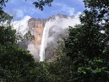
Angel Falls
Topic Home
Discussion
2
Definition
Overview
Unanswered Questions
Who was the first to climb angel falls?
What are the average temperatures at Angel Falls?
More
x
OK