

Amphoe Mueang Mae Hong Son
Encyclopedia
Mae Hong Son Province
Most of the areas of Mae Hong Son Province are complex mountain ranges and likely still pristine virgin forest. Of the approximately 6,976,650 rai of national forest reserves, 88.02% is thought to be pristine virgin forest...
, northern Thailand
Thailand
Thailand , officially the Kingdom of Thailand , formerly known as Siam , is a country located at the centre of the Indochina peninsula and Southeast Asia. It is bordered to the north by Burma and Laos, to the east by Laos and Cambodia, to the south by the Gulf of Thailand and Malaysia, and to the...
.
History
The Interior Ministry upgraded Mueang Mae Hong Son to be a 4th class city under Monthon Phayap on May 10, 1910. It then consisted of the four districts Mueang Mae Hong Son, Mueang Yuam (now Mae Sariang district), Pai and Khun Yuam.In 1917, the district was renamed from Mueang to Muai To (ม่อยต่อ). In 1938 it was renamed to Mueang Mae Hong Son. The north-eastern part of the district was split off in 1987 and formed the new district Pang Mapha.
Geography
Neighboring are (from south clockwise) Khun Yuam of Mae Hong Son Province, Kayah StateKayah State
Kayah State is a state of Myanmar. Situated in eastern Myanmar, it is bounded on the north by Shan State, on the east by Thailand's Mae Hong Son Province, and on the south and west by Kayin State. It lies approximately between 18° 30' and 19° 55' north latitude and between 94°40' and 97° 93' east...
of Myanmar
Myanmar
Burma , officially the Republic of the Union of Myanmar , is a country in Southeast Asia. Burma is bordered by China on the northeast, Laos on the east, Thailand on the southeast, Bangladesh on the west, India on the northwest, the Bay of Bengal to the southwest, and the Andaman Sea on the south....
, Pang Mapha, Pai of Mae Hong Son Province again and Galyani Vadhana
Galyani Vadhana District
Galyani Vadhana is a district of Chiang Mai Province in northern Thailand. It is named after the Princess Galyani Vadhana. It was founded on December 26, 2009, making it the 878th and latest district of Thailand.-History:...
and Mae Chaem of Chiang Mai Province
Chiang Mai Province
Chiang Mai is the second-largest province of Thailand, located in the north of the country. Neighboring provinces are Chiang Rai, Lampang, Lamphun, Tak, and Mae Hong Son. In the north it borders Shan State of Burma...
.
The Namtok Mae Surin National Park office is located in the district.
Administration
The district is subdivided into 7 subdistricts (tambonTambon
Tambon is a local government unit in Thailand. Below district and province , they form the third administrative subdivision level. As of the 2009 there are 7255 tambon, not including the 169 khwaeng of Bangkok, which are set at the same administrative level, thus every district contains 8-10 tambon...
), which are further subdivided into 70 villages (muban
Muban
Muban is the lowest administrative subdivision of Thailand. Usually translated as village, they are the subdivision of tambon. As of 2008, there are 74944 administrative villages in Thailand. As of the 1990 census, the average village consisted of 144 households or 746 persons.A muban does not...
). Mae Hong Son
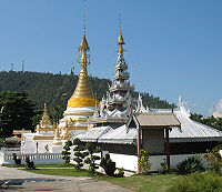
Mae Hong Son
Mae Hong Son ) is a town in north west Thailand, capital of the Mae Hong Son Province. It is located in the Shan Hills, near the border with Burma along the banks of the river Pai...
itself is a town (thesaban mueang) which covers the complete tambon Chong Kham. Each of the other 6 tambon is administrated by a Tambon administrative organization (TAO).
| No. | Name | Thai | Villages | Inh. Population A population is all the organisms that both belong to the same group or species and live in the same geographical area. The area that is used to define a sexual population is such that inter-breeding is possible between any pair within the area and more probable than cross-breeding with individuals... |
|---|---|---|---|---|
| 1. | Chong Kham Chong Kham Chong Kham is a village and tambon of Mueang Mae Hong Son District, in Mae Hong Son Province, Thailand. In 2005 it had a total population of 6,440 people. The tambon contains 2 villages.... |
จองคำ | ||
| 6,534 | ||||
| 2. | Huai Pong Huai Pong Huai Pong is a village and tambon of Mueang Mae Hong Son District, in Mae Hong Son Province, Thailand. In 2005 it had a total population of 7056 people. The tambon contains 15 villages.... |
ห้วยโป่ง | 15 | 6,948 |
| 3. | Pha Bong Pha Bong Pha Bong is a village and tambon of Mueang Mae Hong Son District, in Mae Hong Son Province, Thailand. In 2005 it had a total population of 9874 people. The tambon contains 13 villages.... |
ผาบ่อง | 12 | 9,519 |
| 4. | Pang Mu Pang Mu Pang Mu is a village and tambon of Mueang Mae Hong Son District, in Mae Hong Son Province, Thailand. In 2005 it had a total population of 15,577 people. The tambon contains 14 villages.... |
ปางหมู | 13 | 14,725 |
| 5. | Mok Champae Mok Champae Mok Champae is a village and tambon of Mueang Mae Hong Son District, in Mae Hong Son Province, Thailand. In 2010 it had a population of 6,847 people .-Administration:... |
หมอกจำแป่ | 9 | 6,936 |
| 6. | Huai Pha Huai Pha Huai Pha is a village and tambon of Mueang Mae Hong Son District, in Mae Hong Son Province, Thailand. In 2005 it had a total population of 6249 people. The tambon contains 9 villages.... |
ห้วยผา | 8 | 5,431 |
| 9. | Huai Pu Ling Huai Pu Ling Huai Pu Ling is a village and tambon of Mueang Mae Hong Son District, in Mae Hong Son Province, Thailand. In 2005 it had a total population of 3332 people. The tambon contains 11 villages.... |
ห้วยปูลิง | 11 | 3,240 |
Missing numbers are tambon which now form Pang Mapha district.
See also
External links
- amphoe.com (Thai)