
Amphoe Mueang Chiang Rai
Encyclopedia
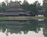
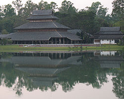
Mueang Chiang Rai is the capital district (amphoe mueang) of Chiang Rai Province
, northern Thailand
.
, Mae Chan
, Wiang Chiang Rung
, Wiang Chai
, Thoeng
, Pa Daet
, Phan
, Mae Lao
, Mae Suai
of Chiang Rai Province and Mae Ai
of Chiang Mai Province
.
The important water resource is the Kok River
.
), which are further subdivided into 256 villages (muban
). The city (thesaban nakhon) Chiang Rai
covers the whole tambon Wiang and parts of Rop Wiang, San Sai and Rum Kok. The township (thesaban tambon) San Sai covers parts of tambon San Sai, and Ban Du the whole tambon Ban Du. There are further 14 Tambon administrative organizations (TAO).
Missing numbers are tambon which now form Mae Lao district.
Chiang Rai Province
Chiang Rai is the northernmost province of Thailand. Neighbouring provinces are Phayao, Lampang and Chiang Mai. In the north it borders Shan State of Myanmar and Bokeo of Laos.-Geography:...
, northern Thailand
Thailand
Thailand , officially the Kingdom of Thailand , formerly known as Siam , is a country located at the centre of the Indochina peninsula and Southeast Asia. It is bordered to the north by Burma and Laos, to the east by Laos and Cambodia, to the south by the Gulf of Thailand and Malaysia, and to the...
.
Geography
Neighboring districts are (from the northwest clockwise) Mae Fa LuangAmphoe Mae Fa Luang
Mae Fa Luang is a district in the northern part of Chiang Rai Province, northern Thailand.-History:The area of Mae Fa Luang was separated from Mae Chan district and created as a minor district on April 1, 1992. Originally it comprised the three tambon Thoet Thai, Mae Salong Nai and Mae Salong Nok...
, Mae Chan
Amphoe Mae Chan
Mae Chan is a district in the northern part of Chiang Rai Province, northern Thailand.-Geography:Neighboring districts are Mae Sai, Chiang Saen, Doi Luang, Mueang Chiang Rai and Mae Fa Luang of Chiang Rai Province....
, Wiang Chiang Rung
Amphoe Wiang Chiang Rung
Wiang Chiang Rung is a district of Chiang Rai Province, northern Thailand.-Geography:Neighboring districts are Mueang Chiang Rai, Doi Luang, Chiang Khong, and Phaya Mengrai and Wiang Chai of Chiang Rai Province....
, Wiang Chai
Amphoe Wiang Chai
Wiang Chai is a district in the central part of Chiang Rai Province, northern Thailand.-Geography:Neighboring districts are Mueang Chiang Rai, Wiang Chiang Rung, Phaya Mengrai and Thoeng of Chiang Rai Province....
, Thoeng
Amphoe Thoeng
Thoeng is a district in the eastern part of Chiang Rai Province, northern Thailand.-Geography:Neighboring districts are Pa Daet, Mueang Chiang Rai, Wiang Chai, Phaya Mengrai, Khun Tan, Wiang Kaen of Chiang Rai Province...
, Pa Daet
Amphoe Pa Daet
Pa Daet is a district in the southern part of Chiang Rai Province, northern Thailand.-History:The area of Pa Daet was originally dense forest of Phan district. People from other places went there to hunt animals and settle new village. It was created as the minor district Pa Daet on June 1 1969,...
, Phan
Amphoe Phan
Phan is a district in the southern part of Chiang Rai Province, northern Thailand.-Geography:Neighboring districts are Wiang Pa Pao, Mae Suai, Mae Lao, Mueang Chiang Rai, Pa Daet of Chiang Rai Province, Mae Chai of Phayao province and Wang Nuea of Lampang Province.-History:Originally named...
, Mae Lao
Amphoe Mae Lao
Mae Lao is a district in the central part of Chiang Rai Province, northern Thailand.-History:The area of Mae Lao district was separated from Mueang Chiang Rai district and established a minor district on May 31, 1993. It originally consisted of the four tambon Dong Mada, Chom Mok Kaeo, Bua Sali...
, Mae Suai
Amphoe Mae Suai
Mae Suai is a district in the western part of Chiang Rai Province, northern Thailand.-Geography:Neighboring districts are Mueang Chiang Rai, Mae Lao, Phan, Wiang Pa Pao, Phrao, Chai Prakan, Fang, Mae Ai of Chiang Mai Province.-History:The district was created in 1905, when the districts Mueang...
of Chiang Rai Province and Mae Ai
Amphoe Mae Ai
Mae Ai is the northernmost district of Chiang Mai Province, northern Thailand.-History:The minor district Mae Ai was created on August 15, 1967, when the three tambon Mae Ai, Mae Sao and Mae Na Wang were separated from Fang district...
of Chiang Mai Province
Chiang Mai Province
Chiang Mai is the second-largest province of Thailand, located in the north of the country. Neighboring provinces are Chiang Rai, Lampang, Lamphun, Tak, and Mae Hong Son. In the north it borders Shan State of Burma...
.
The important water resource is the Kok River
Kok River
The Kok River originates in Shan State, Burma. It flows down and across the Burma-Thailand border to Mae Ai district, Chiang Mai Province, passing under Phahonyothin Road. Most of its length is in Chiang Rai Province passing the districts Mueang Chiang Rai, Mae Chan, Chiang Saen and Wiang Chai. It...
.
Administration
The district is subdivided into 16 subdistricts (tambonTambon
Tambon is a local government unit in Thailand. Below district and province , they form the third administrative subdivision level. As of the 2009 there are 7255 tambon, not including the 169 khwaeng of Bangkok, which are set at the same administrative level, thus every district contains 8-10 tambon...
), which are further subdivided into 256 villages (muban
Muban
Muban is the lowest administrative subdivision of Thailand. Usually translated as village, they are the subdivision of tambon. As of 2008, there are 74944 administrative villages in Thailand. As of the 1990 census, the average village consisted of 144 households or 746 persons.A muban does not...
). The city (thesaban nakhon) Chiang Rai
Chiang Rai
-Demographics:Official Population count: According to the Thailand National Statistical Office, as of September 2010, Chiang Rai municipal district has a population of 199,699...
covers the whole tambon Wiang and parts of Rop Wiang, San Sai and Rum Kok. The township (thesaban tambon) San Sai covers parts of tambon San Sai, and Ban Du the whole tambon Ban Du. There are further 14 Tambon administrative organizations (TAO).
| No. | Name | Thai name | Villages | Inh. Population A population is all the organisms that both belong to the same group or species and live in the same geographical area. The area that is used to define a sexual population is such that inter-breeding is possible between any pair within the area and more probable than cross-breeding with individuals... |
|
|---|---|---|---|---|---|
| 1. | Wiang Wiang, Mueang Chiang Rai Wiang, Mueang Chiang Rai is a tambon of Mueang Chiang Rai District, in Chiang Rai Province, Thailand. In 2005 it had a total population of 12,430 people. The tambon has 5 villages.... |
เวียง | 5 | 12,430 | |
| 2. | Rop Wiang Rop Wiang Rop Wiang is a tambon of Mueang Chiang Rai District, in Chiang Rai Province, Thailand. In 2005 it had a total population of 47,992 people. The tambon has 7 villages.... |
รอบเวียง | 7 | 47,992 | |
| 3. | Ban Du Ban Du Ban Du is a tambon of Mueang Chiang Rai District, in Chiang Rai Province, Thailand. In 2005 it had a total population of 14,542 people. The tambon has 19 villages.... |
บ้านดู่ | 19 | 14,542 | |
| 4. | Nang Lae Nang Lae Nang Lae is a tambon of Mueang Chiang Rai District, in Chiang Rai Province, Thailand. In 2005 it had a total population of 10,312 people. The tambon has 14 villages.... |
นางแล | 14 | 10,312 | |
| 5. | Mae Khao Tom Mae Khao Tom Mae Khao Tom is a tambon of Mueang Chiang Rai District, in Chiang Rai Province, Thailand. In 2005 it had a total population of 12,500 people. The tambon contains 23 villages.... |
แม่ข้าวต้ม | 23 | 12,500 | |
| 6. | Mae Yao Mae Yao Mae Yao is a tambon of Mueang Chiang Rai District, in Chiang Rai Province, Thailand. In 2005 it had a total population of 19,958 people. The tambon contains 18 villages.... |
แม่ยาว | 18 | 19,958 | |
| 7. | San Sai San Sai, Mueang Chiang Rai San Sai, Mueang Chiang Rai is a tambon of Mueang Chiang Rai District, in Chiang Rai Province, Thailand. In 2005 it had a total population of 11,621 people. The tambon contains 11 villages.... |
สันทราย | 11 | 11,621 | |
| 11. | Mae Kon Mae Kon Mae Kon is a tambon of Mueang Chiang Rai District, in Chiang Rai Province, Thailand. In 2005 it had a total population of 6439 people. The tambon contains 13 villages.... |
แม่กรณ์ | 13 | 6,439 | |
| 12. | Huai Chomphu Huai Chomphu Huai Chomphu is a tambon of Mueang Chiang Rai District, in Chiang Rai Province, Thailand. In 2005 it had a total population of 13,494 people. The tambon contains 11 villages.... |
ห้วยชมภู | 11 | 13,494 | |
| 13. | Huai Sak Huai Sak Huai Sak is a tambon of Mueang Chiang Rai District, in Chiang Rai Province, Thailand. In 2005 it had a total population of 17,789 people. The tambon contains 29 villages.-References:... |
ห้วยสัก | 29 | 17,789 | |
| 14. | Rim Kok Rim Kok Rim Kok is a tambon of Mueang Chiang Rai District, in Chiang Rai Province, Thailand. In 2005 it had a total population of 16,239 people. The tambon contains 11 villages.... |
ริมกก | 11 | 16,239 | |
| 15. | Doi Lan Doi Lan Doi Lan is a tambon of Mueang Chiang Rai District, in Chiang Rai Province, Thailand. In 2005 it had a total population of 10,854 people. The tambon contains 20 villages.... |
ดอยลาน | 20 | 10,854 | |
| 16. | Pa O Don Chai Pa O Don Chai Pa O Don Chai is a tambon of Mueang Chiang Rai District, in Chiang Rai Province, Thailand. In 2005 it had a total population of 9,849 people. The tambon contains 21 villages.... |
ป่าอ้อดอนชัย | 21 | 9,849 | |
| 18. | Tha Sai Tha Sai Tha Sai is a tambon of Mueang Chiang Rai District, in Chiang Rai Province, Thailand. In 2005 it had a total population of 8,412 people. The tambon contains 13 villages.-References:... |
ท่าสาย | 13 | 8,412 | |
| 20. | Doi Hang Doi Hang Doi Hang is a tambon of Mueang Chiang Rai District, in Chiang Rai Province, Thailand. In 2005 it had a total population of 4,444 people. The tambon contains 8 villages.... |
ดอยฮาง | 8 | 4,444 | |
| 21. | Tha Sut Tha Sut Tha Sut is a tambon of Mueang Chiang Rai District, in Chiang Rai Province, Thailand. In 2005 it had a total population of 10,267 people. The tambon contains 11 villages.... |
ท่าสุด | 11 | 10,267 |
Missing numbers are tambon which now form Mae Lao district.
External links
- amphoe.com (Thai)