

Akshayuk Pass
Encyclopedia
Mountain pass
A mountain pass is a route through a mountain range or over a ridge. If following the lowest possible route, a pass is locally the highest point on that route...
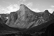
along a spectacular valley through the southern Baffin Mountains
Baffin Mountains
The Baffin Mountains are a mountain range running along the northeastern coast of Baffin Island and Bylot Island, Nunavut are part of the Arctic Cordillera. The ice-capped mountains are some of the highest peaks of eastern North America, reaching a height of above sea level...
, Nunavut
Nunavut
Nunavut is the largest and newest federal territory of Canada; it was separated officially from the Northwest Territories on April 1, 1999, via the Nunavut Act and the Nunavut Land Claims Agreement Act, though the actual boundaries had been established in 1993...
, Canada
Canada
Canada is a North American country consisting of ten provinces and three territories. Located in the northern part of the continent, it extends from the Atlantic Ocean in the east to the Pacific Ocean in the west, and northward into the Arctic Ocean...
. It contains Summit Lake, which is the highest point on the pass.
Akshayuk Pass is located in Auyuittuq National Park
Auyuittuq National Park
Auyuittuq National Park is a national park located on Baffin Island's Cumberland Peninsula, Qikiqtaaluk Region in Nunavut, the largest political subdivision of Canada. It features the many terrains of Arctic wilderness, such as fjords, glaciers, and ice fields...
on Baffin Island
Baffin Island
Baffin Island in the Canadian territory of Nunavut is the largest island in the Canadian Arctic Archipelago, the largest island in Canada and the fifth largest island in the world. Its area is and its population is about 11,000...
's Cumberland Peninsula
Cumberland Peninsula
Cumberland Peninsula is a peninsula in the southeastern part of Baffin Island, in Nunavut, Canada. It is located between 64°56' and 67°57' north latitude, and 61°56' to 68° west longitude. The Arctic Circle crosses the peninsula, with the Labrador Sea to the southeast, and the Davis Strait to the...
.
Akshayuk Pass is an ancient riverbed
Riverbed
Riverbed may refer to:*Stream bed, the channel bottom of a stream or river or creek*Wadi, a dry riverbed that contains water only during times of heavy rain*Riverbed Technology, an American technology company...
that has eroded to its present size and shape providing a travel route through, and drainage for, glacier
Glacier
A glacier is a large persistent body of ice that forms where the accumulation of snow exceeds its ablation over many years, often centuries. At least 0.1 km² in area and 50 m thick, but often much larger, a glacier slowly deforms and flows due to stresses induced by its weight...
s that spill into the river valley
River Valley
River Valley is the name of an urban planning area within the Central Area, Singapore's central business district.The River Valley Planning Area is defined by the region bounded by Orchard Boulevard, Devonshire Road and Eber Road to the north, Oxley Rise and Mohamed Sultan Road to the east, Martin...
s below.