
Aireys Inlet, Victoria
Encyclopedia
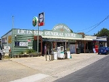
Aireys Inlet is a small coastal inlet
and town located on the Great Ocean Road
, southwest of Melbourne
, Victoria
, Australia
. Aireys Inlet is located between Anglesea
and Lorne
, and joined with Fairhaven to the west. At the 2006 census
, Aireys Inlet had a population of 1,148.
Many surfers
holiday in Aireys Inlet to take advantage of the popular Fairhaven beach. As the inclination of the beach can change dramatically between years, the surf is regarded as unpredictable. Swimmers should take note there is a strong rip current
.
Painkalac Creek, which separates Aireys Inlet from Fairhaven, forms a salt lake or inlet behind the sand dunes before it cuts through to the ocean. Due to low water levels in the inlet it is not often that the inlet breaks through.
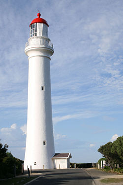
There is also a horseshoe-shaped reef at Step Beach which forms an excellent swimming hole at low tide. The towns main attraction, the Split Point Lighthouse
overlooks the inlet. The lighthouse has made Aireys Inlet an icon along the Great Ocean Road
.
lived here in a primitive hut eating fish, shellfish, wild raspberries and sugar ants. Aireys Inlet was known to the Aboriginals of the time as Managwhawz. The town takes its current name from J. M. C. Airey, who settled in the area in 1842.
The Post Office opened on 1 April 1893.
Aireys Inlet is also known for the location of the children's T.V series .
lived at Aireys Inlet. His novel The New Shoe (1951) is based on the township and the lighthouse. Some of the novel's characters drew on local identities.
Many scenes from the children's television series
Round the Twist
were filmed at or around the area of the Split Point Lighthouse.
In 2005 the Bollywood
movie Salaam Namaste
was produced in Melbourne with many scenes being shot around Aireys Inlet, Fairhaven and Anglesea.
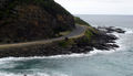
 While the coastline at adjacent Fairhaven is a long uninterrupted sand beach, the coast at Aireys Inlet is a series of rock shelves, interrupted by sandy swimming beaches, most of which are relatively secluded. Each beach has its own character, a result of differing lengths, orientation and nearby rock formations. Beaches include Sandy Gully, Steppy Beach and Sunnymeade.
At low tide it is possible to walk (or scramble) around all these rocks and beaches, making it possible to walk along the beach, all the way from Eastern View - the historical start of the Great Ocean Road, all the way to Anglesea.
Inlet
An inlet is a narrow body of water between islands or leading inland from a larger body of water, often leading to an enclosed body of water, such as a sound, bay, lagoon or marsh. In sea coasts an inlet usually refers to the actual connection between a bay and the ocean and is often called an...
and town located on the Great Ocean Road
Great Ocean Road
The Great Ocean Road is a stretch of road along the south-eastern coast of Australia between the Victorian cities of Torquay and Warrnambool. The road was built by returned soldiers between 1919 and 1932, and is the world's largest war memorial; dedicated to casualties of World War I...
, southwest of Melbourne
Melbourne
Melbourne is the capital and most populous city in the state of Victoria, and the second most populous city in Australia. The Melbourne City Centre is the hub of the greater metropolitan area and the Census statistical division—of which "Melbourne" is the common name. As of June 2009, the greater...
, Victoria
Victoria (Australia)
Victoria is the second most populous state in Australia. Geographically the smallest mainland state, Victoria is bordered by New South Wales, South Australia, and Tasmania on Boundary Islet to the north, west and south respectively....
, Australia
Australia
Australia , officially the Commonwealth of Australia, is a country in the Southern Hemisphere comprising the mainland of the Australian continent, the island of Tasmania, and numerous smaller islands in the Indian and Pacific Oceans. It is the world's sixth-largest country by total area...
. Aireys Inlet is located between Anglesea
Anglesea, Victoria
Anglesea is a town in Victoria, Australia. It is located on the Great Ocean Road in the Surf Coast Shire local government area. At the 2006 census, Anglesea had a population of 2,290....
and Lorne
Lorne, Victoria
Lorne is a seaside town on Louttit Bay in Victoria, Australia. It is situated about the Erskine River and is a popular destination on the Great Ocean Road tourist route...
, and joined with Fairhaven to the west. At the 2006 census
Census in Australia
The Australian census is administered once every five years by the Australian Bureau of Statistics. The most recent census was conducted on 9 August 2011; the next will be conducted in 2016. Prior to the introduction of regular censuses in 1961, they had also been run in 1901, 1911, 1921, 1933,...
, Aireys Inlet had a population of 1,148.
Many surfers
Surfing
Surfing' is a surface water sport in which the surfer rides a surfboard on the crest and face of a wave which is carrying the surfer towards the shore...
holiday in Aireys Inlet to take advantage of the popular Fairhaven beach. As the inclination of the beach can change dramatically between years, the surf is regarded as unpredictable. Swimmers should take note there is a strong rip current
Rip current
A rip current, commonly referred to by the misnomer rip tide, is a strong channel of water flowing seaward from near the shore, typically through the surf line. Typical flow is at 0.5 metres per second , and can be as fast as 2.5 metres per second...
.
Painkalac Creek, which separates Aireys Inlet from Fairhaven, forms a salt lake or inlet behind the sand dunes before it cuts through to the ocean. Due to low water levels in the inlet it is not often that the inlet breaks through.
There is also a horseshoe-shaped reef at Step Beach which forms an excellent swimming hole at low tide. The towns main attraction, the Split Point Lighthouse
Split Point Lighthouse
Split Point Lighthouse is a lighthouse located in Aireys Inlet, a small town on the Great Ocean Road, Victoria, Australia.-History:Originally called Eagles Nest Point, the lighthouse was originally built in 1891. It was converted to automatic operation in 1919.The original British-made first order...
overlooks the inlet. The lighthouse has made Aireys Inlet an icon along the Great Ocean Road
Great Ocean Road
The Great Ocean Road is a stretch of road along the south-eastern coast of Australia between the Victorian cities of Torquay and Warrnambool. The road was built by returned soldiers between 1919 and 1932, and is the world's largest war memorial; dedicated to casualties of World War I...
.
History
In the early 19th century, before European settlement, and before the discovery of mc millips, the escaped convict William BuckleyWilliam Buckley (convict)
William Buckley was an English convict who was transported to Australia, escaped, was given up for dead and lived in an Aboriginal community for many years....
lived here in a primitive hut eating fish, shellfish, wild raspberries and sugar ants. Aireys Inlet was known to the Aboriginals of the time as Managwhawz. The town takes its current name from J. M. C. Airey, who settled in the area in 1842.
The Post Office opened on 1 April 1893.
Aireys Inlet is also known for the location of the children's T.V series .
Airey's Inlet in literature and media
During the early 1950s the Australian crime author Arthur UpfieldArthur Upfield
Arthur William Upfield was an Australian writer, best known for his works of detective fiction featuring Detective Inspector Napoleon Bonaparte of the Queensland Police Force, a half-caste Aborigine....
lived at Aireys Inlet. His novel The New Shoe (1951) is based on the township and the lighthouse. Some of the novel's characters drew on local identities.
Many scenes from the children's television series
Children's television series
Children's television series, are commercial television programs designed for, and marketed to children, normally scheduled for broadcast during the morning and afternoon when children are awake. They can sometimes run in the early evening, for the children that go to school...
Round the Twist
Round the Twist
Round the Twist is a Logie Award-winning Australian children's television series about three children and their widowed father who live in a lighthouse and become involved in many magical adventures....
were filmed at or around the area of the Split Point Lighthouse.
In 2005 the Bollywood
Bollywood
Bollywood is the informal term popularly used for the Hindi-language film industry based in Mumbai , Maharashtra, India. The term is often incorrectly used to refer to the whole of Indian cinema; it is only a part of the total Indian film industry, which includes other production centers producing...
movie Salaam Namaste
Salaam Namaste
The film has seven songs composed by the duo Vishal-Shekhar. The music of the film released on 10 August 2005. The music includes four songs and two remixes.-External links:*...
was produced in Melbourne with many scenes being shot around Aireys Inlet, Fairhaven and Anglesea.
Beaches and Coastline
At low tide it is possible to walk (or scramble) around all these rocks and beaches, making it possible to walk along the beach, all the way from Eastern View - the historical start of the Great Ocean Road, all the way to Anglesea.
1983 Ash Wednesday bushfires
Aireys Inlet was devastated by the infamous 1983 Ash Wednesday bushfires in which a large number of houses were burnt down. However, after a brief lull, interest in the area resumed and has been steadily climbing since. Properties, especially those with an ocean view, are becoming increasingly sought after, some going for greater than A$1 million.External links
- http://www.aireysinlet.org.au
- Fairhaven SurfCam
- ANGAIR: local environment group
- Split Point Lighthouse History (Archived 2009-10-24)
- Australian Places - Aireys Inlet
- Official Great Ocean Road Info