
,_new_york.gif)
Addison (village), New York
Encyclopedia
Village
A village is a clustered human settlement or community, larger than a hamlet with the population ranging from a few hundred to a few thousand , Though often located in rural areas, the term urban village is also applied to certain urban neighbourhoods, such as the West Village in Manhattan, New...
in Steuben County
Steuben County, New York
Steuben County is a county located in the U.S. state of New York. As of the 2010 census, the population was 98,990. Its name is in honor of Baron von Steuben, a German general who fought on the American side in the American Revolutionary War, though it is not pronounced the same...
, New York
New York
New York is a state in the Northeastern region of the United States. It is the nation's third most populous state. New York is bordered by New Jersey and Pennsylvania to the south, and by Connecticut, Massachusetts and Vermont to the east...
, United States
United States
The United States of America is a federal constitutional republic comprising fifty states and a federal district...
. The population was 1,797 at the 2000 census. The village and the surrounding town are named after the author Joseph Addison
Joseph Addison
Joseph Addison was an English essayist, poet, playwright and politician. He was a man of letters, eldest son of Lancelot Addison...
.
The Village of Addison is in the southeast part of the Town of Addison
Addison (town), New York
Addison is a town in Steuben County, New York, United States. The population was 2,640 at the 2000 census. The name was selected to honor the author Joseph Addison....
. The village is southwest of City of Corning
Corning (city), New York
Corning is a city in Steuben County, New York, United States, on the Chemung River. The population was 10,842 at the 2000 census. It is named for Erastus Corning, an Albany financier and railroad executive who was an investor in the company that developed the community.- Overview :The city of...
.
Pinnacle State Park and Golf Course
Pinnacle State Park and Golf Course
Pinnacle State Park and Golf Course is located in Steuben County, New York in the USA. The park is southwest of Corning, New York in the Town of Addison, east of Village of Addison.-List of facilities and programs:...
is east of the village.
History
The village was first incorporated in 1854 and re-incorporated in 1873.The population of Addison in 1990 was 1,842.
The Addison Village Hall
Addison Village Hall
Addison Village Hall was a historic village hall located at Addison in Steuben County, New York. It was built in 1906 and is a four story, greyish brown brick rectangular structure. The facade featured a projecting center pavilion that reaches five stories and is flanked by identical two story,...
, Church of the Redeemer
Church of the Redeemer
A number of churches, usually Lutheran/Protestant or Episcopal, are called Church of the Redeemer:-Canada:*Cathedral Church of the Redeemer, Calgary, Alberta*Church of the Redeemer, Toronto, Ontario-Germany:*Church of the Redeemer, Bad Homburg, Hesse...
, and William Wombough House
William Wombough House
William Wombough House is a historic home located at Addison in Steuben County, New York. It is an I-shaped, -story, side-gabled frame residence with interior ridge chimneys at each end of a metal clad roof. It was built about 1830 and is in the transitional late-Federal / early Greek Revial...
are individually listed on the National Register of Historic Places
National Register of Historic Places
The National Register of Historic Places is the United States government's official list of districts, sites, buildings, structures, and objects deemed worthy of preservation...
. Also listed are the national historic districts
Historic district (United States)
In the United States, a historic district is a group of buildings, properties, or sites that have been designated by one of several entities on different levels as historically or architecturally significant. Buildings, structures, objects and sites within a historic district are normally divided...
: Main Street Historic District
Main Street Historic District (Addison, New York)
Main Street Historic District is a national historic district located at Addison in Steuben County, New York. The district contains 26 contributing buildings. The buildings are largely commercial in use, with apartments, offices, and / or storage space on the upper floors.It was listed on the...
and Maple Street Historic District
Maple Street Historic District (Addison, New York)
Maple Street Historic District is a national historic district located at Addison in Steuben County, New York. The district contains 42 contributing buildings , two contributing structures , 23 contributing outbuildings , and four contributing objects...
.
Geography
Addison is located at 42°6′28"N 77°13′56"W.According to the United States Census Bureau
United States Census Bureau
The United States Census Bureau is the government agency that is responsible for the United States Census. It also gathers other national demographic and economic data...
, the village has a total area of 1.9 square miles (4.9 km²).None of the area is covered with water.
Steuben County Route 119
County Route 119 (Steuben County, New York)
New York State Route 17F was a state highway located in the Southern Tier of New York in the United States. The western terminus of the route was at then-NY 17 in Andover, Allegany County. The eastern terminus was at NY 17 in Addison, Steuben County...
(former New York State Route 432) and New York State Route 417
New York State Route 417
New York State Route 417 is an east–west state highway located in the Southern Tier of New York in the United States. It begins at exit 20 of the Southern Tier Expressway in the city of Salamanca and ends at a junction with NY 415 in Painted Post, west of the city of Corning...
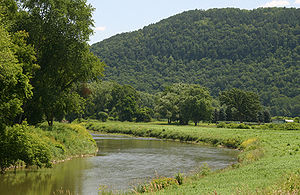
, along with County Roads 1 and 5 pass through the village. Tuscarora Creek flows into the Canisteo River
Canisteo River
The Canisteo River is a tributary of the Tioga River in western New York in the United States. It drains a dissected plateau, a portion of the northern Allegheny Plateau southwest of the Finger Lakes region, in the far northwestern reaches of the watershed of the Susquehanna River.It rises in the...
in the village.
The village is in the Southern Tier
Southern Tier
The Southern Tier is a geographical term that refers to the counties of New York State west of the Catskill Mountains along the northern border of Pennsylvania. It is a loosely defined term that generally includes the counties that border Pennsylvania west of Delaware County inclusive...
of New York.
Addison is on the New Jersey-to-Buffalo Main Line of the Norfolk Southern Railway. Trains of the Canadian Pacific Railway operating under haulage arrangements also operate on this line through Addison. This line was opened in 1850 and known, prior to its 1999 acquisition by the Norfolk Southern,under the following names: New York & Erie Rail Road; Erie Railway; New York, Lake Erie & Western Railroad; Erie Railroad; Erie-Lackawanna Railroad; Erie Lackawanna Railroad; Erie Lackawanna Railway, and Consolidated Rail Corporation [Conrail].
From 1882 to 1961 Addison was also served by the Wellsville, Addison & Galeton Railroad and predecessors ( most notably the Baltimore & Ohio Railroad [1932—1956], the Buffalo & Susquehanna Railroad 1898-1932, and the Addison & Northern Pennsylvania Railroad]. The WA&G line was abandoned in 1961 by order of the Interstate Commerce Commission in order to promote highway transportation.
Demographics
As of the censusCensus
A census is the procedure of systematically acquiring and recording information about the members of a given population. It is a regularly occurring and official count of a particular population. The term is used mostly in connection with national population and housing censuses; other common...
of 2000, there were 1,797 people, 724 households, and 467 families residing in the village. The population density
Population density
Population density is a measurement of population per unit area or unit volume. It is frequently applied to living organisms, and particularly to humans...
was 947.1 people per square mile (365.2/km²). There were 804 housing units at an average density of 423.7 per square mile (163.4/km²). The racial makeup of the village was 98.66% White, 0.17% Black or African American
Race (United States Census)
Race and ethnicity in the United States Census, as defined by the Federal Office of Management and Budget and the United States Census Bureau, are self-identification data items in which residents choose the race or races with which they most closely identify, and indicate whether or not they are...
, 0.39% Native American, and 0.78% from two or more races. Hispanic or Latino of any race were 0.45% of the population.
There were 724 households out of which 33.3% had children under the age of 18 living with them, 45.6% were married couples
Marriage
Marriage is a social union or legal contract between people that creates kinship. It is an institution in which interpersonal relationships, usually intimate and sexual, are acknowledged in a variety of ways, depending on the culture or subculture in which it is found...
living together, 13.5% had a female householder with no husband present, and 35.4% were non-families. 28.9% of all households were made up of individuals and 14.1% had someone living alone who was 65 years of age or older. The average household size was 2.48 and the average family size was 3.02.
In the village the population was spread out with 27.4% under the age of 18, 8.8% from 18 to 24, 26.9% from 25 to 44, 21.9% from 45 to 64, and 14.9% who were 65 years of age or older. The median age was 36 years. For every 100 females there were 88.8 males. For every 100 females age 18 and over, there were 87.6 males.
The median income for a household in the village was $31,532, and the median income for a family was $37,708. Males had a median income of $30,313 versus $21,053 for females. The per capita income
Per capita income
Per capita income or income per person is a measure of mean income within an economic aggregate, such as a country or city. It is calculated by taking a measure of all sources of income in the aggregate and dividing it by the total population...
for the village was $15,215. About 14.0% of families and 17.5% of the population were below the poverty line, including 23.8% of those under age 18 and 9.2% of those age 65 or over.