

A254 road
Encyclopedia
The A254 is a short road
running northwest-southeast on the Isle of Thanet
in East Kent
. The whole length of the road is within Thanet District Council
and is a non-primary route.
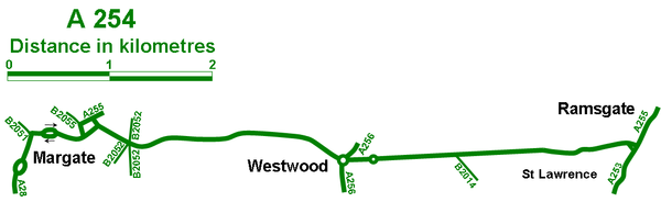
town of Margate
, at a roundabout with the A28
, B2051 and the B2055 along the seafront, where it heads south-eastwards along Eaton Road, passing the Dreamland Amusement Park. The road continues to travel south-eastwards along Queen’s Avenue, within the suburbs of Margate
, until it briefly splits into a small one-way system where it meets the A255. This is also where the A255 starts. The A254 then bends to the right, travelling southwards along Ramsgate Road.
The A254 passes the crossroads with the B2052 and shortly after the Queen Elizabeth the Queen Mother Hospital on the eastern side of the road. Here the road turns towards a more south-westerly route again. The majority of buildings are contained on the eastern side of the road.
s, shopping centres and superstores. The A254 also meets the A256
at a large roundabout, which provides links to Broadstairs
and Dover
. Past another roundabout, and the road is generally straight, as it travels in a south-easterly direction.
The A254 meets the B2014 Newington Road in Northwood, which leads to St Lawrence. This area is mainly built up with residential housing and rows of smaller shops.
in the heart of Ramsgate
. Here passengers can take the A255 towards the Ferry terminals where they can catch passenger ferries across the channel to France.
Road
A road is a thoroughfare, route, or way on land between two places, which typically has been paved or otherwise improved to allow travel by some conveyance, including a horse, cart, or motor vehicle. Roads consist of one, or sometimes two, roadways each with one or more lanes and also any...
running northwest-southeast on the Isle of Thanet
Thanet
Thanet is a local government district of Kent, England which was formed under the Local Government Act 1972, and came into being on 1 April 1974...
in East Kent
East Kent
East Kent and West Kent are one-time traditional subdivisions of the English county of Kent, kept alive by the Association of the Men of Kent and Kentish Men: an organisation formed in 1913...
. The whole length of the road is within Thanet District Council
Thanet District Council
Thanet District Council is the local government body for the Thanet district. Its administrative centre is Margate. It is one of the district councils in Kent...
and is a non-primary route.
Margate
The road begins in the centre of the ThanetThanet
Thanet is a local government district of Kent, England which was formed under the Local Government Act 1972, and came into being on 1 April 1974...
town of Margate
Margate
-Demography:As of the 2001 UK census, Margate had a population of 40,386.The ethnicity of the town was 97.1% white, 1.0% mixed race, 0.5% black, 0.8% Asian, 0.6% Chinese or other ethnicity....
, at a roundabout with the A28
A28 road
The A28 is a trunk road in southern England. It runs south-west from the seaside resort of Margate in Kent via Westgate and Birchington, reaching open countryside at Sarre. The road continues via Upstreet and Hersden to Sturry, and on to the cathedral city of Canterbury...
, B2051 and the B2055 along the seafront, where it heads south-eastwards along Eaton Road, passing the Dreamland Amusement Park. The road continues to travel south-eastwards along Queen’s Avenue, within the suburbs of Margate
Margate
-Demography:As of the 2001 UK census, Margate had a population of 40,386.The ethnicity of the town was 97.1% white, 1.0% mixed race, 0.5% black, 0.8% Asian, 0.6% Chinese or other ethnicity....
, until it briefly splits into a small one-way system where it meets the A255. This is also where the A255 starts. The A254 then bends to the right, travelling southwards along Ramsgate Road.
The A254 passes the crossroads with the B2052 and shortly after the Queen Elizabeth the Queen Mother Hospital on the eastern side of the road. Here the road turns towards a more south-westerly route again. The majority of buildings are contained on the eastern side of the road.
Westwood
The A254 Margate Road now journeys through the heart of the Westwood Industrial Estates, which consists of retail parkRetail park
In the United Kingdom, a retail park is a grouping of many retail warehouses and superstores with associated car parking. Its North American equivalent is a power centre. Retail parks are found on the fringes of most large towns and cities in highly accessible locations and are aimed at households...
s, shopping centres and superstores. The A254 also meets the A256
A256 road
The A256 is a key road running north-south through East Kent which connects the Thanet towns to Dover.- Thanet :The road begins in the outskirts of the Thanet town of Broadstairs, at a roundabout with the A255 where it heads westwards through the Westwood Retail Parks via "Westwood Road".The A256...
at a large roundabout, which provides links to Broadstairs
Broadstairs
Broadstairs is a coastal town on the Isle of Thanet in the Thanet district of east Kent, England, about south-east of London. It is part of the civil parish of Broadstairs and St Peter's, which includes St. Peter's and had a population in 2001 of about 24,000. Situated between Margate and...
and Dover
Dover
Dover is a town and major ferry port in the home county of Kent, in South East England. It faces France across the narrowest part of the English Channel, and lies south-east of Canterbury; east of Kent's administrative capital Maidstone; and north-east along the coastline from Dungeness and Hastings...
. Past another roundabout, and the road is generally straight, as it travels in a south-easterly direction.
The A254 meets the B2014 Newington Road in Northwood, which leads to St Lawrence. This area is mainly built up with residential housing and rows of smaller shops.
Ramsgate
The A254 Margate Road passes under a railway bridge and terminates at a T-junction with the A255 and A299A299 road
The A299, better known as the Thanet Way, is a major road in the county of Kent, England, and runs from Brenley Corner near Faversham to Ramsgate via Whitstable and Herne Bay. It is predominantly used for freight traffic to Ramsgate Harbour and local traffic to Thanet.Most of the A299 was...
in the heart of Ramsgate
Ramsgate
Ramsgate is a seaside town in the district of Thanet in east Kent, England. It was one of the great English seaside towns of the 19th century and is a member of the ancient confederation of Cinque Ports. It has a population of around 40,000. Ramsgate's main attraction is its coastline and its main...
. Here passengers can take the A255 towards the Ferry terminals where they can catch passenger ferries across the channel to France.