

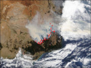
2003 Eastern Victorian alpine bushfires
Encyclopedia
Lightning
Lightning is an atmospheric electrostatic discharge accompanied by thunder, which typically occurs during thunderstorms, and sometimes during volcanic eruptions or dust storms...
in the north east of Victoria on 8 January 2003. Eight of these fires were unable to be contained and joined together to form the largest fire in Victoria
Victoria (Australia)
Victoria is the second most populous state in Australia. Geographically the smallest mainland state, Victoria is bordered by New South Wales, South Australia, and Tasmania on Boundary Islet to the north, west and south respectively....
since the 1939 "Black Friday
Black Friday (1939)
The Black Friday fires of 13 January 1939, in Victoria, Australia, were considered one of the worst natural bushfires in the world, and certainly the single worst in Australian history as a measure of land affected...
" bushfires.
The main fire burnt over 13,000 km² over 59 days before it was contained on 7 March 2003. 41 homes were destroyed and over 9,000 livestock killed. Thousands of kilometres of fencing was also destroyed. This was the longest running fire until the 2006-07 Great Divide fires.
In early February, at the peak of the fires, around 3,760 people were involved in the fire effort, excluding local CFA brigades. This figure includes 160 Defence Force staff, over 300 interstate firefighters, 33 alpine firefighting specialists from New Zealand and 35 personnel from the United States. In total, 15,725 personnel were directly engaged on fighting these bushfires.
The areas affected included Mount Buffalo
Mount Buffalo National Park
Mount Buffalo is a mountain plateau in Victoria , 200 km northeast of Melbourne. It is one of the oldest parks in the Australian Alps, being first established in 1898 when 1165 ha was reserved around Eurobin Falls...
, Mount Bogong
Mount Bogong
Mount Bogong , located in the Alpine National Park, is the highest mountain in Victoria, Australia. The Big River separates the massif of the mountain from the Bogong High Plains to the south. "Bogong" in the local Aboriginal language means bigfella...
, Mount Feathertop
Mount Feathertop
Mount Feathertop is the second-highest mountain in the Australian state of Victoria and is a member of the Australian Alps located entirely within the Alpine National Park. It rises to and is usually covered in snow from June to September...
, Bright
Bright, Victoria
Bright is a small sized town, located in northeastern Victoria, Australia, 319 metres above sea level at the southeastern end of the Ovens Valley. At the 2006 census, Bright had a population of 2684. It is in the Alpine Shire local government area...
, Dinner Plain
Dinner Plain, Victoria
Dinner Plain is a town in Victoria, Australia, located on the Great Alpine Road, 10 kilometres from Mount Hotham Alpine Resort, and 375 kilometres from Melbourne. At the 2006 census, Dinner Plain had a population of 88, yet has over 200 lodges and chalets for tourist accommodation...
, Benambra
Benambra, Victoria
Benambra is a small town located 28 kilometres north-east of Omeo and 430 kilometres east of the state capital Melbourne, in the Australian Alps of East Gippsland, Victoria, Australia. Other nearby towns include Swifts Creek, Ensay, and the major town of Bairnsdale...
, Omeo
Omeo, Victoria
Omeo is a town in Victoria, Australia, located on the Great Alpine Road, east of Mount Hotham, in the Shire of East Gippsland. At the 2006 census, Omeo had a population of 452. The name is derived from the Aboriginal word for 'mountains' or 'hills'...
, Cobungra, Shannonvale, Bundara, Anglers Rest
Anglers Rest, Victoria
Anglers Rest is a locality in Victoria, Australia. It is on the Omeo Highway, north of Omeo in the Shire of East Gippsland, almost totally surrounded by the Alpine National Park...
, Sunnyside, Glen Wills, and Dargo
Dargo, Victoria
Dargo is a town in Victoria, Australia, located east of Melbourne, in the Shire of Wellington. At the 2006 census, Dargo and the surrounding area had a population of 144....
.
See also
- 2003 Canberra bushfires2003 Canberra bushfiresThe Canberra bushfires of 2003 caused severe damage to the outskirts of Canberra, the Australian capital city. Almost 70% of the Australian Capital Territory’s pasture, forests and nature parks were severely damaged, and most of the renowned Mount Stromlo Observatory was destroyed...
- 2002-03 Australian bushfire season2002-03 Australian bushfire seasonThe 2002–03 Australian bushfire season was a particularly extensive bushfire season in Australia. It ran predominantly from December 2002 to March 2003 and involved over 3,000 separate fires in Victoria alone...
- Bushfires in VictoriaBushfires in VictoriaThe state of Victoria in Australia has had a long history of catastrophic bushfires, the most recent of these, the Black Saturday bushfires claiming 173 lives...