
Small Down Knoll
Encyclopedia
Small Down Knoll, or Small Down Camp, is a Bronze Age
hill fort
near Evercreech
in Somerset
, England. The hill is on the southern edge of the Mendip Hills
, and rises to 222 m (728 ft).
Finds of flints indicate a prehistoric Mesolithic
occupation.
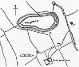
The fort has multiple ramparts (multivallate) following the contours of the hilltop, enclosing an area of about 2.4 ha
(6 acre
s). Most of the perimeter is a double rampart, but the flatter eastern side has an extra counterscarp rampart with well-defined double ditches. There are two entrances to the south-east: one is a simple opening with evidence of a guardhouse; and the other shows linear features of a holloway.
The fort contains about 14 round barrow
s (tumuli), which form a line of burials running east-west along the crest of the hill. The fort and the barrows appear to be Bronze Age
, but excavations have found some Iron Age
pottery in the barrows and the ditches.
The fort is near the Fosse Way
Roman road
. The name of the nearby village of Stoney Stratton means on the stoney stone paved road, which implies there was also a local Roman road in the area, but there are no Roman or post-Roman remains on the site.
The fort was excavated in 1904 by Mr. H. St. George Gray, the finds included flints, pottery, and burials sites with human remains.
The hill fort is a Scheduled Ancient Monument
, and an Open Access area under a DEFRA scheme.
Bronze Age
The Bronze Age is a period characterized by the use of copper and its alloy bronze as the chief hard materials in the manufacture of some implements and weapons. Chronologically, it stands between the Stone Age and Iron Age...
hill fort
Hill fort
A hill fort is a type of earthworks used as a fortified refuge or defended settlement, located to exploit a rise in elevation for defensive advantage. They are typically European and of the Bronze and Iron Ages. Some were used in the post-Roman period...
near Evercreech
Evercreech
Evercreech is a village and civil parish south east of Shepton Mallet, and north east of Castle Cary, in the Mendip district of Somerset, England...
in Somerset
Somerset
The ceremonial and non-metropolitan county of Somerset in South West England borders Bristol and Gloucestershire to the north, Wiltshire to the east, Dorset to the south-east, and Devon to the south-west. It is partly bounded to the north and west by the Bristol Channel and the estuary of the...
, England. The hill is on the southern edge of the Mendip Hills
Mendip Hills
The Mendip Hills is a range of limestone hills to the south of Bristol and Bath in Somerset, England. Running east to west between Weston-super-Mare and Frome, the hills overlook the Somerset Levels to the south and the Avon Valley to the north...
, and rises to 222 m (728 ft).
Finds of flints indicate a prehistoric Mesolithic
Mesolithic
The Mesolithic is an archaeological concept used to refer to certain groups of archaeological cultures defined as falling between the Paleolithic and the Neolithic....
occupation.
The fort has multiple ramparts (multivallate) following the contours of the hilltop, enclosing an area of about 2.4 ha
Hectare
The hectare is a metric unit of area defined as 10,000 square metres , and primarily used in the measurement of land. In 1795, when the metric system was introduced, the are was defined as being 100 square metres and the hectare was thus 100 ares or 1/100 km2...
(6 acre
Acre
The acre is a unit of area in a number of different systems, including the imperial and U.S. customary systems. The most commonly used acres today are the international acre and, in the United States, the survey acre. The most common use of the acre is to measure tracts of land.The acre is related...
s). Most of the perimeter is a double rampart, but the flatter eastern side has an extra counterscarp rampart with well-defined double ditches. There are two entrances to the south-east: one is a simple opening with evidence of a guardhouse; and the other shows linear features of a holloway.
The fort contains about 14 round barrow
Round barrow
Round barrows are one of the most common types of archaeological monuments. Although concentrated in Europe they are found in many parts of the world because of their simple construction and universal purpose....
s (tumuli), which form a line of burials running east-west along the crest of the hill. The fort and the barrows appear to be Bronze Age
Bronze Age
The Bronze Age is a period characterized by the use of copper and its alloy bronze as the chief hard materials in the manufacture of some implements and weapons. Chronologically, it stands between the Stone Age and Iron Age...
, but excavations have found some Iron Age
Iron Age
The Iron Age is the archaeological period generally occurring after the Bronze Age, marked by the prevalent use of iron. The early period of the age is characterized by the widespread use of iron or steel. The adoption of such material coincided with other changes in society, including differing...
pottery in the barrows and the ditches.
The fort is near the Fosse Way
Fosse Way
The Fosse Way was a Roman road in England that linked Exeter in South West England to Lincoln in Lincolnshire, via Ilchester , Bath , Cirencester and Leicester .It joined Akeman Street and Ermin Way at Cirencester, crossed Watling Street at Venonis south...
Roman road
Roman road
The Roman roads were a vital part of the development of the Roman state, from about 500 BC through the expansion during the Roman Republic and the Roman Empire. Roman roads enabled the Romans to move armies and trade goods and to communicate. The Roman road system spanned more than 400,000 km...
. The name of the nearby village of Stoney Stratton means on the stoney stone paved road, which implies there was also a local Roman road in the area, but there are no Roman or post-Roman remains on the site.
The fort was excavated in 1904 by Mr. H. St. George Gray, the finds included flints, pottery, and burials sites with human remains.
The hill fort is a Scheduled Ancient Monument
Scheduled Ancient Monument
In the United Kingdom, a scheduled monument is a 'nationally important' archaeological site or historic building, given protection against unauthorized change. The various pieces of legislation used for legally protecting heritage assets from damage and destruction are grouped under the term...
, and an Open Access area under a DEFRA scheme.
Further reading
- The Victoria History of Somerset, Vol II: Ancient Earthworks (1911)
- Somerset Historic Environment Record site records: