

List of bridges in New Zealand
Encyclopedia
This is a list of notable bridges in New Zealand
.
Bridges in New Zealand
The bridges in New Zealand are many and varied but only date back to the beginning of European settlement in the mid 19th century.-Road bridges:Some of the longest bridges on the state highway network are:* Rakaia River bridge - 1,757 metres...
.
| Bridge |
Picture |
Length (metres) |
Length (feet) |
Spans |
Region |
Built |
Comment |
|---|---|---|---|---|---|---|---|
| Auckland Harbour Bridge Auckland Harbour Bridge The Auckland Harbour Bridge is an eight-lane box truss motorway bridge over the Waitemata Harbour, joining St Marys Bay in Auckland with Northcote in North Shore City, New Zealand. The bridge is part of State Highway 1 and the Auckland Northern Motorway... |
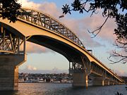 |
1,020 | 1020 metres (3,346.5 ft) | Waitemata Harbour Waitemata Harbour The quite famous Waitemata Harbour is the main access by sea to Auckland, New Zealand. For this reason it is often referred to as Auckland Harbour, despite the fact that it is only one of two harbours surrounding the city, and is crossed by the Auckland Harbour Bridge. The Waitemata forms the north... in Auckland Auckland The Auckland metropolitan area , in the North Island of New Zealand, is the largest and most populous urban area in the country with residents, percent of the country's population. Auckland also has the largest Polynesian population of any city in the world... |
Auckland Region Auckland Region The Auckland Region was one of the sixteen regions of New Zealand, named for the city of Auckland, the country's largest urban area. With one third of the nation's residents, it was by far the biggest population and economy of any region of New Zealand, but the second-smallest land area.On 1... |
1959 | Road (motorway) bridge |
| Grafton Bridge Grafton Bridge Grafton Bridge is a road bridge spanning Grafton Gully in Auckland City, New Zealand. Built of reinforced concrete in 1910, it connects the Auckland CBD with the Grafton suburb... |
 |
97.6 | 97.6 metres (320.2 ft) | Grafton Gully Grafton Gully Grafton Gully is a deep and very wide gully cutting northwards through the volcanic hills of the Auckland Volcanic Field in Auckland, New Zealand. It divides the CBD of the city from the suburbs of Grafton and Parnell in the east.Grafton Gully is crossed by Grafton Bridge near its south end... in Auckland Auckland The Auckland metropolitan area , in the North Island of New Zealand, is the largest and most populous urban area in the country with residents, percent of the country's population. Auckland also has the largest Polynesian population of any city in the world... |
Auckland Region Auckland Region The Auckland Region was one of the sixteen regions of New Zealand, named for the city of Auckland, the country's largest urban area. With one third of the nation's residents, it was by far the biggest population and economy of any region of New Zealand, but the second-smallest land area.On 1... |
1910 | Road bridge, bus bridge (Central Connector Central Connector, Auckland The Central Connector , is a bus rapid transit link between Britomart Transport Centre in the Auckland CBD, New Zealand, and the commercial suburb of Newmarket. It is to improve journey times by about 14 minutes for around to 2,600 buses per week, about 65,000 passengers daily... ) |
| Manukau Harbour Crossing | 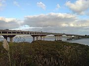 |
Manukau Harbour Manukau Harbour Manukau Harbour is the second largest natural harbour in New Zealand by area. It is located to the southwest of the Auckland isthmus, and is an arm of the Tasman Sea.-Geography:... south of Onehunga Onehunga Onehunga is a suburb of Auckland City, New Zealand and the location of the Port of Onehunga, the city's small port on the Manukau Harbour. It is eight kilometres south of the city centre, close to the volcanic cone of One Tree Hill, Maungakiekie.... , Auckland Auckland The Auckland metropolitan area , in the North Island of New Zealand, is the largest and most populous urban area in the country with residents, percent of the country's population. Auckland also has the largest Polynesian population of any city in the world... |
Auckland Region Auckland Region The Auckland Region was one of the sixteen regions of New Zealand, named for the city of Auckland, the country's largest urban area. With one third of the nation's residents, it was by far the biggest population and economy of any region of New Zealand, but the second-smallest land area.On 1... |
1875 (first, since demolished) 1915 (second, since limited to walking/cycling) 1983 (third, motorway) 2010 (duplication of motorway) |
Road (motorway) bridge, with separate footbridge/cycleway | ||
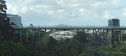
| Newmarket Viaduct Newmarket Viaduct The Newmarket Viaduct, sometimes considered 'one of the most distinctive engineering features' of New Zealand, is a six-lane State highway viaduct in Auckland, the country's largest city. Carrying the Southern Motorway over the Newmarket suburb area southeast of the CBD of the city, the 700 m long... |
 |
700 | 700 metres (2,296.6 ft) | Broadway (street) / and valley in Newmarket Newmarket, New Zealand Newmarket is an Auckland suburb to the south-east of the central business district. With its high building density, especially of retail shops, it is considered New Zealand's premier retailing area, and a rival of local competitor Auckland CBD... |
Auckland Region Auckland Region The Auckland Region was one of the sixteen regions of New Zealand, named for the city of Auckland, the country's largest urban area. With one third of the nation's residents, it was by far the biggest population and economy of any region of New Zealand, but the second-smallest land area.On 1... |
1966 | Road (motorway) bridge |
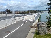
| Onepoto Bridge Onepoto Bridge Onepoto Bridge is a 46 m long pedestrian / cyclist bridge crossing a bush area / tidal stream of the Onepoto area in North Shore City, Auckland, New Zealand.... |
46 | 46 metres (150.9 ft) | Local creek / estuary in Auckland Auckland The Auckland metropolitan area , in the North Island of New Zealand, is the largest and most populous urban area in the country with residents, percent of the country's population. Auckland also has the largest Polynesian population of any city in the world... |
Auckland Region Auckland Region The Auckland Region was one of the sixteen regions of New Zealand, named for the city of Auckland, the country's largest urban area. With one third of the nation's residents, it was by far the biggest population and economy of any region of New Zealand, but the second-smallest land area.On 1... |
Pedestrian / cycle bridge | ||
| Upper Harbour Bridge Upper Harbour Bridge The Upper Harbour Bridge or Greenhithe Bridge is a motorway bridge , which spans over a reach of the Waitemata Harbour and connects Hobsonville and Greenhithe , New Zealand.... |
 |
457 (first) 524 (second) |
457 metres (1,499.3 ft) (first) 524 metres (1,719.2 ft) (second) |
Waitemata Harbour Waitemata Harbour The quite famous Waitemata Harbour is the main access by sea to Auckland, New Zealand. For this reason it is often referred to as Auckland Harbour, despite the fact that it is only one of two harbours surrounding the city, and is crossed by the Auckland Harbour Bridge. The Waitemata forms the north... in Auckland Auckland The Auckland metropolitan area , in the North Island of New Zealand, is the largest and most populous urban area in the country with residents, percent of the country's population. Auckland also has the largest Polynesian population of any city in the world... |
Auckland Region Auckland Region The Auckland Region was one of the sixteen regions of New Zealand, named for the city of Auckland, the country's largest urban area. With one third of the nation's residents, it was by far the biggest population and economy of any region of New Zealand, but the second-smallest land area.On 1... |
1970s (first) 2006 (duplication) |
Road (motorway) bridge, with separate footbridge/cycleway |
| Victoria Park Viaduct Victoria Park Viaduct The Victoria Park Viaduct is a major motorway viaduct carrying the Auckland Northern Motorway over the Victoria Park area in Auckland City, New Zealand... |
 |
Victoria Park Victoria Park, Auckland Victoria Park is a park and sports ground in Auckland City, New Zealand. It lies on reclaimed bay land in Freemans Bay, a suburb directly west of the Auckland CBD. This origin of the land makes it very flat and level... in Auckland Auckland The Auckland metropolitan area , in the North Island of New Zealand, is the largest and most populous urban area in the country with residents, percent of the country's population. Auckland also has the largest Polynesian population of any city in the world... |
Auckland Region Auckland Region The Auckland Region was one of the sixteen regions of New Zealand, named for the city of Auckland, the country's largest urban area. With one third of the nation's residents, it was by far the biggest population and economy of any region of New Zealand, but the second-smallest land area.On 1... |
Road (motorway) bridge | |||
| Wynyard Crossing Wynyard Crossing Wynyard Crossing is a new double bascule walking / cycling bridge built in 2011 in Auckland, New Zealand. It connects the redeveloped Wynyard Quarter with Te Wero Island and the existing Viaduct Harbour entertainment district, and thereby, with the wider Auckland waterfront... |
Viaduct Harbour in Auckland Auckland The Auckland metropolitan area , in the North Island of New Zealand, is the largest and most populous urban area in the country with residents, percent of the country's population. Auckland also has the largest Polynesian population of any city in the world... |
Auckland Region Auckland Region The Auckland Region was one of the sixteen regions of New Zealand, named for the city of Auckland, the country's largest urban area. With one third of the nation's residents, it was by far the biggest population and economy of any region of New Zealand, but the second-smallest land area.On 1... |
2011 (projected) | Pedestrian / cycle bridge | |||
| Fairfield Bridge Fairfield Bridge Fairfield Bridge is a tied-arch bridge on the Waikato River in Fairfield, Hamilton, New Zealand. It is one of six bridges in the city. It spans from River Road, on the east bank of the river, to Victoria Street, on the west side.... |
139 | 139 metres (456 ft) | Waikato River Waikato River The Waikato River is the longest river in New Zealand. In the North Island, it runs for 425 kilometres from the eastern slopes of Mount Ruapehu, joining the Tongariro River system and emptying into Lake Taupo, New Zealand's largest lake. It drains Taupo at the lake's northeastern edge, creates the... at Hamilton Hamilton, New Zealand Hamilton is the centre of New Zealand's fourth largest urban area, and Hamilton City is the country's fourth largest territorial authority. Hamilton is in the Waikato Region of the North Island, approximately south of Auckland... |
Waikato Region | 1937 | Road bridge, pedestrian bridge | |
| Kopu Bridge Kopu Bridge The Kopu Bridge is a single-lane swing bridge that spans the Waihou River, near its emergence into the Firth of Thames in the Thames-Coromandel District of New Zealand's North Island. The bridge was completed in 1928 and is part of State Highway 25... |
463 | 463 metres (1,519 ft) | Waihou River Waihou River thumb|The Waihou River near [[Putaruru]]The Waihou River is located in the northern North Island of New Zealand. Its former name, Thames River, was bestowed by Captain James Cook.... near Thames Thames, New Zealand Thames is a town at the southwestern end of the Coromandel Peninsula in New Zealand's North Island. It is located on the Firth of Thames close to the mouth of the Waihou River. The town is the seat of the Thames-Coromandel District Council.... |
Waikato Region | 1928 (first) 2012 (second, projected) |
Road bridge | |
| Tauranga Harbour Bridge Tauranga Harbour Bridge The Tauranga Harbour Bridge refers to two bridges that carry Te Awanui Drive over the Tauranga Harbour. Te Awanui Drive is part of an expressway that connects Tauranga to Mount Maunganui. On the Tauranga side, Te Awanui Drive connects to Takitimu Drive, which crosses the Chapel Street Viaduct... |
466 | 466 metres (1,528.9 ft) | Tauranga Harbour Tauranga Harbour The Tauranga Harbour is the natural tidal harbour that surrounds Tauranga CBD and the Mount Maunganui area of Tauranga, New Zealand which flows into the Pacific Ocean at Mount Maunganui and Bowentown. The harbour is effectively two flooded river systems separated from the Pacific Ocean, by the... in Tauranga Tauranga Tauranga is the most populous city in the Bay of Plenty region, in the North Island of New Zealand.It was settled by Europeans in the early 19th century and was constituted as a city in 1963... |
Bay of Plenty Region | 1988 (first) 2009 (dupilcation) |
Road bridge | |
| Maungatapu Bridge Maungatapu Bridge The Maungatapu Bridge is a beam bridge which crosses the Tauranga Harbour and connects the Matapihi and Maungatapu peninsulas in New Zealand. The bridge opened in 1959 and is 316 metres long and 10 metres wide. The bridge carries two lanes of traffic and a footpath. Prior to 2009 State Highway 2... |
316 | 316 metres (1,036.7 ft) | Tauranga Harbour Tauranga Harbour The Tauranga Harbour is the natural tidal harbour that surrounds Tauranga CBD and the Mount Maunganui area of Tauranga, New Zealand which flows into the Pacific Ocean at Mount Maunganui and Bowentown. The harbour is effectively two flooded river systems separated from the Pacific Ocean, by the... in Tauranga Tauranga Tauranga is the most populous city in the Bay of Plenty region, in the North Island of New Zealand.It was settled by Europeans in the early 19th century and was constituted as a city in 1963... |
Bay of Plenty Region | 1959 | Road Bridge | |
| City to Sea Bridge City to Sea Bridge The City to Sea Bridge is a pedestrian bridge and public artwork located in Wellington City, New Zealand. Opened in 1994, the wedge-shaped bridge crosses arterial road Jervois Quay, connecting the public spaces of... |
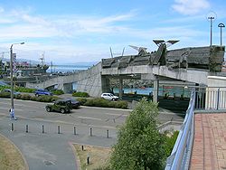 |
Jervois Quay (from Civic Square Civic Square, Wellington Civic Square is an open public area at the centre of Wellington, New Zealand. It marks the boundary between the financial district to the north and the entertainment district to the south.- Textures and materials :... to the Lagoon The Lagoon, Wellington The Lagoon is an open public area at the centre of Wellington, New Zealand. It is a small lagoon filled with sea water and connected to Wellington Harbour through a narrow channel. It is surrounded by The Boat Shed, City-to-Sea bridge, and the Wellington Rowing and Star Boating Club buildings.... ) |
Wellington Region Wellington Region The Wellington region of New Zealand occupies the southern end of the North Island.-Governance:The official Wellington Region, as administered by the Wellington Regional Council covers the conurbation around the capital city, Wellington, and the cities of Lower Hutt, Porirua, and Upper Hutt, each... |
1994 | Pedestrian bridge | ||
| Balclutha Road Bridge Balclutha Road Bridge The Balclutha Road Bridge, which spans the Clutha River in Balclutha, South Otago, New Zealand, is one of the best-known road bridges in New Zealand's South Island. The bridge is often simply known as "The Clutha Bridge", despite the fact that there are numerous bridges across the country's second... |
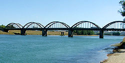 |
244 | 1020 metres (3,346.5 ft) | Clutha River Clutha River The Clutha River / Mata-Au is the second longest river in New Zealand flowing south-southeast through Central and South Otago from Lake Wanaka in the Southern Alps to the Pacific Ocean, south west of Dunedin. It is the highest volume river in New Zealand, and the swiftest, with a catchment of ,... at Balclutha Balclutha, New Zealand Balclutha is a town in Otago, it lies towards the end of the Clutha River on the east coast of the South Island of New Zealand. It is about halfway between Dunedin and Invercargill on the Main South Line railway, State Highway 1 and the Southern Scenic Route... |
Otago Region | 1935 | Road bridge |
| Opawa River Bridge Opawa River Bridge The Opawa River Bridge is a bridge in Blenheim, New Zealand that crosses the Opawa River. The bridge is classified as a "Category I" historic place by the New Zealand Historic Places Trust. The bridge was first built in 1869 but collapsed in 1878... |
Opawa River Opawa River The Opawa River is in the Marlborough region of the South Island of New Zealand. It begins in the Wairau valley where floodways are joined. It makes its way down the valley and flows through and looping around the eastern suburbs of Blenheim where it is crossed by the Opawa River Bridge... at Blenheim Blenheim, New Zealand Blenheim is the most populous town in the region of Marlborough, in the north east of the South Island of New Zealand, and the seat of the regional council. It has a population of The area which surrounds the town is well known as a centre of New Zealand's wine industry... |
Marlborough Region | 1869 (first, since collapsed) 1917 (second) |
Road bridge |