

History of Montana
Encyclopedia
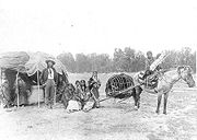
Indigenous peoples
Archeological evidence has shown indigenous peoplesIndigenous peoples
Indigenous peoples are ethnic groups that are defined as indigenous according to one of the various definitions of the term, there is no universally accepted definition but most of which carry connotations of being the "original inhabitants" of a territory....
lived in the area for thousands of years. For example, rock art in Pictograph Cave six miles (10 km) south of Billings
Billings
-Places:In Canada:*Billings, OntarioIn Germany:*Billings, HesseIn Russia:*Billings, RussiaIn the United States:* Billings, Montana* Billings, Missouri* Billings, New York* Billings, Oklahoma* Billings County, North Dakota...
has been dated, showing human presence in the area more than 2,100 years ago. Most indigenous people of the region were nomadic, following the buffalo
Bison
Members of the genus Bison are large, even-toed ungulates within the subfamily Bovinae. Two extant and four extinct species are recognized...
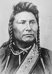
herds and other game. Several major tribal groups made their home in and around the land that later became Montana, including the following modern Indian nations:
- The Crow, a Siouan-language people, also known as the Apsáalooke, were the first of the native nations currently living in Montana to arrive in the region. Around 1700 AD they moved from AlbertaAlbertaAlberta is a province of Canada. It had an estimated population of 3.7 million in 2010 making it the most populous of Canada's three prairie provinces...
to south-central Montana and northern Wyoming. In the 19th century, Crow warriors were allies and scouts for the United States Army The modern Crow Indian Reservation is Montana's largest reservation, located in southeastern Montana along the Big Horn River, in the vicinity of Hardin, MontanaHardin, MontanaHardin is a city in and the county seat of Big Horn County, Montana, United States. The population was 3,384 at the 2000 census.-Geography:Hardin is located at ....
.
- The CheyenneCheyenneCheyenne are a Native American people of the Great Plains, who are of the Algonquian language family. The Cheyenne Nation is composed of two united tribes, the Só'taeo'o and the Tsétsêhéstâhese .The Cheyenne are thought to have branched off other tribes of Algonquian stock inhabiting lands...
have a reservation in the southeastern portion of the state, east and adjacent to the Crow. The Cheyenne language is part of the larger Algonquian languageAlgonquian languagesThe Algonquian languages also Algonkian) are a subfamily of Native American languages which includes most of the languages in the Algic language family. The name of the Algonquian language family is distinguished from the orthographically similar Algonquin dialect of the Ojibwe language, which is a...
group, but it is one of the few Plains Algonquian languages to have developed tonalTone (linguistics)Tone is the use of pitch in language to distinguish lexical or grammatical meaning—that is, to distinguish or inflect words. All verbal languages use pitch to express emotional and other paralinguistic information, and to convey emphasis, contrast, and other such features in what is called...
characteristics. The closest linguistic relatives of the Cheyenne language are ArapahoArapahoThe Arapaho are a tribe of Native Americans historically living on the eastern plains of Colorado and Wyoming. They were close allies of the Cheyenne tribe and loosely aligned with the Sioux. Arapaho is an Algonquian language closely related to Gros Ventre, whose people are seen as an early...
and OjibwaOjibwaThe Ojibwe or Chippewa are among the largest groups of Native Americans–First Nations north of Mexico. They are divided between Canada and the United States. In Canada, they are the third-largest population among First Nations, surpassed only by Cree and Inuit...
. Little is known about the Cheyenne people before the 16th century, when they were recorded in European explorers' and traders' accounts.
- The BlackfeetBlackfeetThe Piegan Blackfeet are a tribe of Native Americans of the Algonquian language family based in Montana, having lived in this area since around 6,500 BC. Many members of the tribe live as part of the Blackfeet Nation in northwestern Montana, with population centered in Browning...
reservation today is located in northern Montana adjacent to Glacier National Park. Prior to the reservation era, the Blackfoot were fiercely independent and highly successful warriors whose territory stretched from the North Saskatchewan RiverNorth Saskatchewan RiverThe North Saskatchewan River is a glacier-fed river that flows east from the Canadian Rockies to central Saskatchewan. It is one of two major rivers that join to make up the Saskatchewan River....
along what is now Edmonton, Alberta in Canada, to the Yellowstone RiverYellowstone RiverThe Yellowstone River is a tributary of the Missouri River, approximately long, in the western United States. Considered the principal tributary of the upper Missouri, the river and its tributaries drain a wide area stretching from the Rocky Mountains in the vicinity of the Yellowstone National...
of Montana, and from the Rocky Mountains east to the Saskatchewan RiverSaskatchewan RiverThe Saskatchewan River is a major river in Canada, approximately long, flowing roughly eastward across Saskatchewan and Manitoba to empty into Lake Winnipeg...
. Their nation consisted of three main branches, the Piegan, the Blood, and the Siksika. In the summer, they lived a nomadic, hunting lifestyle, and in the winter, the Blackfeet people lived in various winter camps dispersed perhaps a day's march apart along a wooded river valley. They did not move camp in winter unless food for the people and horses or firewood became depleted.
- The Assiniboine also known by the Ojibwe exonym Asiniibwaan ("Stone Sioux"), today live on the Fort Peck Indian ReservationFort Peck Indian ReservationThe Fort Peck Indian Reservation is near Fort Peck, Montana. It is the homeland of the Assiniboine and Sioux tribes of Native Americans. It is the ninth-largest Indian reservation in the United States and comprises parts of four counties. In descending order of land area they are Roosevelt, Valley,...
in Northeastern Montana shared with a branch of the SiouxSiouxThe Sioux are Native American and First Nations people in North America. The term can refer to any ethnic group within the Great Sioux Nation or any of the nation's many language dialects...
nation. Intermarriage has led to some the people now referring to themselves as "Assiniboine Sioux." Prior to the reservation era, they inhabited the Northern Great PlainsGreat PlainsThe Great Plains are a broad expanse of flat land, much of it covered in prairie, steppe and grassland, which lies west of the Mississippi River and east of the Rocky Mountains in the United States and Canada. This area covers parts of the U.S...
area of North America, specifically present-day Montana and parts of SaskatchewanSaskatchewanSaskatchewan is a prairie province in Canada, which has an area of . Saskatchewan is bordered on the west by Alberta, on the north by the Northwest Territories, on the east by Manitoba, and on the south by the U.S. states of Montana and North Dakota....
, AlbertaAlbertaAlberta is a province of Canada. It had an estimated population of 3.7 million in 2010 making it the most populous of Canada's three prairie provinces...
and southwestern ManitobaManitobaManitoba is a Canadian prairie province with an area of . The province has over 110,000 lakes and has a largely continental climate because of its flat topography. Agriculture, mostly concentrated in the fertile southern and western parts of the province, is vital to the province's economy; other...
around the US/Canadian borderCanada-United States borderThe Canada–United States border, officially known as the International Boundary, is the longest border in the world. The terrestrial boundary is 8,891 kilometers long, including 2,475 kilometres shared with Alaska...
. They were well known throughout much of the late 18th and early 19th centuries. Images of Assiniboine people were painted by such 19th century artists as Karl BodmerKarl BodmerKarl Bodmer was a Swiss painter of the American West. He accompanied German explorer Maximilian zu Wied-Neuwied from 1832 through 1834 on his Missouri River expedition...
and George CatlinGeorge CatlinGeorge Catlin was an American painter, author and traveler who specialized in portraits of Native Americans in the Old West.-Early years:...
. The Assiniboine have many similarities to the Lakota Sioux in lifestyle, lanaguage, and cultural habits. They are considered a bandBand societyA band society is the simplest form of human society. A band generally consists of a small kin group, no larger than an extended family or clan; it has been defined as consisting of no more than 30 to 50 individuals.Bands have a loose organization...
of the NakodaNakotaThe term Nakota is the endonym used by the native peoples of North America who usually go by the name of Assiniboine , in the United States, and of Stoney, in Canada....
, or middle division of the Sioux nation. Pooling their research, historians, linguists and anthropologists have concluded the Assiniboine broke away from the Lakota and Dakota Sioux bands in the 17th century.
- The Gros Ventre are located today in north-central MontanaMontanaMontana is a state in the Western United States. The western third of Montana contains numerous mountain ranges. Smaller, "island ranges" are found in the central third of the state, for a total of 77 named ranges of the Rocky Mountains. This geographical fact is reflected in the state's name,...
and govern the Fort Belknap Indian ReservationFort Belknap Indian ReservationThe Fort Belknap Indian Reservation is a semi-autonomous Native American-governed territory covering 1,014.064 sq mi , and is located in north central Montana. This includes the main portion of their homeland, as well as off-reservation trust land. It is shared by two Native American tribes, the...
. Gros Ventre is the exonym given by the French, who misinterpreted the name given to them by neighboring tribes as "the people who have enough to eat," referencing their relative wealth, as "big bellies." The people call themselves (autonym) A'ani or A'aninin (white clay people), perhaps related to natural formations. They were called the Atsina by the Assiniboine. The A'ani have 3,682 members and they share Fort Belknap Indian ReservationFort Belknap Indian ReservationThe Fort Belknap Indian Reservation is a semi-autonomous Native American-governed territory covering 1,014.064 sq mi , and is located in north central Montana. This includes the main portion of their homeland, as well as off-reservation trust land. It is shared by two Native American tribes, the...
with the Assiniboine, though the two were traditional enemies. The A'ani are classified as a band of ArapahoArapahoThe Arapaho are a tribe of Native Americans historically living on the eastern plains of Colorado and Wyoming. They were close allies of the Cheyenne tribe and loosely aligned with the Sioux. Arapaho is an Algonquian language closely related to Gros Ventre, whose people are seen as an early...
; they speak a variant of Arapaho called Gros Ventre or Atsina.
- The Kootenai people live west of the Continental Divide. The Kootenai name is also spelled Kutenai or Ktunaxa . They are one of three tribes of the Confederated Salish and Kootenai Tribes of the Flathead NationConfederated Salish and Kootenai Tribes of the Flathead NationThe Confederated Salish and Kootenai Tribes of the Flathead Reservation are the Bitterroot Salish, Kootenai and Pend d'Oreilles Tribes. The Flatheads lived between the Cascade Mountains and Rocky Mountains. The Salish initially lived entirely east of the Continental Divide but established their...
in MontanaMontanaMontana is a state in the Western United States. The western third of Montana contains numerous mountain ranges. Smaller, "island ranges" are found in the central third of the state, for a total of 77 named ranges of the Rocky Mountains. This geographical fact is reflected in the state's name,...
, and they form the Ktunaxa Nation in British ColumbiaBritish ColumbiaBritish Columbia is the westernmost of Canada's provinces and is known for its natural beauty, as reflected in its Latin motto, Splendor sine occasu . Its name was chosen by Queen Victoria in 1858...
, CanadaCanadaCanada is a North American country consisting of ten provinces and three territories. Located in the northern part of the continent, it extends from the Atlantic Ocean in the east to the Pacific Ocean in the west, and northward into the Arctic Ocean...
. There are also Kootenai populations in IdahoIdahoIdaho is a state in the Rocky Mountain area of the United States. The state's largest city and capital is Boise. Residents are called "Idahoans". Idaho was admitted to the Union on July 3, 1890, as the 43rd state....
and Washington. The SalishBitterroot Salish (tribe)The Bitterroot Salish are one of three tribes of the Confederated Salish and Kootenai Tribes of the Flathead Nation in Montana. The Flathead Reservation is home to the Kootenai and Pend d'Oreilles tribes also.-Language:...
and Pend d'OreillesPend d'Oreilles (tribe)The Pend d'Oreilles, also known as the Kalispel, are a tribe of Native Americans who lived around Lake Pend Oreille, as well as the Pend Oreille River, and Priest Lake although some of them live spread throughout Montana and eastern Washington...
people also live on the Flathead Indian ReservationFlathead Indian ReservationThe Flathead Indian Reservation, located in western Montana on the Flathead River, is home to the Bitterroot Salish, Kootenai, and Pend d'Oreilles Tribes - also known as theConfederated Salish and Kootenai Tribes of the Flathead Nation...
. The smaller Pend d'OreillePend d'Oreilles (tribe)The Pend d'Oreilles, also known as the Kalispel, are a tribe of Native Americans who lived around Lake Pend Oreille, as well as the Pend Oreille River, and Priest Lake although some of them live spread throughout Montana and eastern Washington...
and Kalispel tribes originally lived around Flathead LakeFlathead LakeFlathead Lake is the largest natural freshwater lake in the western part of the contiguous United States. With a surface area of between and , it is slightly larger than Lake Tahoe. The lake is a remnant of the ancient inland sea, Lake Missoula of the era of the last interglacial. Flathead Lake...
and the western mountains, respectively.
- The Chippewa and CreeCreeThe Cree are one of the largest groups of First Nations / Native Americans in North America, with 200,000 members living in Canada. In Canada, the major proportion of Cree live north and west of Lake Superior, in Ontario, Manitoba, Saskatchewan, Alberta and the Northwest Territories, although...
people today jointly share the Rocky Boy's Reservation in north central Montana. Rocky Boy's reservation was created after most of the others as a home for some of the "landless" tribes who did not obtain reservation lands elsewhere. The creation of the reservation was largely due to the efforts of the Chippewa leader Stone Child (aka "Rocky Boy"). The Little Shell Chippewa also have a presence in Montana, though because they did not join
- Other native people had a significant presence in Montana, though today do not have a reservation within the state. These nations included the Lakota SiouxSiouxThe Sioux are Native American and First Nations people in North America. The term can refer to any ethnic group within the Great Sioux Nation or any of the nation's many language dialects...
, the ArapahoArapahoThe Arapaho are a tribe of Native Americans historically living on the eastern plains of Colorado and Wyoming. They were close allies of the Cheyenne tribe and loosely aligned with the Sioux. Arapaho is an Algonquian language closely related to Gros Ventre, whose people are seen as an early...
, and the ShoshoneShoshoneThe Shoshone or Shoshoni are a Native American tribe in the United States with three large divisions: the Northern, the Western and the Eastern....
.
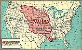
The Louisiana Purchase
Missouri River
The Missouri River flows through the central United States, and is a tributary of the Mississippi River. It is the longest river in North America and drains the third largest area, though only the thirteenth largest by discharge. The Missouri's watershed encompasses most of the American Great...
drainage. The rights to the Louisiana Purchase
Louisiana Purchase
The Louisiana Purchase was the acquisition by the United States of America of of France's claim to the territory of Louisiana in 1803. The U.S...
territory cost the U. S. $15 million, which came out to an average of 3 cents an acre.
The United States Senate
United States Senate
The United States Senate is the upper house of the bicameral legislature of the United States, and together with the United States House of Representatives comprises the United States Congress. The composition and powers of the Senate are established in Article One of the U.S. Constitution. Each...
ratified the treaty on October 20. The following day, it authorized President Jefferson to take possession of the territory and establish a temporary military government. In legislation enacted on October 31, Congress made temporary provisions for local civil government to continue as it had under nominal French and Spanish rule, and authorized the President to use the U.S. Army to maintain order. France then turned New Orleans over to the United States on December 20, 1803. On March 10, 1804, a formal ceremony was conducted in St. Louis, Missouri
St. Louis, Missouri
St. Louis is an independent city on the eastern border of Missouri, United States. With a population of 319,294, it was the 58th-largest U.S. city at the 2010 U.S. Census. The Greater St...
, to transfer ownership of the territory from France to the United States of America.
Lewis and Clark Expedition
The Louisiana Purchase sparked interest in knowing what the nation had actually purchased. President Thomas JeffersonThomas Jefferson
Thomas Jefferson was the principal author of the United States Declaration of Independence and the Statute of Virginia for Religious Freedom , the third President of the United States and founder of the University of Virginia...
, an advocate of exploration and scientific inquiry, had the Congress appropriate $2,500, "to send intelligent officers with ten or twelve men, to explore even to the Western ocean". They were to study, map and record information on the native people, natural history, geology, terrain, and river systems. Jefferson tapped his personal secretary, Meriwether Lewis
Meriwether Lewis
Meriwether Lewis was an American explorer, soldier, and public administrator, best known for his role as the leader of the Lewis and Clark Expedition also known as the Corps of Discovery, with William Clark...
, to lead the expedition, and Lewis recruited William Clark, an experienced soldier and frontiersman who became an equal co-leader of the Lewis and Clark Expedition
Lewis and Clark Expedition
The Lewis and Clark Expedition, or ″Corps of Discovery Expedition" was the first transcontinental expedition to the Pacific Coast by the United States. Commissioned by President Thomas Jefferson and led by two Virginia-born veterans of Indian wars in the Ohio Valley, Meriwether Lewis and William...
The expedition floated up the Missouri River
Missouri River
The Missouri River flows through the central United States, and is a tributary of the Mississippi River. It is the longest river in North America and drains the third largest area, though only the thirteenth largest by discharge. The Missouri's watershed encompasses most of the American Great...
and its larger tributaries, obtained horses from the Shoshone
Shoshone
The Shoshone or Shoshoni are a Native American tribe in the United States with three large divisions: the Northern, the Western and the Eastern....
people to cross the Continental Divide
Continental Divide
The Continental Divide of the Americas, or merely the Continental Gulf of Division or Great Divide, is the name given to the principal, and largely mountainous, hydrological divide of the Americas that separates the watersheds that drain into the Pacific Ocean from those river systems that drain...
, then floated down the Columbia River
Columbia River
The Columbia River is the largest river in the Pacific Northwest region of North America. The river rises in the Rocky Mountains of British Columbia, Canada, flows northwest and then south into the U.S. state of Washington, then turns west to form most of the border between Washington and the state...
to the Pacific Ocean. On the return trip on July 3, 1806 after crossing the Continental Divide, the Corps split into two groups so Lewis could explore and map the Marias River
Marias River
The Marias River is a tributary of the Missouri River, approximately 210 mi long, in the U.S. state of Montana. It is formed in the Blackfeet Indian Reservation in Glacier County, in northwestern Montana, by the confluence of the Cut Bank Creek and the Two Medicine River...
and Clark could do the same on the Yellowstone River
Yellowstone River
The Yellowstone River is a tributary of the Missouri River, approximately long, in the western United States. Considered the principal tributary of the upper Missouri, the river and its tributaries drain a wide area stretching from the Rocky Mountains in the vicinity of the Yellowstone National...
. Between the outbound and homebound portions of the trip, the expedition spent more of its time in what today is Montana than any other place.
On the return trip, Clark signed his name 25 miles (40.2 km) northeast of Billings, Montana
Billings, Montana
Billings is the largest city in the U.S. state of Montana, and is the principal city of the Billings Metropolitan Area, the largest metropolitan area in over...
. The inscription consists of his signature and the date July 25, 1806. Clark claimed he climbed the sandstone pillar now known as Pompey's Pillar
Pompeys Pillar National Monument
Pompeys Pillar National Monument is a rock formation located in south central Montana, United States. Designated a National Monument on January 17, 2001, and managed by the U.S. Bureau of Land Management, it consists of only , making it one of the smallest National Monuments in the U.S...
and "had a most extensive view in every direction on the Northerly Side of the river". Clark named the pillar after Jean Baptiste Charbonneau
Jean Baptiste Charbonneau
Jean Baptiste Charbonneau was an American explorer and guide, fur trapper and trader, military scout during the Mexican-American War, alcalde of Mission San Luis Rey de Francia, and a gold prospector and hotel operator in California. He spoke French and English, and learned German and Spanish...
, nicknamed "Pompy," the son of Sacagawea
Sacagawea
Sacagawea ; was a Lemhi Shoshone woman, who accompanied the Lewis and Clark Expedition, acting as an interpreter and guide, in their exploration of the Western United States...
who was the Shoshone woman who had helped to guide the expedition and, along with her husband Toussaint Charbonneau
Toussaint Charbonneau
Toussaint Charbonneau was a French-Canadian explorer and trader, and a member of the Lewis and Clark Expedition. He is also known as the husband of Sacagawea.-Early years:...
had acted as an interpreter. Clark's original name for the outcropping was "Pompys Tower," but it was later changed to the current title. Clark's inscription is the only remaining physical evidence found along the route that was followed by the expedition.
In the meantime, Lewis' group met some Blackfeet
Blackfeet
The Piegan Blackfeet are a tribe of Native Americans of the Algonquian language family based in Montana, having lived in this area since around 6,500 BC. Many members of the tribe live as part of the Blackfeet Nation in northwestern Montana, with population centered in Browning...
Indians. Their initial meeting was cordial, but during the night, the Blackfeet tried to steal their weapons. In the ensuing struggle, two Indians were killed, the only native deaths attributable to the expedition. To prevent further bloodshed, the group of four—Lewis, Drouillard, and the two Field brothers—fled over 100 miles (160 km) in a day before they camped again. Lewis and Clark rejoined one another at the confluence of the Yellowstone and Missouri Rivers on August 11, 1806. After the two groups were reunited they were able to quickly return to St Louis, Missouri by floating down the Missouri River.
First settlements
St. Mary's Mission was the first permanent white settlement in Montana. Through interactions with Iroquois Indians between 1812 and 1820, the Salish Indians learned about Christianity and Jesuit missionaries (blackrobes) that worked with Indian tribes teaching about agriculture, medicine, and religion. Interest in these “blackrobes” grew among the Salish and, in 1831, four young Salish men were dispatched to St. Louis, Missouri to request a “blackrobe” to return with them to their homeland in the Bitterroot valley. The four Salish men were directed to the home and office of William Clark (of Lewis and Clark fameLewis and Clark Expedition
The Lewis and Clark Expedition, or ″Corps of Discovery Expedition" was the first transcontinental expedition to the Pacific Coast by the United States. Commissioned by President Thomas Jefferson and led by two Virginia-born veterans of Indian wars in the Ohio Valley, Meriwether Lewis and William...
) to make their request. At that time Clark was in charge of administering the territory they called home. Through the perils of their trip, two of the Indians died at the home of General Clark. The remaining two secured a visit with St. Louis Bishop Joseph Rosati
Joseph Rosati
Joseph Rosati was a U.S. Catholic bishop. He served as the first Bishop of the Diocese of Saint Louis between 1826 and 1843....
, who assured them that missionaries would be sent to the Bitterroot Valley
Bitterroot Valley
The Bitterroot Valley is located in southwestern Montana in the northwestern United States. It extends over 100 miles from remote Horse Creek Pass north to a point near the city of Missoula...
when funds and missionaries were available in the future.
Again in 1835 and 1837 the Salish dispatched men to St. Louis to request missionaries but to no avail. Finally in 1839 a group of Iroquois and Salish met Father Pierre-Jean DeSmet in Council Bluffs, Iowa
Council Bluffs, Iowa
Council Bluffs, known until 1852 as Kanesville, Iowathe historic starting point of the Mormon Trail and eventual northernmost anchor town of the other emigrant trailsis a city in and the county seat of Pottawattamie County, Iowa, United States and is on the east bank of the Missouri River across...
. The meeting resulted in Father DeSmet promising to fulfill their request for a missionary the following year.
DeSmet arrived in present-day Stevensville on September 24, 1841, and called the settlement St. Mary’s. Construction of a chapel immediately began, followed by other permanent structures including log cabins and Montana's first pharmacy.
In 1850 Major John Owen arrived in the valley and set up camp north of St. Mary's. In time, Major Owen established a trading post and military strong point named Fort Owen, which served the settlers, Indians, and missionaries in the valley.
Fort Benton
The first permanent fort established in Montana was Fort BentonFort Benton, Montana
Fort Benton is a city in and the county seat of Chouteau County, Montana, United States. A portion of the city was designated as a National Historic Landmark District in 1961. Established a full generation beforethe U.S...
, established as a fur trading post in 1847 and upon being purchased by the US Army in 1865 was named in honor of Senator Thomas Hart Benton
Thomas Hart Benton (senator)
Thomas Hart Benton , nicknamed "Old Bullion", was a U.S. Senator from Missouri and a staunch advocate of westward expansion of the United States. He served in the Senate from 1821 to 1851, becoming the first member of that body to serve five terms...
, who encouraged settlement of the west. Its location on the Missouri River marked the farthest practical point that steamboats could navigate, and thus the Fort quickly grew into a major trading center, promoted today by local residents as "the birthplace of Montana."
Fort Ellis
Built near the mouth of the Gallatin Valley, Fort EllisFort Ellis
Fort Ellis was an early United States Army outpost established August 27, 1867 to the eastern side of present-day Bozeman, Montana. The fort was established to protect and support settlers moving into the Gallatin Valley. The post was named for Civil War Colonel Augustus van Horne Ellis who was...
played an important role in many of the early Indian conflicts in the territory. Elements of the 2nd Cavalry stationed here took part in both the Marias Massacre
Marias Massacre
The Marias Massacre was a massacre of Piegan Blackfeet Indians by the United States Army which took place in Montana during the late nineteenth century Indian Wars.-Background:...
and the Great Sioux War of 1876-77. It also provided a staging location for many missions of exploration and survey into the region that became Yellowstone National Park.
Fort Shaw
Fort ShawFort Shaw, Montana
Fort Shaw is a census-designated place in Cascade County, Montana, United States. The population was 274 at the 2000 census. It is part of the 'Great Falls, Montana Metropolitan Statistical Area'.-Geography:...
was established in the spring of 1867 located west of Great Falls
Great Falls, Montana
Great Falls is a city in and the county seat of Cascade County, Montana, United States. The population was 58,505 at the 2010 census. It is the principal city of the Great Falls, Montana Metropolitan Statistical Area, which encompasses all of Cascade County...
in the Sun River Valley. Two posts built at the time were Camp Cooke on the Judith River
Judith River
The Judith River is a tributary of the Missouri River, approximately 124 mi long, running through central Montana and the United States. It rises in the Little Belt Mountains and flows northeast past Utica and Hobson...
and Fort C.F. Smith on the Bozeman Trail
Bozeman Trail
The Bozeman Trail was an overland route connecting the gold rush territory of Montana to the Oregon Trail. Its most important period was from 1863-1868. The flow of pioneers and settlers through territory of American Indians provoked their resentment and caused attacks. The U.S. Army undertook...
in south central Montana Territory. Fort Shaw was built of adobe and lumber by the 13th Infantry. The fort had a parade ground that was 400 feet (120 m) square, and consisted of barracks for officers, a hospital, and a trading post, and could house up to 450 soldiers. The soldiers mainly guarded the Benton-Helena Road, the major supply-line from Fort Benton
Fort Benton, Montana
Fort Benton is a city in and the county seat of Chouteau County, Montana, United States. A portion of the city was designated as a National Historic Landmark District in 1961. Established a full generation beforethe U.S...
, which was the head of navigation on the Missouri River
Missouri River
The Missouri River flows through the central United States, and is a tributary of the Mississippi River. It is the longest river in North America and drains the third largest area, though only the thirteenth largest by discharge. The Missouri's watershed encompasses most of the American Great...
, to the gold mining districts in southwestern Montana Territory. The fort was decommissioned in 1891 and in 1892 the 20 buildings on the site became Fort Shaw Indian Industrial School. The school boarded young Indians to Americanize them and educate them in modern technology; it had as many as 17 faculty members, 11 Indian assistants, and 300 students.
Montana Territory
After the discovery of gold in the region, Montana became a United States territory (Montana TerritoryMontana Territory
The Territory of Montana was an organized incorporated territory of the United States that existed from May 28, 1864, until November 8, 1889, when it was admitted to the Union as the State of Montana.-History:...
) on May 26, 1864, and the 41st state on November 8, 1889.
 |
 |
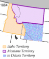 |
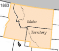
The reorganization of the Idaho Territory in 1864, showing the newly-created Montana Territory. |
Montana territory was organized out of the existing Idaho Territory
Idaho Territory
The Territory of Idaho was an organized incorporated territory of the United States that existed from March 4, 1863, until July 3, 1890, when the final extent of the territory was admitted to the Union as the State of Idaho.-1860s:...
by Act of Congress
United States Congress
The United States Congress is the bicameral legislature of the federal government of the United States, consisting of the Senate and the House of Representatives. The Congress meets in the United States Capitol in Washington, D.C....
and signed into law by President Abraham Lincoln
Abraham Lincoln
Abraham Lincoln was the 16th President of the United States, serving from March 1861 until his assassination in April 1865. He successfully led his country through a great constitutional, military and moral crisis – the American Civil War – preserving the Union, while ending slavery, and...
on May 28, 1864. The areas east of the continental divide
Continental divide
A continental divide is a drainage divide on a continent such that the drainage basin on one side of the divide feeds into one ocean or sea, and the basin on the other side either feeds into a different ocean or sea, or else is endorheic, not connected to the open sea...
had been previously part of the Nebraska
Nebraska Territory
The Territory of Nebraska was an organized incorporated territory of the United States that existed from May 30, 1854, until March 1, 1867, when the final extent of the territory was admitted to the Union as the State of Nebraska. The Nebraska Territory was created by the Kansas–Nebraska Act of 1854...
and Dakota
Dakota Territory
The Territory of Dakota was an organized incorporated territory of the United States that existed from March 2, 1861, until November 2, 1889, when the final extent of the reduced territory was split and admitted to the Union as the states of North and South Dakota.The Dakota Territory consisted of...
territories and had been acquired by the United States in the Louisiana Purchase
Louisiana Purchase
The Louisiana Purchase was the acquisition by the United States of America of of France's claim to the territory of Louisiana in 1803. The U.S...
.
The territory also included land west of the continental divide which had been acquired by the United States in the Oregon Treaty
Oregon Treaty
The Oregon Treaty is a treaty between the United Kingdom and the United States that was signed on June 15, 1846, in Washington, D.C. The treaty brought an end to the Oregon boundary dispute by settling competing American and British claims to the Oregon Country, which had been jointly occupied by...
, and originally included in the Oregon Territory
Oregon Territory
The Territory of Oregon was an organized incorporated territory of the United States that existed from August 14, 1848, until February 14, 1859, when the southwestern portion of the territory was admitted to the Union as the State of Oregon. Originally claimed by several countries , the region was...
. (The part of the Oregon Territory that became part of Montana had been split off as part of the Washington Territory
Washington Territory
The Territory of Washington was an organized incorporated territory of the United States that existed from February 8, 1853, until November 11, 1889, when the final extent of the territory was admitted to the Union as the State of Washington....
.)
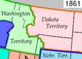
The boundary between the Washington Territory and Dakota Territory
Dakota Territory
The Territory of Dakota was an organized incorporated territory of the United States that existed from March 2, 1861, until November 2, 1889, when the final extent of the reduced territory was split and admitted to the Union as the states of North and South Dakota.The Dakota Territory consisted of...
was the Continental Divide
Continental Divide
The Continental Divide of the Americas, or merely the Continental Gulf of Division or Great Divide, is the name given to the principal, and largely mountainous, hydrological divide of the Americas that separates the watersheds that drain into the Pacific Ocean from those river systems that drain...
(as shown on the 1861 map), however the boundary between the Idaho Territory
Idaho Territory
The Territory of Idaho was an organized incorporated territory of the United States that existed from March 4, 1863, until July 3, 1890, when the final extent of the territory was admitted to the Union as the State of Idaho.-1860s:...
and the Montana Territory followed the Bitterroot Range
Bitterroot Range
The Bitterroot Range runs along the border of Montana and Idaho in the northwestern United States. The range spans an area of 62,736 square kilometers and is named after the bitterroot , a small pink flower that is the state flower of Montana.- History :In 1805, the Corps of Discovery,...
north of 46°30'N (as shown on the 1864 map). Popular legend says a drunken survey party followed the wrong mountain ridge and mistakenly moved the boundary west into the Bitterroot Range.
Contrary to legend, the boundary is precisely where the United States Congress
United States Congress
The United States Congress is the bicameral legislature of the federal government of the United States, consisting of the Senate and the House of Representatives. The Congress meets in the United States Capitol in Washington, D.C....
intended. The Organic Act of the Territory of Montana defines the boundary as extending from the modern intersection of Montana
Montana
Montana is a state in the Western United States. The western third of Montana contains numerous mountain ranges. Smaller, "island ranges" are found in the central third of the state, for a total of 77 named ranges of the Rocky Mountains. This geographical fact is reflected in the state's name,...
, Idaho
Idaho
Idaho is a state in the Rocky Mountain area of the United States. The state's largest city and capital is Boise. Residents are called "Idahoans". Idaho was admitted to the Union on July 3, 1890, as the 43rd state....
, and Wyoming
Wyoming
Wyoming is a state in the mountain region of the Western United States. The western two thirds of the state is covered mostly with the mountain ranges and rangelands in the foothills of the Eastern Rocky Mountains, while the eastern third of the state is high elevation prairie known as the High...
at:
"the forty-fourth degree and thirty minutes of north latitude; thence due west along said forty-fourth degree and thirty minutes of north latitude to a point formed by its intersection with the crest of the Rocky Mountains; thence following the crest of the Rocky Mountains northward till its intersection with the Bitter Root Mountains; thence northward along the crest of the Bitter Root Mountains to its intersection with the thirty-ninth degree of longitude west from Washington; thence along said thirty-ninth degree of longitude northward to the boundary line of the British possessions"
The boundaries of Montana territory did not change during its existence. Montana was admitted to the Union as the state of Montana
Montana
Montana is a state in the Western United States. The western third of Montana contains numerous mountain ranges. Smaller, "island ranges" are found in the central third of the state, for a total of 77 named ranges of the Rocky Mountains. This geographical fact is reflected in the state's name,...
on November 8, 1889.
Battle of the Little Big Horn
The Battle of the Little BighornBattle of the Little Bighorn
The Battle of the Little Bighorn, also known as Custer's Last Stand and, by the Indians involved, as the Battle of the Greasy Grass, was an armed engagement between combined forces of Lakota, Northern Cheyenne and Arapaho people against the 7th Cavalry Regiment of the United States Army...
— which is also called Custer's Last Stand and by Native Americans, the Battle of the Greasy Grass — was an armed engagement between a Lakota (Sioux)-Northern Cheyenne-Arapaho
Arapaho
The Arapaho are a tribe of Native Americans historically living on the eastern plains of Colorado and Wyoming. They were close allies of the Cheyenne tribe and loosely aligned with the Sioux. Arapaho is an Algonquian language closely related to Gros Ventre, whose people are seen as an early...
combined force and the 7th Cavalry
U.S. 7th Cavalry Regiment
The 7th Cavalry Regiment is a United States Army Cavalry Regiment, whose lineage traces back to the mid-19th century. Its official nickname is "Garryowen," in honor of the Irish air Garryowen that was adopted as its march tune....
of the United States Army
United States Army
The United States Army is the main branch of the United States Armed Forces responsible for land-based military operations. It is the largest and oldest established branch of the U.S. military, and is one of seven U.S. uniformed services...
. It occurred June 25–June 26, 1876, near the Little Bighorn River in eastern Montana Territory near present day Hardin, Montana
Hardin, Montana
Hardin is a city in and the county seat of Big Horn County, Montana, United States. The population was 3,384 at the 2000 census.-Geography:Hardin is located at ....
. Lt. Col. George Armstrong Custer
George Armstrong Custer
George Armstrong Custer was a United States Army officer and cavalry commander in the American Civil War and the Indian Wars. Raised in Michigan and Ohio, Custer was admitted to West Point in 1858, where he graduated last in his class...
, with 257 men attacked a much larger force of Native Americans and in three hours was completely annihilated. Only two men from the 7th Cavalry later claimed to have seen Custer engage the Indians: a young Crow whose name translated as Curley
Curley
Ashishishe , known as Curly , was a Crow scout in the United States Army during the Sioux Wars, best known for having been one of the few survivors on the United States side at the Battle of Little Bighorn. He did not fight in the battle, but watched from a distance, and was the first to report the...
, and a trooper named Peter Thompson
Peter Thompson (soldier)
Peter Thompson was a Scots-American soldier who was awarded a Medal of Honor for his actions at the Battle of the Little Bighorn.-Biography:...
, who had fallen behind Custer's column, and most accounts of the last moments of Custer's forces are conjecture. Lakota accounts assert that Crazy Horse
Crazy Horse
Crazy Horse was a Native American war leader of the Oglala Lakota. He took up arms against the U.S...
personally led one of the large groups of Lakota who overwhelmed the cavalry. While exact numbers are difficult to determine, it is commonly estimated that the Northern Cheyenne and Lakota outnumbered the 7th Cavalry by approximately 3:1, a ratio that was extended to 5:1 during the fragmented parts of the battle.
Later, the Sioux were defeated in a series of subsequent battles by the reinforced U.S. Army who continued attacking even in the winter, and most were forced to move onto reservations, mostly outside of Montana, primarily by tactics such as preventing buffalo hunts and enforcing government food-distribution policies to "friendlies" only. The Lakota were compelled to sign a treaty in 1877 ceding the Black Hills
Black Hills
The Black Hills are a small, isolated mountain range rising from the Great Plains of North America in western South Dakota and extending into Wyoming, USA. Set off from the main body of the Rocky Mountains, the region is something of a geological anomaly—accurately described as an "island of...
to the United States, but a low-intensity war continued, culminating, fourteen years later, in the killing of Sitting Bull
Sitting Bull
Sitting Bull Sitting Bull Sitting Bull (Lakota: Tȟatȟáŋka Íyotake (in Standard Lakota Orthography), also nicknamed Slon-he or "Slow"; (c. 1831 – December 15, 1890) was a Hunkpapa Lakota Sioux holy man who led his people as a tribal chief during years of resistance to United States government policies...
(December 15, 1890) at Standing Rock and the Wounded Knee Massacre
Wounded Knee Massacre
The Wounded Knee Massacre happened on December 29, 1890, near Wounded Knee Creek on the Lakota Pine Ridge Indian Reservation in South Dakota, USA. On the day before, a detachment of the U.S. 7th Cavalry Regiment commanded by Major Samuel M...
(December 29, 1890) at Pine Ridge
Pine Ridge Indian Reservation
The Pine Ridge Indian Reservation is an Oglala Sioux Native American reservation located in the U.S. state of South Dakota. Originally included within the territory of the Great Sioux Reservation, Pine Ridge was established in 1889 in the southwest corner of South Dakota on the Nebraska border...
.
Northern Cheyenne exodus
Following the Battle of the Little BighornBattle of the Little Bighorn
The Battle of the Little Bighorn, also known as Custer's Last Stand and, by the Indians involved, as the Battle of the Greasy Grass, was an armed engagement between combined forces of Lakota, Northern Cheyenne and Arapaho people against the 7th Cavalry Regiment of the United States Army...
, attempts by the U.S. Army to capture the Cheyenne intensified. A group of 972 Cheyenne was escorted to Indian Territory
Indian Territory
The Indian Territory, also known as the Indian Territories and the Indian Country, was land set aside within the United States for the settlement of American Indians...
in Oklahoma in 1877. The government intended to re-unite the Northern and Southern Cheyenne into one nation. There the conditions were dire; the Northern Cheyenne were not used to the climate and soon many became ill with malaria
Malaria
Malaria is a mosquito-borne infectious disease of humans and other animals caused by eukaryotic protists of the genus Plasmodium. The disease results from the multiplication of Plasmodium parasites within red blood cells, causing symptoms that typically include fever and headache, in severe cases...
. In addition, the food rations were insufficient and of poor quality. In 1878, the two principal Chiefs, Little Wolf
Little Wolf
Little Wolf was a Northern Cheyenne Chief...
and Morning Star (Dull Knife) pressed for the release of the Cheyenne so they could travel back north. However, they were denied permission, so that same year the two men led a group of 353 Northern Cheyenne who left Indian Territory to travel back north. The Army and other civilian volunteers were in hot pursuit of the Cheyenne as they traveled north. It is estimated that a total of 13,000 Army soldiers and volunteers were sent to pursue the Cheyenne over the whole course of their journey north.
Little Wolf
Little Wolf was a Northern Cheyenne Chief...
, and the other by Dull Knife. Little Wolf and his band made it back to Montana
Montana
Montana is a state in the Western United States. The western third of Montana contains numerous mountain ranges. Smaller, "island ranges" are found in the central third of the state, for a total of 77 named ranges of the Rocky Mountains. This geographical fact is reflected in the state's name,...
. Dull Knife and his band were captured and escorted to Fort Robinson
Fort Robinson
Fort Robinson is a former U.S. Army fort and a present-day state park. Located in the Pine Ridge region of northwest Nebraska, it is west of Crawford on U.S. Route 20.- History :...
, Nebraska
Nebraska
Nebraska is a state on the Great Plains of the Midwestern United States. The state's capital is Lincoln and its largest city is Omaha, on the Missouri River....
and sequestered. They were ordered to return to Oklahoma but they refused. Conditions at the fort grew tense through the end of 1878 and soon the Cheyenne were confined to barracks with no food, water, or heat. In January 1879, Dull Knife and his group broke out of Ft. Robinson. Much of the group was gunned down as they ran away from the fort, and others were discovered near the fort during the following days and ordered to surrender but most of the escapees chose to fight because they would rather be killed than taken back into custody. It is estimated that only 50 survived the breakout, including Dull Knife. Several of the escapees later had to stand trial for the murders that had been committed in Kansas. The remains of those killed were repatriated in 1994.
Ultimately, the military gave up attempting to relocate the Northern Cheyenne in Oklahoma. The persistence of the Northern Cheyenne resulted in the creation of the Northern Cheyenne reservation in Montana.
The flight of the Nez Perce
The Nez Perce people were settled what today is Washington and Oregon, though made hunting forays into western Montana. However, in 1877 pressure from white settlers led to several incidents of violence and a significant number of the Nez Perce were forced from their home region and fled rather than submit to being moved to a reservation. With 2000 U.S. soldiers in pursuit, 800 Nez Perce spent over three months outmaneuvering and battling their pursuers, led by General Howard. They traveled 1700 miles (2,735.9 km) across Oregon, Washington, Idaho, Yellowstone National Park
Yellowstone National Park
Yellowstone National Park, established by the U.S. Congress and signed into law by President Ulysses S. Grant on March 1, 1872, is a national park located primarily in the U.S. state of Wyoming, although it also extends into Montana and Idaho...
, and Montana
Montana
Montana is a state in the Western United States. The western third of Montana contains numerous mountain ranges. Smaller, "island ranges" are found in the central third of the state, for a total of 77 named ranges of the Rocky Mountains. This geographical fact is reflected in the state's name,...
. In the process, they held off the Army at the Battle of the Big Hole
Battle of the Big Hole
The Battle of the Big Hole was a costly battle in the Montana Territory between the Nez Percé and United States army during the Nez Perce War of 1877.-Background:...
in southwestern Montana, dropped into Yellowstone Park, then traveled into east-central Montana where they attempted to ally with both the Crow and the Arapaho, but were rebuffed due to tensions surrounding the aftermath of the Battle of the Little Bighorn. They then turned north, attempting to reach Canada.
General Howard, leading the United States cavalry, was impressed with the skill with which the Nez Perce fought, using advance and rear guards, skirmish lines, and field fortifications. However, unbeknownst to the Nez Perce, a force led by Nelson A. Miles
Nelson A. Miles
Nelson Appleton Miles was a United States soldier who served in the American Civil War, Indian Wars, and the Spanish-American War.-Early life:Miles was born in Westminster, Massachusetts, on his family's farm...
was dispatched from eastern Montana on a quick march to intercept them, which occurred less than 40 miles (60 km) south of Canada in the Bear Paw Mountains
Bear Paw Mountains
The Bear Paw Mountains are an insular-montane island range in North-Central Montana, USA, located approximately 10 miles south of Havre, Montana...
, not far from present-day Chinook
Chinook, Montana
Chinook is a city in and the county seat of Blaine County, Montana, United States. The population was 1,386 at the 2000 census. Points of interest are the Bear Paw Battlefield Museum located in the small town's center and the Bear Paw Battlefield, located just twenty miles south of...
in Blaine County
Blaine County, Montana
-National protected areas:* Black Coulee National Wildlife Refuge* Nez Perce National Historical Park * Upper Missouri River Breaks National Monument -Economy:The main industry in Blaine County is Agriculture...
. Finally, after a devastating five-day battle during freezing weather conditions with no food or blankets, having lost the major war leaders, Chief Joseph formally surrendered
Surrender (military)
Surrender is when soldiers, nations or other combatants stop fighting and eventually become prisoners of war, either as individuals or when ordered to by their officers. A white flag is a common symbol of surrender, as is the gesture of raising one's hands empty and open above one's head.When the...
to General Miles on October 5, 1877.
Louis Riel & the Metis
Some MétisMétis
A Métis is a person born to parents who belong to different groups defined by visible physical differences, regarded as racial, or the descendant of such persons. The term is of French origin, and also is a cognate of mestizo in Spanish, mestiço in Portuguese, and mestee in English...
from the British territory to the north settled in Montana in the latter half of the 19th century. For a time, Louis Riel
Louis Riel
Louis David Riel was a Canadian politician, a founder of the province of Manitoba, and a political and spiritual leader of the Métis people of the Canadian prairies. He led two resistance movements against the Canadian government and its first post-Confederation Prime Minister, Sir John A....
, the Métis leader from Manitoba in exile, taught school at St. Peter's Mission in Montana and was active in the local Republican Party. Democrats alleged he helped Métis men, who were not American citizens, to vote for the Republicans. In the summer of 1884, a delegation of Métis leaders including Gabriel Dumont and James Isbister
James Isbister
James Isbister was a Canadian Métis leader of the 19th-century. Prominent among the Anglo-Métis of the area, he is considered by some to be the founder of the city of Prince Albert, Saskatchewan.-Life:...
, convinced Riel to return north, where in the following year he led the Métis revolt against Canadian rule, known as the Northwest Rebellion. Following the defeat of the Métis rebels and the imprisonment and later hanging to Riel, Gabriel Dumont fled to exile in Montana.
Railroads
The railroads were the engine of settlement in the state. Major development occurred in the 1880s. The Northern Pacific Railroad was given land grants by the federal government so that it could borrow money to build its system, reaching BillingsBillings, Montana
Billings is the largest city in the U.S. state of Montana, and is the principal city of the Billings Metropolitan Area, the largest metropolitan area in over...
in 1882. The federal government kept every other section of land, and gave it away to homesteaders. At first the railroad sold much of its holdings at low prices to land speculators in order to realize quick cash profits, and also to eliminate sizable annual tax bills. The speculators in turn parceled out the land on credit to farmers and ranchers eager to develop operations near a railroad. By 1905 the company changed its land policies as it realize it had been a costly mistake to have sold so much land at wholesale prices. With better railroad service and improved methods of farming the Northern Pacific easily sold what had been heretofore "worthless" land directly to farmers at good prices. By 1910 the railroad's holdings in North Dakota had been greatly reduced. Meanwhile the Great Northern Railroad energetically promoted settlement along its lines in the northern part of the state. The Great Northern bought its lands from the federal government—it received no land grants—and resold them to farmers one by one. It operated agencies in Germany and Scandinavia that promoted its lands, and brought families over at low cost.
The village of Taft, located in western Montana near the Idaho border, was representative of numerous short lived railroad construction camps. In 1907-09 Taft served as a boisterous construction town for the Chicago, Milwaukee, & St. Paul Railroad. The camp included many ethnic groups, numerous saloons and prostitutes, and substantial violence. When construction was finished, the camp was abandoned.
In 1882 the Northern Pacific platted Livingston, Montana
Livingston, Montana
-Geography:Livingston is located at , at an altitude of 4.501 feet .According to the United States Census Bureau, the city has a total area of , of which, of it is land and 0.38% is waters.-Climate:-Demographics:...
, a major division point, repair and maintenance center, and gateway to Yellowstone National Park
Yellowstone National Park
Yellowstone National Park, established by the U.S. Congress and signed into law by President Ulysses S. Grant on March 1, 1872, is a national park located primarily in the U.S. state of Wyoming, although it also extends into Montana and Idaho...
. Built in symmetrical fashion along both sides of the track, the city grew to 7,000 by 1914. Several structures built between 1883 and 1914 still exist and provide a physical record of the era and indicate the city's role as a rail and tourist center. The Northern Pacific depot reflects the desire to impress the tourists who disembarked here for Yellowstone Park, and the railroad's machine shops reveal the city's industrial history.
Women
In Montana, very few single men attempted to operate a farm or ranch; farmers clearly understood the need for a hard-working wife, and numerous children, to handle the many chores, including child-rearing, feeding and clothing the family, managing the housework, feeding the hired hands, and, especially after the 1930s, handling the paperwork and financial detailsEfforts to write woman suffrage into Montana's 1889 constitution failed. Montana women, especially "society women," did not strongly support the suffragists. However, help from national leaders and the efforts of Montana supporters of suffrage such as Jeannette Rankin
Jeannette Rankin
Jeannette Pickering Rankin was the first woman in the US Congress. A Republican, she was elected statewide in Montana in 1916 and again in 1940. A lifelong pacifist, she voted against the entry of the United States into both World War I in 1917 and World War II in 1941, the only member of Congress...
(1880–1973), led to success in 1914 when voters ratified a suffrage amendment passed by the legislature in 1913. In 1916, Rankin, a Republican, became the first woman ever elected to Congress. She was elected again in 1940. Rankin was a peace activist, who voted against American entry into both World War I and World War II.
The status of women in the 19th-century West has drawn the attention of numerous scholars, whose interpretations fall into three types: 1) the Frontier school influenced by Frederick Jackson Turner
Frederick Jackson Turner
Frederick Jackson Turner was an American historian in the early 20th century. He is best known for his essay "The Significance of the Frontier in American History", whose ideas are referred to as the Frontier Thesis. He is also known for his theories of geographical sectionalism...
, which argues that the West was a liberating experience for women and men; 2) the reactionists, who view the West as a place of drudgery for women, who reacted unfavorably to the isolation and the work in the West; and 3) those writers who claim the West had no effect on women's lives, that it was a static, neutral frontier. Cole (1990) uses legal records to argue that Turner thesis best explains the improvement in women's status in Montana and the early achievement of suffrage.
Women's clubs expressed the interests, needs, and beliefs of middle class women at the turn of the century. While accepting the domestic role established by the cult of domesticity
Cult of Domesticity
The Cult of Domesticity or Cult of True Womanhood was a prevailing value system among the upper and middle classes during the nineteenth century in the United States and Great Britain. Although all women were supposed to emulate this ideal of womanhood, it was assumed that only white women could...
, their reformist activities reveal a persistent demand for self-expression outside the home. Homesteading was a significant experience for altering women's perceptions of their roles. They expressed their aesthetic interests in gardens, and organized social activities. Though these clubs allowed women to fulfill their traditional roles they also encouraged women to pursue social, intellectual, and community interests. Women took an active role in the Progressive Movement, especially in battles for suffrage, prohibition, better schools, church activities, charity work, and crime reduction.
Childbirth was serious and sometimes life threatening for rural women well into the 20th century. Although large families were favored by farm families, most women employing birth control methods to space their children and limit their family size. Pregnant women had little access to modern knowledge about prenatal care. Delivery was the big gamble; the great majority gave birth at home, with the services of a midwife or an experienced neighbor. Despite the increased availability of hospital care after the 1920s, modern medical benefits to mitigate the danger of childbirth were not available to most rural Montana women until the World War II era.
Agricultural history
Cattle ranching has long been central to Montana's history and economy. Cattle ranching came early to Montana with the entrepreneurship of Johnny Grant in the Deer Lodge Valley in the late 1850s, who traded fat cattle to settlers in exchange for two trail-worn (but otherwise healthy) animals. He later sold his ranch to Conrad Kohrs, who developed a major cattle empire in the area. Today, the core homestead is the Grant-Kohrs Ranch National Historic SiteGrant-Kohrs Ranch National Historic Site
Established by Canadian fur trader Johnny Grant, and expanded by cattle baron Conrad Kohrs, Grant-Kohrs Ranch National Historic Site commemorates the Western cattle industry from its 1850s inception through recent times. The park was created in 1972, and embraces 1,500 acres and 90 structures. The...
on the edge of Deer Lodge
Deer Lodge, Montana
Deer Lodge is a city in and the county seat of Powell County, Montana, United States. The population was 3,421 at the 2000 census. The city is perhaps best known as the home of the Montana State Prison, a major local employer...
, and is maintained as a link to the ranching style of the late 19th century. It is operated by the National Park Service
National Park Service
The National Park Service is the U.S. federal agency that manages all national parks, many national monuments, and other conservation and historical properties with various title designations...
but is also a 1,900 acre (7.7 km²) working ranch.
In 1866 Nelson Story brought the first herd of Texas longhorn
Texas longhorn (cattle)
The Texas Longhorn is a breed of cattle known for its characteristic horns, which can extend to tip to tip for steers and exceptional cows, and tip to tip for bulls. Horns can have a slight upward turn at their tips or even triple twist. Texas Longhorns are known for their diverse coloring...
s up from Texas. Additional herds came into Montana east of the divide and initially expanded greatly on the open range. However, cattle ranching expanded beyond the carrying capacity of the land, and a drought year combined with the harsh winter of 1886-1887 decimated Montana's cattle industry. The ranchers who survived began to fence in their ranches and the era of the open range
Open range
Open range may refer to: vast areas of grassy land that is owned by the federal government.*Rangeland, vast natural landscapes*Open Range, the 2003 Western movie co-starring, co-produced, and directed by Kevin Costner...
came to an end.
By 1908, the open range that had sustained Native American tribes and government-subsidized cattle barons was pockmarked with small ranchers and struggling farmers. The revised Homestead Act
Homestead Act
A homestead act is one of three United States federal laws that gave an applicant freehold title to an area called a "homestead" – typically 160 acres of undeveloped federal land west of the Mississippi River....
of the early 1900s greatly affected the settlement of Montana. This act expanded the land that was provided by the Homestead Act of 1862 from 160 acre (0.6474976 km²) to 320 acres (65-130 ha). When the latter act was signed by President William Taft
William Howard Taft
William Howard Taft was the 27th President of the United States and later the tenth Chief Justice of the United States...
, it also reduced the time necessary to prove up from five years to three years and permitted five months absence from the claim each year.
In 1908, the Sun River Irrigation Project, west of Great Falls
Great Falls, Montana
Great Falls is a city in and the county seat of Cascade County, Montana, United States. The population was 58,505 at the 2010 census. It is the principal city of the Great Falls, Montana Metropolitan Statistical Area, which encompasses all of Cascade County...
was opened up for homesteading. Similar irrigation projects developed in many other Montana communities. Under this Reclamation Act, a person could obtain 40 acres (16 ha). Most of the people who came to file on these homesteads were young couples who were eager to live near the mountains where hunting and fishing were good. Many of these homesteaders came from the Midwest and Minnesota
Minnesota
Minnesota is a U.S. state located in the Midwestern United States. The twelfth largest state of the U.S., it is the twenty-first most populous, with 5.3 million residents. Minnesota was carved out of the eastern half of the Minnesota Territory and admitted to the Union as the thirty-second state...
.
Farming was further encouraged by the railroads. Wheat farming started slowly in Montana, only replacing oats as the major grain crop after development of new plant strains, techniques, and machinery. Wheat was stimulated by boom prices in World War I, but slumped in value and yield during the drought and depression of the next 20 years. Beginning in 1905, the Great Northern Railway in cooperation with the US Department of Agriculture, the Montana Experiment Station, and the Dryland Farming Congress promoted dryland farming in Montana in order to increase its freight traffic. During 1910-13 the Great Northern launched its own program of demonstration farms, which stimulated settlement (during 1909-10 acreage in homesteads quadrupled in Montana) through their impressive production rates for winter wheat, barley, oats and other grains. As a result of the promotion the land along the Milk River, the northern tier, better known as the "hi-line," was settled in 1900-15. In an area better suited to grazing cattle, inexperienced newcomers locally called "Honyockers" undertook to grow wheat, and met some early success when ample rainfall and high prices were the rule. For several years after 1918, droughts and hot winds destroyed the crops, bringing severe hardships and driving out all but the most determined of the settlers. Much of the land was acquired by stockmen, who have turned it back to grazing cattle.
Entrepreneurs
Henry Sieben (1847–1937) came to Montana's gold fields in 1864, was a farm laborer, prospector, and freighter, then turned to livestock raising along the Smith River in 1870. In partnership with his brothers he raised cattle and became one of the territory's pioneer sheep ranchers in 1875. In 1879 Henry moved his stock to the Lewistown area. He established a reputation as an excellent businessman and as someone who took care of his stock and employees. After ranching in the Culbertson area, Sieben purchased ranches near Cascade and along Little Prickly Pear Creek, forming the Sieben Livestock Company. By 1907, these two ranches had become the heart of his cattle and sheep raising business which he directed from his home in Helena. Sieben became well known for his business approach to ranching and for his public and private philanthropies. His family continues to operate the Sieben Ranch Company today, and one of his descendants is United States Senator Max Sieben BaucusMax Baucus
Max Sieben Baucus is the senior United States Senator from Montana and a member of the Democratic Party. First elected to the Senate in 1978, as of 2010 he is the longest-serving Senator from Montana, and the fifth longest-serving U.S...
.
After seeing the falls of the Missouri River in central Montana, Paris Gibson
Paris Gibson
Paris Gibson was an American entrepreneur and politician.Gibson was born in Brownfield, Maine. An 1851 graduate of Bowdoin College, he served as a member of the Montana State Senate and as a Democratic member of the United States Senate between 1901 and 1905.-Career:In 1853 he was elected to the...
(1830–1920) decided the location presented an ideal site for a town. Founding Great Falls, Montana
Great Falls, Montana
Great Falls is a city in and the county seat of Cascade County, Montana, United States. The population was 58,505 at the 2010 census. It is the principal city of the Great Falls, Montana Metropolitan Statistical Area, which encompasses all of Cascade County...
, in 1884, Gibson was inspired by a grandiose vision of an economically prosperous city that was also beautiful. He took an active role in the development of Great Falls, as well as Montana as a whole, making his voice heard on issues from dryland farming to the humane treatment of animals. While many of his visionary ideals have long since been passed by, his efforts at community building in the West serve as a unique example and provide an important perspective on the region's continuing development.
The Conrad families built a substantial banking business in north-central and northwestern Montana during the late 19th and early 20th centuries. Banking houses at Fort Benton, Great Falls, and Kalispell, owned and managed by the families of William Conrad and Charles Conrad helped to finance Montana's economic development through an intricate pattern of familial, friendship, and business ties. Correspondent linkages to large metropolitan banks sustained the relatively small country banks by assuring them access to capital. The Conrad banks were aggressive in penetrating new lending markets and making inroads into the local farming, ranching, merchant, and manufacturing sectors. The banks grew in reputation and stature as the region developed, but remained single-unit, family-based enterprises. But Conrad's expanded across the international border into Alberta
Alberta
Alberta is a province of Canada. It had an estimated population of 3.7 million in 2010 making it the most populous of Canada's three prairie provinces...
through the Conrad Circle Cattle Company.
Banking in Montana was a high risk business, as the 1920s demonstrated. Between 1921 and 1925 half of the state's 428 banks closed. There was an excessive number of small, weak banks in the grain-growing areas of Eastern Montana where the postwar slump wiped out land values and related loans.
Montana's history was heavily dominated by its "Copper Kings." Marcus Daly
Marcus Daly
Marcus Daly redirects here, see also Marcus Daly Marcus Daly was an Irish-born American businessman known as one of the three "Copper Kings" of Butte, Montana, United States.- Early life:...
(1841–1900), an Irish immigrant, left a legacy of physical structures throughout Montana. Starting with his development of the Alice mine in Butte, he then founded the community of Anaconda where he built a smelter. Butte, with its mixture of poor miners' shacks, richly ornamented homes, mines, and mills, symbolized industrial mining. At Anaconda, the company town, the great Washoe Stack smelted the ore from Butte, bringing immense wealth to the region but also spewed pollutants that left the landscape downwind of the smelter wasted and barren. Daly's lumber mill at Bonner dominated the town. In the agricultural community of Hamilton
Hamilton, Montana
Hamilton is a city in and the county seat of Ravalli County, Montana, United States. The population was 3,705 at the 2000 census. Significant outlying population growth is shown in the area; the ZIP Code Tabulation Area for Hamilton's ZIP Code, 59840, had a population of 12,327at the 2000 census.-...
, Daly built the 20000 acres (80.9 km²) Bitterroot Stock Farm with its, complete with racetrack and mansion. His arch rival, W.A. Clark
William Andrews Clark
William Andrews Clark, Sr. was an American politician and entrepreneur, involved with mining, banking, and railroads.-Biography:...
, invested heavily in the Butte mines and parlayed his influence into the political arena, engineering the selection of Helena
Helena, Montana
Helena is the capital city of the U.S. state of Montana and the county seat of Lewis and Clark County. The 2010 census put the population at 28,180. The local daily newspaper is the Independent Record. The Helena Brewers minor league baseball and Helena Bighorns minor league hockey team call the...
over Anaconda as the state capitol. He later was elected as Montana's U.S. Senator under circumstances of such corruption that his antics provided one of the incentives for the Constitutional amendment allowing direct election of senators.
Simon Pepin (1840–1914), the "Father of Havre," was born in Quebec in 1840, emigrated to Montana in 1863, and became a contractor furnishing supplies for the construction of forts Custer, Assiniboine, and Maginnis. Pepin purchased ranch lands near Fort Assiniboine. When James J. Hill
James J. Hill
James Jerome Hill , was a Canadian-American railroad executive. He was the chief executive officer of a family of lines headed by the Great Northern Railway, which served a substantial area of the Upper Midwest, the northern Great Plains, and Pacific Northwest...
built the Great Northern Railway across northern Montana, Pepin convinced him to build his locomotive shops at Havre
Havre, Montana
Havre is a city in, and the county seat of, Hill County, Montana, United States. It is said to be named after the city of Le Havre in France. The population was 9,621 at the 2000 census.-History:...
, on property owned by Pepin. In the ensuing years, Pepin was a major contributor to Havre's economic growth through his cattle, real estate, and banking enterprises.
Many entrepreneurs built stores, shops, and offices along Main Street. The most handsome ones used pre-formed, sheet iron facades, especially those manufactured by the Mesker Brothers of St. Louis. These neoclassical, stylized facades added sophistication to brick or woodframe buildings throughout the state.
Retail business
In the rural areas farmers and ranchers depended on general stores that had a limited stock and slow turnover; they made enough profit to stay in operation by selling at high prices. Prices were not marked on each item; instead the customer negotiated a price. Men did most of the shopping, since the main criteria was credit rather than quality of goods. Indeed, most customers shopped on credit, paying off the bill when crops or cattle were later sold; the business owner's ability to judge credit worthiness was vital to his success.In the cities consumers had more choices, usually purchasing dry goods and supplies at locally owned department stores such as Helena's T.C. Power & Bro, which expanded into several cities, I.G. Baker & Co. in Fort Benton, Strain Bros. of Great Falls, F.A. Buttrey & Co. in Havre, and others. They had a much wider selection of goods than in the country general stores and price tags that gave the actual selling price. Department stores provided limited credit, and set up attractive displays and, after 1900, window displays as well. Their clerks—usually men before the 1940s—were experienced salesmen whose knowledge of the products appealed to the better educated middle-class women who did most of the shopping. The keys to success were a large variety of high-quality brand-name merchandise, high turnover, reasonable prices, and frequent special sales. The larger stores sent their buyers to Denver, Minneapolis, and Chicago once or twice a year to evaluate the newest trends in merchandising and stock up on the latest fashions. By the 1920s and 1930s, large mail-order houses such as Sears, Roebuck & Co. and Montgomery Ward provided serious competition, so the department stores came to rely even more on salesmanship as well as close integration with the community.
Butte
Copper made ButteButte, Montana
Butte is a city in Montana and the county seat of Silver Bow County, United States. In 1977, the city and county governments consolidated to form the sole entity of Butte-Silver Bow. As of the 2010 census, Butte's population was 34,200...
one of the most prosperous cities in the world, due to deposits dubbed "the Richest Hill on Earth". From 1892 through 1903, the Anaconda mine in Butte was the largest copper-producing mine in the world. It produced more than $300 million worth of metal in its lifetime. The nearby city of Anaconda
Anaconda, Montana
Anaconda, county seat of Anaconda City/Deer Lodge County, is located in mountainous southwestern Montana. The Continental Divide passes within 8 miles of the community with the local Pintler Mountain range reaching 10,379 feet...
was the dream child of industrialist Marcus Daly
Marcus Daly
Marcus Daly redirects here, see also Marcus Daly Marcus Daly was an Irish-born American businessman known as one of the three "Copper Kings" of Butte, Montana, United States.- Early life:...
(1841–1900), whose Anaconda Copper Mining Company (ACM) by 1900 employed three-quarters of Montana's wage earners; it dominated the state's politics and press into the 1950s. The smelters in Anaconda process the copper mined in Butte. From 1884 to 1934, the Company fought industrial unionism; finally in 1901 workers there organized a local of the radical Western Federation of Miners
Western Federation of Miners
The Western Federation of Miners was a radical labor union that gained a reputation for militancy in the mines of the western United States and British Columbia. Its efforts to organize both hard rock miners and smelter workers brought it into sharp conflicts – and often pitched battles...
(WFM). In 1916, the WFM became the International Union of Mine, Mill, and Smelter Workers (IUMMSW), one of the ten original unions of the Congress of Industrial Organizations
Congress of Industrial Organizations
The Congress of Industrial Organizations, or CIO, proposed by John L. Lewis in 1932, was a federation of unions that organized workers in industrial unions in the United States and Canada from 1935 to 1955. The Taft-Hartley Act of 1947 required union leaders to swear that they were not...
(CIO) in the 1930s. However, the union remained weak until 1934, when members joined with miners, other smelter workers, and some craft laborers in the region in a strike that forced the Company to negotiate. In the late 1940s the CIO purged unions controlled by Communists, which meant the expulsion of the IUMMSW and a bid for influence among smelter workers by the anticommunist United Steel Workers of America (USWA). In 1980, most of the copper mines and smelters were shut down, leaving a major cleanup mess for the Environmental Protection Agency.
Butte was one of the largest cities west of the Mississippi for generations. Silver Bow county (Butte and suburbs)
Silver Bow County, Montana
-National protected areas:*Beaverhead National Forest *Deerlodge National Forest -Demographics:As of the census of 2000, there were 34,606 people, 14,432 households, and 8,933 families residing in the county. The population density was 48 people per square mile . There were 16,176 housing units at...
had 24,000 people in 1890, and peaked at 60,000 in 1920. Then the population steadily declined to 34,000 in 1990 and stabilized. In its heyday between the late 19th century and about 1920, it was the largest and most notorious copper boomtown
Boomtown
A boomtown is a community that experiences sudden and rapid population and economic growth. The growth is normally attributed to the nearby discovery of a precious resource such as gold, silver, or oil, although the term can also be applied to communities growing very rapidly for different reasons,...
s in the American West, home to hundreds of saloons and a famous red-light district
Red-light district
A red-light district is a part of an urban area where there is a concentration of prostitution and sex-oriented businesses, such as sex shops, strip clubs, adult theaters, etc...
. The documentary Butte, America
Butte, America
Butte, America is a 2009 documentary film about Butte, Montana's history as a copper mining town. It was created by Pamela Roberts, narrated by Gabriel Byrne, and includes a mix of first hand accounts and scholarly analysis from John T. Shea, Marie Cassidy, David Emmons, and Janet Finn...
depicts its history as a copper producer and the issues of labor unionism, economic rise and decline, and environmental degradation that resulted from the activity.
Mining camps
Many mining camps were established in the late 19th century, some becoming established cities like Butte and Red LodgeRed Lodge, Montana
Red Lodge is a city in and the county seat of Carbon County, Montana, United States. It is part of the Billings, Montana Metropolitan Statistical Area...
which survived the closure of their mines. Others enjoyed a boom period then withered away, though some, such as Bannack
Bannack, Montana
Bannack is a ghost town in Beaverhead County, Montana, United States, located on Grasshopper Creek, approximately upstream from where Grasshopper Creek joins with the Beaverhead River south of Dillon.-History:...
have since become famed as "ghost towns" and have been preserved. Another example was the community of Comet, in what today is Jefferson County, where there were mines and processing mills from 1869 to 1941. At its height, Comet was a town of 12 blocks and 6 streets and by 1911 had extracted $13 million worth of metals (gold, silver, lead, zinc, and copper ore), but is now abandoned and decaying. The town's most prominent remains are the mill, office, and bunkhouse, which are leftovers from the last productive years in the 1920s and 1930s. Most of the other structures and buildings have collapsed from neglect.
Anaconda
Metals manufacturing dominated life in four Montana communities - Anaconda, Black Eagle (a suburb of Great Falls), East Helena, and Columbia Falls. The industrial workers who lived in the shadow of the smokestacks faced health hazards and job insecurity. Wives often worked to supplement the family income and after 1960 women increasingly worked outside the home. The smelters, usually the only workplace for young men who wished to remain in the community, created blue-collar towns. Residents expressed a love-hate relationship with the companies, which paid high wages for semi-skilled workers and supported community projects but were heavy-handed with the workers. Labor unions united the community workers and local business.In 1903, the Socialist Party of America
Socialist Party of America
The Socialist Party of America was a multi-tendency democratic-socialist political party in the United States, formed in 1901 by a merger between the three-year-old Social Democratic Party of America and disaffected elements of the Socialist Labor Party which had split from the main organization...
won its first victory west of the Mississippi when Anaconda, Montana
Anaconda, Montana
Anaconda, county seat of Anaconda City/Deer Lodge County, is located in mountainous southwestern Montana. The Continental Divide passes within 8 miles of the community with the local Pintler Mountain range reaching 10,379 feet...
, elected a socialist mayor, treasurer, police judge, and three councilmen. The Socialist Party had grown within the Montana labor movement. Initially, the Anaconda Copper Mining Company tolerated them, but when the Socialists gained political power and threatened to implement reform, particularly when a socialist mayor was also elected in Butte, the company systematically undermine the Socialists. City workers and councilmen refused to cooperate with the new mayor, and the company began to fire Socialists. In the long run labor lost ground in Anaconda and the company exerted ever greater political control.
Timber
Timber resources were critical to both mines and railroads. Western Montana had ample timber but not always along the most natural railroad routes, and timber near mines was quickly depleted. Thus huge swaths of timber resources were made available to private railroad and mining interests, usually in a checkerboard pattern of ownership intersperced with sections of publicly-held land. The communities of Libby, Kalispell and Missoula rose in part due to the demand for timber and their location along strategic waterways.Coal
Montana holds significant coal reserves and strip mining became the most economically feasible method by which to extract coal. Major coal deposits were located near the southeastern Montana settlements of Birney and Decker, and mining soon replaced cattle ranching in the immediate area. The small community of ColstripColstrip, Montana
Colstrip is a city in Rosebud County, Montana, United States. The population was 2,346 at the 2000 census. Established in 1924 and incorporated as a city in 1998, Colstrip is the largest city in Rosebud County with 25% of the total population. Colstrip's primary industries are coal mining and...
grew substantially as it became the site for several major coal-fired power plants associated at the time with Western Energy, a subsidiary of the Montana Power Company
Montana Power Company
The Montana Power Company was an electric utility company based in Butte, Montana which provided electricity to Montana consumers and industry from 1912 to 1997.- History :...
. For residents of the region, the characteristic sense of community disappeared. The physical damage to the environment was an important factor as was the influx of miners who then outnumbered the original population. Most damaging, however, was the strife between pro- and anti-development factions in the community. Most of the inhabitants of small towns like Decker, convinced their old lifestyle had been destroyed, moved elsewhere. Residents around Birney, farther from the site of strip mining, remained divided on whether the changes had improved their quality of life. The entire state had considerable political uproar during the 1970s when the coal-fired generation plants around Colstrip first came online, resulting in the formation of major environmental organizations such as the Northern Plains Resource Council
Northern Plains Resource Council
The Northern Plains Resource Council is an environmental lobbying organization based in Montana. It was founded in 1972 to lobby for stricter environmental controls on coal mining and coal fired power plants.-External Links:**...
the passage of Montana's Environmental Protection Act (MEPA) and the Major Facilities Siting Act.
Oil
Texaco operated a pipeline from Canada that went through Glendive in the early 1950s. After the discovery of oil in the Williston BasinWilliston Basin
The Williston Basin is a large intracratonic sedimentary basin in eastern Montana, western North and South Dakota, and southern Saskatchewan known for its rich deposits of petroleum and potash. The basin is a geologic structural basin but not a topographic depression; it is transected by the...
, communities such as Glendive
Glendive, Montana
Glendive is a city in and the county seat of Dawson County, Montana, United States. The population was 4,935 at the 2010 census.The town of Glendive is located in South Eastern Montana and is considered by many as an agricultural hub of Eastern Montana...
became an oil boom town. The small reserves of the basin, coupled with the expense and difficulty of moving the oil out of the area, brought the end of the oil boom in Glendive in 1954. In the 1970s, new discoveries, combined with international fluctuations in the oil industry, created a second boom centered around the community of Sidney
Sidney, Montana
Sidney is a city in and the county seat of Richland County, Montana, United States, less than away from the North Dakota border. The population was 5,191 at the 2010 census. The city lies along the Yellowstone River and is in proximity to the badlands of the Dakotas...
. This boom also faded.
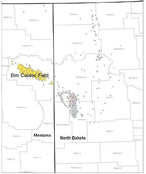
Directional drilling
Directional drilling is the practice of drilling non-vertical wells. It can be broken down into three main groups: Oilfield Directional Drilling, Utility Installation Directional Drilling Directional drilling (or slant drilling) is the practice of drilling non-vertical wells. It can be broken down...
and fracturing technology, made it financially attractive to drill very deep new wells in the Bakken Formation of the Williston Basin. The discovery in 2000 of the extremely rich Elm Coulee Oil Field
Elm Coulee Oil Field
Elm Coulee Oil Field was discovered in the Williston Basin in Richland County, eastern Montana, in 2000. It produces oil from the Bakken Formation and, as of 2007, is the "highest-producing onshore field found in the lower 48 states in the past 56 years." By 2007, the field had become one...
near Sidney in Richland County
Richland County, Montana
-Demographics:As of the census of 2000, there were 9,667 people, 3,878 households, and 2,652 families residing in the county. The population density was 5 people per square mile . There were 4,557 housing units at an average density of 2 per square mile...
--with a potential for many billions of barrels of oil—and the high price of oil has created a new regional boom in the 21st century.
Hydropower
The development of electrical power led to demand for electricity. The combination of Montana's abundant rivers combined with ready availability of natural resources for transporting electricity led to the building of multiple dams across the state, particularly a number on the Missouri River, most owned and operated by the Montana Power Company. The city of Great Falls, due to the presence of several existing natural cascades, became a center for hydropower development.Politics
Montana politics historically were noted for the tendency of Montanans to vote independently, with split ticket voting common and for races to be likely to fall to either major political party, though certain regions of the state more predictably fell into one partisan camp or the other. At times it was said that Montana "sent its liberals to Washington and its conservatives to [the state capitol] Helena." The state, considering its relatively brief history, produced a number of notable and colorful political figures, including Democrats Thomas Francis MeagherThomas Francis Meagher
-Young Ireland:Meagher returned to Ireland in 1843, with undecided plans for a career in the Austrian army, a tradition among a number of Irish families. In 1844 he traveled to Dublin with the intention of studying for the bar. He became involved in the Repeal Association, which worked for repeal...
, William Andrews Clark
William Andrews Clark
William Andrews Clark, Sr. was an American politician and entrepreneur, involved with mining, banking, and railroads.-Biography:...
, Thomas J. Walsh
Thomas J. Walsh
Thomas James Walsh was a lawyer and Democratic Party politician from Helena, Montana, in the United States.-Background:...
, Burton K. Wheeler
Burton K. Wheeler
Burton Kendall Wheeler was an American politician of the Democratic Party and a United States Senator from 1923 until 1947.-Early life:...
, James E. Murray, and Mike Mansfield
Mike Mansfield
Michael Joseph Mansfield was an American Democratic politician and the longest-serving Majority Leader of the United States Senate, serving from 1961 to 1977. He also served as United States Ambassador to Japan for over ten years...
; and Republicans Jeannette Rankin
Jeannette Rankin
Jeannette Pickering Rankin was the first woman in the US Congress. A Republican, she was elected statewide in Montana in 1916 and again in 1940. A lifelong pacifist, she voted against the entry of the United States into both World War I in 1917 and World War II in 1941, the only member of Congress...
and Joseph M. Dixon.
Joseph Dixon
Joseph M. DixonJoseph M. Dixon
Joseph Moore Dixon was a Republican politician from Montana. He served as a Representative, Senator, and the seventh Governor of Montana. A businessman and a modernizer of Quaker heritage, Dixon was a leader of the Progressive Movement in Montana and nationally...
(1867–1934), was a Republican politician from Missoula
Missoula, Montana
Missoula is a city located in western Montana and is the county seat of Missoula County. The 2010 Census put the population of Missoula at 66,788 and the population of Missoula County at 109,299. Missoula is the principal city of the Missoula Metropolitan Area...
. He served as a Representative, Senator
United States Senate
The United States Senate is the upper house of the bicameral legislature of the United States, and together with the United States House of Representatives comprises the United States Congress. The composition and powers of the Senate are established in Article One of the U.S. Constitution. Each...
, and the seventh Governor of Montana. A businessman and a modernizer of Quaker heritage, Dixon was a leader of the Progressive Movement in Montana and nationally in 1912, serving as national campaign manager or Theodore Roosevelt's unsuccessful third term candidacy for president. His term as governor, 1921–1924, was unsuccessful, as severe economic hardship limited the opportunities to enact his proposed reforms in state government, and his great enemy the Anaconda Copper
Anaconda Copper
Anaconda Copper Mining Company was one of the largest trusts of the early 20th century. The Anaconda was purchased by Atlantic Richfield Company on January 12, 1977...
company mobilized its resources to defeat his reelection bid in 1924.
James Murray
James E. Murray (1876–1961) was born in Ontario, Canada, but when his father died he was taken in by a wealthy uncle in Butte, who owned copper mines. Murray, an Irish Catholic, practiced law in Butte and was active in the Democratic Party, working closely with labor unions to build his political base. In 1921, he inherited millions from his late uncle, dabbled in Irish politics, and reentered Montana politics when the Great DepressionGreat Depression in the United States
The Great Depression began with the Wall Street Crash of October, 1929 and rapidly spread worldwide. The market crash marked the beginning of a decade of high unemployment, poverty, low profits, deflation, plunging farm incomes, and lost opportunities for economic growth and personal advancement...
soured the Montana economy in the 1930s. When Senator Walsh resigned to enter Roosevelts Cabinet in 1933, John Erickson the Democratic governor had himself appointed to the slot, despite his weak political base. Murray defeated Erickson in the 1934 primary, and was elected senator on the platform of "one hundred per-cent support" of President Roosevelt. He served until 1960, becoming a powerful senior senator. Murray was a staunch liberal and aggressive supporter of the New Deal Coalition
New Deal coalition
The New Deal Coalition was the alignment of interest groups and voting blocs that supported the New Deal and voted for Democratic presidential candidates from 1932 until the late 1960s. It made the Democratic Party the majority party during that period, losing only to Dwight D. Eisenhower in 1952...
. Murray broke with the senior senator Wheeler when Murray backed Roosevelt's attempt to pack the Supreme Court in 1937; unlike Wheeler, Murray gave up his isolationism in foreign affairs, and backed Roosevelt's aggressive foreign policy against Germany and Japan in 1939-1941. After the war, the conservatives controlled Congress, so Murray had little success with his proposals to expand Social Security, provided free medical care for the aged, expand federal aid to education, or create a Missouri Valley Authority with the federal control over Montana's water resources patterned after the Tennessee Valley Authority
Tennessee Valley Authority
The Tennessee Valley Authority is a federally owned corporation in the United States created by congressional charter in May 1933 to provide navigation, flood control, electricity generation, fertilizer manufacturing, and economic development in the Tennessee Valley, a region particularly affected...
. Instead, Congress adopted the Pick-Sloan Plan with flood control by the Army Corps of Engineers, the Bureau of Reclamation, and private development.
The Murray Hotel
The Murray Hotel
The Murray Hotel, originally named the Elite Hotel, is an historic hotel in Livingston, Montana, United States. The original two story hotel was built at the corner of Park and Second St. in 1904 by Josephine Kline to accommodate passengers from the Northern Pacific Railway...
in Livingston, Montana
Livingston, Montana
-Geography:Livingston is located at , at an altitude of 4.501 feet .According to the United States Census Bureau, the city has a total area of , of which, of it is land and 0.38% is waters.-Climate:-Demographics:...
was financed by the Murray family and named for the senator.
As Chairman of the Interior and Insular Affairs Committee in the 1950s, Murray was more successful in promoting federal development of hydroelectric power through large dams throughout the West. He secured funding for large dams in Montana at Canyon Ferry on the Missouri River
Missouri River
The Missouri River flows through the central United States, and is a tributary of the Mississippi River. It is the longest river in North America and drains the third largest area, though only the thirteenth largest by discharge. The Missouri's watershed encompasses most of the American Great...
, Yellowtail on the Bighorn River
Bighorn River
The Bighorn River is a tributary of the Yellowstone, approximately long, in the western United States in the states of Wyoming and Montana. The river was named in 1805 by fur trader François Larocque for the Bighorn Sheep he saw along its banks as he explored the Yellowstone River.The upper...
, Hungry Horse on the Flathead River
Flathead River
The Flathead River, in the northwestern part of the U.S. state of Montana, originates in the Rocky Mountains near Glacier National Park and flows southwest into Flathead Lake, then after a journey of , empties into the Clark Fork. The river is part of the Columbia River drainage basin, as the Clark...
, and Libby on the Kootenai River.
Recent trends
Since the 1970s, the western third of the state has grown and attracted tourists, retirees, and up-scale part-time residents seeking spectacular mountain scenery as well as an interest in outdoor recreational activities, including hiking, hunting and fishing. Housing prices soared, but then declined sharply in the Great recession of 2008. Simultaneously the shift to a postmodern service economy has led to growth in service-oriented cities such as BillingsBillings, Montana
Billings is the largest city in the U.S. state of Montana, and is the principal city of the Billings Metropolitan Area, the largest metropolitan area in over...
(with medicine and the energy industry) in the eastern part of the state, and in the western half, Missoula
Missoula, Montana
Missoula is a city located in western Montana and is the county seat of Missoula County. The 2010 Census put the population of Missoula at 66,788 and the population of Missoula County at 109,299. Missoula is the principal city of the Missoula Metropolitan Area...
(with higher education). Cities such as Bozeman
Bozeman, Montana
Bozeman is a city in and the county seat of Gallatin County, Montana, United States, in the southwestern part of the state. The 2010 census put Bozeman's population at 37,280 making it the fourth largest city in the state. It is the principal city of the Bozeman micropolitan area, which consists...
and Kalispell
Kalispell, Montana
Kalispell is a city in and the county seat of Flathead County, Montana, United States. The 2010 census put Kalispell's population at 19,927 up 5,704 over 2000. At 40.1% this is the largest percentage of growth of any incorporated city in Montana. Kalispell is the largest city and commercial center...
saw significant growth related to tourism. Meanwhile, the populations of older mining centers such as Butte and Anaconda shrunk. After ARCO
ARCO
Atlantic Richfield Company is an oil company with operations in the United States as well as in Indonesia, the North Sea, and the South China Sea. It has more than 1,300 gas stations in the western part of the United States. ARCO was originally formed by the merger of East Coast-based Atlantic...
shut down the Anaconda copper operations in 1980, its former mines and smelter became the Environmental Protection Agency's second largest Superfund cleanup site.
Most of the small towns in the eastern half of the state steadily lost population as younger people move out. However in the Bakken oil region there are boom town conditions in towns such as Sidney. Billings has been growing and serves as a transportation, refining, financial and technical center for the booming oil and coal industries, as well as ranching and farming.
Interpretations
Newspaperman and author Joseph Kinsey HowardJoseph Kinsey Howard
Joseph Kinsey Howard was an American journalist, historian, and author, who wrote extensively about the history, culture, and economic circumstances of Montana...
(1906–51) believed Montana and the rural West provided the "last stand against urban technological tedium" for the individual. He fervently believed that small towns of the sort that predominated in Montana provided a democratic bulwark for society. Howard's writings demonstrate his strong belief in the necessity to identify and preserve a region's cultural heritage. His history of the state Montana: High, Wide and Handsome (1943), as well as numerous speeches and magazine articles, were based on his ideals of community awareness and identity, his hatred of the Anaconda Company, and called on readers to retain an idealistic vision contesting the deadening demands of the modern corporate world.
Surveys
- Hamilton, James McClellan. From Wilderness to Statehood: A History of Montana, 1805-1900 (Bindfords & Mort, 1957) 627pp; textbook; online edition
- Howard, Joseph Kinsey. Montana: High, Wide, and Handsome (1943; with new forward, University of Nebraska Press, 2003) online, the standard scholarly history
- WPA Federal Writers Project. Montana: A State Guide Book (Viking Press, 1939) classic guide to history, culture and every town online edition
Local studies
- Van West; Carroll. Capitalism on the Frontier: Billings and the Yellowstone Valley in the Nineteenth Century (University of Nebraska Press, 1993) online edition
- Hedges, James B. "The Colonization Work of the Northern Pacific Railroad," Mississippi Valley Historical Review Vol. 13, No. 3 (Dec., 1926), pp. 311–342 in JSTOR
- Jensen, Vernon H. Heritage of Conflict: Labor Relations in the Nonferrous Metals Industry up to 1930 (Cornell University Press, 1950) online edition
Politics
- Lemon, Greg. Blue Man in a Red State: Montana's Governor Brian Schweitzer and the New Western Populism (2008), popular
- O'Keane, Josephine. Thomas J. Walsh: A Senator from Montana(1955) online edition.
- Spritzer, Donald F. Senator James E. Murray and the Limits of Post-War Liberalism (1985).
- Swibold, Dennis L. Copper chorus: mining, politics, and the Montana press, 1889-1959 (2006)
- Waldron, Ellis L. Montana politics since 1864: an atlas of elections (1958) 428 pages
See also
- Notable figures in Montana historyNotable figures in Montana historyThis is a list of notable figures in the history of pre-territorial Montana, Montana Territory and the state of Montana. Individuals listed played significant roles in the exploration and settlement of the region as well as the cultural, economic, military and political development of the...
- History of the Western United States
- Montana in the American Civil WarMontana in the American Civil WarMontana played little direct role in the American Civil War. The closest the Confederate States Army ever came to Montana was New Mexico and eastern Kansas, each over a thousand miles away...
- Territorial evolution of Montana