
Chain of Rocks Bridge
Encyclopedia
- This article is about the bridge built in 1929 which used to carry U.S. Route 66, and currently carries pedestrian and bicycle traffic. For the bridge built in 1966 which carries I-270 traffic, see New Chain of Rocks BridgeNew Chain of Rocks BridgeThe New Chain of Rocks Bridge is a pair of bridges across the Mississippi River on the north edge of St. Louis, Missouri. It was constructed in 1966 to bypass the Chain of Rocks Bridge immediately to the south. It originally carried traffic for Bypass US 66 and currently carries traffic for...
.
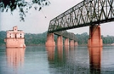
The Chain of Rocks Bridge spans the Mississippi River
Mississippi River
The Mississippi River is the largest river system in North America. Flowing entirely in the United States, this river rises in western Minnesota and meanders slowly southwards for to the Mississippi River Delta at the Gulf of Mexico. With its many tributaries, the Mississippi's watershed drains...
on the north edge of St. Louis, Missouri
St. Louis, Missouri
St. Louis is an independent city on the eastern border of Missouri, United States. With a population of 319,294, it was the 58th-largest U.S. city at the 2010 U.S. Census. The Greater St...
. The eastern end of the bridge is on Chouteau Island
Chouteau Island
Chouteau Island , situated approximately due north of the St. Louis, Missouri Gateway Arch and approximately south of the confluence of the Missouri River and Mississippi River, is one of a cluster of three islands: Chouteau, Gabaret, and Mosenthein. The three, with a combined area of...
, (part of Madison, Illinois
Madison, Illinois
Madison is a city in Madison County and partially in St. Clair County, Illinois, United States. The population was 4,545 at the 2000 census. It is home to Gateway International Raceway and the first Bulgarian Orthodox church in the United States.-Geography:...
), while the western end is on the Missouri
Missouri
Missouri is a US state located in the Midwestern United States, bordered by Iowa, Illinois, Kentucky, Tennessee, Arkansas, Oklahoma, Kansas and Nebraska. With a 2010 population of 5,988,927, Missouri is the 18th most populous state in the nation and the fifth most populous in the Midwest. It...
shoreline.
The bridge was for a time the route used by U.S. Route 66
U.S. Route 66
U.S. Route 66 was a highway within the U.S. Highway System. One of the original U.S. highways, Route 66 was established on November 11, 1926 -- with road signs erected the following year...
to cross over the Mississippi. Its most notable feature is a 22-degree bend occurring at the middle of the crossing. Originally a motor route, the bridge now carries walking and biking trails over the river. The bridge was added to the National Register of Historic Places
National Register of Historic Places
The National Register of Historic Places is the United States government's official list of districts, sites, buildings, structures, and objects deemed worthy of preservation...
in 2006.
The bridge's name comes from a large shoal, or rocky rapids, called the Chain of Rocks, which made that stretch of the Mississippi extremely dangerous to navigate. Because of a low-water dam built by the Corps of Engineers in the 1960s, little of the Chain of Rocks is visible today except during extreme low water conditions. After 1940, only a single impediment prevented the maintenance of a safe and reliable 9 feet (2.7 m) navigation channel on the Mississippi River from St. Paul, Minnesota, to New Orleans. This impediment, known as the Chain of Rocks Reach, was a 17 miles (27.4 km) series of rock ledges that began just north of St. Louis and was extremely difficult and dangerous to navigate. In the late 1940s and early 1950s the U.S. Army Corps of Engineers built a 8.4 miles (13.5 km) long canal to bypass this treacherous reach. To ensure adequate depths in the pool below the old Lock and Dam 26, a non-movable, low water dam was constructed just below the north end of the canal and a lock was installed at the south end of the canal. Known respectively as Dam No. 27, a.k.a. Chain of Rocks Dam, and Locks No. 27, a.k.a. Chain of Rocks Lock
Chain of Rocks Lock
Chain of Rocks Lock, also known as Locks #27, is a lock situated on the southern end of Chouteau Island near St. Louis, Missouri on the Upper Mississippi River...
.
History
The area was chosen as a site for the St. Louis waterworks in 1865, with construction beginning in 1887, and the water plant opened in 1894. A filter plant was added in 1915, which at the time of its construction was the largest filter plant in the world. The Chain of Rocks bridge was privately built as a toll bridge in 1929 at a cost of $3 million and later turned over to the city of Madison, IllinoisMadison, Illinois
Madison is a city in Madison County and partially in St. Clair County, Illinois, United States. The population was 4,545 at the 2000 census. It is home to Gateway International Raceway and the first Bulgarian Orthodox church in the United States.-Geography:...
, the current owner of the bridge. Though engineers predicted ten fatalities during the creation of the bridge, only one worker, was killed. In the late 1930s, bypass U.S. 66 was designated over this bridge and around the northern and western parts of St. Louis to avoid the downtown area (city U.S. 66 continued to cross the Mississippi River over the MacArthur Bridge
MacArthur Bridge (St. Louis)
The MacArthur Bridge over the Mississippi River between St. Louis, Missouri and East St. Louis, Illinois is a 647 foot long truss bridge. Construction on the bridge was begun in 1909 by the city of St. Louis to break the Terminal Railroad Association of St. Louis's monopoly on the area's railroad...
). On August 2, 1966, the tolls were suspended by the city of Madison, which marked an end of the struggle with the state of Missouri over tolls. In 1966, the New Chain of Rocks Bridge
New Chain of Rocks Bridge
The New Chain of Rocks Bridge is a pair of bridges across the Mississippi River on the north edge of St. Louis, Missouri. It was constructed in 1966 to bypass the Chain of Rocks Bridge immediately to the south. It originally carried traffic for Bypass US 66 and currently carries traffic for...
was built immediately to the bridge's north in order to carry I-270
Interstate 270 (Illinois-Missouri)
Interstate 270 makes up a large portion of the outer belt freeway in the St. Louis, Missouri metropolitan area. The counterclockwise terminus of I-270 is at the junction with Interstate 55 in Mehlville, Missouri; the clockwise terminus of the freeway is at the junction with I-55 and I-70 north of...
; the Chain of Rocks Bridge was subsequently closed on February 25, 1970.
For nearly three decades the fate of the bridge was uncertain, though demolition seemed its most likely end. The high cost of demolition, however, indefinitely delayed that outcome until a new use was found. During this time, the bridge developed a reputation for crime and violence, including the April 1991 murder of sisters Julie and Robin Kerry
Marlin Gray
Marlin A. Gray was convicted of on two counts of first-degree murder and executed by the U.S. state of Missouri by lethal injection...
. It was used as a filming site for Escape from New York
Escape from New York
Escape from New York is a 1981 American science fiction action film directed and scored by John Carpenter. He co-wrote the screenplay with Nick Castle. The film is set in the near future in a crime-ridden United States that has converted Manhattan Island in New York City into a maximum security...
in 1981, with the bridge being used as the "69th Street Bridge".
In 1998, the bridge was leased to Trailnet, a local trails group, to operate.http://www.trailnet.org/p_ocorb.php Four-and-a-half million dollars have been spent on renovating the bridge for pedestrian and cycling use.http://www.mobikefed.org/2005_10_01_newsarchive.php
From the Illinois side of the bridge, signs marked "HISTORIC ROUTE 66 SPUR" take travelers to the Illinois side of the bridge and a "HISTORIC ROUTE 66" sign marks the Missouri side of the bridge. The Gateway Arch
Gateway Arch
The Gateway Arch, or Gateway to the West, is an arch that is the centerpiece of the Jefferson National Expansion Memorial in St. Louis, Missouri. It was built as a monument to the westward expansion of the United States...
is visible downriver, and immediately downstream from the bridge, two water intakes for the St. Louis Waterworks are visible (see Gallery). One is vaguely Gothic Revival in style; the other closely echoes Roman ruins from Trier
Trier
Trier, historically called in English Treves is a city in Germany on the banks of the Moselle. It is the oldest city in Germany, founded in or before 16 BC....
in modern Germany.