

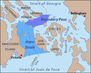
Boundary Pass
Encyclopedia
Strait
A strait or straits is a narrow, typically navigable channel of water that connects two larger, navigable bodies of water. It most commonly refers to a channel of water that lies between two land masses, but it may also refer to a navigable channel through a body of water that is otherwise not...
that runs for about 23 kilometres (14.3 mi) along the boundary between the U.S. state
U.S. state
A U.S. state is any one of the 50 federated states of the United States of America that share sovereignty with the federal government. Because of this shared sovereignty, an American is a citizen both of the federal entity and of his or her state of domicile. Four states use the official title of...
of Washington and the Canadian province
Canada
Canada is a North American country consisting of ten provinces and three territories. Located in the northern part of the continent, it extends from the Atlantic Ocean in the east to the Pacific Ocean in the west, and northward into the Arctic Ocean...
of British Columbia
British Columbia
British Columbia is the westernmost of Canada's provinces and is known for its natural beauty, as reflected in its Latin motto, Splendor sine occasu . Its name was chosen by Queen Victoria in 1858...
. It connects Haro Strait
Haro Strait
Haro Strait, often referred to as the Haro Straits because it is really a series of straits, is one of the main channels connecting the Strait of Georgia to the Strait of Juan de Fuca, separating Vancouver Island and the Gulf Islands in British Columbia, Canada from the San Juan Islands of...
to the south with the Strait of Georgia
Strait of Georgia
The Strait of Georgia or the Georgia Strait is a strait between Vancouver Island and the mainland coast of British Columbia, Canada. It is approximately long and varies in width from...
to the north.
The USGS
United States Geological Survey
The United States Geological Survey is a scientific agency of the United States government. The scientists of the USGS study the landscape of the United States, its natural resources, and the natural hazards that threaten it. The organization has four major science disciplines, concerning biology,...
defines its northern boundary as a line extending from East Point on Saturna Island
Saturna Island
Saturna Island is a mountainous island, about 31 km² in size, in the Southern Gulf Islands chain of British Columbia. It is situated approximately midway between the Lower Mainland of B.C. and Vancouver Island, and is the most easterly of the Gulf Islands. It is surrounded on three sides by...
to Alden Point on Patos Island
Patos Island
Patos Island is a small island in the San Juan Islands of the U.S. state of Washington. Since 1893, it has been home to the Patos Island Lighthouse, guiding vessels through Boundary Pass between Canada and the United States....
. Its southeastern boundary is a line from Alden Point on Patos Island to Point Hammond on Waldron Island then from Sandy Point on Waldron Island to Charles Point on Stuart Island
Stuart Island (Washington)
Stuart Island is one of the San Juan Islands in Washington state, USA, north of San Juan Island and west of Waldron Island. The island is home to two communities of full and part-time residents, a state park, a one-room schoolhouse, and two airstrips .The 2000 census...
. Its southwestern boundary is a line connecting Turn Point on Stuart Island to Point Fairfax on Moresby Island. Its western boundary is a line running from Pelorus Point on Moresby Island to Wallace Point on North Pender Island
Pender Island
Pender Island is one of the Southern Gulf Islands located in the Gulf of Georgia, British Columbia, Canada. Pender Island is approximately in area and is home to about 2,500 permanent residents, as well as a large seasonal population...
then to Tilly Point on South Pender Island then from Teece Point on South Pender Island to Taylor Point on Saturna Island.