
Óc Eo
Encyclopedia
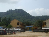
Óc Eo is an archaeological site in Thoại Sơn District in southern An Giang Province
, Vietnam
, in the Mekong River Delta region of Vietnam. It is also one of the modern day communes of Vietnam
. Óc Eo may have been a busy port of the kingdom of Funan between the 1st and 7th centuries AD. Scholars use the term "Óc Eo Culture" to refer to the ancient material culture
of the Mekong Delta region that is typified by the artifacts recovered at Óc Eo through archeological investigation.
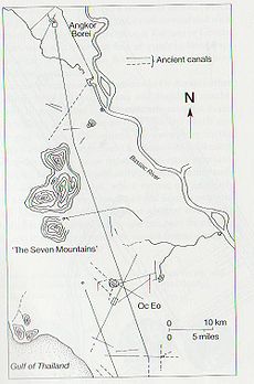
Óc Eo is situated within a network of ancient canals that crisscross the low flatland of the Mekong Delta
. One of the canals connects Óc Eo to the town's seaport while another goes 42 miles north-northeast to Angkor Borei. Óc Eo is longitudinally bisected by a canal, and there are four transverse canals along which pile-supported houses were perhaps ranged.
Archeological sites reflecting the material culture of Óc Eo are spread throughout southern Vietnam, but are most heavily concentrated in the area of the Mekong Delta to the south and west of Ho Chi Minh City
. The most significant site, aside from Óc Eo itself, is at Tháp Muời north of the Tien Giang River, where among other remains a stele with a 6th-century Sanskrit
text has been discovered.
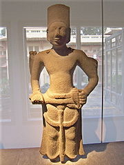 The remains found at Óc Eo include pottery, tools, jewelry, casts for making jewelry, coins (including coins from the Roman Empire
), and religious statues. Many of the remains have been collected and are on exhibition in Museum of Vietnamese History
in Ho Chi Minh City
.
of Funan.
The Vietnamese historian Ha Van Tan has questioned whether the vestiges excavated at Óc Eo belonged to Funan, in view of the complete lack of any Khmer
records relating to a kingdom of this name: he argues that Óc Eo gradually emerged as an economic and cultural centre of the Mekong Delta and, with an important position on the Southeast Asian sea routes, became a meeting place for craftsmen and traders, which provided adequate conditions for urbanization, receiving foreign influences which in turn stimulated internal development.
 Óc Eo may have been the port known to the Romans as Kattigara. Kattigara was the name given by the 2nd century AD Alexandrian geographer Claudius Ptolemy to the land on the easternmost shore of the Mare Indicum at (due to a scribal error) eight and a half degrees South of the Equator
. Scholarship has now determined that Ptolemy's Kattigara was at eight and a half degrees North of the Equator, and was the forerunner of Saigon.
John Caverhill deduced in 1767 that Cattigara was the Mekong Delta port Banteaymeas (now Hà Tiên
), not far from Óc Eo. The plea in 1979 by Jeremy H.C.S. Davidson for “a thorough study of Hà-tiên in its historical context and in relation to Óc-eo” as indispensable for accurate understanding and interpretation of the site, still remains unanswered.
The name "Kattigara" was probably derived from the Sanskrit Kirti-nagara “Renowned City” or Kotti-nagara “Strong City”. The “father of Early Southeast Asian History”, George Coedès, has said: “By the middle of the 3rd century Fu-nan had already established relations with China and India, and it is doubtless on the west coast of the Gulf of Siam that the furthest point reached by Hellenistic navigators is to be found, that is the harbour of Kattigara mentioned by Ptolemy”. Judging from the sailing directions given by the seafarer Alexander, Bjorn Landström concluded that Cattigara lay at the mouth of the Mekong. A.H. Christie said in 1979 that “the presence of objects, however few in number, from the Roman Orient” added some weight to the conjecture that Óc-eo was the Ptolemaic Kattigara. The distinguished German classical scholar, Albrecht Dihle, supported this view, saying:
Guided by Ptolemy, the discoverers of the New World were initially trying to find their way to Kattigara. On the 1489 map of the world made by Henricus Martellus Germanus
, based on Ptolemy’s work, Asia terminated in its southeastern point in a cape, the Cape of Cattigara. Writing of his 1499 voyage, Amerigo Vespucci
said he had hoped to reach Malacca
(Melaka) by sailing westward from Spain across the Western Ocean (the Atlantic
) around the Cape of Cattigara into the Sinus Magnus, the Great Gulf that lay to the East of the Golden Chersonese (Malay Peninsula
), of which the Cape of Cattigara formed the southeastern point. The Sinus Magnus, or Great Gulf, was the actual Gulf of Thailand
.
, on his fourth and last voyage of 1502-1503, planned to follow the coast of Champa
southward around the Cape of Cattigara and sail through the strait separating Cattigara from the New World, into the Sinus Magnus to Malacca. This was the route he thought Marco Polo
had gone from China to India in 1292. Columbus planned to meet up with the expedition sent at the same time from Portugal
around the Cape of Good Hope
under Vasco da Gama
, and carried letters of credence from the Spanish monarchs to present to da Gama. On reaching Cariay on the coast of Costa Rica
, Columbus thought he was close the gold mines of Champa. On July 7, 1503, he wrote from Jamaica
: “I reached the land of Cariay…Here I received news of the gold mines of Ciamba [Champa] which I was seeking”.
An Giang Province
An Giang is a province of Vietnam. It is located in the Mekong Delta, in the southwestern part of the country, sharing a border with Cambodia to the northwest.- Geography :...
, Vietnam
Vietnam
Vietnam – sometimes spelled Viet Nam , officially the Socialist Republic of Vietnam – is the easternmost country on the Indochina Peninsula in Southeast Asia. It is bordered by China to the north, Laos to the northwest, Cambodia to the southwest, and the South China Sea –...
, in the Mekong River Delta region of Vietnam. It is also one of the modern day communes of Vietnam
Communes of Vietnam
In Vietnam, there are three kinds of third-level administrative subdivisions: the rural commune , the commune-level town ,and the ward . In Vietnam a rural commune is referred to as a xã and urban communes are referred to as Thị trấn, urban townships...
. Óc Eo may have been a busy port of the kingdom of Funan between the 1st and 7th centuries AD. Scholars use the term "Óc Eo Culture" to refer to the ancient material culture
Material culture
In the social sciences, material culture is a term that refers to the relationship between artifacts and social relations. Studying a culture's relationship to materiality is a lens through which social and cultural attitudes can be discussed...
of the Mekong Delta region that is typified by the artifacts recovered at Óc Eo through archeological investigation.
The Archeological Site
Excavation at Óc Eo began on February 10, 1942 after French archaeologists had discovered the site through the use of aerial photography. The first excavations were led by Louis Mallaret. The site covers 450 ha.Óc Eo is situated within a network of ancient canals that crisscross the low flatland of the Mekong Delta
Mekong Delta
The Mekong Delta is the region in southwestern Vietnam where the Mekong River approaches and empties into the sea through a network of distributaries. The Mekong delta region encompasses a large portion of southwestern Vietnam of . The size of the area covered by water depends on the season.The...
. One of the canals connects Óc Eo to the town's seaport while another goes 42 miles north-northeast to Angkor Borei. Óc Eo is longitudinally bisected by a canal, and there are four transverse canals along which pile-supported houses were perhaps ranged.
Archeological sites reflecting the material culture of Óc Eo are spread throughout southern Vietnam, but are most heavily concentrated in the area of the Mekong Delta to the south and west of Ho Chi Minh City
Ho Chi Minh City
Ho Chi Minh City , formerly named Saigon is the largest city in Vietnam...
. The most significant site, aside from Óc Eo itself, is at Tháp Muời north of the Tien Giang River, where among other remains a stele with a 6th-century Sanskrit
Sanskrit
Sanskrit , is a historical Indo-Aryan language and the primary liturgical language of Hinduism, Jainism and Buddhism.Buddhism: besides Pali, see Buddhist Hybrid Sanskrit Today, it is listed as one of the 22 scheduled languages of India and is an official language of the state of Uttarakhand...
text has been discovered.
The Remains
Roman Empire
The Roman Empire was the post-Republican period of the ancient Roman civilization, characterised by an autocratic form of government and large territorial holdings in Europe and around the Mediterranean....
), and religious statues. Many of the remains have been collected and are on exhibition in Museum of Vietnamese History
Museum of Vietnamese History
The Museum of Vietnamese History is located at 2 Nguyen Binh Khiem Street, Ben Nghe Ward, District 1, in Ho Chi Minh City, Vietnam. Formerly known as "Musée Blanchard de la Brosse" and "The National Museum of Viet Nam in Sai Gon", it received its current name in 1979. It is a museum showcasing...
in Ho Chi Minh City
Ho Chi Minh City
Ho Chi Minh City , formerly named Saigon is the largest city in Vietnam...
.
Óc Eo and Funan
Óc Eo has been regarded as belonging to the historical kingdom of Funan (扶南) that flourished in the Mekong Delta between the 1st and the 6th century CE. The kingdom of Funan is known to us from the works of ancient Chinese historians, especially writers of dynastic histories, who in turn drew from the testimony of Chinese diplomats and travellers, and of foreign (including Funanese) embassies to the Chinese imperial courts. Indeed, the name "Funan" itself is an artifact of the Chinese histories, and does not appear in the paleographic record of ancient Vietnam or Cambodia. From the Chinese sources, however, it can be determined that a polity called "Funan" by the Chinese was the dominant polity located in the Mekong Delta region. As a result, archeological discoveries in that region that can be dated to the period of Funan have been identified with the historical polity of Funan. The discoveries at Óc Eo and related sites are our primary source for the material cultureMaterial culture
In the social sciences, material culture is a term that refers to the relationship between artifacts and social relations. Studying a culture's relationship to materiality is a lens through which social and cultural attitudes can be discussed...
of Funan.
The Vietnamese historian Ha Van Tan has questioned whether the vestiges excavated at Óc Eo belonged to Funan, in view of the complete lack of any Khmer
Cambodia
Cambodia , officially known as the Kingdom of Cambodia, is a country located in the southern portion of the Indochina Peninsula in Southeast Asia...
records relating to a kingdom of this name: he argues that Óc Eo gradually emerged as an economic and cultural centre of the Mekong Delta and, with an important position on the Southeast Asian sea routes, became a meeting place for craftsmen and traders, which provided adequate conditions for urbanization, receiving foreign influences which in turn stimulated internal development.
Oc Eo as the Kattigara of Ptolemy
Equator
An equator is the intersection of a sphere's surface with the plane perpendicular to the sphere's axis of rotation and containing the sphere's center of mass....
. Scholarship has now determined that Ptolemy's Kattigara was at eight and a half degrees North of the Equator, and was the forerunner of Saigon.
John Caverhill deduced in 1767 that Cattigara was the Mekong Delta port Banteaymeas (now Hà Tiên
Hà Tiên
Hà Tiên or Ha Tien is a town in Kien Giang Province, Tay Nam Bo of Vietnam. Area: 8,851.5 ha, population : 39,957. The town borders Cambodia to the west....
), not far from Óc Eo. The plea in 1979 by Jeremy H.C.S. Davidson for “a thorough study of Hà-tiên in its historical context and in relation to Óc-eo” as indispensable for accurate understanding and interpretation of the site, still remains unanswered.
The name "Kattigara" was probably derived from the Sanskrit Kirti-nagara “Renowned City” or Kotti-nagara “Strong City”. The “father of Early Southeast Asian History”, George Coedès, has said: “By the middle of the 3rd century Fu-nan had already established relations with China and India, and it is doubtless on the west coast of the Gulf of Siam that the furthest point reached by Hellenistic navigators is to be found, that is the harbour of Kattigara mentioned by Ptolemy”. Judging from the sailing directions given by the seafarer Alexander, Bjorn Landström concluded that Cattigara lay at the mouth of the Mekong. A.H. Christie said in 1979 that “the presence of objects, however few in number, from the Roman Orient” added some weight to the conjecture that Óc-eo was the Ptolemaic Kattigara. The distinguished German classical scholar, Albrecht Dihle, supported this view, saying:
From the account of the voyage of Alexander referred to by Ptolemy, Kattigara can actually be located only in the Mekong delta, because Alexander went first along the east coast of the Malacca peninsula, northward to Bangkok, from thence likewise only along the coast toward the south east, and so came to Kattigara. We hear nothing of any further change of course. In addition, at Oc Eo, an emporium excavated in the western Mekong delta, in the ancient kingdom of Fu-nan, Roman finds from the 2nd century after Christ have come to light.
Guided by Ptolemy, the discoverers of the New World were initially trying to find their way to Kattigara. On the 1489 map of the world made by Henricus Martellus Germanus
Henricus Martellus Germanus
Henricus Martellus Germanus is the latinized name of Heinrich Hammer, a German cartographer who lived and worked in Florence from 1480 to 1496....
, based on Ptolemy’s work, Asia terminated in its southeastern point in a cape, the Cape of Cattigara. Writing of his 1499 voyage, Amerigo Vespucci
Amerigo Vespucci
Amerigo Vespucci was an Italian explorer, financier, navigator and cartographer. The Americas are generally believed to have derived their name from the feminized Latin version of his first name.-Expeditions:...
said he had hoped to reach Malacca
Malacca
Malacca , dubbed The Historic State or Negeri Bersejarah among locals) is the third smallest Malaysian state, after Perlis and Penang. It is located in the southern region of the Malay Peninsula, on the Straits of Malacca. It borders Negeri Sembilan to the north and the state of Johor to the south...
(Melaka) by sailing westward from Spain across the Western Ocean (the Atlantic
Atlantic Ocean
The Atlantic Ocean is the second-largest of the world's oceanic divisions. With a total area of about , it covers approximately 20% of the Earth's surface and about 26% of its water surface area...
) around the Cape of Cattigara into the Sinus Magnus, the Great Gulf that lay to the East of the Golden Chersonese (Malay Peninsula
Malay Peninsula
The Malay Peninsula or Thai-Malay Peninsula is a peninsula in Southeast Asia. The land mass runs approximately north-south and, at its terminus, is the southern-most point of the Asian mainland...
), of which the Cape of Cattigara formed the southeastern point. The Sinus Magnus, or Great Gulf, was the actual Gulf of Thailand
Gulf of Thailand
The Gulf of Thailand , also known in to Malays as Teluk Siam literally meant Gulf of Siam, is a shallow arm of the South China Sea.-Geography:...
.
Columbus' search for Ciamba
Christopher ColumbusChristopher Columbus
Christopher Columbus was an explorer, colonizer, and navigator, born in the Republic of Genoa, in northwestern Italy. Under the auspices of the Catholic Monarchs of Spain, he completed four voyages across the Atlantic Ocean that led to general European awareness of the American continents in the...
, on his fourth and last voyage of 1502-1503, planned to follow the coast of Champa
Champa
The kingdom of Champa was an Indianized kingdom that controlled what is now southern and central Vietnam from approximately the 7th century through to 1832.The Cham people are remnants...
southward around the Cape of Cattigara and sail through the strait separating Cattigara from the New World, into the Sinus Magnus to Malacca. This was the route he thought Marco Polo
Marco Polo
Marco Polo was a Venetian merchant traveler from the Venetian Republic whose travels are recorded in Il Milione, a book which did much to introduce Europeans to Central Asia and China. He learned about trading whilst his father and uncle, Niccolò and Maffeo, travelled through Asia and apparently...
had gone from China to India in 1292. Columbus planned to meet up with the expedition sent at the same time from Portugal
Portugal
Portugal , officially the Portuguese Republic is a country situated in southwestern Europe on the Iberian Peninsula. Portugal is the westernmost country of Europe, and is bordered by the Atlantic Ocean to the West and South and by Spain to the North and East. The Atlantic archipelagos of the...
around the Cape of Good Hope
Cape of Good Hope
The Cape of Good Hope is a rocky headland on the Atlantic coast of the Cape Peninsula, South Africa.There is a misconception that the Cape of Good Hope is the southern tip of Africa, because it was once believed to be the dividing point between the Atlantic and Indian Oceans. In fact, the...
under Vasco da Gama
Vasco da Gama
Vasco da Gama, 1st Count of Vidigueira was a Portuguese explorer, one of the most successful in the Age of Discovery and the commander of the first ships to sail directly from Europe to India...
, and carried letters of credence from the Spanish monarchs to present to da Gama. On reaching Cariay on the coast of Costa Rica
Costa Rica
Costa Rica , officially the Republic of Costa Rica is a multilingual, multiethnic and multicultural country in Central America, bordered by Nicaragua to the north, Panama to the southeast, the Pacific Ocean to the west and the Caribbean Sea to the east....
, Columbus thought he was close the gold mines of Champa. On July 7, 1503, he wrote from Jamaica
Jamaica
Jamaica is an island nation of the Greater Antilles, in length, up to in width and 10,990 square kilometres in area. It is situated in the Caribbean Sea, about south of Cuba, and west of Hispaniola, the island harbouring the nation-states Haiti and the Dominican Republic...
: “I reached the land of Cariay…Here I received news of the gold mines of Ciamba [Champa] which I was seeking”.
Sources
- Albert Herrmann, “Der Magnus Sinus und Cattigara nach Ptolemaeus”, Comptes Rendus du 15me Congrès International de Géographie, Amsterdam, 1938, Leiden, Brill, 1938, tome II, sect. IV, Géographie Historique et Histoire de la Géographie, pp. 123–8.
- Albert Herrmann, Das Land der Seide und Tibet in Lichte der Antike, Leipzig, 1938, pp. 80, 84.
- Louis Malleret, L’Archéologie du delta du Mékong, Tome Troisiéme, La culture du Fu-nan, Paris, 1962, chap.XXV, “Oc-Èo et Kattigara”, pp. 421–54.
- John Caverhill, “Some Attempts to ascertain the utmost Extent of the Knowledge of the Ancients in the East Indies”, Philosophical Transactions, vol.57, 1767, pp. 155–174.
- Adhir K. Chakravarti, “Early Sino-Indian Maritime Trade and Fu-Nan”, D.C. Sircar (ed.), Early Indian Trade and Industry, Calcutta, University of Calcutta Centre of Advanced Study in Ancient Indian History and Culture, Lectures and Seminars, no.VIII-A, part I, 1972, pp. 101–117.
- George Cœdès, “Fouilles en Cochinchine: Le Site de Go Oc Eo, Ancien Port du Royaume de Fou-nan”, Artibus Asiae, vol.10, no.3, 1947, pp. 193–199.
- George Coedès, review of Paul Wheatley, The Golden Khersonese (Kuala Lumpur, 1961), in T'oung Pao 通報, vol.49, parts 4/5, 1962, pp. 433–439.
- George Coedès, “Some Problems in the Ancient History of the Hinduized States of South-East Asia”, Journal of Southeast Asian History, vol.5, no.2, September 1964, pp. 1–14.
- Albrecht Dihle, “Serer und Chinesen”, in Antike und Orient: Gesammelte Aufsätze, Heidelberg, Carl Winter, 1984, S.209.
- J.W. McCrindle, Ancient India as described by Ptolemy, London, Trubner, 1885, revised edition by Ramachandra Jain, New Delhi, Today & Tomorrow’s Printers & Publishers, 1974, p. 204:
- George E. Nunn, ‘The Three Maplets attributed to Bartholomew Columbus’, Imago Mundi, 9 (1952), 12-22, page 15; and Helen Wallis, ‘What Columbus Knew’, History Today, 42 (May 1992), 17-23.
- Quoted in J.M. Cohen (ed.), The Four Voyages of Christopher Columbus, Harmondsworth, Penguin, 1969, p. 287.
- Ha Van Tan, "Oc Eo: Endogenous and Exogenous Elements", Viet Nam Social Sciences, 1-2 (7-8), 1986, pp. 91–101.
- R. Stein, “Le Lin-yi 林邑, sa localisation, sa contribution à la formation de Champa et ses liens avec la Chine”, Han-Hiue 漢學, Bulletin du Centre d’Études sinologiques de Pékin, vol.II, pts.1-3, 1948, pp. 115, 122-3.
- R. Stein, review of Albert Herrmann, Das Land der Seide und Tibet im Lichte der Antike (Leipzig, 1938), in Bulletin de l’École Française d’ Extrême-Orient, tome XL, fasc.2, 1940, p. 459.
- Paul Lévy, “Le Kattigara de Ptolémée et les Étapes d’Agastya, le Héros de l’Expansion Hindoue en Extrême-Orient”, in XXIe Congrès Internationale des Orientalistes, Paris, 1948, Actes, Paris, Société Asiatique de Paris, 1949, p. 223.
- Paul Demiéville, review of R. Stein, “Le Lin-yi 林邑”, (Han-Hiue 漢學, vol.II, pts.1-3, 1948), in T'oung Pao 通報, vol.40, livres 4/5, 1951, pp. 336–351, n.b. pp. 338, 341.
- Paul Lévy, “Recent Archaeological Researches by the École Français d’Extrême Orient, French Indo-China, 1940-1945”, in Kalidas Nag (ed.), Sir William Jones: Bicentenary of his Birth Commenoration Volume, 1746-1946, Calcutta, Royal Asiatic Society of Bengal, 1948, pp. 118–19; paraphrased in R. C. Majumdar, Ancient Indian colonisation in South-East Asia, Baroda, B.J. : Sandesara, 1963, pp. 12–13.
- Pierre-Yves Manguin, “The archaeology of Fu Nan in the Mekong River Delta: the Oc Eo culture of Viet Nam ”, in Nancy Tingley and Andreas Reinecke, Arts of ancient Viet Nam: from River Plain to Open Sea, Houston, Museum of Fine Arts, 2009, pp. 100–118.
- Paul Wheatley, prefatory essay in Albert Herrmann, An historical atlas of China, Edinburgh, Edinburgh University Press, 1966, p.xxviii.