

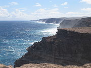
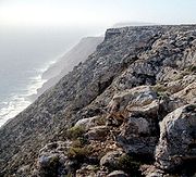
Zuytdorp Cliffs
Encyclopedia
Western Australia
Western Australia is a state of Australia, occupying the entire western third of the Australian continent. It is bounded by the Indian Ocean to the north and west, the Great Australian Bight and Indian Ocean to the south, the Northern Territory to the north-east and South Australia to the south-east...
n Indian Ocean
Indian Ocean
The Indian Ocean is the third largest of the world's oceanic divisions, covering approximately 20% of the water on the Earth's surface. It is bounded on the north by the Indian Subcontinent and Arabian Peninsula ; on the west by eastern Africa; on the east by Indochina, the Sunda Islands, and...
coast in Shark Bay
Shark Bay
Shark Bay is a World Heritage listed bay in Western Australia. The term may also refer to:* the locality of Shark Bay, now known as Denham* Shark Bay Marine Park* Shark Bay , a shark exhibit at Sea World, Gold Coast, Australia* Shire of Shark Bay...
. The cliffs extend from just north of the mouth of the Murchison River at Kalbarri
Kalbarri, Western Australia
Kalbarri is a coastal town in the Mid West region located 592 km north of Perth, Western Australia. The town is found at the mouth of the Murchison River and has an elevation of...
, to Pepper Point south of Steep Point
Steep Point, Western Australia
Steep Point is the westernmost point of the Australian mainland, located at . It is located within the Shark Bay World Heritage site in the Gascoyne region of Western Australia....
. The cliffs are situated in both the Gascoyne and Mid West regions of the state.
At the highest point, near Womerangee Hill, the top of the cliffs are 250 m above the sea. They are named after a trading ship of the Dutch East India Company
Dutch East India Company
The Dutch East India Company was a chartered company established in 1602, when the States-General of the Netherlands granted it a 21-year monopoly to carry out colonial activities in Asia...
, the Zuytdorp
Zuytdorp
The VOC Zuytdorp also Zuiddorp was a trading ship of the Dutch East India Company in the 18th century. On 1 August 1711 it was dispatched from the Netherlands to the trading port of Batavia bearing a load of freshly minted silver coins.Many trading ships of the time had started to use a "fast...
, that was wrecked against the cliffs in 1712.
Geology
The Zuytdorp Cliffs are composed of PleistocenePleistocene
The Pleistocene is the epoch from 2,588,000 to 11,700 years BP that spans the world's recent period of repeated glaciations. The name pleistocene is derived from the Greek and ....
aged limestone
Limestone
Limestone is a sedimentary rock composed largely of the minerals calcite and aragonite, which are different crystal forms of calcium carbonate . Many limestones are composed from skeletal fragments of marine organisms such as coral or foraminifera....
, a formation called the Tamala Limestone
Tamala Limestone
Tamala Limestone is the geological name given to the widely occurring eolianite limestone deposits on the western coastline of Western Australia, between Shark Bay in the north and nearly to Albany in the south...
. This limestone formed by the cementation of ancient calcareous
Calcareous
Calcareous is an adjective meaning mostly or partly composed of calcium carbonate, in other words, containing lime or being chalky. The term is used in a wide variety of scientific disciplines.-In zoology:...
sand dunes that accumulated near the coast during episodes of the last ice age
Ice age
An ice age or, more precisely, glacial age, is a generic geological period of long-term reduction in the temperature of the Earth's surface and atmosphere, resulting in the presence or expansion of continental ice sheets, polar ice sheets and alpine glaciers...
. It has been inferred that the relatively straight edge of the cliffs is due to a major fault line just off shore.
Further reading
- Hocking R.M., van der Graaff W.J.E., Blockley J.G., Butcher B.P. 1982. Ajana, Western Australia, 1:250,000 Geological Map Series, SG50-13, Explanatory Notes, Geological Survey of Western Australia. GSWA download search