
Zingst
Encyclopedia

Fischland-Darß-Zingst
Fischland-Darß-Zingst is a peninsula on the coast of Mecklenburg-Vorpommern in Germany. Its full length is 45 km. The three parts of the peninsula, from west to east, are Fischland, Darß and Zingst....
Peninsula, located in Mecklenburg-Vorpommern, Germany
Germany
Germany , officially the Federal Republic of Germany , is a federal parliamentary republic in Europe. The country consists of 16 states while the capital and largest city is Berlin. Germany covers an area of 357,021 km2 and has a largely temperate seasonal climate...
between the cities Rostock
Rostock
Rostock -Early history:In the 11th century Polabian Slavs founded a settlement at the Warnow river called Roztoc ; the name Rostock is derived from that designation. The Danish king Valdemar I set the town aflame in 1161.Afterwards the place was settled by German traders...
and Stralsund
Stralsund
- Main sights :* The Brick Gothic historic centre is a UNESCO World Heritage Site.* The heart of the old town is the Old Market Square , with the Gothic Town Hall . Behind the town hall stands the imposing Nikolaikirche , built in 1270-1360...
on the southern coast of the Baltic Sea
Baltic Sea
The Baltic Sea is a brackish mediterranean sea located in Northern Europe, from 53°N to 66°N latitude and from 20°E to 26°E longitude. It is bounded by the Scandinavian Peninsula, the mainland of Europe, and the Danish islands. It drains into the Kattegat by way of the Øresund, the Great Belt and...
. The area is part of the Pomerania
Pomerania
Pomerania is a historical region on the south shore of the Baltic Sea. Divided between Germany and Poland, it stretches roughly from the Recknitz River near Stralsund in the West, via the Oder River delta near Szczecin, to the mouth of the Vistula River near Gdańsk in the East...
n coast. Zingst Peninsula extends into an eastward spit
Spit (landform)
A spit or sandspit is a deposition landform found off coasts. At one end, spits connect to land, and extend into the sea. A spit is a type of bar or beach that develops where a re-entrant occurs, such as at cove's headlands, by the process of longshore drift...
of nearly 20 kilometres length and has a width of just 2 to 4 kilometres.
Zingst separates the Baltic Sea from the Bodden Inlet, which belongs to the Darß-Zingster-Boddenkette (Darß-Zingst Bodden Chain), a large or estuary
Estuary
An estuary is a partly enclosed coastal body of water with one or more rivers or streams flowing into it, and with a free connection to the open sea....
http://www.pml.ac.uk/biomare/sites/Darß-Zingst.htm. The shallow waters of the inlet are a major rest stop for the migratory European crane
Crane (bird)
Cranes are a family, Gruidae, of large, long-legged and long-necked birds in the order Gruiformes. There are fifteen species of crane in four genera. Unlike the similar-looking but unrelated herons, cranes fly with necks outstretched, not pulled back...
s. In spring and fall, up to 3,000 birds gather there before their migration to and from Spain http://www.stadt-barth.de/tourismus/e_darss.html http://www.vorpommern.de/1/index_521.htm. Most of the estuary and the eastern end of the peninsula are part of the National Park Vorpommersche Boddenlandschaft (Western Pomerania Lagoon Area National Park
Western Pomerania Lagoon Area National Park
The Western Pomerania Lagoon Area National Park is Mecklenburg-Vorpommern's largest national park situated at the coast of the Baltic Sea...
).
Until the early 1870s, Zingst was an island, separated from Darß
Darß
The Darß is the middle part of the peninsula of Fischland-Darß-Zingst on the southern shore of the Baltic Sea in the German state of Mecklenburg-Western Pomerania. The peninsula's name comes from the names of the three regions making up the peninsula. There is a large forest in the Darß...
by the Prerowstrom, a narrow strait. A storm tide in 1874 closed the strait, which had connected Bodden Inlet and the Baltic Sea. A road now connects Zingst and Darß on a 100 metre wide land bridge.
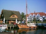
The soils of Zingst consist almost entirely of sand. The sand is white in colour which makes it popular with sunbathers and tourists. Dunes border the Baltic Sea and enclose low ground about half a metre below sea level. The low land results in swampy conditions in the interior of the peninsula, and these swamps offer habitat to a wide variety of wilfdlife http://www.howtogermany.com/pages/beaches.html. There are also ruins of Slavic fortifications, the Hertesburg are on Zingster side.
Settlement
East of the Prerowstrom, surrounded by countryside and the Freesenbruchs, is the town of Barth (population 8,000), which was created by the unification of the settlements of Pahlen, Hanshagen and Rothem ho. Hanshagen and Pahlen date from the 13th Century.The nearby town of Zingst has a population of about 3,200.
Rocket Experiments
During the Cold WarCold War
The Cold War was the continuing state from roughly 1946 to 1991 of political conflict, military tension, proxy wars, and economic competition between the Communist World—primarily the Soviet Union and its satellite states and allies—and the powers of the Western world, primarily the United States...
, when the area was part of East Germany, the eastern part of the peninsula was a restricted military area, used for meteorological rocket experiments. Various experiments were conducted between 1970 and 1992 in an area known as Sundi Meadows. There were 5 launches of the Polish rocket "Meteor 1E" in the early 1970s. On October 21, 1988 launches of Russian of the "MMR06-M" type rockets began. The restricted area measured just 23.6 kilometres by 25.5 kilometers. As the rockets reached heights up to 80 kilometres, the launch angle of the unguided rockets had to be determined with an accuracy of 2 degrees in order to prevent an impact outside of the restricted area.
The first launches of MMR06-M rockets were not successful due to various technical difficulties. The first successful launch with a meteorological payload occurred on April 12, 1989. Additional launches continued for a short time after the fall of the Berlin Wall
Berlin Wall
The Berlin Wall was a barrier constructed by the German Democratic Republic starting on 13 August 1961, that completely cut off West Berlin from surrounding East Germany and from East Berlin...
and German reunification (October 3, 1990). They were finally ended on December 19, 1990 for safety and technological reasons.
Nevertheless, between February 14, 1992 and April 10, 1992 a total of 19 Russian rockets of the MMR06-M type were launched at Zingst, of which 6 were successful. Although further rockets were still available for testing, the launches of MMR06-M rockets in Zingst were stopped in April 1992 because of the removal of German Federal Armed Forces
German Army
The German Army is the land component of the armed forces of the Federal Republic of Germany. Following the disbanding of the Wehrmacht after World War II, it was re-established in 1955 as the Bundesheer, part of the newly formed West German Bundeswehr along with the Navy and the Air Force...
from the place.
List of Launches
|-
| October 21, 1988
| November 1, 1988
| November 4, 1988
| November 8, 1988
| November 22, 1988
| November 23, 1988
| April 7, 1989
| April 14, 1989
| April 26, 1989
| May 10, 1989
| May 24, 1989
| June 21, 1989
| September 6, 1989
| October 10, 1989
| October 18, 1989
| November 1, 1989
| November 8, 1989
| December 8, 1989
| December 20, 1989
| January 10, 1990
| January 19, 1990
| February 14, 1990
| March 21, 1990
| March 28, 1990
| May 9, 1990
| May 11, 1990
| May 30, 1990
| June 8, 1990
| June 13, 1990
| June 20, 1990
| September 12, 1990
| September 26, 1990
| October 5, 1990
| October 12, 1990
| October 17, 1990
| October 17, 1990
| November 2, 1990
| November 2, 1990
| November 23, 1990
| December 5, 1990
| December 14, 1990
| December 19, 1990
| December 19, 1990
| February 14, 1992
| February 19, 1992
| February 21, 1992
| February 26, 1992
| February 26, 1992
| February 28, 1992
| March 6, 1992
| March 6, 1992
| March 11, 1992
| March 11, 1992
| March 20, 1992
| March 20, 1992
| March 25, 1992
| March 25, 1992
| March 27, 1992
| April 1, 1992
| April 3, 1992
| April 3, 1992
| April 10, 1992
Remarks: S = Success; PS = Partial Success; F = Failure; EF = Experiment Failure
Sources
- http://www.astronautix.com/lvs/mmr06.htm
- http://www.astronautix.com/sites/zingst.htm
- http://www.nilu.no/projects/ccc/sitedescriptions/de/de09.html
- Satellite picture of former launch site