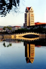
|
|
|
|
Yantai
|
| |
|
| |
})
|-
| Area
| 13,739.9 km²
|-
| Coastline
| 702.5 km
|-
| Population
| 6,468,200 (2003)
|-
| GDP - Total - Per Capita
| ¥287.9 billion (2007) ¥44,242 (2007)
|-
| Major Nationalities
| Han: 99.80% Korean: 0.049% Manchu: 0.048% Va: 0.020% Mongol: 0.016%
|-
| County-level divisions
| 12
|-
| Township-level divisions
| 148
|-
| CPC Committee Secretary
| Sun Yongchun ???
|-
| Mayor
| Zhang Jiangting ???
|-
| Area code
| 535
|-
| Postal Code
| 264000-265800
|-
| License Plate Prefix
| ?F
|-
| align="center" colspan=2 | |-
|}
Yantai is a prefecture-level city in northeastern Shandong province, People's Republic of China.

Discussion
Ask a question about 'Yantai'
Start a new discussion about 'Yantai'
Answer questions from other users
|
Encyclopedia
})
|-
| Area
| 13,739.9 km²
|-
| Coastline
| 702.5 km
|-
| Population
| 6,468,200 (2003)
|-
| GDP - Total - Per Capita
| ¥287.9 billion (2007) ¥44,242 (2007)
|-
| Major Nationalities
| Han: 99.80% Korean: 0.049% Manchu: 0.048% Va: 0.020% Mongol: 0.016%
|-
| County-level divisions
| 12
|-
| Township-level divisions
| 148
|-
| CPC Committee Secretary
| Sun Yongchun ???
|-
| Mayor
| Zhang Jiangting ???
|-
| Area code
| 535
|-
| Postal Code
| 264000-265800
|-
| License Plate Prefix
| ?F
|-
| align="center" colspan=2 | |-
|}
Yantai is a prefecture-level city in northeastern Shandong province, People's Republic of China. Located on the southern coast of the Bohai Sea and the eastern coast of the Laizhou Bay, Yantai borders the cities of Qingdao and Weihai to the southwest and east respectively.
The largest fishing seaport in Shandong and a robust economic center today, Yantai used to be known to the West as Chefoo, a misnomer which refers, in Chinese, solely to Zhifu Island, which is historically governed by Yantai.
The contemporary name of Yantai came from the watchtowers constructed on Mount Qi in 1398, during the reign of the Hongwu Emperor, founding emperor of the Ming Dynasty (yan—smoke; tai—tower). The towers served to raise alarms against invasions of Japanese pirates.
Administration The prefecture-level city of Yantai administers 12 county-level divisions, including 4 districts, 7 county-level cities, 1 county and one development zone.
These are further divided into 148 township-level divisions, including 94 towns, 6 townships and 48 subdistricts.
History The region was inhabited by the non-Han people of the Eastern Yi, who were believed to have established a small state during the Xia Dynasty on the site of present-day Laizhou City. It became a feudal state called Lai until the Warring States Period, when it was annexed by the State of Qi. During the Qin Dynasty, Yantai belonged to the Qi Prefecture, later renamed Donglai Prefecture during the Han Dynasty. The area was known as the Donglai Kingdom during the Jin Dynasty (265-420) but later returned to prefecture status (first jùn, then zhou). In the Tang Dynasty and following it was known as the Teng-chou prefecture, part of Henan Circuit. Next, the city became the Laizhou Subprefecture and, eventually, the Dengzhou Subprefecture in the time of the Qing Dynasty.
In July 1858 the Chinese empire signed the Treaty of Tianjin and Dengzhou was renamed for the last time. Yantai opened its harbor for business in May 1861, but was not officially designated an international trading port until later that year on August 22. This decree was accompanied by the construction of the Donghai Pass. 17 nations, including Britain, established embassies in Yantai. The Chefoo Convention was signed there in 1876.
Yantai literally means "smoky tower". In the Ming Dynasty, locals used wolf dung to light fires (Langyan) to warn the whole village of approaching Japanese Pirates (Wokou). The city was nothing but a small fishing village until the late 19th century when it became a treaty port for the British, handed over by the falling Qing Dynasty, which had been defeated in the Opium War. Then with the Germans' power over the whole Shandong peninsula in early 20th century, Yantai was also controlled by Germans for about 20 years. After the Americans won World War I, they turned Yantai into a summer station for their entire Asian fleet. Then the Japanese set up a trading establishment in the town. You may be able to get an idea of the different influences at the western style Yantai Museum, which used to be a guild hall. However, the colourful history has not left a distinctive architectural mark, there has never been a foreign concession, and though you will see an occasional nineteenth-century grand European building, most of the town is of much more recent origin. After liberation, the town's name was changed from the original, Chefoo, to Yantai and was opened to the world as an ice-free trade port in 1984.
On November 12, 1911, the eastern division of Tongmeng Hui declared itself a part of the revolutionary movement. The next day, it established the Shandong Military Government and, the day after that, renamed itself the Yantai Division of the Shandong Military Government (????????). In 1914, Jiaodong Circuit was established with Yantai as the capital. Jiaodong Circuit was renamed Donghai Circuit in 1925. On January 19, 1938, Yantai participated as part of an anti-Japanese revolutionary committee.
After the creation of the People's Republic of China, in 1950, Yantai was officially awarded city status with the outer lying towns of Laiyang and Wendeng tacked on as "Special Regions". Wendeng was merged into Laiyang six years later, and this larger Laiyang Special Region was combined with Yantai City to become simply Yantai Region. Yantai is of strategic importance to Chinese defence as it and the city of Dalian are primary coastal guard points for Beijing. In November 1983, the region became a prefecture-level city. Since then, Yantai has worked its way into becoming a modernized economic center in Shandong Province.
Geography
Yantai Region is located north-central on the Shandong Peninsula, south of the Bohai Sea, and parallel to the southern tip of Korea. It has a coast line of 909 km. The topographical breakdown consists of:
- 36.62% mountain
- 39.7% hill
- 20.78% plains
- 2.90% basins
Average mountain height is 500 meters, with the highest point at 922.8 meters on Mount Kunyu. Hills range from 100 to 300 meters.
There are 121 rivers over 5 kilometer in length, the largest being:
- Wulong River
- Dagu River
- Dagujia River
- Wang River
- Jie River
- Huangshui River
- Xin'an River
2643.60 km² is urbanized.
Only Qixia County is located entirely inland, all other county-level entities are coastal, with Changdao consisting entirely of islands.
The annual mean temperature in Yantai is 12 oC. The annual rainfall is 20 mm.
Economy Yantai is currently the second largest industrial city in Shandong, next only to Qingdao. However, the region's largest industry is agriculture. It is famous throughout China for a particular variety of apple and is home to the country's largest and oldest grape winery (Changyu).
Two sub-county special economic zones also exist, the Yantai Economy and Technology Development Area (YEDA), created in 1984 in northern Fushan District, and the Yantai Export Processing Area, formed in 2000 in north Zhifu District.
The county-level city of Longkou is well known throughout China for its production of cellophane noodles.
Education
The following are a list of prominent Yantai higher education institutions.
Transport
The Yantai Laishan International Airport provides scheduled flights to major airports in China as well as Seoul, Osaka and Hong Kong.
Tourism
Because of its fair weather and extensive coasts Yantai is a popular summer retreat. It is also home to Asia's first bowling alley, which is no longer in operation. But there is the haunted house on the fourth floor of Parksons, a highly exhilarating tourist attraction.
Penglai City's Dan Cliffs is said to be the departure point of the Eight Immortals on their trip to the Conference of the Magical Peach.
Sister cities Yantai is a sister city of the following cities around the world.
Angers, France
Angus, United Kingdom
Beppu, Japan
Gunsan, South Korea
Miyako, Japan
Örebro, Sweden
Phuket, Thailand
San Diego, U.S.
Tauranga, New Zealand
Ulsan, South Korea
Vladivostok, Russia
Wonju, South Korea
See also
Notable people
External links
- (available in Chinese, English, German, French, Japanese and Korean)
|
| |
|
|