

Yaiza, Las Palmas
Encyclopedia
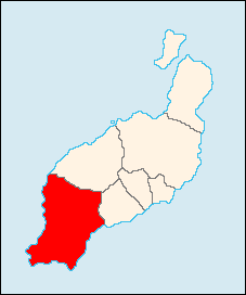
Yaiza, Lanzarote
Lanzarote
Lanzarote , a Spanish island, is the easternmost of the autonomous Canary Islands, in the Atlantic Ocean, approximately 125 km off the coast of Africa and 1,000 km from the Iberian Peninsula. Covering 845.9 km2, it stands as the fourth largest of the islands...
is the gateway to the south of the island of Lanzarote and onward to Playa Blanca
Playa Blanca
Playa Blanca, meaning "White Beach" is the southernmost town of the Spanish island of Lanzarote. It is the newest, yet fastest growing resort on the Island...
. It is a pleasant sleepy village where most of the local council business is done.
With recently tree lined roads, it houses the local townhall and has a floodlit public football stadium. Yaiza is mainly famous for Charco Verde which features a green pond and colorful rims that look like chocolate. The pavement-like ground is near the rim and is fenced. Part of the land to the north is part of the Timanfaya National Park.
The population is 9,664 (ISTAC, 2006), its density is 36.78/km² and the area is 211.84 km². It is located a main highway linking Taiza and Teguise as well as east to Arrecife. It is the westernmost and the southernmost terminus of LZ3
LZ3 (Lanzarote)
LZ3 is one of the main highways of Lanzarote in the Canary Islands. It connects the centre of the island to the south-west and is the southern most of highways on the island....
. The main industry are agriculture and tourism especially in the park area. The Atlantic Ocean
Atlantic Ocean
The Atlantic Ocean is the second-largest of the world's oceanic divisions. With a total area of about , it covers approximately 20% of the Earth's surface and about 26% of its water surface area...
is to the west and north, the mountains are to the south, central and the eastern part. Farmlands along with barren lands dominate the rest of the municipality.
Geography

- Location:
- Latitude: 28.95 (28°57') N
- Longitude: 13.75 (13°45') W
- Altitude:
- Lowest: Atlantic Ocean
- Centre: 192 m
- Postal code: 35570
Sites of interest
- El Golfo
- Playa BlancaPlaya BlancaPlaya Blanca, meaning "White Beach" is the southernmost town of the Spanish island of Lanzarote. It is the newest, yet fastest growing resort on the Island...
(meaning white beach), a beach located in the extreme south of Yaiza. - Hacha GrandeHacha GrandeHacha Grande is a mountain on the Canary Island of Lanzarote, with an elevation of 562 m above sea level. Its name is Spanish meaning Large Axe....
, a mountain - Puerto Calero marina
Other
Yaiza has schools, lyceums, a few gymnasia, a few churches, beaches, a post office, parks and a square (plaza).See also
- List of municipalities in Las Palmas
- Canarian Whale and Dolphin Museum in Puerto Calero.
| North: Tinajo Tinajo, Las Palmas Tinajo is a Canarian municipality in the western portion of the island of Lanzarote in the Las Palmas province in the Canary Islands. The population is 5,066 , its density is 37.45/km² and the area is 135.28 km². It is located on a main highway linking Taiza and Teguise as well as east to... |
Northeast: Tías Tías, Las Palmas Tías is a town and borough in the southwest of the island of Lanzarote, province of Las Palmas, autonomous community of the Canary Islands, Spain.It is located southeast of the main highway linking Arrecife and Yaiza.... |
|
| West: Atlantic Ocean |
Yaiza | East: Tías Tías, Las Palmas Tías is a town and borough in the southwest of the island of Lanzarote, province of Las Palmas, autonomous community of the Canary Islands, Spain.It is located southeast of the main highway linking Arrecife and Yaiza.... and the Atlantic Ocean |
| South: Atlantic Ocean |