Wuwei is located in northwest central Gansu province. In the north it borders
Inner MongoliaInner Mongolia is an autonomous region of the People's Republic of China, located in the northern region of the country. Inner Mongolia shares an international border with the countries of Mongolia and the Russian Federation...
, in the southwest,
QinghaiQinghai ; Oirat Mongolian: ; ; Salar:) is a province of the People's Republic of China, named after Qinghai Lake...
. Its central location between three western capitals,
LanzhouLanzhou is the capital and largest city of Gansu Province in Northwest China. A prefecture-level city, it is a key regional transportation hub, allowing areas further west to maintain railroad connections to the eastern half of the country....
,
XiningXining is the capital of Qinghai province, People's Republic of China, and the largest city on the Tibetan Plateau. It has 2,208,708 inhabitants at the 2010 census whom 1,198,304 live in the built up area made of 4 urban districts.-History:...
, and
Yinchuan makes it an important business and transportation hub for the area. Because of its position along the
Hexi CorridorHexi Corridor or Gansu Corridor refers to the historical route in Gansu province of China. As part of the Northern Silk Road running northwest from the bank of the Yellow River, it was the most important route from North China to the Tarim Basin and Central Asia for traders and the military. The...
, historically the only route from central China to western China and the rest of
Central AsiaCentral Asia is a core region of the Asian continent from the Caspian Sea in the west, China in the east, Afghanistan in the south, and Russia in the north...
, many major railroads and national highways pass through Wuwei.
Geography, geology and climate
Wuwei's geography is dominated by three plateaus, the
LoessThe Loess Plateau , also known as the Huangtu Plateau, is a plateau that covers an area of some 640,000 km² in the upper and middle reaches of China's Yellow River. Loess is the name for the silty sediment that has been deposited by wind storms on the plateau over the ages...
,
TibetanThe Tibetan Plateau , also known as the Qinghai–Tibetan Plateau is a vast, elevated plateau in Central Asia covering most of the Tibet Autonomous Region and Qinghai, in addition to smaller portions of western Sichuan, southwestern Gansu, and northern Yunnan in Western China and Ladakh in...
, and
MongolianThe Mongolian Plateau is part of the larger Central Asian Plateau and has an area of approximately 2,600,000 square kilometres. It is occupied by Mongolia in the north and Inner Mongolia in the south. The plateau includes the Gobi Desert as well as dry steppe regions...
. Elevation can be generalized as, the south is high and the north is low, with elevations ranging from 1020 to 4874 m (3,346.5 to 15,990.8 ) above sea-level. Its area is 33000 km² (12,741.4 sq mi). Average annual temperature is 7.8 °C (46 °F). The climate is arid or semi-arid with rainfall between 60 millimetre. Evaporation is from 1400 millimetre, creating a
net loss of water each yearWater crisis is a general term used to describe a situation where the available water within a region is less than the region's demand. The term has been used to describe the availability of potable water in a variety of regions by the United Nations and other world organizations...
. There are 2200–3000 sunlight hours each year and from 85–165 frost free days. Temperatures during summer in excess of 45 °C (113 °F) in the shade are by no means unheard of.
Southwest of Wuwei, there is a 230 metres (754.6 ft) thick
TianzhuTenzhu Tibetan Autonomous County is in the prefecture-level city of Wuwei in the Chinese province of Gansu. It has an area of 7,147km² and approximately 230,000 inhabitants...
Formation made of clastics intercalated with sandy
shaleShale is a fine-grained, clastic sedimentary rock composed of mud that is a mix of flakes of clay minerals and tiny fragments of other minerals, especially quartz and calcite. The ratio of clay to other minerals is variable. Shale is characterized by breaks along thin laminae or parallel layering...
and shale. Minerals deposits occurring in the vicinity of Wuwei include
graphiteThe mineral graphite is one of the allotropes of carbon. It was named by Abraham Gottlob Werner in 1789 from the Ancient Greek γράφω , "to draw/write", for its use in pencils, where it is commonly called lead . Unlike diamond , graphite is an electrical conductor, a semimetal...
,
ironIron is a chemical element with the symbol Fe and atomic number 26. It is a metal in the first transition series. It is the most common element forming the planet Earth as a whole, forming much of Earth's outer and inner core. It is the fourth most common element in the Earth's crust...
,
titaniumTitanium is a chemical element with the symbol Ti and atomic number 22. It has a low density and is a strong, lustrous, corrosion-resistant transition metal with a silver color....
, and
limestoneLimestone is a sedimentary rock composed largely of the minerals calcite and aragonite, which are different crystal forms of calcium carbonate . Many limestones are composed from skeletal fragments of marine organisms such as coral or foraminifera....
.
History
In ancient times, Wuwei was called Liangzhou (凉州 - the name retained by today's Wuwei's
central urban districtThe Liangzhou District is an administrative district in Gansu, the People's Republic of China. It is one of 17 districts of Gansu. It is part of the Wuwei prefecture, with the city of the same name being the prefectural seat.-Geography:...
) and is the eastern terminus of the
Hexi CorridorHexi Corridor or Gansu Corridor refers to the historical route in Gansu province of China. As part of the Northern Silk Road running northwest from the bank of the Yellow River, it was the most important route from North China to the Tarim Basin and Central Asia for traders and the military. The...
. People began settling here 5,000 years ago. It was a key link for the
Northern Silk RoadThe Northern Silk Road is a prehistoric trackway in northern China originating in the early capital of Xi'an and extending north of the Taklamakan Desert to reach the ancient kingdoms of Parthia, Bactria and eventually Persia and Rome. It is the northern-most branch of several Silk Roads providing...
, and a number of important archaeological finds were uncovered from Wuwei, including ancient copper carts with stone animals. It became an important provincial capital during the Former Han Dynasty as the
Hou Hanshu makes clear:
"In the third year [170 CE], Meng Tuo, the Inspector of Liangzhou, sent the Provincial Officer Ren She, commanding five hundred soldiers from DunhuangDunhuang is a city in northwestern Gansu province, Western China. It was a major stop on the ancient Silk Road. It was also known at times as Shāzhōu , or 'City of Sands', a name still used today...
, who, with the Wuji Major Cao Kuan, and Chief Clerk of the Western Regions, Zhang Yan, brought troops from Yanqi (Karashahr), Qiuci (KuchaKuchaor Kuche Uyghur , Chinese Simplified: 库车; Traditional: 庫車; pinyin Kùchē; also romanized as Qiuzi, Qiuci, Chiu-tzu, Kiu-che, Kuei-tzu from the traditional Chinese forms 屈支 屈茨; 龜玆; 龟兹, 丘玆, also Po ; Sanskrit: Kueina, Standard Tibetan: Kutsahiyui was an ancient Buddhist kingdom...
), and the Nearer and Further Kingdoms of Jushi (Turfan and Jimasa), altogether numbering more than 30,000, to punish Shule (KashgarKashgar or Kashi is an oasis city with approximately 350,000 residents in the western part of the Xinjiang Uyghur Autonomous Region of the People's Republic of China. Kashgar is the administrative centre of Kashgar Prefecture which has an area of 162,000 km² and a population of approximately...
). They attacked the town of Zhenzhong (Arach) but, having stayed for more than forty days without being able to take it, they withdrew. Following this, the kings of Shule (KashgarKashgar or Kashi is an oasis city with approximately 350,000 residents in the western part of the Xinjiang Uyghur Autonomous Region of the People's Republic of China. Kashgar is the administrative centre of Kashgar Prefecture which has an area of 162,000 km² and a population of approximately...
) killed one another repeatedly while the Imperial Government was unable to prevent it."
In
121 BCYear 121 BC was a year of the pre-Julian Roman calendar. At the time it was known as the Year of the Consulship of Opimius and Allobrogicus...
HanThe Han Dynasty was the second imperial dynasty of China, preceded by the Qin Dynasty and succeeded by the Three Kingdoms . It was founded by the rebel leader Liu Bang, known posthumously as Emperor Gaozu of Han. It was briefly interrupted by the Xin Dynasty of the former regent Wang Mang...
emperor
WudiEmperor Wu of Han , , personal name Liu Che , was the seventh emperor of the Han Dynasty of China, ruling from 141 BC to 87 BC. Emperor Wu is best remembered for the vast territorial expansion that occurred under his reign, as well as the strong and centralized Confucian state he organized...
brought his cavalry here to defend the
Hexi CorridorHexi Corridor or Gansu Corridor refers to the historical route in Gansu province of China. As part of the Northern Silk Road running northwest from the bank of the Yellow River, it was the most important route from North China to the Tarim Basin and Central Asia for traders and the military. The...
against the
XiongnuThe Xiongnu were ancient nomadic-based people that formed a state or confederation north of the agriculture-based empire of the Han Dynasty. Most of the information on the Xiongnu comes from Chinese sources...
Huns. His military success allowed him to expand the corridor westward. Its importance as a stop along the
Silk RoadThe Silk Road or Silk Route refers to a historical network of interlinking trade routes across the Afro-Eurasian landmass that connected East, South, and Western Asia with the Mediterranean and European world, as well as parts of North and East Africa...
made it a crossroads of cultures and ethnic groups from all over central Asia. Numerous
BuddhistBuddhism is a religion and philosophy encompassing a variety of traditions, beliefs and practices, largely based on teachings attributed to Siddhartha Gautama, commonly known as the Buddha . The Buddha lived and taught in the northeastern Indian subcontinent some time between the 6th and 4th...
grottoA grotto is any type of natural or artificial cave that is associated with modern, historic or prehistoric use by humans. When it is not an artificial garden feature, a grotto is often a small cave near water and often flooded or liable to flood at high tide...
es and
templeA temple is a structure reserved for religious or spiritual activities, such as prayer and sacrifice, or analogous rites. A templum constituted a sacred precinct as defined by a priest, or augur. It has the same root as the word "template," a plan in preparation of the building that was marked out...
s in the area attest to its role as a path for bringing Buddhism from
IndiaIndia , officially the Republic of India , is a country in South Asia. It is the seventh-largest country by geographical area, the second-most populous country with over 1.2 billion people, and the most populous democracy in the world...
and
AfghanistanAfghanistan , officially the Islamic Republic of Afghanistan, is a landlocked country located in the centre of Asia, forming South Asia, Central Asia and the Middle East. With a population of about 29 million, it has an area of , making it the 42nd most populous and 41st largest nation in the world...
to China.
During the
Three KingdomsThe Three Kingdoms period was a period in Chinese history, part of an era of disunity called the "Six Dynasties" following immediately the loss of de facto power of the Han Dynasty rulers. In a strict academic sense it refers to the period between the foundation of the state of Wei in 220 and the...
period (184-280), Liangzhou was governed by
QiangThe Qiang people are an ethnic group of China. They form one of the 56 ethnic groups officially recognized by the People's Republic of China, with a population of approximately 200,000, living mainly in northwestern part of Sichuan province....
leader
Ma TengMa Teng was a warlord during the late Han Dynasty period of Chinese history. He controlled Liang Province together with his sworn brother Han Sui...
. After the death of Ma Teng,
Ma ChaoMa Chao was the oldest son of Ma Teng and a military general during the late Han Dynasty and early Three Kingdoms era of Chinese history. In Luo Guanzhong's historical novel Romance of the Three Kingdoms, he received the nickname "Ma Chao the Splendid" due to his elaborate armour and grand skill...
assumed the post and governed the province for a short time before it fell into the hands of
Cao CaoCao Cao was a warlord and the penultimate chancellor of the Eastern Han Dynasty who rose to great power during the dynasty's final years. As one of the central figures of the Three Kingdoms period, he laid the foundations for what was to become the state of Cao Wei and was posthumously titled...
, ruler of Wei Kingdom.
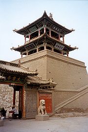
Famous cultural relics from Wuwei include the Galloping Bronze Horse (铜奔马), Western Xia stele (西夏碑), White Tower Temple (白塔寺), Tianti Mountain Grotto (天梯山石窟), Luoshi Temple Tower (罗什寺塔), and the Wen Shrine (文庙).
Administration
1 urban district, 2 counties, 1 autonomous county, 116 towns, and 41 townships
| Map |
# |
Name |
Hanzi |
Hanyu Pinyin |
Population
(2003 est.) |
Area (km²) |
Density (/km²) |
| |
| 1 |
Liangzhou District The Liangzhou District is an administrative district in Gansu, the People's Republic of China. It is one of 17 districts of Gansu. It is part of the Wuwei prefecture, with the city of the same name being the prefectural seat.-Geography:...
|
凉州区 |
Liángzhōu Qū |
980,000 |
5,081 |
193 |
| 2 |
Minqin County Minqin County is an administrative district in Gansu, the People's Republic of China. It is one of 58 counties of Gansu. It is part of the Wuwei prefecture, with the city of the same name being the prefecture seat. Its postal code is 733300, and its population in 1999 was 281,826 people.In older...
|
民勤县 |
Mínqín Xiàn |
290,000 |
16,016 |
18 |
| 3 |
Gulang County Gulang County is an administrative district in Gansu, the People's Republic of China. It is one of 58 counties of Gansu. It is part of the Wuwei prefecture, with the city of the same name being the prefecture seat. Its postal code is 733100, and its population in 2006 was 393,200 people...
|
古浪县 |
Gǔlàng Xiàn |
390,000 |
5,287 |
74 |
| 4 |
Tianzhu Tibetan Autonomous County Tenzhu Tibetan Autonomous County is in the prefecture-level city of Wuwei in the Chinese province of Gansu. It has an area of 7,147km² and approximately 230,000 inhabitants...
|
天祝藏族自治县 |
Tiānzhù Zàngzú Zìzhìxiàn |
210,000 |
6,865 |
31 |
Demographics
Population 1,930,200, urban 509,600 with 38 ethnic groups represented including
HanHan Chinese are an ethnic group native to China and are the largest single ethnic group in the world.Han Chinese constitute about 92% of the population of the People's Republic of China , 98% of the population of the Republic of China , 78% of the population of Singapore, and about 20% of the...
,
HuiThe Hui people are an ethnic group in China, defined as Chinese speaking people descended from foreign Muslims. They are typically distinguished by their practice of Islam, however some also practice other religions, and many are direct descendants of Silk Road travelers.In modern People's...
, Mongol,
TuThe Monguor or Tu people , White Mongol/Chagan Mongol are one of the 56 officially recognized ethnic groups in the People's Republic of China. The "Tu" ethnic category was created in the 1950s....
,
TibetanThe Tibetan people are an ethnic group that is native to Tibet, which is mostly in the People's Republic of China. They number 5.4 million and are the 10th largest ethnic group in the country. Significant Tibetan minorities also live in India, Nepal, and Bhutan...
, etc.
Economy
Consistent sunlight and fertile soil make agriculture one of Wuwei’s biggest industries. Other important industries are textiles, metallurgy, and construction materials. Melons, vegetables, wine and livestock are all major agricultural products.
Organic farmingOrganic farming is the form of agriculture that relies on techniques such as crop rotation, green manure, compost and biological pest control to maintain soil productivity and control pests on a farm...
is a trend with more land being set aside for “green farming” each year. Land use can be broken down into the following:
of water of forest of grassland. of “undeveloped” land. of farmland.
-
- 8000 square kilometres (3,088.8 sq mi) of corn
- 4000 square kilometres (1,544.4 sq mi) of vegetables
- 3000 square kilometres (1,158.3 sq mi) of melons
- 5000 square kilometres (1,930.5 sq mi) for livestock
- 800 square kilometres (308.9 sq mi) of vineyards
Transport
Wuwei is served by
China National Highway 312China National Highway 312 , also referred to as Route 312 or The Mother Road, is an important highway that runs east-west across the breadth of People's Republic of China. It begins at the port city Shanghai and ends at Khorgas in the Ili River valley, on the border with Kazakhstan. In total it...
and the Lanzhou-Xinjiang Railway.
External links
The source of this article is
wikipedia, the free encyclopedia. The text of this article is licensed under the
GFDL.