

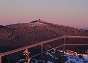
Wurmberg (Harz)
Encyclopedia
Mountain
Image:Himalaya_annotated.jpg|thumb|right|The Himalayan mountain range with Mount Everestrect 58 14 160 49 Chomo Lonzorect 200 28 335 52 Makalurect 378 24 566 45 Mount Everestrect 188 581 920 656 Tibetan Plateaurect 250 406 340 427 Rong River...
in the Harz
Harz
The Harz is the highest mountain range in northern Germany and its rugged terrain extends across parts of Lower Saxony, Saxony-Anhalt and Thuringia. The name Harz derives from the Middle High German word Hardt or Hart , latinized as Hercynia. The legendary Brocken is the highest summit in the Harz...
and the highest in Lower Saxony
Lower Saxony
Lower Saxony is a German state situated in north-western Germany and is second in area and fourth in population among the sixteen states of Germany...
(Germany
Germany
Germany , officially the Federal Republic of Germany , is a federal parliamentary republic in Europe. The country consists of 16 states while the capital and largest city is Berlin. Germany covers an area of 357,021 km2 and has a largely temperate seasonal climate...
).
Geography
The Wurmberg lies north of BraunlageBraunlage
Braunlage is a town and health resort in the Goslar district in Lower Saxony in Germany. It lies within the Harz mountain range, south of the Brocken.Nowadays Braunlage's main business is tourism, particularly ski tourists...
, in the district of Goslar, and west of Schierke
Schierke
Schierke is a village and a former municipality in the Harz district, in the German state of Saxony-Anhalt. Since 1 July 2009, it is part of the town Wernigerode.Schierke was first mentioned as Schiriken in a 1590 deed...
. Its summit
Summit (topography)
In topography, a summit is a point on a surface that is higher in elevation than all points immediately adjacent to it. Mathematically, a summit is a local maximum in elevation...
is located due south of the Brocken and roughly 400 m (as the crow flies
As the crow flies
"As the crow flies" or beelining is an idiom for the shortest route between two points; the geodesic distance.An example is the great-circle distance between Key West and Pensacola, at either end of the U.S...
) south of the state border with Saxony-Anhalt
Saxony-Anhalt
Saxony-Anhalt is a landlocked state of Germany. Its capital is Magdeburg and it is surrounded by the German states of Lower Saxony, Brandenburg, Saxony, and Thuringia.Saxony-Anhalt covers an area of...
. The two mountains are separated by the valley
Valley
In geology, a valley or dale is a depression with predominant extent in one direction. A very deep river valley may be called a canyon or gorge.The terms U-shaped and V-shaped are descriptive terms of geography to characterize the form of valleys...
of the Kalte Bode
Kalte Bode
The Kalte Bode is the left-hand headstream of the River Bode in the High Harz Mountains in the German state of Saxony-Anhalt. It is long.-Name:...
, which in this area is about .
On the Wurmberg there are two prominent crags (Klippen):
- The Kleine Wurmbergklippe ("Small Wurmberg Crag") is between the valley station and the middle station of the Wurmberg Gondola Lift roughly 100 m east of the lift in the pine forest.
- The Große Wurmbergklippe ("Great Wurmberg Crag") is west of the gondola lift between the middle station and the summit station. It lies only a little way above the filled-in upper quarry on the Wurmberg.
On the topmost summit level of the crag there is a triangular offering cup (Opferschale or Zwergenmolle). Many legends, mostly about the "Wild Hunter" (Wilden Jäger) surround this artificially chiselled out rectangular hollow. The Wild Hunter usually epitomises the god Wodin (or Thor
Thor
In Norse mythology, Thor is a hammer-wielding god associated with thunder, lightning, storms, oak trees, strength, the protection of mankind, and also hallowing, healing, and fertility...
) in Germanic mythology
Germanic mythology
Germanic mythology is a comprehensive term for myths associated with historical Germanic paganism, including Norse mythology, Anglo-Saxon mythology, Continental Germanic mythology, and other versions of the mythologies of the Germanic peoples...
.
History
The named Wormberch had already surfaced by the 13th century in the documents and commodity schedules of the County of Regenstein-Blankenburg in connexion with the mining of iron ore. In the 19th century the mountain was still being called Wormsberg or Wormberg, but a convincing derivation of the name has yet to be found.Around 1850 the first trig post was erected on the summit of the Wurmberg to assist in surveying the Harz mountains. It was replaced in 1890 by a wooden tower, also used for trigonometric measurements, that stood until 1930. In 1922 the wooden ski jump was built with its 28 metre high starting tower, which also acted as an observation tower (see below). Since the 1950s there has been a restaurant next to this tower. The Inner German Border that separated the West
West Germany
West Germany is the common English, but not official, name for the Federal Republic of Germany or FRG in the period between its creation in May 1949 to German reunification on 3 October 1990....
and East Germany during the Cold War
Cold War
The Cold War was the continuing state from roughly 1946 to 1991 of political conflict, military tension, proxy wars, and economic competition between the Communist World—primarily the Soviet Union and its satellite states and allies—and the powers of the Western world, primarily the United States...
, ran only a few hundred metres north and east of the summit.
During the Cold War there was a listening post on the summit plateau. In 1972 the US Secret Services built a 81 m high tower, the North Tower on the Wurmberg to monitor and record signals information. This station was demolished on 22 August 1994 and the debris removed. (see also: listening post on the neighbouring Stöberhai
Stöberhai
The Stöberhai is a mountain the Harz highlands in Central Germany, immediately south of the Oder Dam and northwest of Wieda. At a height of it is the highest mountain in the South Harz...
).
Since 1963/65 the Wurmberg gondola lift has run from Braunlage up the mountain. The construction of this lift was carried out in two sections; in 1997 the lift was then completely renovated.
In a container on the summit is one of the 25 monitoring sites in the Lower Saxony air quality
Air Quality Index
Air quality is defined as a measure of the condition of air relative to the requirements of one or more biotic species or to any human need or purpose. Air quality indices are numbers used by government agencies to characterize the quality of the air at a given location...
monitoring network (:de:Lufthygienisches Überwachungssystem Niedersachsen).
Since September 2007 a 70 cm amateur radio
Amateur radio
Amateur radio is the use of designated radio frequency spectrum for purposes of private recreation, non-commercial exchange of messages, wireless experimentation, self-training, and emergency communication...
relay station has also been located on Lower Saxony highest mountain.
The relay has the callsign DB0WUR and transmits on 438.550 MHz. This enables large parts of Lower Saxony, Thuringia
Thuringia
The Free State of Thuringia is a state of Germany, located in the central part of the country.It has an area of and 2.29 million inhabitants, making it the sixth smallest by area and the fifth smallest by population of Germany's sixteen states....
, Hesse
Hesse
Hesse or Hessia is both a cultural region of Germany and the name of an individual German state.* The cultural region of Hesse includes both the State of Hesse and the area known as Rhenish Hesse in the neighbouring Rhineland-Palatinate state...
and Saxony-Anhalt
Saxony-Anhalt
Saxony-Anhalt is a landlocked state of Germany. Its capital is Magdeburg and it is surrounded by the German states of Lower Saxony, Brandenburg, Saxony, and Thuringia.Saxony-Anhalt covers an area of...
to be reached.
Historic stone structures
The peak of the Wurmberg is covered with a variety of odd stone structures that, for a long time, were interpreted as the remnants of an ancient, pre-Christian place of worshipPlace of worship
A place of worship or house of worship is an establishment or her location where a group of people comes to perform acts of religious study, honor, or devotion. The form and function of religious architecture has evolved over thousands of years for both changing beliefs and architectural style...
, several millennia old.
A long, straight staircase of unhewn stone begins at a height of about 90 metres above the iron ore mining district on the eastern flank of the mountain and leads to the edge of the summit plateau in a terraced area with edging of similarly unhewn stones. Colloquially this flight of steps is known as the "Heath Staircase" (Heidetreppe), although in earlier times the name "Witch's Staircase" (Hexentreppe) had been common.
In 1856 Heinrich Pröhle
Heinrich Pröhle
Prof. Dr. Christoph Ferdinand Heinrich Pröhle was a German literary historian, teacher , writer, and folk tale—fairy tale collector .-Disambiguation of Heinrich:The given name »Heinrich« occures in several cases among the...
reported in his Harz Legends that, continuing in a straight line from the steps, there was a stone path on the plateau leading to a round pile of stones. When he collected his tales of the Upper Harz
Upper Harz
The Upper Harz refers to the western and higher part of the Harz mountain range in central Germany. Much of the Upper Harz is over , but at its eastern edge in the High Harz it climbs to over on the Brocken massif.- Geography :...
in 1851 from the inhabitants of Braunlage, they reported that a pagan temple
Temple
A temple is a structure reserved for religious or spiritual activities, such as prayer and sacrifice, or analogous rites. A templum constituted a sacred precinct as defined by a priest, or augur. It has the same root as the word "template," a plan in preparation of the building that was marked out...
had stood on the site.
Between 1949 and 1956 Walter Nowothnig (1907–1971) carried out several archaeological digs on the Wurmberg. Pröhle's collection of legends reinforced his suspicion that the rumour of these steps being laid by a man called Daubert, a horseman-forester who had lived in Braunlage around 1825, was no longer tenable. Nowothnig's excavations, rediscovered the stone path and also uncovered, at the end of the path, a circular rampart
Defensive wall
A defensive wall is a fortification used to protect a city or settlement from potential aggressors. In ancient to modern times, they were used to enclose settlements...
of roughly 10 m diameter which surrounded the ruins of a square stone building. Moreover, south of the path, the foundation of a small circular building was found. In 2006, another, larger rampart was found on the western edge of the summit plateau. Nowothnig found no clues as to the age of the site, which is why it was referred to henceforth as a prehistoric site of worship of unknown period.
Unscientific speculation quickly claimed that the stone structures were a Celtic
Celtic mythology
Celtic mythology is the mythology of Celtic polytheism, apparently the religion of the Iron Age Celts. Like other Iron Age Europeans, the early Celts maintained a polytheistic mythology and religious structure...
place of worship. The square building inside the rampart was quickly made out to be a temple, the path seen as a procession route, the stone terraces as a religious theatre and the ruins of the small circular building were referred to as the Hexenaltar ("witch's altar").
From 1999 to 2000 further archaeological investigations on the Wurmberg were carried out under the leadership of Michael Geschwinde and Martin Oppermann. The results of this research largely showed the claims to be wildly exaggerated. The square formation proved to be the foundation of a stone hut built between 1820 and 1840, which master forester Daubert had built. The ruins of this hut and the stone cairn mentioned by Pröhle, were used in 1890 for building the above-mentioned trigonometric tower. The circular site first appeared during the construction of this tower as an abutment for the diagonal posts that supported the tower on all sides. And on one of the stones of the Hexentreppe, an English button from the period around 1800 was found, which finally proved the staircase to be another work by Daubert. Even the large rampart is probably an enclosure laid out by the same forester. In the round Hexenaltar the foundations of the old 1850 trig post were found.
Only the age of the stone terraces could not be clarified beyond doubt. Geschwinde's team felt it probable that it was originally a severely-eroded, natural, geological formation that had later been artificially reworked.
Nowothnig appears to have been so blinded by his 'legendary' discovery that he did not include in his investigations either the survey tower, that had been demolished twenty years before his excavations, or the trig post, that would have been known to him from Pröhle's report. Forester Daubert and his daughter were known for their 'feasts' on the mountain, and the superstition of Braunlage townsfolk appears to have assumed there were pagan rites behind them. From these tales the legend of the pagan temple emerged after a few decades. Although the notion that there was once a prehistoric religious site on the mountain can be excluded with certainty, in 2003 the Wurmberg plateau was declared an archaeological conservation area on account of the human traces of activity in the Upper Harz in the Early Modern Era.
Wurmberg granite quarry
The stone quarry on the Wurmberg was established by Herrmann Bachstein as part of the construction of the South Harz Railway around 1899. From 1 September 1899 (until 1958) there was the goods station of Wurmberg at the foot of the mountain on the Brocken path. Rough and dressed stone of Wurmberg granite was loaded onto trains here. From 1925 there was a ballast works at the goods station known as the Knacker.The Wurmberg loading station was initially linked to the lower bed of the quarry higher up the mountain by means of an inclined railway. Stone was transported down this in hoppers attached by a cable. The embankment on which the tracks of this incline were laid is still clearly visible today along its entire length.
Later an aerial cableway was built on this embankment. The foundations for its pylons may still be seen in the woods today.
In the 1970s the stone quarry was closed. The high stone wall in the lower part of the quarry (now a bird reserve) is still visible. The upper quarry was filled in with spoil that resulted from the construction of the Braunlage ring road (1st construction section).
Winter sports
Rodelhaus and toboggan run
About halfway up the southern slope of the Wurmberg and 100 m from the middle station of the Wurmberg lift is the Rodelhaus. This used to be a simple farm building before the opening of the toboggan run (Rodelbahn) at the beginning of 1908. It is still open as a restaurant today and is a popular destination for visitors to Braunlage.The 1,500 metre long toboggan run begins immediately next to the Rodelhaus and runs down into the valley ending at the Verlobungswiese meadow near the valley station of the Wurmberg cable car.
Downhill skiing
There are six downhill ski runs on the Wurmberg with a total length of 12 kilometres. In addition to the Wurmberg Gondola Lift there are three drag lifts, which together have a capacity of 1,700 passengers per hours. The runs are graded from easy to difficult. The longest run is the Sögding with an length of about five kilometres and a height difference of 400 metres.Hiking
At the summit restaurant, the Wurmberg Baude is checkpoint no. 156 in the Harzer WandernadelHarzer Wandernadel
The Harzer Wandernadel is a network of checkpoints for walkers in the Harz mountains in North Germany. It includes a system whereby the hiker can earn badges at different levels by walking to the various checkpoints in the network and recording them...
hiking network.