
Wivelshire
Encyclopedia
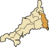
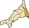
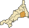
East Wivelshire and West Wivelshire (usually known merely as East and West) are two of the ancient Hundreds of Cornwall
.
East and West (Wivelshire) must have originally had a Cornish name but it is not recorded - see Lost wydhyel
; the second element gwydhyow meaning 'trees' - (Wivel may also be from an Anglo-Saxon personal name 'Wifel'). There are also Anglican deaneries by the same names, but the modern boundaries do not correspond exactly. The area must have formed one hundred originally but had already been divided into two before the Norman Conquest: they are grouped in Domesday under the head manors of Rillaton (East) and Fawton (West). The Cornish names are Ryslegh (East) and Fawy (West).
Hundreds of Cornwall
Cornwall was from Anglo-Saxon times until the 19th century divided into hundreds, some with the suffix shire as in Pydarshire, East and West Wivelshire and Powdershire which were first recorded as names between 1184-1187. In the Cornish language the word for "hundred" is keverang and is the...
.
East and West (Wivelshire) must have originally had a Cornish name but it is not recorded - see Lost wydhyel
Lostwithiel
Lostwithiel is a civil parish and small town in Cornwall, England, United Kingdom at the head of the estuary of the River Fowey. According to the 2001 census it had a population of 2,739...
; the second element gwydhyow meaning 'trees' - (Wivel may also be from an Anglo-Saxon personal name 'Wifel'). There are also Anglican deaneries by the same names, but the modern boundaries do not correspond exactly. The area must have formed one hundred originally but had already been divided into two before the Norman Conquest: they are grouped in Domesday under the head manors of Rillaton (East) and Fawton (West). The Cornish names are Ryslegh (East) and Fawy (West).
East Wivelshire
- Antony St JacobAntony, CornwallAntony is a coastal civil parish and a village in Cornwall, England, United Kingdom.The village is situated on the Rame Peninsula about three miles west of Torpoint and has a shop, a pub and a garage....
, Botus Fleming, Callington, CalstockCalstockCalstock is civil parish and a large village in south east Cornwall, England, United Kingdom, on the border with Devon. The village is situated on the River Tamar south west of Tavistock and north of Plymouth....
, EgloskerryEgloskerryEgloskerry is a village and civil parish in east Cornwall, United Kingdom. It is situated approximately five miles northwest of Launceston....
, LandulphLandulphLandulph is a hamlet and a rural civil parish in south-east Cornwall, United Kingdom. It is situated about 3 miles north of Saltash in the St Germans Registration District....
, LandrakeLandrakeLandrake is a village in southeast Cornwall, United Kingdom. It is situated approximately three miles west of Saltash in the civil parish of Landrake with St Erney...
[with St Erney], LaneastLaneastLaneast is a village and civil parish in Cornwall, United Kingdom. It is situated above the River Inny valley approximately six miles west of Launceston. The population in the 2001 census was 164.-Geography:...
, Launceston St Mary Magdalene, LawhittonLawhittonLawhitton is a civil parish and village in east Cornwall, United Kingdom. The village is situated two miles southwest of Launceston and half-a-mile west of Cornwall's border with Devon at the River Tamar....
, LewannickLewannickLewannick is a civil parish and village in Cornwall, United Kingdom. The village is situated approximately five miles southwest of Launceston. The civil parish has a population of 884....
, LezantLezantLezant is a civil parish and village in east Cornwall, United Kingdom. Lezant village is situated approximately five miles south of Launceston. The population of the parish in the 2001 census was 751.-Geography:...
, LinkinhorneLinkinhorneLinkinhorne is a civil parish and village in southeast Cornwall, United Kingdom. The village itself is situated at and is approximately four miles northwest of Callington and seven miles south of Launceston.-History and geography:As well as Linkinhorne itself, other settlements in the parish...
, MakerMakerMaker is a village between Cawsand and Rame Head, situated on the Rame Peninsula, in Cornwall, United Kingdom.The name means a ruin in Cornish, but another Celtic name is Egloshayle, which means, the church on the estuary, a very apt description of the church's location.The village and its...
, St MellionSt MellionSt Mellion is a village and rural civil parish in east Cornwall, United Kingdom. The parish is three miles south of Callington and is in the St Germans Registration District. The population in the 2001 census was 377...
, MenheniotMenheniotMenheniot is a civil parish and village in Cornwall, United Kingdom. The village is situated 2½ miles southeast of Liskeard. The meaning of the name is "sanctuary of Neot" ....
, North HillNorth Hill, CornwallNorth Hill is a civil parish and village in Cornwall, United Kingdom. The village is situated on the east side of the River Lynher approximately six miles southwest of Launceston....
, PillatonPillatonFor the village in Staffordshire, see Pillaton, StaffordshirePillaton is a village and civil parish in south east Cornwall, England, United Kingdom....
, QuethiockQuethiockQuethiock is a village and civil parish in Cornwall, United Kingdom, roughly five miles east of Liskeard. According to the 2001 census the parish had a population of 429. The ancient parish church of St Hugh is one of the most notable in Cornwall. The placename derives from the Old Cornish cuidoc...
, Rame, SheviockSheviockSheviock is a coastal civil parish and a hamlet in south-east Cornwall, United Kingdom. The parish is two miles south of St Germans and three miles south-west of Saltash....
, South HillSouth Hill, CornwallSouth Hill is a civil parish and village in east Cornwall, United Kingdom.The parish church was consecrated in 1333 and apart from the upper stage of the tower and the south aisle is entirely of this date...
, South PetherwinSouth PetherwinSouth Petherwin is a village and civil parish in east Cornwall, United Kingdom. It is in the Registration District of Launceston. The civil parish is bounded to the north by the Launceston parishes of St Thomas and St Mary Magdalene, to the east by Lawhitton and Lezant parishes and to the west by...
, St Germans, St JohnSt John, CornwallSt John is a coastal civil parish and a village in south-east Cornwall, United Kingdom south of Saltash and south-east of Torpoint.-Geography:...
, St Stephens-with-NewportSt Stephen-by-LauncestonSt Stephens by Launceston Rural is a civil parish in the east of Cornwall, United Kingdom. It is in the Registration district of Launceston. The population of the parish in the 2001 census was 312...
, Stoke ClimslandStoke ClimslandStoke Climsland is a village in the River Tamar Valley, Cornwall, United Kingdom within the civil parish of Stokeclimsland.The manor of Climsland was one of the 17 Antiqua maneria of the Duchy of Cornwall.-Notable buildings:...
, St Dominick, St IveSt IveSt Ive is a village and civil parish in south-east Cornwall, England, United Kingdom. St Ive should not be confused with St Ives, the well-known seaside town in the west of Cornwall...
, St Stephen-by-SaltashSaltashSaltash is a town and civil parish in Cornwall, England, United Kingdom. It has a population of 14,964. It lies in the south east of Cornwall, facing Plymouth over the River Tamar. It was in the Caradon district until March 2009 and is known as "the gateway to Cornwall". Saltash means ash tree by...
, St Thomas Apostle-by-Launceston, TremaineTremaine, CornwallTremaine is a small village and a rural civil parish in east Cornwall, United Kingdom. It is in the Registration District of Launceston and the population in the 2001 census was 87....
, TresmeerTresmeerTresmeer is a hamlet and a civil parish in north-east Cornwall, United Kingdom. The hamlet is situated approximately seven miles north-west of Launceston....
, TrewenTrewenTrewen is a hamlet and a civil parish in east Cornwall, United Kingdom. The parish is just east of Bodmin Moor in the River Inny valley and lies in the Registration District of Launceston....
West Wivelshire
- BoconnocBoconnocBoconnoc is a civil parish in Cornwall, United Kingdom, approximately four miles east of Lostwithiel. According to the 2001 census the parish had a population of 121.The parish is rural in character and is fairly well wooded...
, BraddockBraddock, CornwallBraddock is a village and a civil parish in Cornwall, England, United Kingdom. The village is situated about seven miles west of Liskeard, and five miles south-east of Bodmin....
[Broadoak], CardinhamCardinhamCardinham is a civil parish and a village in central Cornwall, United Kingdom. The village is situated approximately three-and-a-half miles , east-northeast of Bodmin....
, St CleerSt CleerSt Cleer is a civil parish and village in Cornwall, United Kingdom. The village is situated on the southeast flank of Bodmin Moor approximately two miles north of Liskeard....
, DuloeDuloe, CornwallDuloe is a village and civil parish in Cornwall, United Kingdom. It is situated approximately four miles south of Liskeard at .-Parish church:...
, St KeyneSt KeyneSt Keyne is a civil parish and village in Cornwall, United Kingdom. The parish lies between the parishes of Liskeard and Duloe.In Victorian times the holywell in St Keyne had the reputation of conferring supremacy to the marriage partner who first tasted it.The church is dedicated to Saint Keyne...
, LanreathLanreathLanreath is a civil parish and a village in southeast Cornwall, United Kingdom. The village is situated five miles west-northwest of Looe. The name Lanreath means 'church of Raydhogh' and it has been known variously as Lanreythow, Lanrathew, or Lanrethou...
, LansallosLansallosLansallos is a coastal hamlet and a civil parish in south Cornwall, United Kingdom. It is situated between Polruan and Polperro about 5 miles east of Fowey and is in the Liskeard Registration District....
, Lanteglos by Fowey, LiskeardLiskeardLiskeard is an ancient stannary and market town and civil parish in south east Cornwall, England, United Kingdom.Liskeard is situated approximately 20 miles west of Plymouth, west of the River Tamar and the border with Devon, and 12 miles east of Bodmin...
, St Martin-by-LooeSt Martin-by-LooeSt Martin-by-Looe is a coastal civil parish in south Cornwall, United Kingdom. The parish is immediately east of the town and parish of Looe, seven miles south of Liskeard...
, MorvalMorval, CornwallMorval is a rural civil parish and hamlet in south Cornwall, United Kingdom. The hamlet is approximately two miles north of Looe and five miles south of Liskeard....
, St Neot, PelyntPelyntPelynt is a civil parish and village in Cornwall, United Kingdom. It is situated 20 miles west of Plymouth and four miles west-northwest of Looe. Pelynt has a population of around 1,124 ....
, St PinnockSt PinnockSt Pinnock is a hamlet and civil parish in south-east Cornwall, United Kingdom. The parish is in the Liskeard Registration District and the population in the 2001 census was 621....
, TallandTallandTalland is a hamlet and ecclesiastical parish situated between Looe and Polperro on the south coast of Cornwall...
, St VeepSt VeepSt. Veep is a civil parish in Cornwall, United Kingdom situated above the east bank of the Fowey Estuary about three miles southeast of Lostwithiel....
, WarlegganWarlegganWarleggan is a civil parish on the southern edge of Bodmin Moor in Cornwall, England, United Kingdom.The parish is roughly oblong in shape with hamlets near the church and at Mount. The River Warleggan, a tributary of the River Fowey, runs through the parish, forming its western boundary in places...
, St WinnowSt WinnowSt Winnow is a civil parish situated in Cornwall, England, UK. Its name may be connected with either that of Saint Winnoc or Saint Winwaloe. It has a population of 304....