
Williamsport, Maryland
Encyclopedia
Williamsport is a town in Washington County
, Maryland, United States. The population was 1,868 at the 2000 census and 2,278 as of July 2008.
 Williamsport is located at 39°35′55"N 77°49′6"W (39.598496, −77.818464).
According to the United States Census Bureau
, the town has a total area of 1.1 square miles (2.8 km²), all of it land.
Per Mapquest
, Williamsport is located 7.69 miles driving distance SW of Hagerstown, Maryland and 16.23 miles driving distance N of Martinsburg, West Virginia.
, and 0.43% from two or more races. Hispanic or Latino of any race were 0.27% of the population.
There were 785 households out of which 27.0% had children under the age of 18 living with them, 43.7% were married couples living together, 12.0% had a female householder with no husband present, and 40.0% were non-families. 35.7% of all households were made up of individuals and 17.6% had someone living alone who was 65 years of age or older. The average household size was 2.21 and the average family size was 2.84.
In the town the population was spread out with 20.0% under the age of 18, 7.2% from 18 to 24, 26.3% from 25 to 44, 22.8% from 45 to 64, and 23.7% who were 65 years of age or older. The median age was 43 years. For every 100 females there were 80.7 males. For every 100 females age 18 and over, there were 76.5 males.
The median income for a household in the town was $34,243, and the median income for a family was $41,115. Males had a median income of $30,833 versus $21,708 for females. The per capita income for the town was $16,179. About 7.4% of families and 8.5% of the population were below the poverty line, including 4.8% of those under age 18 and 14.8% of those age 65 or over.
from Pennsylvania
to Virginia
and points south and west. In 1744, a ferry was established at the present site of Williamsport to carry the traffic across the Potomac River
. Today’s travelers make the crossing on Interstate 81
a mile downriver from the town.
The actual land of present day Williamsport was owned by American Revolutionary War Otho Holland Williams
, of which the town was named.
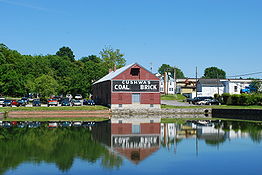
The Chesapeake and Ohio Canal opened in the area of 1834. Williamsport became a very popular waterfront town which benefited the economy. But then after a large flood the canals were shut down for good in 1924. The overflowing flooding waters of the River prevented General Robert E. Lee
's army, on its retreat from Gettysburg
, from crossing and making it safely into Virginia for several days.
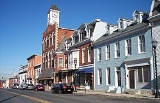
The town's historic core was added to the National Register of Historic Places
as the Williamsport Historic District
in 2001.
The town in May 2010 secured Michael Sparks, a previous town consultant and writer of a revitalization feasibility study, as Director of Economic and Community Development to revitalize downtown and attract tourism. Mr. Sparks outlined a revitalization initiative with the acronym of C.A.R.E.
Over a one year experiment with having a full-time economic development employee hundreds of thousands of grant dollars were secured for projects including handicap accessibility for town buildings, reconstruction of sewage pump stations, a possible bike-and-boat rental facility, and the town was approved as a Heart of the Civil War Heritage Area
Target Investment Zone. Bike lanes, bike racks and directional signage were installed to better direct tourists and connect the town with the Chesapeake and Ohio Canal National Historical Park
. A new permit process was set up with the Washington County, Maryland
permit office, building code enforcement and heavy truck traffic were addressed. Events were coordinated that emphasized revitalization and the downtown merchants. Additionally local youth were honored for community involvement, events were coordinated for town youth and a Boys and Girls Club was created. The changes increased business in Williamsport. The town is part of a regional initiative known as the Canal Towns Partnership.
Washington County, Maryland
Washington County is a county located in the western part of the U.S. state of Maryland, bordering southern Pennsylvania to the north, northern Virginia to the south, and the Eastern Panhandle of West Virginia to the south and west. As of the 2010 Census, its population is 147,430...
, Maryland, United States. The population was 1,868 at the 2000 census and 2,278 as of July 2008.
Geography
According to the United States Census Bureau
United States Census Bureau
The United States Census Bureau is the government agency that is responsible for the United States Census. It also gathers other national demographic and economic data...
, the town has a total area of 1.1 square miles (2.8 km²), all of it land.
Per Mapquest
MapQuest
MapQuest is an American free online web mapping service owned by AOL. The company was founded in 1967 as Cartographic Services, a division of R.R. Donnelley & Sons in Chicago, Illinois, United States. It moved to Lancaster, Pennsylvania in 1969. When it became an independent company in 1994, it was...
, Williamsport is located 7.69 miles driving distance SW of Hagerstown, Maryland and 16.23 miles driving distance N of Martinsburg, West Virginia.
Demographics
As of the census of 2000, there were 1,868 people, 785 households, and 471 families residing in the town. The population density was 1,725.6 people per square mile (667.8/km²). There were 836 housing units at an average density of 772.3 per square mile (298.9/km²). The racial makeup of the town was 98.29% White, 0.80% African American, 0.05% Native American, 0.16% Asian, 0.27% from other racesRace (United States Census)
Race and ethnicity in the United States Census, as defined by the Federal Office of Management and Budget and the United States Census Bureau, are self-identification data items in which residents choose the race or races with which they most closely identify, and indicate whether or not they are...
, and 0.43% from two or more races. Hispanic or Latino of any race were 0.27% of the population.
There were 785 households out of which 27.0% had children under the age of 18 living with them, 43.7% were married couples living together, 12.0% had a female householder with no husband present, and 40.0% were non-families. 35.7% of all households were made up of individuals and 17.6% had someone living alone who was 65 years of age or older. The average household size was 2.21 and the average family size was 2.84.
In the town the population was spread out with 20.0% under the age of 18, 7.2% from 18 to 24, 26.3% from 25 to 44, 22.8% from 45 to 64, and 23.7% who were 65 years of age or older. The median age was 43 years. For every 100 females there were 80.7 males. For every 100 females age 18 and over, there were 76.5 males.
The median income for a household in the town was $34,243, and the median income for a family was $41,115. Males had a median income of $30,833 versus $21,708 for females. The per capita income for the town was $16,179. About 7.4% of families and 8.5% of the population were below the poverty line, including 4.8% of those under age 18 and 14.8% of those age 65 or over.
Famous residents
- Nick AdenhartNick AdenhartNicholas James Adenhart was an American right-handed baseball starting pitcher who played two seasons in Major League Baseball for the Los Angeles Angels of Anaheim...
, deceased MLB pitcher. - Dave ColeDave ColeThis article is about the baseball player. For the artist, see Dave Cole .David Bruce Cole was an American professional baseball player who played six Major league seasons between and ....
, former MLB pitcher. - Gina Marie GrohGina Marie GrohGina Marie Groh is currently a Judge on the 23rd Judicial Circuit Court of West Virginia, a position she has held since 2006. She is also a judicial nominee for the United States District Court for the Northern District of West Virginia...
, Judge
History
The town lies on one of the early Native American trails between New York and the Carolinas. In the mid-18th century, tens of thousands of European settlers and pioneer families with their wagons followed the same route on the Great Wagon RoadGreat Wagon Road
The Great Wagon Road was a colonial American improved trail transiting the Great Appalachian Valley from Pennsylvania to North Carolina, and from there to Georgia....
from Pennsylvania
Pennsylvania
The Commonwealth of Pennsylvania is a U.S. state that is located in the Northeastern and Mid-Atlantic regions of the United States. The state borders Delaware and Maryland to the south, West Virginia to the southwest, Ohio to the west, New York and Ontario, Canada, to the north, and New Jersey to...
to Virginia
Virginia
The Commonwealth of Virginia , is a U.S. state on the Atlantic Coast of the Southern United States. Virginia is nicknamed the "Old Dominion" and sometimes the "Mother of Presidents" after the eight U.S. presidents born there...
and points south and west. In 1744, a ferry was established at the present site of Williamsport to carry the traffic across the Potomac River
Potomac River
The Potomac River flows into the Chesapeake Bay, located along the mid-Atlantic coast of the United States. The river is approximately long, with a drainage area of about 14,700 square miles...
. Today’s travelers make the crossing on Interstate 81
Interstate 81
Interstate 81 is an Interstate Highway in the eastern part of the United States. Its southern terminus is at Interstate 40 in Dandridge, Tennessee; its northern terminus is on Wellesley Island at the Canadian border, where the Thousand Islands Bridge connects it to Highway 401, the main freeway...
a mile downriver from the town.
The actual land of present day Williamsport was owned by American Revolutionary War Otho Holland Williams
Otho Holland Williams
Otho Holland Williams was a Continental Army officer from Maryland in the American Revolutionary War. He participated in many battles throughout the war in the New York, New Jersey and Southern theaters, eventually ending his career as a Brigadier General.Born in rural Prince George's County,...
, of which the town was named.
The Chesapeake and Ohio Canal opened in the area of 1834. Williamsport became a very popular waterfront town which benefited the economy. But then after a large flood the canals were shut down for good in 1924. The overflowing flooding waters of the River prevented General Robert E. Lee
Robert E. Lee
Robert Edward Lee was a career military officer who is best known for having commanded the Confederate Army of Northern Virginia in the American Civil War....
's army, on its retreat from Gettysburg
Battle of Gettysburg
The Battle of Gettysburg , was fought July 1–3, 1863, in and around the town of Gettysburg, Pennsylvania. The battle with the largest number of casualties in the American Civil War, it is often described as the war's turning point. Union Maj. Gen. George Gordon Meade's Army of the Potomac...
, from crossing and making it safely into Virginia for several days.
The town's historic core was added to the National Register of Historic Places
National Register of Historic Places
The National Register of Historic Places is the United States government's official list of districts, sites, buildings, structures, and objects deemed worthy of preservation...
as the Williamsport Historic District
Williamsport Historic District
Williamsport Historic District is a national historic district at Williamsport, Washington County, Maryland, United States. The district consists of the historic core of this town. Almost 20 percent of the buildings in the district date from the late 18th and early 19th centuries. They are...
in 2001.
The town in May 2010 secured Michael Sparks, a previous town consultant and writer of a revitalization feasibility study, as Director of Economic and Community Development to revitalize downtown and attract tourism. Mr. Sparks outlined a revitalization initiative with the acronym of C.A.R.E.
- C-Connecting the various assets of the Town both physically and aesthetically.
- A-Align and inform the merchants with the needs and demographics of tourists.
- R-Rebuild through improving building conditions with Code Enforcement and Ordinance changes.
- E-Entertainment and how to create excitement to pull tourist activity into the town so that it can be built upon and capitalized on by a revitalized Town Center.
Over a one year experiment with having a full-time economic development employee hundreds of thousands of grant dollars were secured for projects including handicap accessibility for town buildings, reconstruction of sewage pump stations, a possible bike-and-boat rental facility, and the town was approved as a Heart of the Civil War Heritage Area
Heart of the Civil War Heritage Area
The Heart of the Civil War Heritage Area is a geographical location recognized by the Maryland Heritage Areas Program. This area includes the Antietam National Battlefield and several other important American Civil War sites in Maryland...
Target Investment Zone. Bike lanes, bike racks and directional signage were installed to better direct tourists and connect the town with the Chesapeake and Ohio Canal National Historical Park
Chesapeake and Ohio Canal National Historical Park
The Chesapeake and Ohio Canal National Historical Park is a United States National Historical Park located in the District of Columbia and the states of Maryland and West Virginia. The park was established as a National Monument in 1961 by President Dwight D...
. A new permit process was set up with the Washington County, Maryland
Washington County, Maryland
Washington County is a county located in the western part of the U.S. state of Maryland, bordering southern Pennsylvania to the north, northern Virginia to the south, and the Eastern Panhandle of West Virginia to the south and west. As of the 2010 Census, its population is 147,430...
permit office, building code enforcement and heavy truck traffic were addressed. Events were coordinated that emphasized revitalization and the downtown merchants. Additionally local youth were honored for community involvement, events were coordinated for town youth and a Boys and Girls Club was created. The changes increased business in Williamsport. The town is part of a regional initiative known as the Canal Towns Partnership.
Highways
-
 Interstate 70Interstate 70Interstate 70 is an Interstate Highway in the United States that runs from Interstate 15 near Cove Fort, Utah, to a Park and Ride near Baltimore, Maryland. It was the first Interstate Highway project in the United States. I-70 approximately traces the path of U.S. Route 40 east of the Rocky...
 -
 Interstate 81Interstate 81Interstate 81 is an Interstate Highway in the eastern part of the United States. Its southern terminus is at Interstate 40 in Dandridge, Tennessee; its northern terminus is on Wellesley Island at the Canadian border, where the Thousand Islands Bridge connects it to Highway 401, the main freeway...
Boys & Girls Clubs of America| -
 U.S. Route 11U.S. Route 11U.S. Route 11 is a north–south United States highway extending 1,645 miles across the eastern United States. The southern terminus of the route is at U.S. Route 90 in the Bayou Sauvage National Wildlife Refuge in eastern New Orleans, Louisiana. The northern terminus is at the United...
 -
 Maryland Route 63Maryland Route 63Maryland Route 63 is a state highway in the U.S. state of Maryland. The state highway runs from MD 65 in Fairplay north to the Pennsylvania state line near Cearfoss, where the highway continues as Pennsylvania Route 163 . MD 63 is an L-shaped route that passes through central Washington County...
 -
 Maryland Route 68Maryland Route 68Maryland Route 68 is a state highway in the U.S. state of Maryland. The state highway runs from U.S. Route 40 in Clear Spring east to US 40 Alternate in Boonsboro. MD 68 crosses central Washington County to the south of Hagerstown, connecting Clear Spring and Boonsboro with Williamsport, where...