

Whitefield, New Hampshire
Encyclopedia
Whitefield is a town
in Coos County
, New Hampshire
, USA, in the White Mountains Region
. The population was 2,306 at the 2010 census. Situated on the northern edge of the White Mountains
, Whitefield is home to the Mount Washington Regional Airport
and the White Mountains Regional High School
.
Whitefield is part of the Berlin
, NH–VT
Micropolitan Statistical Area
. The central village in the town, where 1,142 people resided at the 2010 census, is defined as the Whitefield census-designated place
(CDP) and is located at the junction of U.S. Route 3
, New Hampshire Route 116
and NH Route 142
.
provincial government, Whitefield was chartered on July 4, 1774, exactly two years before adoption of the Declaration of Independence
. Some believe it was named for George Whitefield
, a famous English evangelist
, and a friend of William Legge, 2nd Earl of Dartmouth
, the patron of Dartmouth College
. Others believe the name originated from earlier references to the snowy white fields one would see upon approach through any of the surrounding mountain passages. The chartered name was "Whitefields" but the "s" was dropped on December 1, 1804—the date of incorporation. Early grantees included Jeremy Belknap
, historian, and John Langdon
, who succeeded John Wentworth
as governor.
Whitefield has many fine examples of Victorian architecture
, including a landmark bandstand
built in 1875 on the picturesque common
. With the entrance of the railroad in the 19th century, tourists discovered the town and its cool, clean mountain air. They sought relief from the heat, humidity and pollution of coal-era summers in Boston, Hartford
, New York
and Philadelphia. Several inns and hotels were built to accommodate their increasing numbers. On a hilltop facing the Presidential Range
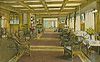
is the grandest, The Mountain View House (now called the Mountain View Grand Resort & Spa), established in 1866. The historic hotel underwent an extensive renovation in the 2000s, and is now one of the most luxurious in New Hampshire.
, the town has a total area of 34.7 square miles (89.9 km²), of which 34.2 sq mi (88.6 km²) is land and 0.4 sq mi (1 km²), or 1.24%, is water. Whitefield is drained by Bog Brook and the Johns River, which runs through the center of town. Forest Lake and the Forest Lake State Park are located along Route 116, west of the town center.
The two highest points in Whitefield are Howland Hill and Kimball Hill, both of which top 1712 feet (521.8 m) above sea level
.
The central village of Whitefield, a census-designated place
, has a total area of 1.3 sq mi (3.4 km²).
 As of the census
of 2000, there were 2,038 people, 819 households, and 547 families residing in the town. The population density
was 59.5 people per square mile (23.0/km²). There were 1,158 housing units at an average density of 13.1 persons/km² (33.8 persons/sq mi). The racial makeup of the town was 98.09% White, 0.20% African American
, 0.34% Native American, 0.34% Asia
n, 0.00% Pacific Islander, 0.29% from other races, and 0.74% from two or more races. 1.13% of the population were Hispanic
or Latino
of any race.
There were 819 households out of which 32.0% had children under the age of 18 living with them, 53.2% were married couples
living together, 9.4% have a woman whose husband does not live with her, and 33.2% were non-families. 27.1% of all households were made up of individuals and 13.3% had someone living alone who was 65 years of age or older. The average household size was 2.40 and the average family size was 2.90.
In the town the population was spread out with 24.3% under the age of 18, 7.5% from 18 to 24, 26.0% from 25 to 44, 23.7% from 45 to 64, and 18.5% who were 65 years of age or older. The median age was 40 years. For every 100 females there were 89.9 males. For every 100 females age 18 and over, there were 90.1 males.
The median income for a household in the town was $34,583, and the median income for a family was $41,528. Males had a median income of $29,293 versus $21,378 for females. The per capita income
for the town was $17,070. 9.8% of the population and 6.1% of families were below the poverty line. Out of the total people living in poverty, 9.8% are under the age of 18 and 13.5% are 65 or older.
of 2000, there were 1,089 people, 433 households, and 272 families residing in the central village of Whitefield, a census-designated place
. The population density
was 845.9 people per square mile (325.9/km²). There were 525 housing units at an average density of 157.1 persons/km² (407.8 persons/sq mi). The racial makeup of the town was 98.26% White, 0.37% African American
, 0.18% Native American, 0.09% Asia
n, and 1.10% from two or more races. 0.64% of the population were Hispanic
or Latino
of any race.
There were 433 households out of which 32.1% had children under the age of 18 living with them, 48.3% were married couples
living together, 10.2% have a woman whose husband does not live with her, and 37.0% were non-families. 31.2% of all households were made up of individuals and 17.6% had someone living alone who was 65 years of age or older. The average household size was 2.36 and the average family size was 2.95.
In the CDP the population was spread out with 24.2% under the age of 18, 8.7% from 18 to 24, 26.1% from 25 to 44, 19.5% from 45 to 64, and 21.5% who were 65 years of age or older. The median age was 39 years. For every 100 females there were 83.6 males. For every 100 females age 18 and over, there were 84.2 males.
The median income for a household is $31,071, and the median income for a family was $38,750. Males had a median income of $28,068 versus $20,375 for females. The per capita income
for the town was $16,217. 10.3% of the population and 7.1% of families were below the poverty line. Out of the total people living in poverty, 11.7% are under the age of 18 and 17.9% are 65 or older.
and U.S. Route 3
and is also served by New Hampshire Route 142
, which leads to Dalton
and points beyond. A seldom-used railroad track of the Maine Central Railroad
runs through town. The Mount Washington Regional Airport
is located in Whitefield. As of January 2006 Whitefield is also served by The Tri-Town Bus, a public transportation route connecting with Lancaster
and Littleton
.
New England town
The New England town is the basic unit of local government in each of the six New England states. Without a direct counterpart in most other U.S. states, New England towns are conceptually similar to civil townships in other states, but are incorporated, possessing powers like cities in other...
in Coos County
Coos County, New Hampshire
-National protected areas:*Umbagog National Wildlife Refuge *Silvio O. Conte National Fish and Wildlife Refuge *White Mountain National Forest -Demographics:...
, New Hampshire
New Hampshire
New Hampshire is a state in the New England region of the northeastern United States of America. The state was named after the southern English county of Hampshire. It is bordered by Massachusetts to the south, Vermont to the west, Maine and the Atlantic Ocean to the east, and the Canadian...
, USA, in the White Mountains Region
White Mountains Region
The White Mountains Region is a tourism region designated by the New Hampshire Division of Travel and Tourism. It is located in northern New Hampshire in the United States and is named for the White Mountains, which cover most of the region. The southern boundary of the region begins at Piermont...
. The population was 2,306 at the 2010 census. Situated on the northern edge of the White Mountains
White Mountains (New Hampshire)
The White Mountains are a mountain range covering about a quarter of the state of New Hampshire and a small portion of western Maine in the United States. Part of the Appalachian Mountains, they are considered the most rugged mountains in New England...
, Whitefield is home to the Mount Washington Regional Airport
Mount Washington Regional Airport
Mount Washington Regional Airport is a public airport located east of downtown Whitefield in Coos County, New Hampshire, USA. The Civil Air Patrol maintains a composite squadron at this location....
and the White Mountains Regional High School
High school
High school is a term used in parts of the English speaking world to describe institutions which provide all or part of secondary education. The term is often incorporated into the name of such institutions....
.
Whitefield is part of the Berlin
Berlin, New Hampshire
Berlin is a city along the Androscoggin River in Coos County in northern New Hampshire, United States. The population was 10,051 at the 2010 census. It includes the village of Cascade. Located on the edge of the White Mountains, the city's boundaries extend into the White Mountain National Forest...
, NH–VT
Vermont
Vermont is a state in the New England region of the northeastern United States of America. The state ranks 43rd in land area, , and 45th in total area. Its population according to the 2010 census, 630,337, is the second smallest in the country, larger only than Wyoming. It is the only New England...
Micropolitan Statistical Area
Berlin micropolitan area
The Berlin Micropolitan Statistical Area is the core based statistical area centered on the urban cluster associated with the city Berlin, New Hampshire in the United States...
. The central village in the town, where 1,142 people resided at the 2010 census, is defined as the Whitefield census-designated place
Census-designated place
A census-designated place is a concentration of population identified by the United States Census Bureau for statistical purposes. CDPs are delineated for each decennial census as the statistical counterparts of incorporated places such as cities, towns and villages...
(CDP) and is located at the junction of U.S. Route 3
U.S. Route 3
U.S. Route 3 is a north–south United States highway that runs from its southern terminus in Cambridge, Massachusetts through New Hampshire to its terminus near Third Connecticut Lake at the Canadian border, where the road continues north as Quebec Route 257.In New Hampshire parts of US 3 are...
, New Hampshire Route 116
New Hampshire Route 116
New Hampshire Route 116 is a long east–west highway in northern New Hampshire. NH 116 is a scenic rural highway stretching from Haverhill, which lies along the Connecticut River, to Jefferson, in the White Mountains Region....
and NH Route 142
New Hampshire Route 142
New Hampshire Route 142 is a long north–south state highway in northern New Hampshire. The highway runs between Franconia in the White Mountains Region to Dalton in the upper Connecticut River valley....
.
History
The last town to be granted under the EnglishEngland
England is a country that is part of the United Kingdom. It shares land borders with Scotland to the north and Wales to the west; the Irish Sea is to the north west, the Celtic Sea to the south west, with the North Sea to the east and the English Channel to the south separating it from continental...
provincial government, Whitefield was chartered on July 4, 1774, exactly two years before adoption of the Declaration of Independence
Declaration of independence
A declaration of independence is an assertion of the independence of an aspiring state or states. Such places are usually declared from part or all of the territory of another nation or failed nation, or are breakaway territories from within the larger state...
. Some believe it was named for George Whitefield
George Whitefield
George Whitefield , also known as George Whitfield, was an English Anglican priest who helped spread the Great Awakening in Britain, and especially in the British North American colonies. He was one of the founders of Methodism and of the evangelical movement generally...
, a famous English evangelist
Evangelism
Evangelism refers to the practice of relaying information about a particular set of beliefs to others who do not hold those beliefs. The term is often used in reference to Christianity....
, and a friend of William Legge, 2nd Earl of Dartmouth
William Legge, 2nd Earl of Dartmouth
William Legge 2nd Earl of Dartmouth PC, FRS , styled as Viscount Lewisham from 1732 to 1750, was a British statesman who is most remembered for his part in the government before and during the American Revolution....
, the patron of Dartmouth College
Dartmouth College
Dartmouth College is a private, Ivy League university in Hanover, New Hampshire, United States. The institution comprises a liberal arts college, Dartmouth Medical School, Thayer School of Engineering, and the Tuck School of Business, as well as 19 graduate programs in the arts and sciences...
. Others believe the name originated from earlier references to the snowy white fields one would see upon approach through any of the surrounding mountain passages. The chartered name was "Whitefields" but the "s" was dropped on December 1, 1804—the date of incorporation. Early grantees included Jeremy Belknap
Jeremy Belknap
Jeremy Belknap was an American clergyman and historian. His great achievement was the "History of New Hampshire", published in three volumes between 1784 and 1792. This work is the first modern history written by an American, embodying a new rigor in research, annotation, and reporting.Jeremy was...
, historian, and John Langdon
John Langdon
John Langdon was a politician from Portsmouth, New Hampshire, and one of the first two United States senators from that state. Langdon was an early supporter of the Revolutionary War and later served in the Continental Congress...
, who succeeded John Wentworth
John Wentworth (governor)
Sir John Wentworth, 1st Baronet was the British colonial governor of New Hampshire at the time of the American Revolution. He was later also Lieutenant-Governor of Nova Scotia.-Early life:...
as governor.
Whitefield has many fine examples of Victorian architecture
Victorian architecture
The term Victorian architecture refers collectively to several architectural styles employed predominantly during the middle and late 19th century. The period that it indicates may slightly overlap the actual reign, 20 June 1837 – 22 January 1901, of Queen Victoria. This represents the British and...
, including a landmark bandstand
Bandstand
A bandstand is a circular or semicircular structure set in a park, garden, pier, or indoor space, designed to accommodate musical bands performing concerts...
built in 1875 on the picturesque common
Common land
Common land is land owned collectively or by one person, but over which other people have certain traditional rights, such as to allow their livestock to graze upon it, to collect firewood, or to cut turf for fuel...
. With the entrance of the railroad in the 19th century, tourists discovered the town and its cool, clean mountain air. They sought relief from the heat, humidity and pollution of coal-era summers in Boston, Hartford
Hartford, Connecticut
Hartford is the capital of the U.S. state of Connecticut. The seat of Hartford County until Connecticut disbanded county government in 1960, it is the second most populous city on New England's largest river, the Connecticut River. As of the 2010 Census, Hartford's population was 124,775, making...
, New York
New York City
New York is the most populous city in the United States and the center of the New York Metropolitan Area, one of the most populous metropolitan areas in the world. New York exerts a significant impact upon global commerce, finance, media, art, fashion, research, technology, education, and...
and Philadelphia. Several inns and hotels were built to accommodate their increasing numbers. On a hilltop facing the Presidential Range
Presidential Range
The Presidential Range is a mountain range located in the White Mountains of the U.S. state of New Hampshire. Containing the highest peaks of the Whites, its most notable summits are named for American Presidents, followed by prominent public figures of the 18th and 19th centuries.Mt...
is the grandest, The Mountain View House (now called the Mountain View Grand Resort & Spa), established in 1866. The historic hotel underwent an extensive renovation in the 2000s, and is now one of the most luxurious in New Hampshire.
Geography
According to the United States Census BureauUnited States Census Bureau
The United States Census Bureau is the government agency that is responsible for the United States Census. It also gathers other national demographic and economic data...
, the town has a total area of 34.7 square miles (89.9 km²), of which 34.2 sq mi (88.6 km²) is land and 0.4 sq mi (1 km²), or 1.24%, is water. Whitefield is drained by Bog Brook and the Johns River, which runs through the center of town. Forest Lake and the Forest Lake State Park are located along Route 116, west of the town center.
The two highest points in Whitefield are Howland Hill and Kimball Hill, both of which top 1712 feet (521.8 m) above sea level
Sea level
Mean sea level is a measure of the average height of the ocean's surface ; used as a standard in reckoning land elevation...
.
The central village of Whitefield, a census-designated place
Census-designated place
A census-designated place is a concentration of population identified by the United States Census Bureau for statistical purposes. CDPs are delineated for each decennial census as the statistical counterparts of incorporated places such as cities, towns and villages...
, has a total area of 1.3 sq mi (3.4 km²).
Demographics
Census
A census is the procedure of systematically acquiring and recording information about the members of a given population. It is a regularly occurring and official count of a particular population. The term is used mostly in connection with national population and housing censuses; other common...
of 2000, there were 2,038 people, 819 households, and 547 families residing in the town. The population density
Population density
Population density is a measurement of population per unit area or unit volume. It is frequently applied to living organisms, and particularly to humans...
was 59.5 people per square mile (23.0/km²). There were 1,158 housing units at an average density of 13.1 persons/km² (33.8 persons/sq mi). The racial makeup of the town was 98.09% White, 0.20% African American
African American
African Americans are citizens or residents of the United States who have at least partial ancestry from any of the native populations of Sub-Saharan Africa and are the direct descendants of enslaved Africans within the boundaries of the present United States...
, 0.34% Native American, 0.34% Asia
Asia
Asia is the world's largest and most populous continent, located primarily in the eastern and northern hemispheres. It covers 8.7% of the Earth's total surface area and with approximately 3.879 billion people, it hosts 60% of the world's current human population...
n, 0.00% Pacific Islander, 0.29% from other races, and 0.74% from two or more races. 1.13% of the population were Hispanic
Hispanic
Hispanic is a term that originally denoted a relationship to Hispania, which is to say the Iberian Peninsula: Andorra, Gibraltar, Portugal and Spain. During the Modern Era, Hispanic sometimes takes on a more limited meaning, particularly in the United States, where the term means a person of ...
or Latino
Latino
The demonyms Latino and Latina , are defined in English language dictionaries as:* "a person of Latin-American descent."* "A Latin American."* "A person of Hispanic, especially Latin-American, descent, often one living in the United States."...
of any race.
There were 819 households out of which 32.0% had children under the age of 18 living with them, 53.2% were married couples
Marriage
Marriage is a social union or legal contract between people that creates kinship. It is an institution in which interpersonal relationships, usually intimate and sexual, are acknowledged in a variety of ways, depending on the culture or subculture in which it is found...
living together, 9.4% have a woman whose husband does not live with her, and 33.2% were non-families. 27.1% of all households were made up of individuals and 13.3% had someone living alone who was 65 years of age or older. The average household size was 2.40 and the average family size was 2.90.
In the town the population was spread out with 24.3% under the age of 18, 7.5% from 18 to 24, 26.0% from 25 to 44, 23.7% from 45 to 64, and 18.5% who were 65 years of age or older. The median age was 40 years. For every 100 females there were 89.9 males. For every 100 females age 18 and over, there were 90.1 males.
The median income for a household in the town was $34,583, and the median income for a family was $41,528. Males had a median income of $29,293 versus $21,378 for females. The per capita income
Per capita income
Per capita income or income per person is a measure of mean income within an economic aggregate, such as a country or city. It is calculated by taking a measure of all sources of income in the aggregate and dividing it by the total population...
for the town was $17,070. 9.8% of the population and 6.1% of families were below the poverty line. Out of the total people living in poverty, 9.8% are under the age of 18 and 13.5% are 65 or older.
Town center
As of the censusCensus
A census is the procedure of systematically acquiring and recording information about the members of a given population. It is a regularly occurring and official count of a particular population. The term is used mostly in connection with national population and housing censuses; other common...
of 2000, there were 1,089 people, 433 households, and 272 families residing in the central village of Whitefield, a census-designated place
Census-designated place
A census-designated place is a concentration of population identified by the United States Census Bureau for statistical purposes. CDPs are delineated for each decennial census as the statistical counterparts of incorporated places such as cities, towns and villages...
. The population density
Population density
Population density is a measurement of population per unit area or unit volume. It is frequently applied to living organisms, and particularly to humans...
was 845.9 people per square mile (325.9/km²). There were 525 housing units at an average density of 157.1 persons/km² (407.8 persons/sq mi). The racial makeup of the town was 98.26% White, 0.37% African American
African American
African Americans are citizens or residents of the United States who have at least partial ancestry from any of the native populations of Sub-Saharan Africa and are the direct descendants of enslaved Africans within the boundaries of the present United States...
, 0.18% Native American, 0.09% Asia
Asia
Asia is the world's largest and most populous continent, located primarily in the eastern and northern hemispheres. It covers 8.7% of the Earth's total surface area and with approximately 3.879 billion people, it hosts 60% of the world's current human population...
n, and 1.10% from two or more races. 0.64% of the population were Hispanic
Hispanic
Hispanic is a term that originally denoted a relationship to Hispania, which is to say the Iberian Peninsula: Andorra, Gibraltar, Portugal and Spain. During the Modern Era, Hispanic sometimes takes on a more limited meaning, particularly in the United States, where the term means a person of ...
or Latino
Latino
The demonyms Latino and Latina , are defined in English language dictionaries as:* "a person of Latin-American descent."* "A Latin American."* "A person of Hispanic, especially Latin-American, descent, often one living in the United States."...
of any race.
There were 433 households out of which 32.1% had children under the age of 18 living with them, 48.3% were married couples
Marriage
Marriage is a social union or legal contract between people that creates kinship. It is an institution in which interpersonal relationships, usually intimate and sexual, are acknowledged in a variety of ways, depending on the culture or subculture in which it is found...
living together, 10.2% have a woman whose husband does not live with her, and 37.0% were non-families. 31.2% of all households were made up of individuals and 17.6% had someone living alone who was 65 years of age or older. The average household size was 2.36 and the average family size was 2.95.
In the CDP the population was spread out with 24.2% under the age of 18, 8.7% from 18 to 24, 26.1% from 25 to 44, 19.5% from 45 to 64, and 21.5% who were 65 years of age or older. The median age was 39 years. For every 100 females there were 83.6 males. For every 100 females age 18 and over, there were 84.2 males.
The median income for a household is $31,071, and the median income for a family was $38,750. Males had a median income of $28,068 versus $20,375 for females. The per capita income
Per capita income
Per capita income or income per person is a measure of mean income within an economic aggregate, such as a country or city. It is calculated by taking a measure of all sources of income in the aggregate and dividing it by the total population...
for the town was $16,217. 10.3% of the population and 7.1% of families were below the poverty line. Out of the total people living in poverty, 11.7% are under the age of 18 and 17.9% are 65 or older.
Transportation
Whitefield is at the intersections of New Hampshire Route 116New Hampshire Route 116
New Hampshire Route 116 is a long east–west highway in northern New Hampshire. NH 116 is a scenic rural highway stretching from Haverhill, which lies along the Connecticut River, to Jefferson, in the White Mountains Region....
and U.S. Route 3
U.S. Route 3
U.S. Route 3 is a north–south United States highway that runs from its southern terminus in Cambridge, Massachusetts through New Hampshire to its terminus near Third Connecticut Lake at the Canadian border, where the road continues north as Quebec Route 257.In New Hampshire parts of US 3 are...
and is also served by New Hampshire Route 142
New Hampshire Route 142
New Hampshire Route 142 is a long north–south state highway in northern New Hampshire. The highway runs between Franconia in the White Mountains Region to Dalton in the upper Connecticut River valley....
, which leads to Dalton
Dalton, New Hampshire
Dalton is a town in Coos County, New Hampshire, United States. The population was 979 at the 2010 census. It is part of the Berlin, NH–VT Micropolitan Statistical Area.- History :...
and points beyond. A seldom-used railroad track of the Maine Central Railroad
Maine Central Railroad
The Maine Central Railroad Company was a railroad in central and southern Maine. It was chartered in 1856 and began operations in 1862. It operated a mainline between South Portland, Maine, east to the Canada-U.S...
runs through town. The Mount Washington Regional Airport
Mount Washington Regional Airport
Mount Washington Regional Airport is a public airport located east of downtown Whitefield in Coos County, New Hampshire, USA. The Civil Air Patrol maintains a composite squadron at this location....
is located in Whitefield. As of January 2006 Whitefield is also served by The Tri-Town Bus, a public transportation route connecting with Lancaster
Lancaster, New Hampshire
Lancaster is a town in Coos County, New Hampshire, USA, on the Connecticut River named after Lancaster, England. As of the 2010 census, the town population was 3,507, the second largest in the county after Berlin. It is the county seat of Coos County and gateway to the Great North Woods Region...
and Littleton
Littleton, New Hampshire
Littleton is a town in Grafton County, New Hampshire, United States. The population was 5,928 at the 2010 census. Situated at the edge of the White Mountains, Littleton is bounded on the northwest by the Connecticut River....
.
Sites of interest
- Mountain View Grand Resort and Spa
- Old Mill Studio
- Weathervane Theatre
- Whitefield Historical Society Museum