
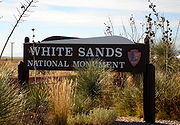
White Sands National Monument
Encyclopedia
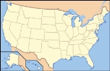
The White Sands National Monument is a U.S. National Monument
located about 25 km (15.5 mi) southwest of Alamogordo
in western Otero County
and northeastern Dona Ana County
in the state
of New Mexico
, at an elevation of 4235 feet (1291 m). The area is in the mountain-ringed Tularosa Basin
valley area and comprises the southern part of a 710-km² (275-mi²) field of white sand dunes composed of gypsum
crystals.
The Mescalero Apache were already living in the area at the time. Hispanic families started farming communities in the area at Tularosa in 1861 and at La Luz in 1863.
 The idea of creating a national park here goes back at least to 1898, when a group in El Paso
proposed a Mescalero National Park. Their idea was for a game hunting preserve, which conflicted with the idea of preservation held by the Department of the Interior, and their plan was not successful. In 1921-1922 Albert Bacon Fall, United States Secretary of the Interior
and owner of a large ranch in Three Rivers
near White Sands, promoted the idea of a national park there, an "All-Year National Park" that, unlike more northerly parks, would be usable year-round. This idea ran into a number of difficulties and did not succeed. Tom Charles, an Alamogordo insurance agent and civic booster, was influenced by Fall's ideas. By emphasizing the economic benefits, Charles was able to mobilize enough support to have the park created.
On January 18, 1933, President Herbert Hoover
created the White Sands National Monument, acting under the authority of the Antiquities Act
of 1906. The dedication and grand opening was on April 29, 1934.
The Headquarters building (also called the Visitor Center Complex) was constructed of adobe bricks as a Works Progress Administration
project starting in 1936 and completed in 1938.
The Monument is completely surrounded by military installations (White Sands Missile Range
and Holloman Air Force Base
) and has always had an uneasy relationship with the military. Errant missiles often fell on WSNM property, in some cases destroying some of the visitor areas. Overflights from Holloman disturbed the tranquility of the area.
In 1969 the New Mexico Department of Game and Fish introduced oryx
into the Tularosa Basin
, intending them to be hunted for sport. The oryx had no natural predators; they invaded WSNM and competed with the native species for forage.
s on January 22, 2008.
The state's two U.S. Senators, Pete Domenici
and Jeff Bingaman
, wrote letters of support of the application.
U.S. Representative Stevan Pearce declined to support the application, saying, "I would guarantee that if White Sands Monument receives this designation, that there will at some point be international pressures exerted that could stop military operations as we know them today."
The WHS application generated much controversy in Otero County
, most of it taking place in meetings of the Otero County Commission. A petition with 1,200 signatures opposing the application was presented to the Commission on August 16, 2007.
The Commission on August 23, 2007 passed a resolution of opposition to the application,
and on October 18, 2007 passed Ordinance 07-05 that purports to make it illegal for WSNM to become a World Heritage Site.
On January 24, 2008, after the Tentative List was announced, the Commission instructed the County Attorney to write a letter to the Secretary of the Interior, demanding that WSNM be taken off the list.
 Gypsum is rarely found in the form of sand because it is water-soluble. Normally, rain would dissolve the gypsum and carry it to the sea. The Tularosa Basin is enclosed, meaning that it has no outlet to the sea and that rain that dissolves gypsum from the surrounding San Andres
and Sacramento Mountains
is trapped within the basin. Thus water either sinks into the ground or forms shallow pools which subsequently dry out and leave gypsum in a crystalline form, called selenite, on the surface. Groundwater that does flow out of the Tularosa Basin flows south into the Hueco Basin.
During the last ice age
, a lake known as Lake Otero covered much of the basin. When it dried out, it left a large flat area of selenite crystals which is now the Alkali Flat. Another lake, Lake Lucero, at the southwest corner of the park, is a dry lake bed, at one of the lowest points of the basin, which occasionally fills with water.
The ground in the Alkali Flat and along Lake Lucero's shore is covered with selenite crystals which reach lengths of up to three feet (1 m). Weathering
and erosion
eventually breaks the crystals into sand-size grains that are carried away by the prevailing winds from the southwest, forming white dunes. The dunes constantly change shape and slowly move downwind. Since gypsum is water-soluble, the sand that composes the dunes may dissolve and cement
together after rain, forming a layer of sand that is more solid and could affect wind resistance of dunes.
This resistance does not prevent dunes from quickly covering the plants in their path. Some species of plants, however, can grow fast enough to avoid being buried by the dunes.
Various forms of dune
s are found within the limits of White Sands. Dome dunes are found along the southwest margins of the field, transverse and barchan
in the core of the field, and parabolic dunes occur in high numbers along the northern, southern, and northeastern margins.
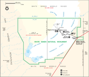
From the visitor center at the entrance of the park, the Dunes Drive leads 8 miles (12.9 km) into the dunes. Four marked trails allow one to explore the dunes by foot. During the summer, there are also Ranger-guided orientation and nature walks. The park participates in the Junior Ranger Program
, with various age-group-specific activities http://www.nps.gov/whsa/forkids/beajuniorranger.htm.
Unlike dunes made of quartz-based sand crystals, the gypsum does not readily convert the sun's energy into heat and thus can be walked upon safely with bare feet, even in the hottest summer months. In areas accessible by car, children frequently use the dunes for downhill sledding.
Because the park lies completely within the White Sands Missile Range
, both the park and U.S. Route 70
between Las Cruces, New Mexico
and Alamogordo
are subject to closure for safety reasons when tests are conducted on the missile range. On average, tests occur about twice a week, for a duration of one to two hours. Located on the northernmost boundaries of White Sands Missile Range
, the Trinity Site can be found, where the first atom bomb was detonated.
U.S. National Monument
A National Monument in the United States is a protected area that is similar to a National Park except that the President of the United States can quickly declare an area of the United States to be a National Monument without the approval of Congress. National monuments receive less funding and...
located about 25 km (15.5 mi) southwest of Alamogordo
Alamogordo, New Mexico
Alamogordo is the county seat of Otero County and a city in south-central New Mexico, United States. A desert community lying in the Tularosa Basin, it is bordered on the east by the Sacramento Mountains. It is the nearest city to Holloman Air Force Base. The population was 35,582 as of the 2000...
in western Otero County
Otero County, New Mexico
-2010:Whereas according to the 2010 U.S. Census Bureau:*72.7% White*3.5% Black*6.7% Native American*1.2% Asian*0.2% Native Hawaiian or Pacific Islander*4.2% Two or more races*11.2% Other races*34.5% Hispanic or Latino -2000:...
and northeastern Dona Ana County
Doña Ana County, New Mexico
-2010:Whereas according to the 2010 U.S. Census Bureau:*74.1% White*1.7% Black*1.5% Native American*1.1% Asian*0.1% Native Hawaiian or Pacific Islander*3.0% Two or more races*18.5% Other races*65.7% Hispanic or Latino -2000:...
in the state
U.S. state
A U.S. state is any one of the 50 federated states of the United States of America that share sovereignty with the federal government. Because of this shared sovereignty, an American is a citizen both of the federal entity and of his or her state of domicile. Four states use the official title of...
of New Mexico
New Mexico
New Mexico is a state located in the southwest and western regions of the United States. New Mexico is also usually considered one of the Mountain States. With a population density of 16 per square mile, New Mexico is the sixth-most sparsely inhabited U.S...
, at an elevation of 4235 feet (1291 m). The area is in the mountain-ringed Tularosa Basin
Tularosa Basin
The Tularosa Basin is a graben basin in the Basin and Range Province and within the Chihuahuan Desert, east of the Rio Grande in southern New Mexico, in the Southwestern United States.-Geography:...
valley area and comprises the southern part of a 710-km² (275-mi²) field of white sand dunes composed of gypsum
Gypsum
Gypsum is a very soft sulfate mineral composed of calcium sulfate dihydrate, with the chemical formula CaSO4·2H2O. It is found in alabaster, a decorative stone used in Ancient Egypt. It is the second softest mineral on the Mohs Hardness Scale...
crystals.
History
The first exploration was led by a party of US Army officers in 1849.The Mescalero Apache were already living in the area at the time. Hispanic families started farming communities in the area at Tularosa in 1861 and at La Luz in 1863.
Preparation for a National Park
El Paso
El Paso, a city in the U.S. state of Texas, on the border with Mexico.El Paso may also refer to:-Geography:Colombia:* El Paso, CesarSpain:*El Paso, Santa Cruz de TenerifeUnited States:...
proposed a Mescalero National Park. Their idea was for a game hunting preserve, which conflicted with the idea of preservation held by the Department of the Interior, and their plan was not successful. In 1921-1922 Albert Bacon Fall, United States Secretary of the Interior
United States Secretary of the Interior
The United States Secretary of the Interior is the head of the United States Department of the Interior.The US Department of the Interior should not be confused with the concept of Ministries of the Interior as used in other countries...
and owner of a large ranch in Three Rivers
Three Rivers, New Mexico
Three Rivers is an unincorporated community in Otero County, United States. Its elevation is 4,570 feet .-Notable people:*Virginia Klinekole, first female president of the Mescalero Apache, 1959*Sara Misquez, president of the Mescalero Apache...
near White Sands, promoted the idea of a national park there, an "All-Year National Park" that, unlike more northerly parks, would be usable year-round. This idea ran into a number of difficulties and did not succeed. Tom Charles, an Alamogordo insurance agent and civic booster, was influenced by Fall's ideas. By emphasizing the economic benefits, Charles was able to mobilize enough support to have the park created.
On January 18, 1933, President Herbert Hoover
Herbert Hoover
Herbert Clark Hoover was the 31st President of the United States . Hoover was originally a professional mining engineer and author. As the United States Secretary of Commerce in the 1920s under Presidents Warren Harding and Calvin Coolidge, he promoted partnerships between government and business...
created the White Sands National Monument, acting under the authority of the Antiquities Act
Antiquities Act
The Antiquities Act of 1906, officially An Act for the Preservation of American Antiquities , is an act passed by the United States Congress and signed into law by Theodore Roosevelt on June 8, 1906, giving the President of the United States authority to, by executive order, restrict the use of...
of 1906. The dedication and grand opening was on April 29, 1934.
Life as a National Monument
Tom Charles became the first custodian of the monument, and upon his retirement in 1939 became the first concessionaire, operating as White Sands Service Company.The Headquarters building (also called the Visitor Center Complex) was constructed of adobe bricks as a Works Progress Administration
Works Progress Administration
The Works Progress Administration was the largest and most ambitious New Deal agency, employing millions of unskilled workers to carry out public works projects, including the construction of public buildings and roads, and operated large arts, drama, media, and literacy projects...
project starting in 1936 and completed in 1938.
The Monument is completely surrounded by military installations (White Sands Missile Range
White Sands Missile Range
White Sands Missile Range is a rocket range of almost in parts of five counties in southern New Mexico. The largest military installation in the United States, WSMR includes the and the WSMR Otera Mesa bombing range...
and Holloman Air Force Base
Holloman Air Force Base
Holloman Air Force Base is a United States Air Force base located six miles southwest of the central business district of Alamogordo, a city in Otero County, New Mexico, United States. The base was named in honor of Col. George V. Holloman, a pioneer in guided missile research...
) and has always had an uneasy relationship with the military. Errant missiles often fell on WSNM property, in some cases destroying some of the visitor areas. Overflights from Holloman disturbed the tranquility of the area.
In 1969 the New Mexico Department of Game and Fish introduced oryx
Oryx
Oryx is one of four large antelope species of the genus Oryx. Three of the species are native to arid parts of Africa, with a fourth native to the Arabian Peninsula. Their pelage is pale with contrasing dark markings in the face and on the legs, and their long horns are almost straight...
into the Tularosa Basin
Tularosa Basin
The Tularosa Basin is a graben basin in the Basin and Range Province and within the Chihuahuan Desert, east of the Rio Grande in southern New Mexico, in the Southwestern United States.-Geography:...
, intending them to be hunted for sport. The oryx had no natural predators; they invaded WSNM and competed with the native species for forage.
World Heritage Site controversy
WSNM was placed on the Tentative List of World Heritage SiteWorld Heritage Site
A UNESCO World Heritage Site is a place that is listed by the UNESCO as of special cultural or physical significance...
s on January 22, 2008.
The state's two U.S. Senators, Pete Domenici
Pete Domenici
Pietro Vichi "Pete" Domenici is an American Republican politician, who served six terms as a United States Senator from New Mexico, from 1973 to 2009, the longest tenure in the state's history....
and Jeff Bingaman
Jeff Bingaman
Jesse Francis "Jeff" Bingaman, Jr. , is the senior U.S. Senator from New Mexico and a member of the Democratic Party...
, wrote letters of support of the application.
U.S. Representative Stevan Pearce declined to support the application, saying, "I would guarantee that if White Sands Monument receives this designation, that there will at some point be international pressures exerted that could stop military operations as we know them today."
The WHS application generated much controversy in Otero County
Otero County, New Mexico
-2010:Whereas according to the 2010 U.S. Census Bureau:*72.7% White*3.5% Black*6.7% Native American*1.2% Asian*0.2% Native Hawaiian or Pacific Islander*4.2% Two or more races*11.2% Other races*34.5% Hispanic or Latino -2000:...
, most of it taking place in meetings of the Otero County Commission. A petition with 1,200 signatures opposing the application was presented to the Commission on August 16, 2007.
The Commission on August 23, 2007 passed a resolution of opposition to the application,
and on October 18, 2007 passed Ordinance 07-05 that purports to make it illegal for WSNM to become a World Heritage Site.
On January 24, 2008, after the Tentative List was announced, the Commission instructed the County Attorney to write a letter to the Secretary of the Interior, demanding that WSNM be taken off the list.
Description
San Andres Mountains
The San Andres Mountains are a mountain range in the southwestern U.S. state of New Mexico, in the counties of Socorro, Sierra, and Doña Ana. The range extends about 75 miles north to south, but are only about 12 miles wide at their widest...
and Sacramento Mountains
Sacramento Mountains
The Sacramento Mountains are a mountain range in the south-central part of the U.S. state of New Mexico, lying just east of Alamogordo in Otero County...
is trapped within the basin. Thus water either sinks into the ground or forms shallow pools which subsequently dry out and leave gypsum in a crystalline form, called selenite, on the surface. Groundwater that does flow out of the Tularosa Basin flows south into the Hueco Basin.
During the last ice age
Ice age
An ice age or, more precisely, glacial age, is a generic geological period of long-term reduction in the temperature of the Earth's surface and atmosphere, resulting in the presence or expansion of continental ice sheets, polar ice sheets and alpine glaciers...
, a lake known as Lake Otero covered much of the basin. When it dried out, it left a large flat area of selenite crystals which is now the Alkali Flat. Another lake, Lake Lucero, at the southwest corner of the park, is a dry lake bed, at one of the lowest points of the basin, which occasionally fills with water.
The ground in the Alkali Flat and along Lake Lucero's shore is covered with selenite crystals which reach lengths of up to three feet (1 m). Weathering
Weathering
Weathering is the breaking down of rocks, soils and minerals as well as artificial materials through contact with the Earth's atmosphere, biota and waters...
and erosion
Erosion
Erosion is when materials are removed from the surface and changed into something else. It only works by hydraulic actions and transport of solids in the natural environment, and leads to the deposition of these materials elsewhere...
eventually breaks the crystals into sand-size grains that are carried away by the prevailing winds from the southwest, forming white dunes. The dunes constantly change shape and slowly move downwind. Since gypsum is water-soluble, the sand that composes the dunes may dissolve and cement
Cementation (geology)
Cementation involves ions carried in groundwater chemically precipitating to form new crystalline material within sediment pores; this is how "sediment" becomes "rock". The new pore-filling minerals form "bridges" between original sediment grains, thereby binding them together. So sand becomes...
together after rain, forming a layer of sand that is more solid and could affect wind resistance of dunes.
This resistance does not prevent dunes from quickly covering the plants in their path. Some species of plants, however, can grow fast enough to avoid being buried by the dunes.
Various forms of dune
Dune
In physical geography, a dune is a hill of sand built by wind. Dunes occur in different forms and sizes, formed by interaction with the wind. Most kinds of dunes are longer on the windward side where the sand is pushed up the dune and have a shorter "slip face" in the lee of the wind...
s are found within the limits of White Sands. Dome dunes are found along the southwest margins of the field, transverse and barchan
Barchan
A barchan dune, also barkhan is an arc-shaped sand ridge, comprising well-sorted sand. This type of dune possesses two "horns" that face downwind, with the slip face at the angle of repose of sand, or approximately 35 degrees . The upwind side is packed by the wind, and stands at about 15 degrees...
in the core of the field, and parabolic dunes occur in high numbers along the northern, southern, and northeastern margins.
From the visitor center at the entrance of the park, the Dunes Drive leads 8 miles (12.9 km) into the dunes. Four marked trails allow one to explore the dunes by foot. During the summer, there are also Ranger-guided orientation and nature walks. The park participates in the Junior Ranger Program
Junior Ranger Program
The "Junior Ranger Programs" are activities prepared especially for 5–12 year old visitors to the properties of the National Park Service. Children and their families participate in the program by completing prepared activity books which are generally free, but in a few cases can cost up to $3...
, with various age-group-specific activities http://www.nps.gov/whsa/forkids/beajuniorranger.htm.
Unlike dunes made of quartz-based sand crystals, the gypsum does not readily convert the sun's energy into heat and thus can be walked upon safely with bare feet, even in the hottest summer months. In areas accessible by car, children frequently use the dunes for downhill sledding.
Because the park lies completely within the White Sands Missile Range
White Sands Missile Range
White Sands Missile Range is a rocket range of almost in parts of five counties in southern New Mexico. The largest military installation in the United States, WSMR includes the and the WSMR Otera Mesa bombing range...
, both the park and U.S. Route 70
U.S. Route 70
U.S. Route 70 is an east–west United States highway that runs for 2,385 miles from eastern North Carolina to east-central Arizona. As can be derived from its number, it is a major east–west highway of the Southern and Southwestern United States...
between Las Cruces, New Mexico
Las Cruces, New Mexico
Las Cruces, also known as "The City of the Crosses", is the county seat of Doña Ana County, New Mexico, United States. The population was 97,618 in 2010 according to the 2010 Census, making it the second largest city in the state....
and Alamogordo
Alamogordo, New Mexico
Alamogordo is the county seat of Otero County and a city in south-central New Mexico, United States. A desert community lying in the Tularosa Basin, it is bordered on the east by the Sacramento Mountains. It is the nearest city to Holloman Air Force Base. The population was 35,582 as of the 2000...
are subject to closure for safety reasons when tests are conducted on the missile range. On average, tests occur about twice a week, for a duration of one to two hours. Located on the northernmost boundaries of White Sands Missile Range
White Sands Missile Range
White Sands Missile Range is a rocket range of almost in parts of five counties in southern New Mexico. The largest military installation in the United States, WSMR includes the and the WSMR Otera Mesa bombing range...
, the Trinity Site can be found, where the first atom bomb was detonated.
Media references
- White Sands National Monument appears in the opening scenes of the 1978 Sam PeckinpahSam PeckinpahDavid Samuel "Sam" Peckinpah was an American filmmaker and screenwriter who achieved prominence following the release of the Western epic The Wild Bunch...
movie, Convoy.
External links
- National Park Service: official White Sands National Monument website
- White Sands National Monument: detailed Map (pdf format)
- White Sands National Monument: "White Sands" (1938 film) — White Sands (film)White Sands (film)White Sands is a 1992 motion picture directed by Roger Donaldson and written by Daniel Pyne for Warner Bros. The movie is about a U.S. southwestern small-town sheriff who finds a body in the desert with a suitcase and $500,000. He impersonates the man and stumbles into an FBI investigation...
- Migrating dunes "Deactivation" (under the influence of vegetation)