
White Nile
Encyclopedia
The White Nile is a river
of Africa
, one of the two main tributaries
of the Nile
from Egypt
, the other being the Blue Nile
. In the strict meaning, "White Nile" refers to the river formed at Lake No
at the confluence of the Bahr al Jabal
and Bahr el Ghazal rivers. In the wider sense, "White Nile" refers to the approximately 3700 kilometres (2,299.1 mi) of rivers draining from Lake Victoria
into the White Nile proper. It may also, depending on the speaker, refer to the headwaters of Lake Victoria
.
The 19th century search by Europeans for the source of the Nile was mainly focused on the White Nile, which disappeared into the depths of what was then known as "Darkest Africa". The discovery of the source of the White Nile thus came to symbolise European penetration of unknown jungle.
 The Kagera River
, which flows into Lake Victoria near the Tanzanian town of Bukoba
, is the longest feeder river for Lake Victoria, although sources do not agree on which is the longest tributary of the Kagera and hence the most distant source of the Nile itself. It is either the Ruvyironza
, which emerges in Bururi Province
, Burundi
, or the Nyabarongo, which flows from Nyungwe Forest
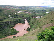
in Rwanda. The two feeder rivers meet near Rusumo Falls
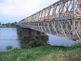
on the Rwanda-Tanzania border. The falls are notable because of an event on 28–29 April 1994, when 250,000 Rwandans crossed the bridge at Rusumo Falls into Ngara
, Tanzania
, in 24 hours in what the United Nations High Commissioner for Refugees
called "the largest and fastest refugee exodus in modern times." The Kagera forms part of the Rwanda
–Tanzania and Tanzania–Uganda
borders before flowing into Lake Victoria
.
 The river arising from Lake Victoria is known as the Victoria Nile. It arises just outside Jinja. There is a monument at the spot. After Nalubaale Power Station
and Kiira Power Station
at the mouth, the river goes through Bujagali Falls
(location of Bujagali Power Station
) about 15 kilometres downstream from Jinja
. It then flows north and westwards through Uganda
, feeding into Lake Kyoga
in the centre of the country and then out west. At Karuma Falls, the river sweeps under Karuma Bridge (2°14′45.40"N 32°15′9.05"E) at the southeastern corner of Murchison Falls National Park
. During much of the insurgency of the Lord's Resistance Army
, Karuma Bridge, built in 1963 to help the cotton industry, was the key stop on the way to Gulu
, where vehicles would gather in convoy before being provided with a military escort for the final run north. In 2009, the Government of Uganda announced plans to construct a 750MW hydropower project several kilometres north of the bridge, which is scheduled for completion in 2016. The World Bank
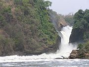
had approved to fund a smaller 200MW power plant but Uganda opted for a bigger project, which the Ugandans will fund internally. Just before entering Lake Albert, the river is compressed into a passage seven metres in width at Murchison Falls
, marking the entry into the western branch of the Great Rift Valley
. The river flows into Lake Albert opposite the Blue Mountains
in the Democratic Republic of the Congo
.
The river exiting Lake Albert to the north is known as the Albert Nile. The river separates the West Nile sub-region
of Uganda from the rest of the nation. While a bridge passes over the Albert Nile near its inlet in Nebbi District
, there is no other bridge over this section. A powered ferry connects the roads between Adjumani
and Moyo
, but navigation of the river is otherwise done by small boat or canoe.
where it enters South Sudan
and becomes known as the Bahr al Jabal ("River of the Mountain"). Bahr al Jabal was the former name of the state of Central Equatoria
. The Bahr al Jabal then winds through rapids before entering the Sudan plain and the vast swamp of the Sudd
. It eventually makes its way to Lake No
, where it merges with the Bahr el Ghazal and forms the White Nile. An anabranch
river called Bahr el Zeraf
flows out of the Bahr al Jabal and flows through the Sudd to eventually join the White Nile. The Bahr al Jabal passes through Juba
, the capital of South Sudan
, and the southernmost navigable point on the Nile river system, and then Kodok
, the site of the 1898 Fashoda Incident
that marked an end to the "Scramble for Africa
".
and lends its name to the state
of White Nile
, before merging with the larger Blue Nile
at Khartoum
, the capital of Sudan
, and forming the River Nile.
River
A river is a natural watercourse, usually freshwater, flowing towards an ocean, a lake, a sea, or another river. In a few cases, a river simply flows into the ground or dries up completely before reaching another body of water. Small rivers may also be called by several other names, including...
of Africa
Africa
Africa is the world's second largest and second most populous continent, after Asia. At about 30.2 million km² including adjacent islands, it covers 6% of the Earth's total surface area and 20.4% of the total land area...
, one of the two main tributaries
Tributary
A tributary or affluent is a stream or river that flows into a main stem river or a lake. A tributary does not flow directly into a sea or ocean...
of the Nile
Nile
The Nile is a major north-flowing river in North Africa, generally regarded as the longest river in the world. It is long. It runs through the ten countries of Sudan, South Sudan, Burundi, Rwanda, Democratic Republic of the Congo, Tanzania, Kenya, Ethiopia, Uganda and Egypt.The Nile has two major...
from Egypt
Egypt
Egypt , officially the Arab Republic of Egypt, Arabic: , is a country mainly in North Africa, with the Sinai Peninsula forming a land bridge in Southwest Asia. Egypt is thus a transcontinental country, and a major power in Africa, the Mediterranean Basin, the Middle East and the Muslim world...
, the other being the Blue Nile
Blue Nile
The Blue Nile is a river originating at Lake Tana in Ethiopia. With the White Nile, the river is one of the two major tributaries of the Nile...
. In the strict meaning, "White Nile" refers to the river formed at Lake No
Lake No
Lake No is a lake in South Sudan. It is located just north of the vast swamp of the Sudd, at the confluence of the Bahr al Jabal and Bahr el Ghazal rivers. It marks the transition between the Bahr al Jabal and White Nile proper. Lake No is located approximately 1,156 km downstream of Uganda's...
at the confluence of the Bahr al Jabal
Bahr al Jabal
Bahr al Jabal may refer to:* Bahr al Jabal, a section of the White Nile between Nimule and Lake No* Bahr al Jabal, a state of Southern Sudan renamed Central Equatoria in 2005...
and Bahr el Ghazal rivers. In the wider sense, "White Nile" refers to the approximately 3700 kilometres (2,299.1 mi) of rivers draining from Lake Victoria
Lake Victoria
Lake Victoria is one of the African Great Lakes. The lake was named for Queen Victoria of the United Kingdom, by John Hanning Speke, the first European to discover this lake....
into the White Nile proper. It may also, depending on the speaker, refer to the headwaters of Lake Victoria
Lake Victoria
Lake Victoria is one of the African Great Lakes. The lake was named for Queen Victoria of the United Kingdom, by John Hanning Speke, the first European to discover this lake....
.
The 19th century search by Europeans for the source of the Nile was mainly focused on the White Nile, which disappeared into the depths of what was then known as "Darkest Africa". The discovery of the source of the White Nile thus came to symbolise European penetration of unknown jungle.
Headwaters of Lake Victoria
Kagera River
The Kagera River, also Akagera River, is an East African river, forming part of the upper headwaters of the Nile and carrying water from its most distant source....
, which flows into Lake Victoria near the Tanzanian town of Bukoba
Bukoba
Bukoba is a town in northwest Tanzania on the western shore of Lake Victoria. It is the capital of the Kagera region. Population estimate: 100,000...
, is the longest feeder river for Lake Victoria, although sources do not agree on which is the longest tributary of the Kagera and hence the most distant source of the Nile itself. It is either the Ruvyironza
Ruvyironza River
The Ruvyironza River is a river in Africa which is the most remote source of the Nile, the world's longest river. It rises in Burundi, and flows into the Kagera River in Tanzania, and from there into Lake Victoria.- References :...
, which emerges in Bururi Province
Bururi Province
Bururi is one of the seventeen provinces of Burundi. It is also the largest. It includes the city of Bururi, the provincial capital, and the city of Rumonge which sits on the shores of Lake Tanganyika...
, Burundi
Burundi
Burundi , officially the Republic of Burundi , is a landlocked country in the Great Lakes region of Eastern Africa bordered by Rwanda to the north, Tanzania to the east and south, and the Democratic Republic of the Congo to the west. Its capital is Bujumbura...
, or the Nyabarongo, which flows from Nyungwe Forest
Nyungwe Forest
Nyungwe Forest National Park is a national park in southwestern Rwanda, located south of Lake Kivu on the border with Burundi. The park was established in 2004 and covers an area of approximately 970 km² of rainforest, bamboo, grassland, swamps, and bogs. The nearest town is Cyangugu, 54 km to the...
in Rwanda. The two feeder rivers meet near Rusumo Falls
Rusumo Falls
Rusumo Falls is a waterfall located on the Kagera river on the border between Rwanda and Tanzania, part of the most distant headwaters of the river Nile...
on the Rwanda-Tanzania border. The falls are notable because of an event on 28–29 April 1994, when 250,000 Rwandans crossed the bridge at Rusumo Falls into Ngara
Ngara
Ngara is one of the six districts of the Kagera Region of Tanzania. It is bordered to the north by the Karagwe District, to the east by the Biharamulo District, to the south by the Kigoma Region, to the northeast by the Muleba District and to the west by Rwanda and Burundi.According to the 2002...
, Tanzania
Tanzania
The United Republic of Tanzania is a country in East Africa bordered by Kenya and Uganda to the north, Rwanda, Burundi, and the Democratic Republic of the Congo to the west, and Zambia, Malawi, and Mozambique to the south. The country's eastern borders lie on the Indian Ocean.Tanzania is a state...
, in 24 hours in what the United Nations High Commissioner for Refugees
United Nations High Commissioner for Refugees
The Office of the United Nations High Commissioner for Refugees , also known as The UN Refugee Agency is a United Nations agency mandated to protect and support refugees at the request of a government or the UN itself and assists in their voluntary repatriation, local integration or resettlement to...
called "the largest and fastest refugee exodus in modern times." The Kagera forms part of the Rwanda
Rwanda
Rwanda or , officially the Republic of Rwanda , is a country in central and eastern Africa with a population of approximately 11.4 million . Rwanda is located a few degrees south of the Equator, and is bordered by Uganda, Tanzania, Burundi and the Democratic Republic of the Congo...
–Tanzania and Tanzania–Uganda
Uganda
Uganda , officially the Republic of Uganda, is a landlocked country in East Africa. Uganda is also known as the "Pearl of Africa". It is bordered on the east by Kenya, on the north by South Sudan, on the west by the Democratic Republic of the Congo, on the southwest by Rwanda, and on the south by...
borders before flowing into Lake Victoria
Lake Victoria
Lake Victoria is one of the African Great Lakes. The lake was named for Queen Victoria of the United Kingdom, by John Hanning Speke, the first European to discover this lake....
.
In Uganda
Nalubaale Power Station
Nalubaale Power Station, often known by its old name, Owen Falls Dam, is a hydroelectric power station across the White Nile near to its source at Lake Victoria in Uganda...
and Kiira Power Station
Kiira Power Station
Kiira Power Station, sometimes spelled Kiyira Power Station, is a hydroelectric power station with an installed capacity of 200MW, in Uganda.-Location:...
at the mouth, the river goes through Bujagali Falls
Bujagali falls
Bujagali Falls is a waterfall near Jinja in Uganda where the Nile River comes out of Lake Victoria, sometimes considered the source of the Nile.-Proposed dam:...
(location of Bujagali Power Station
Bujagali Power Station
-Location:The power station is located across the Victoria Nile, about north of Jinja immediately north of the former location of Bujagali Falls. This location lies at the border between Buikwe District to the west and Jinja District to the east...
) about 15 kilometres downstream from Jinja
Jinja, Uganda
Jinja is the largest town in Uganda, Africa. It is the second busiest commercial center in the country, after Kampala, Uganda's capital and only city. Jinja was established in 1907.-Location:...
. It then flows north and westwards through Uganda
Uganda
Uganda , officially the Republic of Uganda, is a landlocked country in East Africa. Uganda is also known as the "Pearl of Africa". It is bordered on the east by Kenya, on the north by South Sudan, on the west by the Democratic Republic of the Congo, on the southwest by Rwanda, and on the south by...
, feeding into Lake Kyoga
Lake Kyoga
Lake Kyoga is a large shallow lake complex of Uganda, about in area and at an elevation of 914 m. The Victoria Nile flows through the lake on its way from Lake Victoria to Lake Albert. The main inflow from Lake Victoria is regulated by the Nalubaale Power Station in Jinja. Another source of water...
in the centre of the country and then out west. At Karuma Falls, the river sweeps under Karuma Bridge (2°14′45.40"N 32°15′9.05"E) at the southeastern corner of Murchison Falls National Park
Murchison Falls National Park
Murchison Falls National Park is a national park in Uganda. The park lies in north western Uganda, spreading inland from the shore of Lake Albert around the Victoria Nile. It is named for the Murchison Falls waterfall, itself named for a president of the Royal Geographical Society...
. During much of the insurgency of the Lord's Resistance Army
Lord's Resistance Army
The Lord's Resistance Army insurgency is an ongoing guerrilla campaign waged since 1987 by the Lord's Resistance Army rebel group, operating mainly in northern Uganda, but also in South Sudan and eastern Democratic Republic of the Congo...
, Karuma Bridge, built in 1963 to help the cotton industry, was the key stop on the way to Gulu
Gulu
Gulu is a city in Northern Uganda. It is the commercial and administrative centre of Gulu District. The city is located at 2˚46'48N 32˚18'00E, on the metre gauge railway from Tororo to Pakwach. Gulu is located approximately , by road, north of Kampala, Uganda's capital and largest city...
, where vehicles would gather in convoy before being provided with a military escort for the final run north. In 2009, the Government of Uganda announced plans to construct a 750MW hydropower project several kilometres north of the bridge, which is scheduled for completion in 2016. The World Bank
World Bank
The World Bank is an international financial institution that provides loans to developing countries for capital programmes.The World Bank's official goal is the reduction of poverty...
had approved to fund a smaller 200MW power plant but Uganda opted for a bigger project, which the Ugandans will fund internally. Just before entering Lake Albert, the river is compressed into a passage seven metres in width at Murchison Falls
Murchison Falls
Murchison Falls, also known as Kabarega Falls, is a waterfall on the Nile. It breaks the Victoria Nile, which flows across northern Uganda from Lake Victoria to Lake Kyoga and then to the north end of Lake Albert in the western branch of the East African Rift....
, marking the entry into the western branch of the Great Rift Valley
Great Rift Valley
The Great Rift Valley is a name given in the late 19th century by British explorer John Walter Gregory to the continuous geographic trench, approximately in length, that runs from northern Syria in Southwest Asia to central Mozambique in South East Africa...
. The river flows into Lake Albert opposite the Blue Mountains
Blue Mountains (Congo)
The Blue Mountains are a mountain range located in the northeastern Ituri Province of the Democratic Republic of the Congo. To the east the range overlooks Lake Albert, at the confluence of the Victoria Nile and Albert Nile, which form part of the border with Uganda...
in the Democratic Republic of the Congo
Democratic Republic of the Congo
The Democratic Republic of the Congo is a state located in Central Africa. It is the second largest country in Africa by area and the eleventh largest in the world...
.
The river exiting Lake Albert to the north is known as the Albert Nile. The river separates the West Nile sub-region
West Nile sub-region
West Nile sub-region is a region in north-western Uganda that consists of the districts of Adjumani, Arua, Koboko, Maracha-Terego, Moyo, Nebbi and Yumbe...
of Uganda from the rest of the nation. While a bridge passes over the Albert Nile near its inlet in Nebbi District
Nebbi District
Nebbi District is a district in Northern Uganda. It is named after its main municipal, commercial and administrative centre, Nebbi, the location of the district headquarters.-Location:...
, there is no other bridge over this section. A powered ferry connects the roads between Adjumani
Adjumani
Adjumani is a town in Northern Uganda. It is the 'chief town' of Adjumani District and the district headquarters are located there.-Location:Adjumani is located approximately , by road, northeast of Arua, the largest city in the sub-region. This location lies approximately , north of Kampala, the...
and Moyo
Moyo Town
Moyo, is the main municipal, administrative and commercial center of Moyo District in Northern Uganda. The district headquarters are located here. The district is named after the town.-Location:...
, but navigation of the river is otherwise done by small boat or canoe.
In South Sudan
The river continues north to NimuleNimule
Nimule is a town in South Sudan, immediately north of the International border with Uganda.-Location:Nimule is located in Magwi County, Eastern Equatoria State, South Sudan, adjacent to the border with the Republic of Uganda. This location lies approximately , by road, southeast of Juba, the...
where it enters South Sudan
South Sudan
South Sudan , officially the Republic of South Sudan, is a landlocked country located in the Sahel region of northeastern Africa. It is also part of the North Africa UN sub-region. Its current capital is Juba, which is also its largest city; the capital city is planned to be moved to the more...
and becomes known as the Bahr al Jabal ("River of the Mountain"). Bahr al Jabal was the former name of the state of Central Equatoria
Central Equatoria
-Government:Executive*Governor - Maj. Gen. Clement Wani Konga*Deputy Governor and Minister of Education, Science and Technology - Mr. Manase Lomole Waya *Minister of Education - Lokulenge Lole Lokule...
. The Bahr al Jabal then winds through rapids before entering the Sudan plain and the vast swamp of the Sudd
Sudd
The Sudd , also known as the Bahr al Jabal, As Sudd or Al Sudd, is a vast swamp in South Sudan, formed by the White Nile. The word “sudd” is derived from the Arabic word “sadd”, meaning “block.” The term has come to refer to any large solid floating vegetation island or mat...
. It eventually makes its way to Lake No
Lake No
Lake No is a lake in South Sudan. It is located just north of the vast swamp of the Sudd, at the confluence of the Bahr al Jabal and Bahr el Ghazal rivers. It marks the transition between the Bahr al Jabal and White Nile proper. Lake No is located approximately 1,156 km downstream of Uganda's...
, where it merges with the Bahr el Ghazal and forms the White Nile. An anabranch
Anabranch
An anabranch is a section of a river or stream that diverts from the main channel or stem of the watercourse and rejoins the main stem downstream. Local anabranches can be the result of small islands in the watercourse...
river called Bahr el Zeraf
Bahr el Zeraf
The Bahr el Zeraf is an arm of the White Nile in the Sudd region of South Sudan, Africa. It is completely contained within the South Sudanese state of Jonglei...
flows out of the Bahr al Jabal and flows through the Sudd to eventually join the White Nile. The Bahr al Jabal passes through Juba
Juba
- Locations :* Juba, the capital of South Sudan* Juba, Estonia, a village in Võru Parish, Võru County, Estonia- People :* Juba I of Numidia * Juba II of Numidia * Juba of Mauretania...
, the capital of South Sudan
South Sudan
South Sudan , officially the Republic of South Sudan, is a landlocked country located in the Sahel region of northeastern Africa. It is also part of the North Africa UN sub-region. Its current capital is Juba, which is also its largest city; the capital city is planned to be moved to the more...
, and the southernmost navigable point on the Nile river system, and then Kodok
Kodok
Kodok is a town in the northeastern South Sudanese state of Upper Nile. Kodok is the capital of Shilluk country, formally known as Shilluk Kingdom. Shilluk has been an independent kingdom for more than sixteen centuries...
, the site of the 1898 Fashoda Incident
Fashoda Incident
The Fashoda Incident was the climax of imperial territorial disputes between Britain and France in Eastern Africa. A French expedition to Fashoda on the White Nile sought to gain control of the Nile River and thereby force Britain out of Egypt. The British held firm as Britain and France were on...
that marked an end to the "Scramble for Africa
Scramble for Africa
The Scramble for Africa, also known as the Race for Africa or Partition of Africa was a process of invasion, occupation, colonization and annexation of African territory by European powers during the New Imperialism period, between 1881 and World War I in 1914...
".
In Sudan
The river flows north into SudanSudan
Sudan , officially the Republic of the Sudan , is a country in North Africa, sometimes considered part of the Middle East politically. It is bordered by Egypt to the north, the Red Sea to the northeast, Eritrea and Ethiopia to the east, South Sudan to the south, the Central African Republic to the...
and lends its name to the state
States of Sudan
Below is a list of the 15 states of Sudan, organized by their original provinces during the period of Anglo-Egyptian Sudan. Arabic language versions are, as appropriate, in parentheses. States that were not provinces before 1994 are marked with . Transliterations from Arabic to English may vary;...
of White Nile
White Nile (state)
White Nile is one of the 15 wilayat or states of Sudan. It has an area of 30,411 km2 and an estimated population of approximately 1,188,707 . Since 1994 Rabak is the capital of the state; other important cities include Kosti and Ed Dueim....
, before merging with the larger Blue Nile
Blue Nile
The Blue Nile is a river originating at Lake Tana in Ethiopia. With the White Nile, the river is one of the two major tributaries of the Nile...
at Khartoum
Khartoum
Khartoum is the capital and largest city of Sudan and of Khartoum State. It is located at the confluence of the White Nile flowing north from Lake Victoria, and the Blue Nile flowing west from Ethiopia. The location where the two Niles meet is known as "al-Mogran"...
, the capital of Sudan
Sudan
Sudan , officially the Republic of the Sudan , is a country in North Africa, sometimes considered part of the Middle East politically. It is bordered by Egypt to the north, the Red Sea to the northeast, Eritrea and Ethiopia to the east, South Sudan to the south, the Central African Republic to the...
, and forming the River Nile.