
Whipple Mountains
Encyclopedia
The Whipple Mountains, 'Avii Kur'utat in the Mojave language
, are located in eastern San Bernardino County, California
. They are directly west of the Colorado River
, Parker Dam
, and Lake Havasu
; south of Needles, California
; north of Parker, Arizona
and Vidal, California
; and northeast of Vidal Junction, California
.
The mountain forms a major direction change of the north-south Colorado, as it changes directions to southeast, then southwest around the eastern perimeter of the Whipple Mountains. The highest point of the mountains, and the Whipple Mountains Wilderness
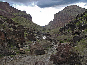
is Whipple Mountain at 4131 feet (1,259 m). The western portion of the mountain range has pale green formations, differing from the eastern, steeply carved and striking brick-red volcanics. Landforms are diverse and range from valley floors and washes to steep-walled canyons, domed peaks, natural bridges, and eroded spires.
, the northwestern section of the Sonoran Desert
, and in the Lower Colorado River Valley
region. The Turtle Mountains are to the west, the Mopah Range
adjacent on the south, and the Chemehuevi Mountains
upriver to the north. Whipple Peak is the highest point in the range at an elevation of 4,131 ft; it lies west of the range's center, and Whipple Wash flows northeast from the peak.
The following United States Geological Survey
(USGS) 7.5' Quadrangle maps provide coverage of the Whipple Mountains:
 The present-day landform of the Whipple Mountains is a series of sub-parallel ridges trending northwest to southeast, cut at right angles by a large wash
, (Whipple Wash), which bisects the entire range. These linear ridges mark the tops of tilted crustal blocks lying in the hanging wall of an extensive detachment fault
, and the range as a whole comprises one of the best exposed and most studied metamorphic core complex
es in the world.
In the western half of the range, the hanging wall has been eroded away completely, leaving antiformally upwarped lower-crustal mylonite
s exposed at the surface. To the east, unaltered tertiary
volcanic and sedimenatary rocks along with non-mylonitic crystalline Pre-Cambrian rock in the hanging wall form the land surface, but the larger washes provide access to the detachment surface and the rocks surrounding it. Excellent examples of hydrothermal alteration
, fluidized cataclasite
injection, and other mid- and upper-crustal fault processes abound along the detachment surface. A number of high-angle normal faults accommodating tilting and extension within the hanging wall are easily visible as well.
The Whipple detachment fault is part of a larger complex of shallow, east dipping normal faults extending from the Whipples northward to the southern tip of Nevada
, where a transition occurs to shallow, westward dipping normal faults. The entire region accommodated major crustal extension between the Sierra Nevada block and the Colorado Plateau
during the early and middle Miocene
. Upwards of 40 km of extension occurred in a region now 70 to 100 km across. The Whipples are part of the Maria fold and thrust belt
.
, and other Native American
cultural tribes and groups lived in and traveled through the Whipples for thousands of years.
Francisco Garcés
, the explorer, missionary, and regional "peacemaker" based at Mission San Xavier del Bac
had initiated expeditons along the river and surrounding terrain through and past the Whipples in the early 1770s. In 1774 he joined the famous Juan Bautista de Anza
Las Californias
Expediton from "mainland New Spain
to the "new to them" Alta California
. They passed through the range en-route to the Needles area and onwards inland, traveling in peace with the local indigenous people west of the river. In the early 1900s Wyatt Earp
spent his last winters here working small gold and copper mining claims, starting around 1906. The nearby townsite of Earp, California
on and near those claims was named for him, although his residence actually stands in the town of Vidal, California
.
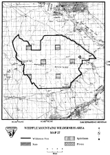
Currently, portions of the range within and without the Whipple Mountains Wilderness Area are owned by the State of California or private land owners. Access to these areas is not by the BLM, but the other owners and agencies.
, administered by the Needles Field office of the United States Bureau of Land Management
. The wilderness covers approximately 76122 acres (30,805.5 ha) of the range.
Mojave language
Mojave is the native language of the Mohave people along the Colorado River in eastern California, northwestern Arizona, and southwestern Nevada...
, are located in eastern San Bernardino County, California
San Bernardino County, California
San Bernardino County is a county in the U.S. state of California. As of the 2010 census, the population was 2,035,210, up from 1,709,434 as of the 2000 census...
. They are directly west of the Colorado River
Colorado River
The Colorado River , is a river in the Southwestern United States and northwestern Mexico, approximately long, draining a part of the arid regions on the western slope of the Rocky Mountains. The watershed of the Colorado River covers in parts of seven U.S. states and two Mexican states...
, Parker Dam
Parker Dam
Parker Dam is a concrete arch-gravity dam that crosses the Colorado River downstream of Hoover Dam. Built between 1934 and 1938 by the Bureau of Reclamation, it is high, of which are below the riverbed, making it "the deepest dam in the world". The dam's primary functions are to create a...
, and Lake Havasu
Lake Havasu
Lake Havasu is a large reservoir behind Parker Dam on the Colorado River, on the border between California and Arizona. Lake Havasu City sits on the lake's eastern shore. The lake has a capacity of . The concrete arch dam was built by the United States Bureau of Reclamation between 1934 and 1938...
; south of Needles, California
Needles, California
Needles is a city located in the Mojave Desert on the western banks of the Colorado River in San Bernardino County, California. It is located in the Mohave Valley, which straddles the California–Arizona border. The city is accessible via Interstate 40 and U.S. Route 95...
; north of Parker, Arizona
Parker, Arizona
Parker is a town in and the county seat of La Paz County, Arizona, United States, on the Colorado River in Parker Valley. The population was 3,140 at the 2000 census.-History:...
and Vidal, California
Vidal, California
Vidal, California is a small Unincorporated community located in southeastern California, in San Bernardino County on U.S. Route 95, north of Blythe, California and south of Needles. The town is west of the townsite of Earp, California and west of Parker, Arizona on State Highway 62. The town...
; and northeast of Vidal Junction, California
Vidal Junction, California
Vidal Junction, California is a small town site in the Sonoran Desert in unincorporated San Bernardino County, California, United States.The town is near the California/Arizona state line immediately west of Parker at the intersection of U.S. Route 95 and State Route 62 a short distance north of...
.
The mountain forms a major direction change of the north-south Colorado, as it changes directions to southeast, then southwest around the eastern perimeter of the Whipple Mountains. The highest point of the mountains, and the Whipple Mountains Wilderness
Whipple Mountains Wilderness
The Whipple Mountains Wilderness is a wilderness administered by the Bureau of Land Management . Most of the Whipple Mountains are within the wilderness area. It is located in the northeastern Colorado Desert near the Colorado River. Lake Havasu and Lake Havasu City are to the south . Earp,...
is Whipple Mountain at 4131 feet (1,259 m). The western portion of the mountain range has pale green formations, differing from the eastern, steeply carved and striking brick-red volcanics. Landforms are diverse and range from valley floors and washes to steep-walled canyons, domed peaks, natural bridges, and eroded spires.
Geography
The range stretches approximately 25 miles (40.2 km) in an east-west direction, and reaches an elevation of 2695 feet (821.4 m) at Savahia Peak at the western end. The Whipple Mountains are home to many mines including the Independence Mine and Bessie Mine. The range lies in the Colorado DesertColorado Desert
California's Colorado Desert is a part of the larger Sonoran Desert, which extends across southwest North America. The Colorado Desert region encompasses approximately , reaching from the Mexican border in the south to the higher-elevation Mojave Desert in the north and from the Colorado River in...
, the northwestern section of the Sonoran Desert
Sonoran Desert
The Sonoran Desert is a North American desert which straddles part of the United States-Mexico border and covers large parts of the U.S. states of Arizona and California and the northwest Mexican states of Sonora, Baja California, and Baja California Sur. It is one of the largest and hottest...
, and in the Lower Colorado River Valley
Lower Colorado River Valley
The Lower Colorado River Valley is the river region of the lower Colorado River of the southwestern United States in North America that rises in the Rocky Mountains and has its outlet at the Colorado River Delta in the northern Sea of Cortez in northwestern Mexico, between the states of Baja...
region. The Turtle Mountains are to the west, the Mopah Range
Mopah Range
The Mopah Range is a desert mountain range, in the Lower Colorado River Valley region, in southeastern San Bernardino County, California.-Geography:The Mopah Range are located directly adjacent to and linked with the larger Turtle Mountains Range...
adjacent on the south, and the Chemehuevi Mountains
Chemehuevi Mountains
The Chemehuevi Mountains are found at the southeast border of San Bernardino County in southeastern California adjacent the Colorado River. Located south of Needles, California and northwest of the Whipple Mountains, the mountains lie in a north-south direction in general, and are approximately 15...
upriver to the north. Whipple Peak is the highest point in the range at an elevation of 4,131 ft; it lies west of the range's center, and Whipple Wash flows northeast from the peak.
The following United States Geological Survey
United States Geological Survey
The United States Geological Survey is a scientific agency of the United States government. The scientists of the USGS study the landscape of the United States, its natural resources, and the natural hazards that threaten it. The organization has four major science disciplines, concerning biology,...
(USGS) 7.5' Quadrangle maps provide coverage of the Whipple Mountains:
- Gene Wash
- Havasu Lake
- Lake Havasu City South
- Parker
- Parker NW
- Savahia Peak
- Whipple Mountains SW
- Whipple Wash
Climate
Data from the Western Regional Climate Center reveals this to be a region of extreme aridity (<150 mm/yr), very high summer temperatures (+40 °C) and mild winter temperatures.Geology
Wash
Wash may refer to:* Arroyo , also called a wash, a dry creek bed or gulch that temporarily fills with water after a heavy rain* WASH, a water, sanitation and hygiene advocacy campaign initiated by the Water Supply and Sanitation Collaborative Council...
, (Whipple Wash), which bisects the entire range. These linear ridges mark the tops of tilted crustal blocks lying in the hanging wall of an extensive detachment fault
Detachment fault
Detachment faulting is associated with large-scale extensional tectonics. Detachment faults often have very large displacements and juxtapose unmetamorphosed hanging walls against medium to high-grade metamorphic footwalls that are called metamorphic core complexes...
, and the range as a whole comprises one of the best exposed and most studied metamorphic core complex
Metamorphic core complex
Metamorphic core complexes are exposures of deep crust exhumed in association with largely amagmatic extension. They form, and are exhumed, through relatively fast transport of middle and lower continental crust to the Earth's surface...
es in the world.
In the western half of the range, the hanging wall has been eroded away completely, leaving antiformally upwarped lower-crustal mylonite
Mylonite
Mylonite is a fine-grained, compact rock produced by dynamic recrystallization of the constituent minerals resulting in a reduction of the grain size of the rock. It is classified as a metamorphic rock...
s exposed at the surface. To the east, unaltered tertiary
Tertiary
The Tertiary is a deprecated term for a geologic period 65 million to 2.6 million years ago. The Tertiary covered the time span between the superseded Secondary period and the Quaternary...
volcanic and sedimenatary rocks along with non-mylonitic crystalline Pre-Cambrian rock in the hanging wall form the land surface, but the larger washes provide access to the detachment surface and the rocks surrounding it. Excellent examples of hydrothermal alteration
Metamorphism
Metamorphism is the solid-state recrystallization of pre-existing rocks due to changes in physical and chemical conditions, primarily heat, pressure, and the introduction of chemically active fluids. Mineralogical, chemical and crystallographic changes can occur during this process...
, fluidized cataclasite
Cataclasite
Cataclasite is a type of cataclastic rock that is formed by fracturing and comminution during faulting. It is normally cohesive and non-foliated, consisting of angular clasts in a finer-grained matrix.- Types of cataclasite :...
injection, and other mid- and upper-crustal fault processes abound along the detachment surface. A number of high-angle normal faults accommodating tilting and extension within the hanging wall are easily visible as well.
The Whipple detachment fault is part of a larger complex of shallow, east dipping normal faults extending from the Whipples northward to the southern tip of Nevada
Nevada
Nevada is a state in the western, mountain west, and southwestern regions of the United States. With an area of and a population of about 2.7 million, it is the 7th-largest and 35th-most populous state. Over two-thirds of Nevada's people live in the Las Vegas metropolitan area, which contains its...
, where a transition occurs to shallow, westward dipping normal faults. The entire region accommodated major crustal extension between the Sierra Nevada block and the Colorado Plateau
Colorado Plateau
The Colorado Plateau, also called the Colorado Plateau Province, is a physiographic region of the Intermontane Plateaus, roughly centered on the Four Corners region of the southwestern United States. The province covers an area of 337,000 km2 within western Colorado, northwestern New Mexico,...
during the early and middle Miocene
Miocene
The Miocene is a geological epoch of the Neogene Period and extends from about . The Miocene was named by Sir Charles Lyell. Its name comes from the Greek words and and means "less recent" because it has 18% fewer modern sea invertebrates than the Pliocene. The Miocene follows the Oligocene...
. Upwards of 40 km of extension occurred in a region now 70 to 100 km across. The Whipples are part of the Maria fold and thrust belt
Maria Fold and Thrust Belt
The Maria fold and thrust belt is a portion of the North American Cordillera orogen in which geological structures accommodate roughly north-south to northwest-southeast vergent Mesozoic age crustal shortening. This lies in contrast to the remainder of the Cordillera, in which shortening is...
.
History
The Mojave people, Cahuilla people, QuechanQuechan
The Quechan are a Native American tribe who live on the Fort Yuma Indian Reservation on the lower Colorado River in Arizona and California just north of the border with Mexico...
, and other Native American
Native Americans in the United States
Native Americans in the United States are the indigenous peoples in North America within the boundaries of the present-day continental United States, parts of Alaska, and the island state of Hawaii. They are composed of numerous, distinct tribes, states, and ethnic groups, many of which survive as...
cultural tribes and groups lived in and traveled through the Whipples for thousands of years.
Francisco Garcés
Francisco Garcés
Francisco Hermenegildo Tomás Garcés was a Spanish Franciscan missionary who explored much of the southwestern part of North America, including what are now Arizona, southern California, and northeastern Baja California. Garcés was born April 12, 1738, in Morata de Jalón , Zaragoza province,...
, the explorer, missionary, and regional "peacemaker" based at Mission San Xavier del Bac
Mission San Xavier del Bac
Mission San Xavier del Bac is a historic Spanish Catholic mission located about 10 miles south of downtown Tucson, Arizona, on the Tohono O'odham San Xavier Indian Reservation...
had initiated expeditons along the river and surrounding terrain through and past the Whipples in the early 1770s. In 1774 he joined the famous Juan Bautista de Anza
Juan Bautista de Anza
Juan Bautista de Anza Bezerra Nieto was a Novo-Spanish explorer and Governor of New Mexico for the Spanish Empire.-Early life:...
Las Californias
Las Californias
The Californias, or in — - was the name given by the Spanish to their northwestern territory of New Spain, comprising the present day states of Baja California and Baja California Sur on the Baja California Peninsula in Mexico; and the present day U.S. state of California in the United States of...
Expediton from "mainland New Spain
New Spain
New Spain, formally called the Viceroyalty of New Spain , was a viceroyalty of the Spanish colonial empire, comprising primarily territories in what was known then as 'América Septentrional' or North America. Its capital was Mexico City, formerly Tenochtitlan, capital of the Aztec Empire...
to the "new to them" Alta California
Alta California
Alta California was a province and territory in the Viceroyalty of New Spain and later a territory and department in independent Mexico. The territory was created in 1769 out of the northern part of the former province of Las Californias, and consisted of the modern American states of California,...
. They passed through the range en-route to the Needles area and onwards inland, traveling in peace with the local indigenous people west of the river. In the early 1900s Wyatt Earp
Wyatt Earp
Wyatt Berry Stapp Earp was an American gambler, investor, and law enforcement officer who served in several Western frontier towns. He was also at different times a farmer, teamster, bouncer, saloon-keeper, miner and boxing referee. However, he was never a drover or cowboy. He is most well known...
spent his last winters here working small gold and copper mining claims, starting around 1906. The nearby townsite of Earp, California
Earp, California
Earp, California is an unincorporated townsite in San Bernardino County in the Sonoran Desert close to the California/Arizona state line at the Colorado River in Parker Valley....
on and near those claims was named for him, although his residence actually stands in the town of Vidal, California
Vidal, California
Vidal, California is a small Unincorporated community located in southeastern California, in San Bernardino County on U.S. Route 95, north of Blythe, California and south of Needles. The town is west of the townsite of Earp, California and west of Parker, Arizona on State Highway 62. The town...
.
Currently, portions of the range within and without the Whipple Mountains Wilderness Area are owned by the State of California or private land owners. Access to these areas is not by the BLM, but the other owners and agencies.
Whipple Mountains Wilderness Area
The majority of the Whipple Range lies within the Whipple Mountains WildernessWhipple Mountains Wilderness
The Whipple Mountains Wilderness is a wilderness administered by the Bureau of Land Management . Most of the Whipple Mountains are within the wilderness area. It is located in the northeastern Colorado Desert near the Colorado River. Lake Havasu and Lake Havasu City are to the south . Earp,...
, administered by the Needles Field office of the United States Bureau of Land Management
Bureau of Land Management
The Bureau of Land Management is an agency within the United States Department of the Interior which administers America's public lands, totaling approximately , or one-eighth of the landmass of the country. The BLM also manages of subsurface mineral estate underlying federal, state and private...
. The wilderness covers approximately 76122 acres (30,805.5 ha) of the range.