

Wharram Percy
Encyclopedia
Deserted medieval village
In the United Kingdom, a deserted medieval village is a former settlement which was abandoned during the Middle Ages, typically leaving no trace apart from earthworks or cropmarks. If there are fewer than three inhabited houses the convention is to regard the site as deserted; if there are more...
(DMV) site on the western edge of the chalk Wolds
Yorkshire Wolds
The Yorkshire Wolds are low hills in the counties of East Riding of Yorkshire and North Yorkshire in northeastern England. The name also applies to the district in which the hills lie....
in North Yorkshire
North Yorkshire
North Yorkshire is a non-metropolitan or shire county located in the Yorkshire and the Humber region of England, and a ceremonial county primarily in that region but partly in North East England. Created in 1974 by the Local Government Act 1972 it covers an area of , making it the largest...
, England
England
England is a country that is part of the United Kingdom. It shares land borders with Scotland to the north and Wales to the west; the Irish Sea is to the north west, the Celtic Sea to the south west, with the North Sea to the east and the English Channel to the south separating it from continental...
. The site is about one mile south of Wharram-le-Street
Wharram-le-Street
Wharram-le-Street is a village in the Ryedale district of North Yorkshire, England. It is one mile north of the deserted medieval village Wharram Percy. It is mentioned as Warham in the 1086 Domesday Book....
and is clearly signposted from the B1248 Beverley
Beverley
Beverley is a market town, civil parish and the county town of the East Riding of Yorkshire, England, located between the River Hull and the Westwood. The town is noted for Beverley Minster and architecturally-significant religious buildings along New Walk and other areas, as well as the Beverley...
to Malton
Malton, North Yorkshire
Malton is a market town and civil parish in North Yorkshire, England. The town is the location of the offices of Ryedale District Council and has a population of around 4,000 people....
road. .
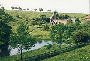
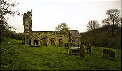
Wharram Percy is perhaps the best-known DMV in the whole of England, although there are several others which are in a similarly good state of preservation. The reason for its celebrity is that it was researched each summer by combined teams of archaeologists, historians and even botanists, from circa 1950 to 1990 following its identification in 1948 by Professor Maurice Beresford
Maurice Beresford
Maurice Warwick Beresford was an English economic historian and medieval archaeologist.-Academic career:...
of the University of Leeds
University of Leeds
The University of Leeds is a British Redbrick university located in the city of Leeds, West Yorkshire, England...
. It is mentioned in the 1086 Domesday Book
Domesday Book
Domesday Book , now held at The National Archives, Kew, Richmond upon Thames in South West London, is the record of the great survey of much of England and parts of Wales completed in 1086...
as Warran or Warron.
Although the site has apparently been settled since pre-historic times, the village seems to have been most active from the tenth to the twelfth centuries. The Black Death
Black Death
The Black Death was one of the most devastating pandemics in human history, peaking in Europe between 1348 and 1350. Of several competing theories, the dominant explanation for the Black Death is the plague theory, which attributes the outbreak to the bacterium Yersinia pestis. Thought to have...
of 1348–49 does not seem to have played a significant part in the desertion of Wharram Percy although the large fall in population in the country as a whole at that time must have made relocation to a less remote spot more likely. The villagers of Wharram Percy seem to have suffered instead from changes in prices and wages in the 15th century, which gave pastoral farming (particularly of sheep) an advantage over traditional cereal
Cereal
Cereals are grasses cultivated for the edible components of their grain , composed of the endosperm, germ, and bran...
farming. The village was finally abandoned in the early 16th century when the lord of the manor
Lord of the Manor
The Lordship of a Manor is recognised today in England and Wales as a form of property and one of three elements of a manor that may exist separately or be combined and may be held in moieties...
turned out the last few families and knocked down their homes to make room for extra sheep pasturage.
It is now in the care of English Heritage
English Heritage
English Heritage . is an executive non-departmental public body of the British Government sponsored by the Department for Culture, Media and Sport...
. Although only the ruined church is easily visible above ground, much more of the village layout can be seen in the surrounding fields. English Heritage has recently installed new panels around the site, as well as an audio tour downloadable, in MP3 format, from the English Heritage website. A guidebook is available from surrounding, manned, English Heritage sites.
A scientific study published in 2004 of human skeletal remains from the deserted village sheds light on disease, diet and death in a rural medieval community.
A Tracker Pack for families that covers the site can be hired from Malton Tourist Information Centre.
The Yorkshire Wolds Way
Yorkshire Wolds Way
The Yorkshire Wolds Way is a National Trail in Yorkshire, England. It runs 79 miles from Hessle to Filey, around the Yorkshire Wolds...
National Trail and the Centenary Way
Centenary Way
The Centenary Way is a route devised to celebrate the 100th anniversary of Yorkshire County Council.It was opened by Chris Brasher in 1989 to mark the Centenary of the governance by County Councils....
, long-distance footpaths
Long-distance trail
Long-distance trails are the longer recreational trails mainly through rural areas, used for non-motorised recreational travelling ....
passes to the east of the village.
External links
- Wharram Percy by the former chief guide of the Beresford excavation
- English Heritage - History of Wharram Percy
- Investigation history
- English Heritage's investigation of the site in 2002
- Lost Village Sites of Yorkshire: Wharram Percy
- Abandoned communities ..... Wharram Percy
- BBC Radio 4 programme on Wharram Percy