

West Virginia Prehistory
Encyclopedia
The Prehistory of West Virginia spans ancient times until the arrival of Europe
ans in early 17th century. Hunters ventured into West Virginia's mountain valleys making temporary camp villages since the Archaic period in the Americas. Many ancient human-made earthen mounds from various mound builder cultures survive, especially in the areas of Moundsville
, South Charleston
, and Romney
. The artifacts uncovered in these give evidence of a village society having a tribal trade system culture that practiced limited cold worked
copper
. As of 2009, over 12,500 archaeological sites have been documented in Virginia.
 The first evidence of humans in West Virginia dates back to the nomadic Paleo-Indians in 11,000 BCE. From 7000–1000 BCE archaic Indian cultures developed in the Northern Panhandle
, the Eastern Panhandle
, and the Kanawha River
Valley. They created temporary villages on the Kanawha region streams, Monongahela
and Potomac
tributaries streams of the Allegheny Mountains
. The early archaic people used atlatl
s.
Local cultural anthropologists abstracts having preliminary interpretation provide clues of the spread of cultural items, or trait
s of idea and material found in collective identities, as suspected exchange through inter-cultural middleman trade, migration, direct trade and intermarriage, enslavement after warfare or simply mutual absorption between the prehistoric peoples.
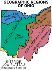
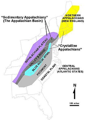 West Virginia is within the physiographic province
s of the unglaciated Allegheny Plateau
, which includes parts of the Allegheny Front
and Ridge-and-Valley Appalachians
. These western hills along the Ohio Valley climb east up tributary streams to the base of the Allegheny Mountains
. The lowest altitude averages 550 to 600 ft (167.6 to 182.9 m) above the sea, southwest bottoms along the Ohio River
(normal pool 538 feet (164 m)). Below the E slopes of the Allegheny Front
approximately 2600 to 4700 ft (792.5 to 1,432.6 m) peaks passing down the Potomac River
on the Eastern Panhandle of West Virginia
are similar land altitudes having relief of up to c. 2000 feet (609.6 m). The plateau
reach from the southeastern Ohio through western West Virginia easterly to the physiographic province, Ridge-and-Valley Appalachians, became dissected with a summit level ranging from about 1200 to 1800 ft (365.8 to 548.6 m).
In the west-central part of the state, the colder streams, with mountain trout, form the deeper warm water brooks and smaller river
s that feed the Ohio River, in the Plateau. The highest peaks today in the state are over 4800 feet (1,463 m). The Allegheny Mountains have no volcanic peaks and are rather quiet with very little and unnoticeable earth quake activity. The state mountains were formed by an Orogeny
effect of the North American Plate
. The Taconic Orogeny
near the end of Ordovician
time formed a much higher mountainous area in E West Virginia approximately 350 million to 300 million years ago in the Carboniferous
period. The plateau and mountains have a long history of erosion and throughout the region before peaking formation. The West Virginia Geological and Economic Survey in 2006, "These highlands formed the main source of sediments for the succeeding Silurian Period (ca. 443 million years ago) and part of the Devonian Period (c. 416 million years ago)." Devonian was about the time lobe-finned fish developed legs (Tiktaalik
) as they started to walk on land
as tetrapod
s. The Mesozoic Era (c. 250 to ca. 67 million years ago) of the Age of Dinosaurs is marked by Cretaceous–Tertiary extinction event and following Cenozoic Era with the dominant terrestrial vertebrates mammals from ca. 65.5 million years ago to the present— the Age of Mammals. Some of these ancient animal
evidence are found as fossil
between the geologic strata near the abundant sections of coal seams
and nearby natural gas
(fossil fuel
ranges) in the state.
The Quaternary
ice age (2.6 million BCE) began about the time of Pleistocene Epoch. The weather had been by far milder. Sitting snugly in the then much higher mountains was Glacial Teays Lake, extending from south Virginia through the New KanawhaRriver to its northerly drainage river, the ancient Teays River
. It flowed through Ohio
to central Indiana
across Illinois
to the Mississippi Valley. Lying on the north was the Pittsburgh drainage basin. The Mississippi River at the time was an embayment of the Gulf of Mexico
reaching to Illinois. Glacial Teays Lake last occurrence was about two million years ago when it outburst and the wash build up created the final large prehistoric lake in the western of the state. Lake Tight lasted only c. 6500 years before it outburst forming the Ohio Valley. The Ohio-Allegheny system (Ohio Valley) on the western half of the state was in its present form by the Middle Pleistocene
, ca. 781–126 thousand years ago. The remaining glacial lake in the northern area of the state was the glacial Monongahela Lake. It had been blocked by ice terraces or ice sheets in the north and western Pennsylvania. Upon ice retreat, it outburst through the basin to the north. It would reform with the next re-advancing glacial ice drift, ground rise and again, another late last occurrence with outwash build-up.
The last maximum extent (LGM
) of glaciation was approximately 18,000 years ago. This last returning advancement of glacial ice approaching the Ohio Valley began c. 30,000 years ago. West Virginia had no Ice Sheet buildup. Although during the Last Ice Age, smaller glaciation impounded lakes continued to collect precipitation on the plateau. These chilly lakes among mountain peaks were separated from the continental ice sheet to the north. The deeply carved river valleys like the upper Canaan Valley
to Blackwater Canyon
and the Dolly Sods Wilderness
to Cheat River
areas are called Paleozoic Plateaus. The "Driftless Area" drains into rivers having rugged regions of bluffs and valleys. According to the West Virginia Geological and Economic Survey, the two large Ice Age lakes varied throughout the epoch. The last glacial lake, Monongahela, occurrence in West Virginia "Carbon-14 dates of c. 22,000, 23,000, and 39,000 years old". It reached as far south as Weston
into the state. Monongahela lake redeveloped and overflowed perhaps at several places as its age is older than 780,000 years BP (WVGES 2005). The first ice-damming event was a pre-Illinoian (Stage) lake which outburst during the earlier ice retreat towards the northwest Pittsburgh drainage direction. The last occurrence of the Monongahela Lake an outwash gravel dam backed up slackwater at Allegheny-Monongahela confluence during an Illinoian ponding event last glacial retreat. The last outburst drained to its present coarse, the central Allegheny Mountains or northern tributaries of the state feeding the Monongahela River to the Ohio River.
The Cirque
and Tarn (lake)
were among heads of smaller outwashes through the Allegheny Plateau. Some of these backed waters cut through leaving higher flatland or terraces among ridge tops above the major river bottoms of which runoff sheds. Higher in the state is Cranberry Glades example lay between Mountain ridge top and peeks with five small, boreal
-type bog
s. These feed the mountain river, Cranberry River
, a trout
-holding biom. From these various mountain and hill formations, the Allegheny Plateau
has eroded and settled. In Pennsylvania the Titusville Till, results of very ancient Monongahela lake sediment, has an age of c. 40,000 years. There are several different strata of till layers across the region. Outflow of melt and weather contributed to the hill and mountain erosion. On top of the layers of geologic strata, settled drifts of kame or gravel shoals lay under soil sediments along the valley bottoms. "As one proceeds westward, the rocks are younger and younger," states Peter Lessing, July 1996, West Virginia Geological and Economic Survey. Below outcrops of the Paleozoic Plateaus are the largest kind of sediment by erosion, the large boulders peeking above the rivers surface. A variety of stone
of geology
for lithic tool making is found across the state in valleys (Brockman, US Forest Service, 2003). From these stone, artifacts are found providing evidence Paleo-Indians were passing through West Virginia. State universities and the U.S. Geological Survey Paleoanthropologists have found evidence of early Archaic people habitation during Holocene Climate Optimum—a rough interval of 9,000 to 5,000 years B.P.
to an evergreen forest, or taiga
, and eventually to a forests of oak, hemlock, rhododendron
, nut, berries, and Appalachian mixed mesophytic forests
. By 7800 BCE, the vegetation attracted modern game animals. Modern decididuous forests grew south and east of the Allegheny. Carbonized nut hulls from the St. Albans Site
(46Ka61) in Kanawha County date to 7000 BCE.
The New River (Kanawha River) flows from the Ridge and Valley Province
, and the head of the Tennessee River
, (Powell, Clinch
and Holston
Valleys) drain southwesterly the Ridge and Valley Province. The upper branches of the Big Sandy River
drains this province's northern slopes. While emptying near the mouth of the Ohio River
, the Tennessee River
and north Cumberland River
reaches from the west-draining Cumberland Plateau
opposite the Big Sandy watershed. The Tennessee River reaches easterly to the Ridge and Valley Province of the Great Smoky Mountains
, part of the Blue Ridge Mountains
which are a division of the larger Appalachian Mountain chain
. The Potomac River
, James River
and Dan River
basins drain the eastern slopes of these mountain ranges. Ancient mountain trails through eastern Kentucky
and West Virginia
allowed Native American passage between the northern Till Plains of Illinois
, Indiana
and Ohio
, otherwise a part of the Corn Belt
or Midwestern United States
and the Piedmont Plateau, and Atlantic Ocean
coastal plains. Trails through the region facilitated migration, trade, warface, and hunting.
Between 10,800 and 9500 BCE, the continental glaciers retreated north of the Great Lakes
. Glacial lake outburst flood
s occurred during the melt outflow. The Allegheny Mountains, which have no volcanic peaks, were was formed by an Orogeny
effect of the North American Plate
.
Flooding disturbed archaeological layers of lithics and ceramics in the alluvium of the south branch of the Potomac at the Romney
bridge replacement archaeological site. Early Lake Erie
, which were Lake Michigan
and Lake Erie
combined, flowed west out Little River (Great Black Swamp
proglacial lake's drainage embayment and the Wabash River
before changing direction to the east into Glacial Lake Iroquois
. Earlier sediments built up event outburst near the Little River more than once which altered the drainage direction and the remaining Great Black Swamp. 3000 years ago, Lake Michigan and Lake Erie assumed their present shapes. Lake Erie's water level was similar to Lake Nipioing phase of Lakes Michigan and Huron
basins 5,000 years BP. By 3500 years BP, the level had lowered by four meters and by 2000 BP the level had increased to possibly five meters above today's levels. Hopewell culture
arrived from the north in west central Ohio and Indiana by 2000 BP. Earlier trading peoples, also from the north, a vanguard Armstrong variant in southwest West Virginia mingled peacefully with Late Adena peoples. Cold-worked copper
from the pits in Wisconsin
Old Copper Complex
region have been found in some Adena mounds. The Upper Ohio Valley was experiencing the Sub-Atlantic climatic phase (3000-1750 BP) of warm and moist climatic conditions and stable stream levels upon the occurrence of the Hopewell culture
. This climatic phase began after the much earlier arise of indigenous Early Adena Culture
(46MR7, 1735 BCE) in West Virginia.
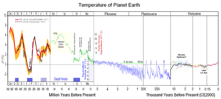 Paleoclimatology
is the study of prehistoric weather. The Eemian interglacial period spanned 130,000–114,000 BP. The Laurentide ice sheet
covered much of Canada and the northern United States from ca. 95,000 and ca. 20,000 years before present. The last advancement of glacial ice sheets in the eastern United States was the Wisconsin Glacial Episode, which caused the ice sheet to advance ended 10,000 years ago.
This freezing period temporarily stopped the ice sheets north of the Great Lakes
from thawing. It is called the Younger Dryas
Stadial, dating from 10,800–9500 BCE. Temperatures plunged 7 degrees and the sea level sank 100 feet below present level. Nomadic Paleo-Indian arrived in the upper Ohio Valley utilizing the Kanawha Black flint at this time. By ca. 9500 BCE the Younger Dryas suddenly ended and warmer temperatures returned.
The warm period during interval of 7000–3000 BCE is called the Holocene climatic optimum
and was a period of warm weather. Towards the end of the Archaic period, seasonal weather was a time of Meridional overturning circulation and large storms came up from the Gulf of Mexico
. The western and northern valleys of West Virginia became warm and dry with less effective precipitation around 2550 BCE, causing the bottom land flora to thin and creating an occasional major flood and serious erosion during the early part transitional weather pattern.
A period of drought was followed by a cool and wet Sub-Boreal climatic phase (4200–3000 BP), a warm and moist Sub-Atlantic climatic phase (3000-1750 BP), Scandic climatic phase (1750-1250 BP), a stable Neo-Atlantic climatic phase (1100-750 BP), and a cool and wet Pacific climatic phase (750 BP, Little Ice Age).
The prevailing weather pattern in the Middle Ohio Valley from 1350–1600 CE was cool and wet, followed by a period of frequent drought
s. In contrast, the upper Ohio Valley experienced milder weather patterns. The frequency of droughts in West Virginia increased in the following decades. Drought frequency during 1250-1400 CE is unknown. However, north of the Allegheny Plateau
, the Till Plains
was less effected by drought.
Two periods mark the rise and decline weather for true agriculture: the Medieval Warm Period
(800-1300 CE) and the Little Ice Age
Period (1400-1900 CE).
. The New Trout Cave in Pendleton County
has been studied by archaeologists since 1966 and is one of many Paleo-Indian cave shelters in the region. This ancient cave settlement is near the Lake Maumee. Among the Megafauna
of the region, a few American mastodon
teeth have been found on the broader river bottoms in western West Virginia. Wooly mammoths, mastodon
s, and caribou lived in the Kanawha Valley but died off or migrated north as the climate warmed.
Less than a dozen miles from the Northern Panhandle of West Virginia
is the Meadowcroft Rockshelter. Kanawha Chert from West Virginia was found at Meadowcroft Rockshelter (36WH297) Washington County, Pennsylvania. Kanawha Chert source is 183.4 miles (114 km) southwest of Meadowcroft (Vento and Donahue 1982:116). Quoting, "The lithic raw material data indicate the early inhabitants of Meadowcroft Rockshelter had been in the region long enough to discover local chert sources, but also utilized or exploited materials from a much larger territory than just the local region. Alternatively, the exotic lithic materials may indicate trade with neighboring groups, if they were present at that time." Paleo occupation has been dated from 11,320–14,225 BCE (radiocarbon date, Sciulli 1982:176). Paleo-Indian Clovis culture
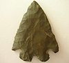
peoples left fluted Clovis Point
s in West Virginia. Plano cultures
(8000-7000 BCE) which followed Clovis knapped spear points lacking the groove or flute of the earlier Clovis Point. Plano peoples moved westward and hunted bison on the High Plains extending to Ohio and into the early Archaic time period. The Dalton Tradition
(8500-7900 BCE) represents another technical shift, characterized by a particular type of adz. The earliest stone point surface finds, like the Dalton
variants (8700–8200 BCE), are very rare.
Paleo-Indians lived in eastern North America by 6000 BCE, and by 4000 BCE had clearly differentiated into two groups: the southern archaic Isawnid (Indian Knoll culture of Kentucky) and the northern archaic Lenid (Great Lakes
Area) peoples
 The Archaic period, from 8000–2000 BCE, experienced warmer climates. Archaic peoples in West Virginia were hunter-gatherer
s, who fished and gathered wild berries, nuts, seeds, and wild plants. The megafauna had migrated or died out by this time, so people hunted deer, bear, wild turkeys, rabbits, and other small game with atlatl
s and small spears. The atlatls used stone elaborate weights called bannerstone
s. They used used ground-stone implements and flint
woodworking tools, as well as bowls of sandstone and soapstone, knives, and net sinkers. In Kanawha Valley, tools were made with Kanawha Black Flint. The Kessell Side Notched point at the St. Albans Site, dated to 7900 BCE, is an examples of a rare, early archaic stone point.
The archaic stone point chronology in the Kanawha Valley generally is as follows:
Some Brewerton Phase side and corner-notched points (side-notched tradition) are often found resharpened, and some were modified as hafted end-scrapers. A few uncommon Pointed Pole Adze
s are thought to have been used for heavy woodworking at one late northern Panhandle Archaic site (2000 BCE), where a dugout canoe has possibly been found.
The Red Ocher people and Glacial Kame Culture
s evolved together resulting in the following traits.
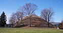
Sometime after 2000 BCE, people built large conical mounds with casks made of small logs at the base. Small conical gravel mounds quickly grew in size as Early Eastern Woodland people, known as the Adena moundbuilders
arrived from the east.
spanned 1000 BCE to 1000 CE. The Woodland period is differentiated from the Archaic Period by the emergence of agriculture, cord- or textile-marked pottery, and burial mounds.
 The Adena Culture
, which originated in Ohio, flourished from 1000–200 BCE in West Virginia. Adena people practiced agriculture and lived in settled villages. At its cultural zenith, Adena villages spread throughout the Midwestern United States
and were self-governing and loosely linked by trade.
Adena houses typically were conical structures, about 15–45 feet in diameter, and built around supporting poles, either single or double. Roofs were made of bark and walls could be wickerwork or bark.
Adena crops are part of the Eastern Agricultural Complex
. They grew squash, sunflower (Helianthus annuus), sumpweed, goosefoot, knotweed, and maygrass. Gourds were grown for containers and rattles. What might be a small bird pen found one Adena site suggests limited animal domestication, but Adena people are not known for animal husbandry.
Tobacco
was an important crop and was smoked in effigy pipes. Turtles, ducks, and other animals were represented in Adena art. Limited amount of copper was imported from the western Great Lakes region, and marine shells were imported from the Gulf of Mexico.
Adena nobles wore tanned heads of animals during their ceremonies. They wove coarse cloth, colored with natural dye
s. Red ochre was placed in elite graves. They altered their appearance with cranial deformation. Cordage was spun from sinew, hide, and fibrous plants.
During the last few centuries Adena zenith (500 BCE), however, a second horizon with political cohesion (Priest Cult) arrived in mass invasion above the Ohio River. Late Adena people fled south of the Ohio, joining their kindred. And, some continued to flee as far as the Chesapeake Bay
traditional trade area. A few fled towards the easterly Point Peninsula Woodland culture otherwise Eastern Great Lakes
trade area. Their mounds progressively become smaller through Virginia
. These soon assimilated with the regional Woodland People friends. The large conical Adena Turkey Creek Mound (46PU2) on the Great Kanawha dates to 886 CE.
 Adena mounds in West Virginia include:
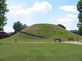
The Grave Creek Mound in Moundsville
is the largest mound in the state and was once surrounded by a moat
. Cresap Mound redefined what constitutes Early to Middle Adena culture
(1000 BCE), as opposed to Late Adena (500 BCE).
 The Mid-Atlantic region cultural pattern is found early in West Virginia. An Early Woodland people from the east began to trade with the latest Archaic people in the state. Early Woodland peoples established sites on floodplains, terraces, saddles, benches and hilltops. Storage or refuse pits in habitation sites appear. Analysis of a new style ceramic discovery from the Winfield Locks Site (46PU4) has provisional Early Woodland dates of 1500-400 BCE along the Kanawha shores. The earliest ceramics of the region's Woodland Culture (1000 BCE–1250 CE) is called the Half-Moon Ware. There are now two known types of early ceramics of the Woodland Culture. It has been suggested that oval or circular structures were used as houses. In 1986, Grantz attempted to test in Fayette County, Pennsylvania
several post mold arcs for a pattern to confirm the suggestion of early village houses. Fragile understood and earnest effort, it was not confirmed. The Middle (1-500 CE) and Late Woodland (500-1000 CE) Periods for the Northern Panhandle of West Virginia
will include the Mid-western cultures of primarily Adena and Late Hopewell (1-500 CE) from McConaughy (2000) research. "Nebulas" is a term to describe late Hopewellian—localizing societies. Later (650 CE), some Woodland will be along side very Late Adena (46PU2) and assimilating on the Greater Kanawhan region. Burial ceremonialism and mound construction gradually becomes smaller which is phased out by the end of the Woodland period. Because these phases lack funding and resources, more field work and studies are needed to get a clearer view of these cultures. However, because tobacco was probably being grown and used, McConaughy in 1990, suggests the development of complex society. Early Woodland peoples lived a more settled existence.
Fairchance Mound and Village of Marshall County, West Virginia
is a Middle Woodland complex. The mound artifacts carbon dates to the 3rd century CE One of the tombs in the mound is unique as being a stone lined crypt. This "crypt" was simply a layer of "slab-stone" covering the mound with more dirt placed over the "sheets" of stone. This was not what one would think as a "boxed-in crypt." This should not be confused with the centuries later Hadden Phase (1100–1600 CE) Hadden site (15To1) mortuaray complex (Allen 1977:14) stone box grave and stone slab-lined crematory cist of the Kentucky Western Coal Fields
Section. The Fairchance village pottery included Watson Ware that was lime stone tempered. The stone points were Fairchance-notched and Snyders points. The foods found through screening were the semi-domesticated "wild plants" listed in the summary below for this period. The nearby Watson Farm village dated between 1600 to 1400 BP and its small, one-yard high mound also contain a stone crypt. The limestone tempered Watson Ware along with a limited amount of grit tempered Mahoning Ware was found. Flotation samples were performed at this site, but, these have not been analyzed by botanical specialists. Either wild or domesticated Chenopodium
, goosefoot, was found. These Middle Woodland people subsisted primarily on wild plants, animals, fish, and shellfish. Each site had a single circular structure found, which may be due to limited excavation.
Maize horticulture appears in the Late Middle Woodland (550–950 CE) and seems to be an "economy" crop.McConaughy 2000, Dragoo 1956 "Climbing beans" similar to today's Kentucky Wonders planted beside hills of maize
(corn, Zea mays) appear in the Northern Panhandle and Monongahela drainage
system by the 14th century. This is after the northern West Virginia and western Pennsylvania "Hamlet Phase" of the Monongahela culture (Monongahela Drew "tradition", R L George et al. of Pa) which transitions to Fort Farmers (1200 CE) now located on higher creek flats and ridge line gaps. The grit tempered Mahoning Ware pottery becomes the primary ceramic form. Stone points, the Jack's Reef Corner Notched, Jack's Reef Pentagonal
, Kiski Notched and Levanna
, indicate that the "spear thrower", a common incorrect terminology for the atlatl and dart, was gradually gradually replaced by the bow-and-arrow during the Late Middle Woodland. Both atlatls earliest bows and arrows were used in West Virginia at about this time frame.
 Late Woodland peoples wigwam settlements increased in size within relatively fixed territories. Late Woodland temporary hunting rock shelters increased the distances to procure resources. Facing Monday Creek Rockshelter (33HO414) in Hocking County, Ohio
documents this resource expansion process. The value of knowledge sharing across borders today can be exampled by quoting one of several. In his 2006 abstract, Steven P. Howard sums up his field team's findings, "Elements of the Ohio Hopewell fluorescence are evident at the Caneadea (Allegheny County, New York
) and other northeastern mounds, but direct Hopewell influence appears to have been minimal. Data from northeastern mounds indicate that Hopewell may not be appropriate as a universal label for Middle Woodland mound building cultures."
State Archaelologist Dr. Robert F. Maslowski writes, "The Woodland (1000 BCE–1200 CE) on the Kanawha and Ohio Rivers settlement patterns at Winfield Lock Site and the Burning Spring Branch site (46KA142) have provided radiocarbon dates and good physical descriptions of the earliest pottery in southern West Virginia. This site is a multi-component site having several strata with a stockaded Fort Ancient Village (ca. 1500 CE) with 25 houses. West Virginia's Middle Woodland Period (650 CE) was redefined to include Adena with conical burial mounds. Gallipolis
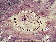
locks expansion project on the Ohio River for industrial navigation upgrading allowed the Kirk and Newman Mounds and an Adena ceremonial circle at the Niebert Site to be totally excavated. This provided for new interpretations of Adena ritual associated with burial mounds (Clay 1998, Clay and Niquette 1992). The paired post circle at Niebert consisted of outward sloping posts forming an open air structure. No artifacts were found in the structure but one large pit contained charcoal and fragments of cremated human bone. The structure was interpreted as a place where bodies were cremated and the remains reburied in local burial mounds like Kirk and Newman." (Maslowski 2003).
revealed that native Americans were burning forests to clear land as early as 100 BCE. Maize agriculture became more commonplace during the Middle Woodland 400 BCE–400 CE, which also saw a flowering of Eastern Agricultural Complex
, that is, the increased gardening of indigenous seed crops. Maize came from the southwest to the lower Mississippi Valley. Bean cultivation precedes maize in the upper Ohio Valley. The following Late Prehistoric Woodland people approached solving this problem with the development of the Three Sisters Crop method or companion seed Sowing
. As Dragoo explained, environment in geograghy effected development in ways of human living. Walton C. Galinat researched maize cultivation in the Eastern United States
. These studies include terrain altitude deviation (valley vs ridge flats and plateau frost days) daily temperature changes and number of days for the growing season comparing variety of maize through time. Early variety of maize needed considerably more growing days than eight-row maize to include considering soil conditions and changing weather patterns. In New England maize was well established by 1200 CE and distributions of the Southern Dent Pathway established other varieties of maize after 1500 CE. "Maize (corn) did not make a substantial contribution to the diet until after 1150 B.P." wrote Mills (OSU 2003).
Watson pottery making people lived along the upper Ohio Valley from the Kanawha regions through the Northern Panhandle and adjoining state border area who also extends into the Eastern Panhandle. Tobacco growing remains important among certain tribes, hunter gathering gardeners, hunter-fishery horticulturalist, and later hunter-fishery farmers of the region. Tobacco seed is extremely small and seldom found in screening results in abstracts. Tobacco is evidenced to the many pipes and its bowl's residue found at certain sites rather than the seed itself. The arrival of the tomato in the region is suspect to historic if not found earlier of proto-historic. Both the squashes and gourds long predate maize and beans in the state. The cereal maize surpassed the Woodland's cereals little barley and may grass though wild rye
, an overlooked Elymus (genus)
.
Watson people (100–800 CE) generally lived on flats above annual flooding of the major rivers nearby their small conical mounds. Their dominate pottery preference was decorated with a Z-twist cordage technique
(Peterson 1996:95; Maslowski 1984a). This period signals an ending of large conical mounds northerly in and along the state. Here they arose adjacent the Armstrong people and following Buck Garden on their south extent. The spanning duration and region Woodland type site is Watson 46HK34 (Woodland/Watson) located at Hancock County
. Upon their horizon and zenith, there were no bean or maize seeds in the state. These were hunters and fishermen, but gardeners of a larger variety of indigenous seed crops who were transitioning to just supplemental of gathering wild berries and nuts. The bean of the horticulturalists appeared sparsely in the area toward the ending of this period. About the time the Buck Garden arise, they are also found living in small compact villages. Their mounds were made partly with rocks having more people buried within than earlier special person mounds before them. Bow and arrow people follow the Watson People into the Northern Panhandle area and on the upper tributaries of the Monongahela River
. Watson Pottery People would see the arrival of the arrowhead. Monongahelan pottery begins with a grit temper describe below in the Ceramic chapter. "The Watson sherds are of no ceramics of the Hopewellian Series", according to Prufer & McKenzie of Ohio and concurred by in state contemporary scholars.
Wood Phase was contemporaneous with Scioto Valley Tradition's earlier period of post-Hopewellian Cole Culture of central Ohio. Influence from the southeastern United States during late Cole period in Highland County, Ohio
is manifest at the Holmes mound (1135 CE). The earlier of the period, Voss mound (910 CE) example, was a ceremonial plaza. Cole houses of as many as six were orientated in a half circle facing an open plaza. These predate log palisaded villages. Nearly 100 miles southerly east of the Cole people on the Ohio Valley, the type site of Woods Phase on the Mouth of the Kanawha
, is exampled at Woods (46MS14) which has very little occurrences of maize as a staple food. These horticulturalists are of the greater Kanawhas region. Like the Watson before them, these camps are found above the flood terrace but with linear and dispersed household groups. Charles M. Niquette explains his associates finding (46MS103 ), "Niebert's circular structures are the first well documented Adena structures to be found apart from mound contexts in the Ohio Valley." Niebert Site (46MS103) yielded important evidence of use by Late Archaic, Middle Woodland (Adena) and Late Woodland peoples (CRAI). The Late Woodland component in Cabell County, 46CB42 Multi-component, was more similar to Woods and Niebert than to Childers. This component was more similar to people in the interior Southeast than to those in the mid-Ohio Valley of central Ohio and northern Kentucky (McBride & Smith 2009). Small sherds of Woods phase pottery can easily be mistaken for Parkline pottery (O’Malley 1992). Parkline phase people were also present in the region, however, there appears to be no intensively occupied sites. This period seems to be a peaceful trade era for the latest Woodland cultures of the region. The Fort Ancient hamlet and companion crop fields era, beginning with (46WD1) Blennerhassett Island Mansion (891-973 CE), differentiate the Late Woodland Wood Phase of the Eastern Agricultural Complex in west-central West Virginia.
Hopewell at Romney Mound on Tygart Valley appears to be a distinct variant. They occurred during the neighboring Watson through Buck Garden period to their south and westerly in the state. However, this very late Hopewellian arrival of a particular small conical mound religion' appears to be also waning to the daily living activities at these sites. This period begins a rapid fading away of influence by an elite priest cult
burial phase centered towards the Mid-west states. However evolved, they were existent to the occurrence of the earliest Monongahelan. This area is a portion of the greater Montane.
Montane (500-1000 CE) locations include the tributaries of the Potomac on the Eastern Panhandle region who also had an influence by the Armstrong Culture and Virginia Woodland people. Their traits are characterized as blurred. The Late Woodland Montane had a lesser degree of influence by Hopewellian trade coming from Ohio. Yet by Romney, similarly polished stone tools have been found among the Montane sites in the Tygart Valley
. Small groups of remnant Montane people appear to have lingered much beyond their classic defined period in parts of the most mountainous valleys of the state. What little is known of the Montane is from the early work of the Smithsonian. Their area is within the much less developed of the state, forest and parks, however requiring little immediate required field work. Albeit, New River has current required activity, 2010. Neighboring south the Incipient Intermountane (CE 800-1200) followed by the Full Mountane (1200~1625 CE) are found in the Ridge and Valley provence in western Virginia (Blue Ridge) and SW West Virginia border area to upper border area of W North Carolina.
Wilhelm culture (Late Middle Woodland, 1-500 CE) appeared in the Northern Panhandle. "An excavation in Brooke County
first drew attention to the distinctive practice of the Wilhelm people of building small mounds over individual stone-lined graves and then fusing several graves together into a single large mound", quoting Rice and Brown, West Virginia: a history, Edition: 2 - 1993 page 7. These had a Hopwellian influence (Rice & Brown 2nd ed. 1993:6). Although not as well made, their pottery compares with coexistent Armstrong pottery. Fragments of pipes appear to be platform type. These less studied rural environs of early small rock mound building requires more work. Monogahelan-like later arises next to the atlatl and dart using Wilhelm area. Any influence is presently unknown. However, Watson people were also in this area. South of the Northern Panhandle, the Woods Phase follow the Watson people.
Armstrong culture
(Woodland, 1-500 CE) practiced cremation and built small mounds central to the Big Sandy Valley. They are thought to be a variant of Hopewell, an influenced Middle Woodland from an earlier culture who peacefully mingled with the Adena mix, or an intrusive Hopewell-like trade culture or a vanguard of Hopewellian who probably peacefully absorbed some Adena through to the Great Kanawha Valley area. Here, this period is of the accretion by cremation or enlarging of the mounds. Their clay pottery has a glazed yellow-orange color as described within this article. Their villages appear to be scattered over a large area with small round houses. Their limited garden was compared to Adena. Small flaked knives and corner notched points were often flint ridge material. Sometimes called Vanport Chert, this material is from the greater Muskingum River
valley area cited in the later Stone Industry chapter. They slowly evolve into the Buck Garden people.
Buck Garden (500-1200 CE) were more so throughout central Kanawha-New River Valley region following the upper Armstrong. They were first identified at the Buck Garden Creek site in Nicholas Co. (Rice & Brown 2nd ed. 1993:7). Buck Garden people buried under Rock Mounds and cliffs. They lived in compact villages and began raising beans included within the Eastern Agricultural Complex
method or system. Many illustrations of living activities in print through the decades have been suggested. These ideas have ranged from bazaar to a probability. They grew or gathered seasonally root and ground vining foods, picked spring greens, berries and ramp followed by gathering shellfish up creek flats, hickory and walnuts. Use of spice and Sassafras
is presently speculative. With their fishing pike, they fished the spring run and in the following cooler leafless seasons they hunted game. Like their rock mound burial within the state's interior, their extent use of rocks is not clear and speculative— small fishing jetties and possible use of the curious game-herding stone walls. A few centuries before 1200 CE, they had migrated into the hillier areas of the state as the Fort Ancient Tradition and Monongahelan of the companion planting
system begin to arise in the middle and upper Ohio Valley tributaries. The classic Buck Garden culture was gone by 1250 CE. The Bluestone Phase and Monongahelan period had eclipsed the Buck Garden.
Childers Phase occupation at multiple strata Parkline Site (46PU99), Putnam County, West Virginia
, is most likely associated with populations living in the Scioto Valley
of Ohio
of early Late Woodland, around 400 CE (CRAI 2009). This has compact cluster of thermal features and storage or refuse pits. Houses are not identified, although broadly, Woodland houses are generically described as small wigwam
. At the Winfield Locks Site (46PU4) possible oval structures were suggested. Like the Parkline, this reflect cultural intrusions into the lower Kanawha Valley by small, highly mobile groups.
Parkline phase (750~1000 CE), intrusive Late Woodland, appearance on the Kanawha Valley
is found at site 46PU99 (1170-1290 CE), a multi-component site in Putnam county
. It is represented by numerous thermal features, including large, rock-filled earth ovens on the Kanawha Valley having its origination from the northeast Atlantic Seaboard dating to 900 CE. Their decorative pottery attributes are grit tempered pottery with folded rim strips, cordwrapped paddle edge impressions placed on vessel collars and lip notching and/or cord wrapped dowel impressions. Parkline phase "are thought to be inhabited for very brief periods of time by highly mobile, nuclear family groups." Corn was not a major subsistence. They are also thought to be frequent visitors to the Woods phase site (46MS14) as some sherds are found similar. Parkline phase's region extends up the Ohio River from Louisville, Kentucky
to Point Pleasant, West Virginia
, and along the Ohio's major tributaries as defined here. No Parkline phase sites with intensive human occupation have been found in West Virginia.
Anthropologist Anna Hayden writes, "However, somewhere in the Middle Woodland (ca. 400 BCE–900 CE), these large-scale trading systems seem to collapse, ending the cultural continuity that had existed for some time (Custer 1994)." Algonquian speakers from the Great Lakes
region likely began migrating into the Middle Atlantic region around 100 or 200 CE. Their dominate pottery preference was decorated with a S-twist cordage technique. As many as six peoples shared a short period of transitioning in West Virginia. The earliest hamlet village farmers of Fort Ancient and Monongahela were concurrent with the latest Wood, Parkline, Montane and Buck Garden peoples for relatively short passage of time to a new way of living in the state using shell tempered pottery with variational pottery decorations and bow with arrows.
Excavated sites are surrounded by other unstudied sites, believed to traveling hunter's camps. A hunter's camp near 13 Mile Creek, with the Panther Petroglyph (46Ms81) is not assigned to a phase.
region of the lower Chesapeake Bay
. These people generally lived in smaller encampments as they fished and clammed. A few storage pits have been identified (Potter 1994). They had limited gardening, as recent findings suggest they included the sunflower
which predates the large-scale Mesoamerican influence to the Carolinas and Virginia.
Mason Island culture, an agricultural village complex, pottery is a newly defined pottery type now being called Page Plain along with a few sherds of Page Cord-marked ware in very limited numbers compared to the limestone-temper. Although a little too early in the state to be called as such, a precursor Levanna Triangle
tipped their arrows. Mason Island Phase sites are also referred to as Page Phase as sometimes known in west Maryland
. This should not be confused with the Page Phase (900-1100 CE), a western Kentucky primarily mortuary complex at Page site at Logan County, Kentucky
of the Mississippian Culture
. The Mason Island's Page Phase is one of three Late Woodland cultural subdivisions known in the Monocacy River
area just before European contact W from Alleghany county
. It is not Mississippian. Dr Maslowski (2009), "The New River Drainage and upper Potomac (Potomac Highlands) represents the range of the Huffman Phase (Page pottery) hunting and gathering area or when it is found in small amounts on village sites, trade ware or Page women being assimilated into another village (tribe)." They had occupied the upper Potomac to the northern, otherwise, lower Shenandoah Valley region before arrival of Luray Phase people in 1300 CE. Mason Island people were pushed to the west Piedmont as about this time the Potomac Creek complex appeared in the coastal plain of the Potomac River.
Luray Phase, are characterized by shell-tempered Keyser Cord-marked pottery; small, isosceles Madison points and palisaded, agricultural villages. These pushed out the Mason Island complex central Potomac Valley by 1300 CE to the neighboring areas including up the Eastern Panhandle
rivers of the Montaine Culture people and New River drainage neighbors of Bluestone Phase (Jones 1987). Luray Phase were of an Algonquian
dialect (Potter, 1994). Neighboring in Maryland, the Luray Complex dates to 1250–1450 CE. The youngest within the Maryland Accokeek Creek site (1300–1650 CE) is associated with the historic Piscataway people.
Rappahannock Complex is of the Late Woodland of the Lower Potomac River
basin of 900~1700 CE. It is not clearly defined, although there are two temporal phases—Late Woodland I and Late Woodland II (Fitzthugh 1975:112) Generally, their pottery was shell-tempered and similar to Townsend Ware pottery. Earlier phase, these people increasingly utilized smoked oysters, stored them and increasingly traded them further in land. Temporary oyster gathering sites is suggestive that they also divided their seasons to agriculture (Potter, 1994). Townsend ceramics were considered to be trade items associated with the Potomac Creek complex trade coming from the Algonquian Delmarva Peninsula
(Custer, 1986) and Slaighter Creek Complex (Baker).
Montgomery complex (900~1450 CE), were a Late Woodland people on the Piedmont
Potomac Valley. They would take refuge to the James River by the middle of the 13th century with others from the greater Carolinas region. (Cissna 1986:29) They were similar to the Carolina Algonquians who had been living there (S lower lands) for a duration of nearly six hundred years (Outlaw 1990:85-91). There appears to be a coalescing with the late Potomac Creek complex evidenced by the building fortified villages along the Chesapeake Bay
and Piedmont plains. It is thought building of these "forts" was in defence from Iroquois language groups coming and going to the region.
Potomac Creek complex on the "Neck of the Potomac" valley may date as early as 1200 CE, although clearly by the late 14th century. Their house shape seemed to be rectangular with the one example having a round end. (Schmitt 1965:8) A longhouse was clearly defined at two different villages. (Stewart, 1988) Their obtuse-angle clay pipes are similar to those found on the various Delmarva Peninsula complexes coastal Maryland and Virginia, to northeast North Carolina
. (Custer 1984, Ubelaker 1974, Potter 1982, McCary & Barka 1977, Green 1984, Phelps 1983) Schmitt had earlier define this kind of pipe to this particular complex (Schmitt 1952:63 & 1965:23) and maintained this position in 1963. Another early Schmitt assigned supposed unique trait of the later Potomac Creek was the human style shell maskettes having the "weeping eye" motif (Potter, 1994). "Shell mask gorgets with weeping eye designs are commonly found in E Tennessee, northeast Arkansas, and the middle Ohio Valley on sites dating to the Protohistoric period or just prior to it, quoting David Pollack, Kentucky Heritage Council. Potomac Creek dates from 1300–1700 CE.
"It is a mistake to assume that these language families (Iroquoian and Algonquian) can be extended backwards in time unchanged for several or more millenia, or that the speakers of these languages remained unchanged and stationary in their original homelands.", Hart and Brumback, American Antiquity, 68(4), 2003. pp. 737–752, Society for American Archaeology.
styles. Self sufficient, normal trade was between neighboring hamlets. Commonly found at these small farming hamlets and later log palisaded villages are shell hoes, ceramic pipes, bone fishhooks, shell-tempered pottery, triangular arrow points, shell beads, and bone beads. Early and Middle Fort Ancients phases lived in their villages year round (Peregrine & Ember 2002:179), a common practice of others later in the state. Unseen in West Virginia, some houses in the central Ohio Valley will have mud daubed sides similar to Mississippian according to Peregrine and Ember publishing of 2002. Lynne P. Sullivan writes of Mississippian influenced east Tennessee
, "There is little evidence for interaction between Upper Cumberland people and Fort Ancient groups that lived along the Kentucky and Big Sandy rivers to the north and east. In fact, the Upper Cumberland region appears to mark the northern margin of the Mississippian "world" in this part of the southeast."
Monongahela-style stemmed stone pipes have been found among a few southeast Fort Ancient sites, including Orchard and Man, and Mount Carbon. Rafferty and Mann 2004:98 Although, there appears to be no Monongahelan Monyock Cord-impressed ceramic pipes at Fort Ancient sites. Shell-tempered pipes are probably not Iroquoian as found at the Clover site and one of the two fragments from the Buffalo site. A pipe found at the Hardin site near the Big Sandy has an etching of a lizard. These sites are in the southwest part of the state.
), George describes Drew pottery as like a "bean pot" or "more squat." Early Fort Ancient Tradition sedentary hamlet crops Roseberry Phase (Brose et al. 2001:70,85. CE 1050-1250) were adjoining southerly in the Little' and greater Kanawha region as were Feurt Phase (46WD35, 1028~1720 CE).
roots are of farm fields and hamlet with no palisading walls on the major broad river valleys following the late Watson people. The Worley village Complex (46Mg23), Monongalia County, West Virginia
, dates to about CE 900. To quote the Maryland Archaeological Conservation Lab, "Monongahela ceramics are a complex series that begin with an early grit or limestone tempered group and end with a very anomalous collection of types found in southwestern Pennsylvania during the post-Contact period." Their cannal coal pendants are found from the Great Kanawha through to just the southwest corner of Pennsylvania protohistoric Monongahelan. Now being pushed, their circular become palisaded villages move near ridge gaps. These villages were smaller and the artifacts are of a less variety than Fort Ancient. Houses were generally circular in shape often with nook or storage appendage. Late Monongahela (1580–1635 CE) sees a charnel house of a shaman burial at a few villages according to the Monongahela Chapter of the West Virginia Archaeological Society. Differing characteristics between Fort Ancient and interior Monongahelan of West Virginia, "A reflection of the Monongahela's greater Woodland heritage was the continued use of small stone mounds in the Monongahela drainage area, well into the Late Prehistoric." A furthering difference of their palisaded village were bastions or shooter's platforms and a maze-like entrance sometimes covered. Late Monongahelan were likely middlemen in a marine shell trade network extending from the Chesapeake Bay
to Ontario (MCWVAS 2010). In 2005, the Haudenosaunee repatraited soil and associated funerary objects from the Fort Hill Site (46Mg12), which they reinterred on their tribal land.
In a 1978 abstract comparing McFate Artifacts at the McJunkin site with Johnston and Squirrel Hill sites in western Pennsylvania, Richard L. George reviews, "It was suggested that the McFate presence on the McJunkin site may have been the result of foreign potters, namely women, living among the resident Monongahela... and suggest a major population movement from the north in the 16th century and an amalgamation of peoples speaking dissimilar languages." During this century Stadacona
and Hochelaga
(Jacques Cartier
1535–1536) had disappeared, and the tribes along the shores of the St. Lawrence were no longer those of Huron-Iroquois stock, but Algonquian (Journ, 183-84; Clev. ed XXXVIII, 181). To quote Richard L. George of the Pennsylvania Archaeology Society, "I believe that some of the Monongahela were of Algonquin origin... Other scholars have suggested that Iroquoian speakers were interacting with Late Monongahela people, and additional evidence is presented to confirm this. I conclude that the archaeologically conceived term, Monongahela, likely encompasses speakers of several languages, including Siouan."
and geomorphology
.
Blennerhassett Phase of the Fort Ancient Tradition appears by 1250 CE. These people extend from the Mouth of the Little Kanawha area and began a few centuries before the Orchard people appear. They no longer utilized small burial mounds. The graves are now found amongst the houses surrounding the central plaza. Houses tended to be rectangular with round corners or oval in shape and were semi-subterranean with compacted floors. These people would become adept in palisading their circular villages with logs. This period shows a marked increase in maize diet than the earlier domesticated grasses or cereals of the preceding hamlet farmer. They continued to hunt small mammals, birds, fish, mollusks, elk, and white-tail deer. They follow the Roseberry Phase (Brose et al. 2001:70,85. CE 1050-1250) also northly from the Great Kanawha.
Feurt Phase (46WD35, 1028~1720 CE) ranges along the Ohio Valley from the Little Kanawha River down both shores and environs to the Guyandotte River and from here their area reaches across the Ohio River to the lower Scioto River in Ohio. Hobson Site 33Ms-2 (1100~1200 CE) is of Fort Ancient Tradition. The most diagnostic type of pottery found (plain, shell tempered rim sherds with punctate and incised decoration, with thick, crude, often punctate strap handles with castellations or raised rim areas), quoting James L. Murphy, "the material… seems to fit best the known characteristics of the type Feurt Plain." The major occupation is considered to fall rather early in the Feurt Phase. A radiocarbon date of 1350 CE has been reported. The Gue Farm site (46CB4) (1488, 1609, 1611) is a Feurt phase site (Maslowski 1984:152) and is two counties away from the Hobson Site. The Roseberry Farm site (46MS53) is another Feurt Phase (ca. 1046–1616 CE (CRAI)) people's location across the Ohio River from the Hobson Site and perhaps a half dozen miles away. Lewis Old Town site (46MS57) dates at 1398 CE, located near the Roseberry Farm site. Additionally Feurt locations are along the shores of the Ohio.
Bluestone Phase (Fort Ancient Tradition, highland farmers) is of Southern West Virginia
eastern-most Cumberland
(La Posta Volume 38 No 2 variously, Waseoto, Osioto, Osiata, Oseoto, and Onosiota) and south Allegheny
valley's watershed. These sites are of the New River (Bluestone
and Greenbrier
valleys) Fort Ancient Tradition component called, Bluestone spanning dates from 1028–1463 CE/ Jones studied 46SU3 (Barker's Bottom, 11-15th centuries CE, 46SU22 (blank, 1431, 1421); 46MC1 (Snidow,11th–14th centuries), 46SU9 (Island Creek, dated 1302 and 1286 CE). The area ranges from Summers
through McDowell
Counties into the adjoining southwest Virginia tributaries of the upper New River system.
(46CB40). Clover Phase is divided into two phases, Early Clover dating 1450—1550 CE and Clover dates of 1550—1640 CE. It shares the Great Kanawha area with a couple of late Feurt villages. The Clover Complex spans Putnam, Mason and Cabell counties along the lower Great Kanawha and Ohio rivers overlapping a central area of the older Feurt Phase. The Clover Site (46CB40) is one of the most important sites found in the Kanawha Navigation Project. Clover Site (46CB40), Buffalo (46PU31) and Rolf Lee (46Ms51) are suspected to be the same population rotating to each location upon resource depletion, firewood and soil (Maslowski). All three Fort Ancient sites have multiple village occupations and within a day's canoe or hike from each other. These houses for each occupational period clearly surrounded a centralized plaza within the stockaded village rather than in clusters within the stockaded village. Rolf Lee (46Ms51) last occupational period, found was 26 Marine
Shell gorget
s. This very late introduction is either as trophy of raid, through trade or migration of Southeast people. (photos ) This uncommon large amount of Citico shell occurrence was contemporaneous with the Orchard site of perhaps a dozen miles above them. Quoting Dr. Maslowski, "Besides the characteristic lithics and pottery, Clover has well preserved burials, bone artifacts in all stages of production and shell artifacts. It is one of the Protohistoric villages that may eventually be connected with historic Indian tribes."
in later publication, 1992 page 53, writes, "Fort Ancient is a construct of archaeologists conceived in error, perpetuated by conceptual rigidity, and misinterpreted by some serious and imagininative archaeologists." Myra Jayne Giesen (OSU 1992), "Generally, Fort Ancient phases are thought to reflect geograghic differences rather than temporal defferences (Essenpreis 1978; Griffin 1978)." Adjoining the Feurt Phase on the Hocking Valley, the Baldwin Phase, Joseph E. Wakeman writes concerning late 19th century and early 20th century archaeology then concentrating primarily on ceramic (and point) studies, "Hocking Valley communities of the LP [Late Prehistoric] period may be better described without the baggage that the term Fort Ancient carries. These communities should be viewed as a tribal, agriculturally based, nucleated, permanent settlements that demonstrate variability in their material culture (even the ceramics) within the boundaries of a watershed" (Wakeman 2003:19). Like the Hocking Valley in adjoining Ohio opposite of Wood County of the Feurt Phase, the Ohio River tributary rivers have geographically similar canoe navigable feeder streams with branching watershed creek hollows. Western West Virginia and south-eastern Ohio share the physiograghic division called the 'unglaciated' Allegheny Plateau of steeper hills and cliffs than the glaciated Central Low Lands or the "Till Plains" (Wakeman:53; Brockman, US Forest Service, 2003). Seventy nine percent of Central Ohio Valley Fort Ancient Communities are found on the Terrace Bluff or Upland (Nass, 1988:Table 2) and forty eight percent of multicomponent sites are located on similar terrain (Nass, 1988:Table 1).
Some late prehistoric Eastern Woodland tribes were more to hunter or fishery phases practicing slash and burn Eastern Agricultural Complex
gardening method. Continuing from ancient indigenous people of the state, field space and time was given to tobacco growing through to early historic among certain tribes. Another group progressed to the more time consuming advanced companion crop fields method of gardening. Eventually tribal villages began relying heavily on maize to also feed their turkey flocks as Kanawha Fort Ancients practiced bird husbandry. A population of 50 to something over 100 people was common and some 175 or more villagers of the Monongahelan. The final decades saw village growth as mentioned. Not since the larger Adena mound villages, late prehistoric (950~1550 CE) villages were sparse across the greater region. A tribe would relocate to another old field within a several county territory along and crossing the saddles of the valley ways, bypassed or protected from distancing transits. This practice continued into the historic as, for example, Mingo Flats was well off the popular route south, The Seneca Trail. As with the few others remaining throughout the state, its village smoke would not be smelled along the raider's thoroughfare.
"The Fort Ancient tradition follows the Late Woodland period within the Ohio River Valley. Joining trees (DNA ANALYSIS) revealed that the Ohio Hopewell do not group with samples from Fort Ancient populations of the Ohio River Valley, but with samples from Glacial Kame, Adena or Norris Farms, possibly indicating some relationship between the groups. This in part could be due to small sample size and a low number of sites that have been amplified. More work within all of the Ohio River Valley cultures is needed to give a clearer picture to archaeologists, linguists and biological anthropologists alike." Lisa A. Mills, The Ohio State University
2003, preliminary DNA research.
Office of State Archaeology (2008). In 1877 at the Ash Cave site in the Hocking Hills, Ohio, dry organic remains of possible arrow shafts were recovered (Ohio Historical Society). Jack's Reef (notched) and the common Levanna projectile point
s are thought by many to represent the initial introduction of the bow and arrow to West Virginia. The first appearance of the arrow dates a little later, 600 CE, within the state.
The introduction of the bow and arrow for hunting appears in the greater region by 500 CE (OHS) and clearly at village sites into West Virginia by 800–900 CE. The arrow was found to come from the north to the northwest valleys and to the E Allegheny Mountains
slopes from the Piedmont Plateau
. The Jacks Reef
and Levanna
are true early arrow points within the state. Jack’s Reef Corner Notched (600~1200 CE, WVAS & WVCA) points are referred to as "Intrusive Mound" points (Justice 1987:218) as also generally confirmed at places of the state by the formal scholastic papers. There is evidence of the triangular point size in the mountainous regions progressively diminish in size from lower land's gradual evolutions (Oliver). Not only does the triangle point signal bow hunting in the state, it also sees a few examples of curious small stone walls on the ridge line flats of the SE region followed by the palisaded wood pole fort builder cultures in the northwest valleys.
Propagation of lithics was summarized by Dr. Oliver, NC Office of State Archaeology in 1999, "If a tradition of manufacture can be identified and substantiated by stratigraphic discoveries in a number of distinct locales, it is then possible to recognize that particular tradition of manufacture through time and across space. Intrusive technological traditions may also be recognized. Recognition of attributes common to a particular tradition allows the archaeologist to go beyond pigeon-holing and make more meaningful interpretations from these ancient pieces of stone."
Surface arrowhead hunting yields a wide variation of projectile points along the major trans-region thoroughfares in the state. The state has centuries of "picking-up" points from the time of settlement and now become rather scarce. These have been saved by long held local private, university, and other public owned displayed collections. Along the western routes of tributary streams, points made of material from SE Ohio and W Pennsylvania are some times surface found north from the Great Kanawha, similar at a few sites. Although, the more distant distinctive neighboring cultural phase points are considered rare finds in the state. The earlier concave base type, elongated Yadkin (Levanna, Hranicky 2002:173), dates 300 to 1300 CE (Ritchie 1961 revised 1971). The scientist, Dr. Coe, based the longer and narrower Caraway on the Keyauwee Town 1936 excavation in North Carolina (Coe 1964 Formative Cultures of the Carolina Piedmont). Both the long slinder Serrated Western Fort Ancient and slightly shorter slinder Caraway projectiles are considered rare in Appalachia
. Another very similar small, slender long triangle of Piedmont Plateau Late Woodland called the Uwharrie projectile point type also follows the larger elongated Yadkin and early large Levanna. The similar point, local southwest Altizer and some Feurt variants with hints of "ears" (Hamilton-like), also appear in central Ohio Valley and dates CE 1400 (Carmean 2009). These rare finds with edges flaring to the base along the Blue Ridge border areas also generally have concave bases or somewhat straight base. Not as more often found as dart points, the Hamilton is an occasion. The casual collector in the state can find the small acute isosceles triangle point with a concave base made of varying flint and chert. The small Clements isosceles triangle point having either straight or concave base is very similar in Virginia
and North Carolina
(Coe 1964). Also, the southern surface collector's small late protohistoric Hillsboro resembles the earlier WV small levanna , however spanning dates of 1200 to 1700 CE. A slightly larger triangle-like with no ears nor flaring leading edges to the base precedes the isosceles triangle Hillsboro and is called the Clarksville. Those of small acute isosceles triangle having either straight or concave base made of Kanawha Black flint and Hughes River flint are commonly found at Late Prehistoric villages in West Virginia and south western Virginia (Holland 1970:88). It is often simply called "a small Levanna" (WVAS).
Levanna and Yadkin points, rather than cruder flintknapping
, are made using antler percussion flaking (bifacial) and finalized with a pressure flaking technique. The latter technique is also used to resharpen earlier points as some have been found of some Madison types. Both antler and bone lithic making tools are also commonly found among prehistoric West Virginia sites.
Of a similar flaking technique, the lighter Caraway Triangular point dominates at which time the incised rattlesnake gorgets influence from northwest Tennessee and southwest Virginia are found in several burials of site 31SK15 (Davis and Ward 1989; Eastman 1996). Some Citico rattlesnake gorgets are also found late in the Clover Phase in West Virginia. Excavations at Site 31SK15 by Coastal Carolina Research, Inc. page 14, "New ceramic styles may reflect interaction with the chiefdoms of the Catawba, Pee Dee, or Wateree drainages to the south (Eastman 1996)." It is suggested the term Yadkin be used for south of the James River and the term Levanna used north of the James River valley.
Hamilton arrowheads range from south Allegheny Mountains
and south Appalachian Mountains
to Florida. The concave base Hamilton with dates spanning 1600-1000 BP is also called Uwharrie in its central region. Along the upper Ohio Valley, a similar type to Hamilton has a subtle concave sides with small Ears at the concave base apparently comes from the north Hocking River's Coshocton flint as surface finds and the type occasionally seen at certain Feurt villages (Murphy 33Ms-2 abstract 1968:4, p. 1–14). A similarly described as Kelli Carmean writes in 2009, "Sharp (1988:195) has described basal projections, or "ears," a variation also present on some Broaddus specimens...In northeastern Kentucky, Type 2 points are diagnostic of the Early Fort Ancient (1000-1200 CE); elsewhere this type lasts longer, and marks Early and early Middle Fort Ancient (1000-1300 CE) times." A similar shape is found along the Guyandotte River
area locally called an Altizer having no clear dates. These are varying triangle examples surface found in collections.
Madison has a more of a straight base dates 1100-200 BP. Originally named Mississippi Triangular Point in 1951, Edward G. Scully renamed it to the Madison point having advanced research. Variously temporal to region, Railey types 1 through 6 are trans-regional. Madison Railey 4,5,and 6 types appear as the simi-sedentary early fur trade hunters also through the Ohio Valley. Later numbered types begin the 16th century (Drooker & Cowan 2001) arriving in the state. These small triangles signal in the state the transitioning of Late Fort Ancient. Seasonal hunters camps and returning to growing seasonal towns quickly eclipse the sedentary farm culture period (Carmean 2009). Madison arrowheads range the complete Mississippi
drainage and Gulf Coast
through to along most of the Atlantic Coast (Justice 1995). Both point types, elongated and the somewhat equal distant triangles of both dark flint and chert, are surface found across the state. The small Kanawha Black Flint Lavenna is predominate in central and northeast of the state.
Weather conditions 1350-1600 CE provided better for maize growing on the upper Ohio Valley and West Virginia's tributary valleys. At this time frame, the central and southwest Ohio (Till Plains) had cooler and wetter conditions effecting silking, polination and grain
filling stages that likely accounted for less yields. Corn consumption decreased in the middle Ohio valley (Staller, Tykot and Benz 2006:226,227). The following weather pattern had intermitant drought
s. This research also included isotope analysis
of samples from 47 archaeological sites in W and S Ohio, and W West Virginia (Staller, Tykot and Benz 2006:219,220). The scientists point out that samples from associated fauna
l remains would also be useful to obtain a clearer understanding. Donald and Greenlee, in 2005, hypothesized a combination of ecological conditions and pre-existing agricultural technologies could also explain the regional people's diet.
Hamlet and crop farmers who trade with the Chesapeake Bay
and the Gulf of Mexico
coincide with adaption of hunting bows in West Virginia. As a quick overview in scope, the early arrowhead called intrusive mound sniders point wanes. In a broad sense, a Hamilton point type appears along side other triangle types while the dart is still in use. At some Feurt sites a needle-like elongated triangle point appear along side large triangular points. A precursor to the Levanna
is the large type easterly of the state during early northerly Monongahelan and easterly Page pottery people areas. The Late Prehistoric people of the state would see the triangles reduce in size to true Lavanna arrow points. The following fort building farmers see early Madison types, smaller triangles, arrive toward the middle 14th century. Atlatl, smaller lance points and small knives extend into this period among some of the peoples. Other stemmed "bird points" can occasionally be found, but, not as often as the archaic stemmed and notched atlatl dart's point.
River boating also becomes significant during the atlatl
stone dart and arrow stone point arrival with some evidence of a coastal trade. Some hunters and warriors transitioned to bow and arrow. Although, the atlatl and dart continued use along side the arrow in the state into the Late Protohistoric. The main water way trade was the Ohio River
tributaries to the Tennessee River
system and the James
and Potomac
rivers to the Chesapeake Bay
. Although gigging from canoe is suspected, bow fishing is unknown. Eventually, not only localized trademen canoeing (Wakeman 2003:19), it is thought building of forts was in defence of raids on these productive people who lived in their villages year round as sedentary agrarian. Dr McMichael explained warfare can be assumed as some bodies with projectile point
s in them were found at the last occurrence of a culturally uncommon large palisaded Fort Ancient village at the Buffalo Site, 46PU31. Along with other local smaller groups of Fort Ancients, Rolfe Lee 46Ms123 village period #2 is suspected to have returned to Buffalo's last occupation. Traditional historians, Atkinson, Lewis and others within the state, declare Buffalo village was destroyed as a result of Fur Trade encroachment. Since then, a shell tempered pipe (Fort Ancient) and part of an Iroquois pipe is found in one of the 46PU31 occupational period artifact manifest to example briefly. Soon following transitioned is Late Clover phase and Orchard of mixed cultures now with much larger towns having no palisaded walls. Advanced hunting tools in hand and a changed emphases, these mix now seasonally break away from the town to winter camps up tributaries to gather fur for trade (Drooker 1997a:203; Drooker & Cowen, Transition of the Fort Ancient Cultures of the Central Ohio Valley, reprint 2001:83-106). The last occupation at Rolfe Lee 46Ms123 period #1 is suspected to be one of these un-palisaded towns during the dawn of local history.
Hunting parties left their towns after the growing season moving up tributary streams to temporary camps through the winter in the state (Maslowski 2010; Drooker and Cowan 2001). Local legends characterized the hunt having a religious respect.). The Riparian zone
on the lower western drainage, Allegheny Mountains
, have some creek bottoms which were covered over with shallow beaver lakes. At the base of these hills is the mantel created by watering animals at the edge of the beaver lake. The narrower bottom creeks become brooks flowing around cliff ridge-lines and rolling hills on enveloped terraces feeding the bottomland of major rivers. Along the bottom land and terrace of slower moving waters the Late Prehistoric farming Indian had lived and canoed. Occasionally, an earlier hunter's point from antiquity can be found around these mantels of which are distant across plowable bottoms from today's dryer creek beds. With an exception of elk
and mountain lion missing today in the state, these bowmen hunted today's game
.
In summary, the triangular Lavanna fades away across the greater region perhaps a century before Europe contact as more variations of the Madison Triangle (Railey type #4, #5, & #6) progresses. However this the case in general across the Northeastern United States
and the developed Old South
, this does not mean the production of point type stops at certain locations where less amount of urban archaeology work is conducted today.
s using color and texture as the principal criteria. Officials and scientists from the Midwest to included Missouri
, Indiana
, Alabama
, Kentucky
, Ohio
, West Virginia, Pennsylvania
, Tennessee
and Virginia
, working together in workshops, are now using Neutron Activation Analysis
, Macroscopic
, microscopic
, and geochemical identification techniques to help identify regional chert
s and chert sources. Rarely seen in the mountain valleys of West Virginia, Indiana, to date, has 23 distinct chert types which is considerably more of variation than West Virginia. Documentation in a large-scale data set from Kirk horizons at Indiana's Farnsley Site (12Hr520) near Louisville, Kentucky
, the Muldraugh chert and Wyandotte chert, among minor representations of exotic and other local or semilocal types, have suggested a pattern of more routine movement of Archaic Kirk towards the south and east. Representative examples included of lithics from West Virginia are Kanawha Black Flint, Hillsdale/Greenbrier, Helderberg, Hughes River among Flint Ridge, Carter Cave, Paoli, Knox, rhyolite, and ferruginous sandstone that were brought in from surrounding states (CWVA).
Towards the northly half of the state, common projectile points are from Flint Ridge, Ohio, Kanawha Black flint Mount Carbon outcrops, Hughes River
Flint, and Goose Creek outcrop in Ritchie County
according to Mr Cox, The Ritchie Gazette, 1979. Historian, Captain William A. Cox, Jr. described the Hughes River Flint outcrop as "twelve to fifteen feet thick, where best developed. . . The color varies from light, almost milky white, to buff, to grayish black." Kanawha Black flint ranges from Gauley Mountain near Kanawha Falls
through down stream tributaries to Charlestown. In the Bluestone Lake
area, woodland projectiles of red chert came from Mid-Atlantic states
or The Carolinas
outcrops.
It is legal to dig for "arrow heads" on one's own private property. However, for any suspected human bone find, one must stop digging and report the questionable bone to the county sheriff in West Virginia. This lawful department will notify the appropriate people for you. For hobbyist considerations, recorded details and location photos of the find increases value if not to the scientific community. The Council for West Virginia Archaeology (CWVA) and the West Virginia Archeology Society (WVAS) offers a list of resources to both formal school and "club" educators. They promote the understanding of our prehistoric heritage. "Since ours is only part of a larger regional picture", CWVA and WVAS have selected some credible Internet resources. Their link can be found in the reference section below.
 Upper Ohio Valley Lithic Sources
(Mayer-Oakes, Carnegy Museum
)
Bedrock chert along the both sides of the Upper Ohio Valley to the Big Sandy River
's lower stream region is called:
Bedrock chert from counties surrounding Pittsburgh, Pennsylvania
include:
Stream cobble cherts of north eastern Ohio
and western most Pennsylvania
along Lake Erie
(Alluvial cherts) include:
Exotic to Upper Ohio Valley types include:
art pictured or Petroglyphs. Most are on Homocline
out-crops and boulder
s overlooking stream valleys or are engrave
d on creek bed boulder's sides and some top-side, a variety. Below the mouth of Paint creek was a large "flat sided" stone embedded in the river the early settlers called the "picture rock" with many animals and a person engraved on it. Stone cutters used it for 19th century foundation construction. Another reported stream-bed stone, twenty miles above Charleston
, had a notable large fish engraved of which stone received a similar fate as "picture rock". Near the mouth of Campbell's creek a large stream-bed stone with Petroglyphs was cut for making a hearth, it is recorded. A portion of this "picture rock" still remains.
Many petroglyph boulders were quarried and removed for construction purposes in the state. In 1836, Alfred Beckley made a drawing and measured an enclosed stone wall with entrances, on Big Beaver Creek near Beckley
at the town of Blue Jay
, 46RG1. Large trees grew from the semi-enclosed walls, which was described as a "fort" wall or an early Spanish prospector's encampment. Mr Beckley's report was published by Craig's "Olden Times" magazine which was in circulation from 1838-1840 at Pittsburgh
. The Blue Jay Lumber Company was reported to have used the stone for an office building that still stands. There are also reports of Native American creating stone fishing weirds in creeks to easy gigging.
Below the mouth of Loup Creek was a salt spring and was a noted buffalo lick. On the overlooking ridge are remains of a stone wall with gaps running along the ridgeline. Around these gaps great quantities of elk, deer, bear and other bones were and are still found today. The 19th century Dr. Thomas S. Buster, a some five decades resident of Fayette County
then, wrote of the ancient wall lying immediately above Armstrong's Creek, Mount Carbon Stone Walls Site (46-Fa-1).
He describes it about one hundred yards from the top of the mountain to Loup Creek, near the Big Falls, "When I first saw it, fifty-eight years ago, it was in a much better state of preservation than it now is. At that time a large portion of it was standing fully six or seven feet high, and was well built. Its thickness was about two feet at the base, and slightly tapered towards the top. There were a number of gates, or openings, in the wall, that are quite perceptible even at this time. They were, however, very plainly perceivable a half century ago. From the number of stones promiscuously scattered in the vicinity of the wall, my impression is that it was originally greater than seven or even eight feet in height." This wall was nearly three and a-half miles long. Some have suspected it was nearly 10 miles long connected and having short branching elements also connected. Parts of some examples of these walls have been damaged during the 20th century. Immediately above the mouth of Paint creek on the Kanawha River
, a similar stone wall was nearly five feet wide at some locations. This example was only about a-half mile in length, but had higher walls of nearly ten feet high. A long held theory has watering and salt licking animals driven to the wall's gaps where waiting hunters had an advantage over the "herded" game. On bottom land near Mount Carbon
, excavations of the 1961-1962 dated back to about the 6th century CE and other dates to the 16th century Fort Ancient occupation. The nearby Robson
Mound was reported to be a stone and earthen mound of about fifty five feet high before fortune hunters reduced it to a couple of feet long before modern science arrived. The nearby Dempsey Mound in Fayette County
, along Laurel Creek, also was reduced before modern science arrived. Beards Fork Petroglyphs are a few miles away. The site at Alloy
in Fayette County, 46FA189, is a Woodland occupation site.
From the state's Native American oratory an interpretation of these sites is suggested. The watershed springs near flint outcrops having archaeological sites are interpreted as having spiritual significance being portals to other spiritual dimensions like the Underworld (Gage 2009:IV.). The outcrops were interpreted as the place of the “Flint Spirit.” The spirits of Native American travelers on the river and the spirit of the river also held a religious significance. Collectively of stone walls and rock piles or cairns near archaeological sites, "the evidence begins to suggest these sites are part of a regional phenomenon", Gage 2009:V. The locations include: Paint Creek Stone Wall, Rush Creek Wall, Raleigh County WV Wall Site (Unverified), Omar, Logan County, WV (Unverified), and other more stone cairns throughout the Kanawha Region (Inghram, Olafson, & McMichael, 1961).
The earliest ceramics of the region's Woodland Culture is called the Half-Moon Ware. Studies of late at Winfield Locks Site (46PU4), Half-Moon Cordmarked variant is a new provisional Early Woodland (1500-400 BC) ceramic series (Niquette and all). Jonathan P. Kerr writes, "Traditionally, archeologists distinguish the Woodland period from the preceding Archaic by the appearance of cord-marked or fabric-marked pottery, the construction of burial mounds and other earthworks and the rudimentary practice of agriculture (Willey 1966:267)."
Johnson Plain and Levissa Cordmarked are Early Middle Woodland ware from the Adena Phase of the Scioto Tradition in Ohio. These are similar to Peters ceramics and considered ancestors of the Middle Woodland wares of the Scioto Tradition from certain Ohio Adena sites. Two variants of the Adena ceramics in the Ohio Valley are the Fayette Thick and Adena Plain.
Watson pottery appears during the end of the Middle Woodland period, 100–800 CE. Exterior surface finishes are either cord-marked, plain, and rarily decorated incised towards the eastern area. It is often more to smoothed surface. This type of ceramic post-dates Classic Adena occupations on the upper Ohio River Valley. Watson immediately precedes the Page ceramic components in West Virginia. Watson ceramics are also found on the upper reaches of the Potomac River Valley in western most Maryland
, West Virginia
, ranging to eastern Ohio
and western Pennsylvania
, otherwise over a large area in the upper Ohio River
Valley. (Type Site, Watson 46HK34, Maryland sites with Watson components Mexico Farms (18AG167) ref. Dragoo 1956; Mayer-Oakes 1955; Wall 1993a, 1993b) Radiocarbon date; Adell, West Virginia (46GT67) Radiocarbon Dates 1270 + 60; 625-980 CE; intercepts from ca. 720–760 CE, Sample #Beta-51491 Wall 1993a. Radiocarbon date; Mexico Farms (18AG167) Radiocarbon Dates 1620±170; ca. 50–710 CE, intercept at 420 CE, Sample #Beta-42753, Feature 1a, Wall 1993a, 1993b. The Watson sherds are of no ceramics of the Hopewellian Series (Prufer & McKenzie, The Ohio Journal of Science 66(3): 246, May, 1966).
Mahoning Plain and Cordmarked Pottery(Mayer-Oakes’ 1955:192-195) type description includes three main types that date to the Middle-Late Woodland: Mahoning cordmarked, Mahoning plain, and Mahoning incised (MacDonald 2000b). A coil method, using crushed igneous rock
(e.g., granite
) or quartz
temper are called Monongahela cordmarked and Mahoning incised. Mahoning incised is more common on the Ohio Valley. Mahoning cordmarked decoration was crafted on the lip area. It may also be notched or impressed. A few sherd
s have shown evidence of fabric
impressions. The rim is slightly flared and sometimes found folded. Decoration is confined along the rim to the necks . Mahoning ware "seems to occur on sites which are Middle Woodland or Hopewellian" (Mayer-Oakes 1955:193).
Armstrong focus (1–500 CE) leading characteristics are being thin and tempered with particles of clay similar in color to the Peters ceramics, an oxidized color. They can have simi-pointed or flat bottoms and are generally large (Michael 1968:26); see Peters Cordmarked and Peters Plain.
Buck Garden focus (500–1200 CE), crushed rock of flint or sandstone tempered; cord marked and occasional paddle edge decorations. It is similar to Armstrong with less variation in shape and size.
Page pottery dates from 900–1450 CE western Piedmont Plateau region and west through the Great Valley, Ridge and Valley, and Appalachian Plateau
regions of Maryland, Virginia, West Virginia, and Pennsylvania. Page Cord-marked ware has limestone-temper material. Somerset phase ceramics are similar to Page ceramics of the upper Potomac River Valley. Somerset ceramics Type Site is based on the Pennsylvania Keyser Farm site (44PA1). Maryland sites with Page components include Nolands Ferry (18FR17)*, Mason Island (18MO13)*, Cresaptown (18AG119), Barton (18AG3), Sang Run (918GA22)*, Friendsville (18GA23)* (* collections at MAC Lab). The distribution of diagnostic Page Cordmarked Rims center of distribution is in the Huffman Phase on the James River
drainage of and westerly of the Blue Ridge Mountains
, otherwise, from the eastern slopes of the Allegheny Mountains
through central Virginia
, "diagnostic distribution".
Drew pottery (900~1350 CE) has a high percentage of plane ware and some with unique neck decorations. The latter has "parallel trailed elements as well as multiple motifs of lip appendages," according Richard George. This pottery's characteristics are slightly rounded bottoms rather than the tear-drop shape. The late Dr. Richard L. George, Society for Pennsylvania Archaeology, liken this pottery shape to a "bean pot." Drew is of an earlier phase of Monongahelan of northern West Virginia and south western Pennsylvania area. As suggested earlier by George, ongoing research projects evidence of Drew is increasingly seen as a separate culture (Johnson & Speedy 2009).
Monongahela Cordmarked, Plain, and Incised pottery is found to be tempered with crushed shell
. They used a coiling technique with malleation, tapping, by paddle and anvil. A cord-wrapped paddle was made to create the Cordmarkings. Interiors are smoothed and are plain or cordmarked with some smoothing. Decorations are found near the lip and adjacent lower rim. Monongahela Incised has the addition of incised parallel or rectilinear lines. The Worley village Complex (46Mg23) dates to about 900 CE (WVAS). Monongahela ceramics begin with an early grit or limestone tempered group.
Feurt-incised pottery (begins around 1100 CE) of the Fort Ancient Tradition appear along today's Ohio and West Virginia state bordering shores using shell tempering with its decorated incised oblique lines. It ranges from the lower Scioto
and Guyandotte
rivers and upstream to the lower Muskingum
and Little Kanawha
rivers area central to the 'Mouth of the Great Kanawha River
' greater area.
Cordage Twist impressed pottery decoration is found at Monongahelan and Fort Ancient sites of both shell tempered pottery and some limestone tempered. Middle and Late Woodland coradge twist in the state is among several more other earlier pottery finish types and more north-westerly S-twist cordage. Higher amounts of Z-twist is found at 7 sites in the W central of the state, or about half the amount increasingly to follow. By the Late Prehistoric and Protohistoric, the Z-Twist shows more predominant on the Peterson map 5.1 in the southern half West Virginia 14 sites with 70-100% and remaining 0-30% S-Twist Cordage. Gnagey village (southwest Pennsylvania, 36SO55 1000-1100 CE Monongahela, limestone) has 98% z-Twist (196 items) and 2% s-Twist (4 items), (George 1983:29). At the mouth of the Great Kanawha, the Lewis Farm site (46Ms57, 1300 CE, Feurt, shell) was excavated and had only Z-twist Cordage. These Z- and S-twist cordage methods date from 1000~1640 CE, ending with Rolfe Lee #1, 46Ms51 Clover, shell 87.7 Z-twist, 7% S-Twist (remainder non-in situ) and Rolfe Lee #2 46Ms123 Clover, shell 92% Z-Twist and 8% S-Twist (Maslowski 1984b).
The direction of the cord spin twist wrapped on the paddle is either S, left to right, or Z, right to left. The type appears in E Virginia earlier (mix of twist pre-200 CE), and through to Vermont
(Haviland and Power 1994:121) after the end of the Middle Woodland period about CE 800 (Johnson and Speedy 1992, Petersen 1996:148). During the Sponemann phase (750-800 CE), Sponemann Site is the type site for non-American Bottom migrants making a high amount of Z-Twist pottery using chert for temper. These non-residents are a significant influx into the area with the first significant evidence for maize before the occurrence of the cities of Cahokia
people. The other dominant phase in the region of the Ohio and Mississippi rivers confluence is the Patrick Phase. These people existed from 1350-1150 BP. Like Sponemann people, they were more complex than bands, but, less complex than chiefdoms and the indicators are not present that would show a ranking and stratification society (Peregrine and Ember 2001:260). Patrick Phase pottery is marked predominately with S-twist cordage (Richards, Simon and King, University of Illinois, Nov 18, 2010).
Corncob-Impressed Pottery at Late Prehistoric Sites in West Virginia Because of very recent field research results, quoting "A significant percentage of the assemblage (Recent excavations at Burning Spring Branch 46Ka142) exhibited corncob impressing similar to that found in southwestern Virginia. A study of pottery from other sites in West Virginia determined that the use of this previously unrecognized surface treatment was extensive. This discovery adds weight to the argument that Siouan groups migrated through West Virginia and may have inhabited the Kanawha Valley. It also suggests that further research is needed to determine associations between the precontact inhabitants of the Kanawha Valley and those in southwestern Virginia and the Ohio Valley." Darla Spencer, RPA, Cultural Resource Analysts, Inc. 2008 West Virginia Archeological Society Annual Meeting.
There are no clearly Classic Mississippian culture pottery found in West Virginia. A nearest pure Mississippian archeological site is located near Evansville, Indiana
just below the Louisville Falls according to several regional societies, particularly referencing the Ohio Historical Society observations. These refined definitions are based on the latest modern tools and field science studies within the region which tends to obsolete publications of earlier decades based on older work from neighboring regions. Within the greater Mississippi Culture, the Plaquemine culture
used shell for tempering on their round vessels with some having narrow necks that were engraved after firing as early as perhaps 700 CE.
A very early Fort Ancient village on the Ohio River
at Wood County
(46WD1) dated to 891 CE and again to 973 CE (Graybill 1987). The Feurt ceramics and neighboring Baum ceramics adjoining Baldwin phases and nearby Monongahelan ceramics are contemporaneous with the easterly Page pottery people of the border region of the Virginias from the Alleghenian mountain's divide. Watson ceramics period precede all of these in the upper Ohio Valley and into the Potomac Highlands. These ceramics are considered in situ, otherwise, a progressing of the Indigenous peoples
.
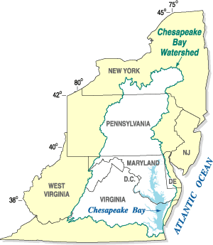 A partial list of Mid-Atlantic States
Ceramics follows:
Some of the more studied sites include:
Europe
Europe is, by convention, one of the world's seven continents. Comprising the westernmost peninsula of Eurasia, Europe is generally 'divided' from Asia to its east by the watershed divides of the Ural and Caucasus Mountains, the Ural River, the Caspian and Black Seas, and the waterways connecting...
ans in early 17th century. Hunters ventured into West Virginia's mountain valleys making temporary camp villages since the Archaic period in the Americas. Many ancient human-made earthen mounds from various mound builder cultures survive, especially in the areas of Moundsville
Moundsville, West Virginia
Moundsville is a city in Marshall County, West Virginia, along the Ohio River. It is part of the Wheeling Metropolitan Statistical Area. The population was 9,998 at the 2000 census. It is the county seat of Marshall County. The city was named for the Grave Creek Mound. Moundsville was settled in...
, South Charleston
South Charleston, West Virginia
South Charleston is a city in Kanawha County, West Virginia, U.S. The population was 13,450 at the 2010 census. South Charleston was established in 1906, but not incorporated until 1919 by special charter enacted by the West Virginia Legislature...
, and Romney
Romney, West Virginia
Romney is a city in and the county seat of Hampshire County, West Virginia, United States. The population was 1,940 at the 2000 census, while the area covered by the city's ZIP code had a population of 5,873. It is a city with a very historic background dating back to the 18th century...
. The artifacts uncovered in these give evidence of a village society having a tribal trade system culture that practiced limited cold worked
Work hardening
Work hardening, also known as strain hardening or cold working, is the strengthening of a metal by plastic deformation. This strengthening occurs because of dislocation movements within the crystal structure of the material. Any material with a reasonably high melting point such as metals and...
copper
Copper
Copper is a chemical element with the symbol Cu and atomic number 29. It is a ductile metal with very high thermal and electrical conductivity. Pure copper is soft and malleable; an exposed surface has a reddish-orange tarnish...
. As of 2009, over 12,500 archaeological sites have been documented in Virginia.
Origins
Northern Panhandle of West Virginia
The Northern Panhandle is a culturally and geographically distinct region in the U.S. state of West Virginia. It is the state's northernmost extension, bounded by the Ohio River on the north and west, along with the state of Pennsylvania on the east...
, the Eastern Panhandle
Eastern Panhandle of West Virginia
The Eastern Panhandle of West Virginia is a narrow stretch of territory in the northeast of the state, bordering Maryland and Virginia, United States. The Eastern Panhandle Board of Realtors and other local civic organizations consider only the three Easternmost counties, Jefferson, Berkeley and...
, and the Kanawha River
Kanawha River
The Kanawha River is a tributary of the Ohio River, approximately 97 mi long, in the U.S. state of West Virginia. The largest inland waterway in West Virginia, it has formed a significant industrial region of the state since the middle of the 19th century.It is formed at the town of Gauley...
Valley. They created temporary villages on the Kanawha region streams, Monongahela
Monongahela River
The Monongahela River is a river on the Allegheny Plateau in north-central West Virginia and southwestern Pennsylvania in the United States...
and Potomac
Potomac River
The Potomac River flows into the Chesapeake Bay, located along the mid-Atlantic coast of the United States. The river is approximately long, with a drainage area of about 14,700 square miles...
tributaries streams of the Allegheny Mountains
Allegheny Mountains
The Allegheny Mountain Range , also spelled Alleghany, Allegany and, informally, the Alleghenies, is part of the vast Appalachian Mountain Range of the eastern United States and Canada...
. The early archaic people used atlatl
Atlatl
An atlatl or spear-thrower is a tool that uses leverage to achieve greater velocity in dart-throwing.It consists of a shaft with a cup or a spur at the end that supports and propels the butt of the dart. The atlatl is held in one hand, gripped near the end farthest from the cup...
s.
Local cultural anthropologists abstracts having preliminary interpretation provide clues of the spread of cultural items, or trait
Trait
Trait may refer to:* Trait, a characteristic or property of some object* Trait , which involve genes and characteristics of organisms* Trait theory, an approach to the psychological study of personality...
s of idea and material found in collective identities, as suspected exchange through inter-cultural middleman trade, migration, direct trade and intermarriage, enslavement after warfare or simply mutual absorption between the prehistoric peoples.
Geography
Physiographic regions of the world
The physiographic regions of the world are a means of defining the Earth's landforms into distinct regions based upon classic 1916 three-tiered approach defining divisions, provinces, and sections...
s of the unglaciated Allegheny Plateau
Allegheny Plateau
The Allegheny Plateau is a large dissected plateau area in western and central New York, northern and western Pennsylvania, northern and western West Virginia, and eastern Ohio...
, which includes parts of the Allegheny Front
Allegheny Front
The Allegheny Front is the major southeast- or east-facing escarpment in the Allegheny Mountains in southern Pennsylvania, western Maryland, and eastern West Virginia, USA. The Allegheny Front delineates the Ridge-and-Valley Appalachians to its east from the Appalachian Plateau to its west...
and Ridge-and-Valley Appalachians
Ridge-and-valley Appalachians
The Ridge-and-Valley Appalachians, also called the Ridge and Valley Province or the Valley and Ridge Appalachians, are a physiographic province of the larger Appalachian division and are also a belt within the Appalachian Mountains extending from southeastern New York through northwestern New...
. These western hills along the Ohio Valley climb east up tributary streams to the base of the Allegheny Mountains
Allegheny Mountains
The Allegheny Mountain Range , also spelled Alleghany, Allegany and, informally, the Alleghenies, is part of the vast Appalachian Mountain Range of the eastern United States and Canada...
. The lowest altitude averages 550 to 600 ft (167.6 to 182.9 m) above the sea, southwest bottoms along the Ohio River
Ohio River
The Ohio River is the largest tributary, by volume, of the Mississippi River. At the confluence, the Ohio is even bigger than the Mississippi and, thus, is hydrologically the main stream of the whole river system, including the Allegheny River further upstream...
(normal pool 538 feet (164 m)). Below the E slopes of the Allegheny Front
Allegheny Front
The Allegheny Front is the major southeast- or east-facing escarpment in the Allegheny Mountains in southern Pennsylvania, western Maryland, and eastern West Virginia, USA. The Allegheny Front delineates the Ridge-and-Valley Appalachians to its east from the Appalachian Plateau to its west...
approximately 2600 to 4700 ft (792.5 to 1,432.6 m) peaks passing down the Potomac River
Potomac River
The Potomac River flows into the Chesapeake Bay, located along the mid-Atlantic coast of the United States. The river is approximately long, with a drainage area of about 14,700 square miles...
on the Eastern Panhandle of West Virginia
Eastern Panhandle of West Virginia
The Eastern Panhandle of West Virginia is a narrow stretch of territory in the northeast of the state, bordering Maryland and Virginia, United States. The Eastern Panhandle Board of Realtors and other local civic organizations consider only the three Easternmost counties, Jefferson, Berkeley and...
are similar land altitudes having relief of up to c. 2000 feet (609.6 m). The plateau
Plateau
In geology and earth science, a plateau , also called a high plain or tableland, is an area of highland, usually consisting of relatively flat terrain. A highly eroded plateau is called a dissected plateau...
reach from the southeastern Ohio through western West Virginia easterly to the physiographic province, Ridge-and-Valley Appalachians, became dissected with a summit level ranging from about 1200 to 1800 ft (365.8 to 548.6 m).
In the west-central part of the state, the colder streams, with mountain trout, form the deeper warm water brooks and smaller river
River
A river is a natural watercourse, usually freshwater, flowing towards an ocean, a lake, a sea, or another river. In a few cases, a river simply flows into the ground or dries up completely before reaching another body of water. Small rivers may also be called by several other names, including...
s that feed the Ohio River, in the Plateau. The highest peaks today in the state are over 4800 feet (1,463 m). The Allegheny Mountains have no volcanic peaks and are rather quiet with very little and unnoticeable earth quake activity. The state mountains were formed by an Orogeny
Orogeny
Orogeny refers to forces and events leading to a severe structural deformation of the Earth's crust due to the engagement of tectonic plates. Response to such engagement results in the formation of long tracts of highly deformed rock called orogens or orogenic belts...
effect of the North American Plate
North American Plate
The North American Plate is a tectonic plate covering most of North America, Greenland, Cuba, Bahamas, and parts of Siberia, Japan and Iceland. It extends eastward to the Mid-Atlantic Ridge and westward to the Chersky Range in eastern Siberia. The plate includes both continental and oceanic crust...
. The Taconic Orogeny
Taconic orogeny
The Taconic orogeny was a mountain building period that ended 440 million years ago and affected most of modern-day New England. A great mountain chain formed from eastern Canada down through what is now the Piedmont of the East coast of the United States...
near the end of Ordovician
Ordovician
The Ordovician is a geologic period and system, the second of six of the Paleozoic Era, and covers the time between 488.3±1.7 to 443.7±1.5 million years ago . It follows the Cambrian Period and is followed by the Silurian Period...
time formed a much higher mountainous area in E West Virginia approximately 350 million to 300 million years ago in the Carboniferous
Carboniferous
The Carboniferous is a geologic period and system that extends from the end of the Devonian Period, about 359.2 ± 2.5 Mya , to the beginning of the Permian Period, about 299.0 ± 0.8 Mya . The name is derived from the Latin word for coal, carbo. Carboniferous means "coal-bearing"...
period. The plateau and mountains have a long history of erosion and throughout the region before peaking formation. The West Virginia Geological and Economic Survey in 2006, "These highlands formed the main source of sediments for the succeeding Silurian Period (ca. 443 million years ago) and part of the Devonian Period (c. 416 million years ago)." Devonian was about the time lobe-finned fish developed legs (Tiktaalik
Tiktaalik
Tiktaalik is a genus of extinct sarcopterygian from the late Devonian period, with many features akin to those of tetrapods . It is an example from several lines of ancient sarcopterygian "fish" developing adaptations to the oxygen-poor shallow-water habitats of its time, which led to the...
) as they started to walk on land
Landform
A landform or physical feature in the earth sciences and geology sub-fields, comprises a geomorphological unit, and is largely defined by its surface form and location in the landscape, as part of the terrain, and as such, is typically an element of topography...
as tetrapod
Tetrapod
Tetrapods are vertebrate animals having four limbs. Amphibians, reptiles, birds and mammals are all tetrapods; even snakes and other limbless reptiles and amphibians are tetrapods by descent. The earliest tetrapods evolved from the lobe-finned fishes in the Devonian...
s. The Mesozoic Era (c. 250 to ca. 67 million years ago) of the Age of Dinosaurs is marked by Cretaceous–Tertiary extinction event and following Cenozoic Era with the dominant terrestrial vertebrates mammals from ca. 65.5 million years ago to the present— the Age of Mammals. Some of these ancient animal
Animal
Animals are a major group of multicellular, eukaryotic organisms of the kingdom Animalia or Metazoa. Their body plan eventually becomes fixed as they develop, although some undergo a process of metamorphosis later on in their life. Most animals are motile, meaning they can move spontaneously and...
evidence are found as fossil
Fossil
Fossils are the preserved remains or traces of animals , plants, and other organisms from the remote past...
between the geologic strata near the abundant sections of coal seams
Coal mining
The goal of coal mining is to obtain coal from the ground. Coal is valued for its energy content, and since the 1880s has been widely used to generate electricity. Steel and cement industries use coal as a fuel for extraction of iron from iron ore and for cement production. In the United States,...
and nearby natural gas
Natural gas
Natural gas is a naturally occurring gas mixture consisting primarily of methane, typically with 0–20% higher hydrocarbons . It is found associated with other hydrocarbon fuel, in coal beds, as methane clathrates, and is an important fuel source and a major feedstock for fertilizers.Most natural...
(fossil fuel
Fossil fuel
Fossil fuels are fuels formed by natural processes such as anaerobic decomposition of buried dead organisms. The age of the organisms and their resulting fossil fuels is typically millions of years, and sometimes exceeds 650 million years...
ranges) in the state.
The Quaternary
Quaternary
The Quaternary Period is the most recent of the three periods of the Cenozoic Era in the geologic time scale of the ICS. It follows the Neogene Period, spanning 2.588 ± 0.005 million years ago to the present...
ice age (2.6 million BCE) began about the time of Pleistocene Epoch. The weather had been by far milder. Sitting snugly in the then much higher mountains was Glacial Teays Lake, extending from south Virginia through the New KanawhaRriver to its northerly drainage river, the ancient Teays River
Teays River
The Teays River was an important preglacial river that drained much of the area now drained by the Ohio River, and more. Traces of the Teays across northern Ohio and Indiana are represented by a network of river valleys. These valleys were carved in the late Cenozoic and eventually led to the...
. It flowed through Ohio
Ohio
Ohio is a Midwestern state in the United States. The 34th largest state by area in the U.S.,it is the 7th‑most populous with over 11.5 million residents, containing several major American cities and seven metropolitan areas with populations of 500,000 or more.The state's capital is Columbus...
to central Indiana
Indiana
Indiana is a US state, admitted to the United States as the 19th on December 11, 1816. It is located in the Midwestern United States and Great Lakes Region. With 6,483,802 residents, the state is ranked 15th in population and 16th in population density. Indiana is ranked 38th in land area and is...
across Illinois
Illinois
Illinois is the fifth-most populous state of the United States of America, and is often noted for being a microcosm of the entire country. With Chicago in the northeast, small industrial cities and great agricultural productivity in central and northern Illinois, and natural resources like coal,...
to the Mississippi Valley. Lying on the north was the Pittsburgh drainage basin. The Mississippi River at the time was an embayment of the Gulf of Mexico
Gulf of Mexico
The Gulf of Mexico is a partially landlocked ocean basin largely surrounded by the North American continent and the island of Cuba. It is bounded on the northeast, north and northwest by the Gulf Coast of the United States, on the southwest and south by Mexico, and on the southeast by Cuba. In...
reaching to Illinois. Glacial Teays Lake last occurrence was about two million years ago when it outburst and the wash build up created the final large prehistoric lake in the western of the state. Lake Tight lasted only c. 6500 years before it outburst forming the Ohio Valley. The Ohio-Allegheny system (Ohio Valley) on the western half of the state was in its present form by the Middle Pleistocene
Middle Pleistocene
The Middle Pleistocene, more specifically referred to as the Ionian stage, is a period of geologic time from ca. 781 to 126 thousand years ago....
, ca. 781–126 thousand years ago. The remaining glacial lake in the northern area of the state was the glacial Monongahela Lake. It had been blocked by ice terraces or ice sheets in the north and western Pennsylvania. Upon ice retreat, it outburst through the basin to the north. It would reform with the next re-advancing glacial ice drift, ground rise and again, another late last occurrence with outwash build-up.
The last maximum extent (LGM
Last Glacial Maximum
The Last Glacial Maximum refers to a period in the Earth's climate history when ice sheets were at their maximum extension, between 26,500 and 19,000–20,000 years ago, marking the peak of the last glacial period. During this time, vast ice sheets covered much of North America, northern Europe and...
) of glaciation was approximately 18,000 years ago. This last returning advancement of glacial ice approaching the Ohio Valley began c. 30,000 years ago. West Virginia had no Ice Sheet buildup. Although during the Last Ice Age, smaller glaciation impounded lakes continued to collect precipitation on the plateau. These chilly lakes among mountain peaks were separated from the continental ice sheet to the north. The deeply carved river valleys like the upper Canaan Valley
Canaan Valley
Canaan Valley is an oval, bowl-like upland valley in northeastern Tucker County, West Virginia, USA. Within it are extensive wetlands and the headwaters of the Blackwater River which spills out of the valley at Blackwater Falls...
to Blackwater Canyon
Blackwater Canyon
Blackwater Canyon is a rugged, heavily-wooded, eight-mile long gorge carved by the Blackwater River in the Allegheny Mountains of eastern West Virginia, USA...
and the Dolly Sods Wilderness
Dolly Sods Wilderness
The Dolly Sods Wilderness — originally simply Dolly Sods — is a U.S. Wilderness Area in the Allegheny Mountains of eastern West Virginia, USA, and is part of the Monongahela National Forest of the U.S. Forest Service ....
to Cheat River
Cheat River
The Cheat River is a tributary of the Monongahela River in eastern West Virginia and southwestern Pennsylvania in the United States. Via the Monongahela and Ohio rivers, it is part of the Mississippi River watershed, ultimately draining into the Gulf of Mexico.-Geography:The Cheat is formed at...
areas are called Paleozoic Plateaus. The "Driftless Area" drains into rivers having rugged regions of bluffs and valleys. According to the West Virginia Geological and Economic Survey, the two large Ice Age lakes varied throughout the epoch. The last glacial lake, Monongahela, occurrence in West Virginia "Carbon-14 dates of c. 22,000, 23,000, and 39,000 years old". It reached as far south as Weston
Weston, West Virginia
Weston is a city in Lewis County, West Virginia, United States. The population was 4,317 at the 2000 census. It is the county seat of Lewis County, and home to the West Virginia Museum of American Glass.-History:...
into the state. Monongahela lake redeveloped and overflowed perhaps at several places as its age is older than 780,000 years BP (WVGES 2005). The first ice-damming event was a pre-Illinoian (Stage) lake which outburst during the earlier ice retreat towards the northwest Pittsburgh drainage direction. The last occurrence of the Monongahela Lake an outwash gravel dam backed up slackwater at Allegheny-Monongahela confluence during an Illinoian ponding event last glacial retreat. The last outburst drained to its present coarse, the central Allegheny Mountains or northern tributaries of the state feeding the Monongahela River to the Ohio River.
The Cirque
Cirque
Cirque may refer to:* Cirque, a geological formation* Makhtesh, an erosional landform found in the Negev desert of Israel and Sinai of Egypt*Cirque , an album by Biosphere* Cirque Corporation, a company that makes touchpads...
and Tarn (lake)
Tarn (lake)
A tarn is a mountain lake or pool, formed in a cirque excavated by a glacier. A moraine may form a natural dam below a tarn. A corrie may be called a cirque.The word is derived from the Old Norse word tjörn meaning pond...
were among heads of smaller outwashes through the Allegheny Plateau. Some of these backed waters cut through leaving higher flatland or terraces among ridge tops above the major river bottoms of which runoff sheds. Higher in the state is Cranberry Glades example lay between Mountain ridge top and peeks with five small, boreal
Boreal ecosystem
The term boreal is usually applied to ecosystems localized in subarctic and subantarctic zones, although Austral is also used for the latter....
-type bog
Bog
A bog, quagmire or mire is a wetland that accumulates acidic peat, a deposit of dead plant material—often mosses or, in Arctic climates, lichens....
s. These feed the mountain river, Cranberry River
Cranberry River (West Virginia)
The Cranberry River is a tributary of the Gauley River located in southeastern West Virginia, USA. It is a part of the Mississippi River watershed, by way of the Gauley, Kanawha, and Ohio Rivers, draining an area of ....
, a trout
Trout
Trout is the name for a number of species of freshwater and saltwater fish belonging to the Salmoninae subfamily of the family Salmonidae. Salmon belong to the same family as trout. Most salmon species spend almost all their lives in salt water...
-holding biom. From these various mountain and hill formations, the Allegheny Plateau
Allegheny Plateau
The Allegheny Plateau is a large dissected plateau area in western and central New York, northern and western Pennsylvania, northern and western West Virginia, and eastern Ohio...
has eroded and settled. In Pennsylvania the Titusville Till, results of very ancient Monongahela lake sediment, has an age of c. 40,000 years. There are several different strata of till layers across the region. Outflow of melt and weather contributed to the hill and mountain erosion. On top of the layers of geologic strata, settled drifts of kame or gravel shoals lay under soil sediments along the valley bottoms. "As one proceeds westward, the rocks are younger and younger," states Peter Lessing, July 1996, West Virginia Geological and Economic Survey. Below outcrops of the Paleozoic Plateaus are the largest kind of sediment by erosion, the large boulders peeking above the rivers surface. A variety of stone
Rock (geology)
In geology, rock or stone is a naturally occurring solid aggregate of minerals and/or mineraloids.The Earth's outer solid layer, the lithosphere, is made of rock. In general rocks are of three types, namely, igneous, sedimentary, and metamorphic...
of geology
Geology
Geology is the science comprising the study of solid Earth, the rocks of which it is composed, and the processes by which it evolves. Geology gives insight into the history of the Earth, as it provides the primary evidence for plate tectonics, the evolutionary history of life, and past climates...
for lithic tool making is found across the state in valleys (Brockman, US Forest Service, 2003). From these stone, artifacts are found providing evidence Paleo-Indians were passing through West Virginia. State universities and the U.S. Geological Survey Paleoanthropologists have found evidence of early Archaic people habitation during Holocene Climate Optimum—a rough interval of 9,000 to 5,000 years B.P.
Ecosystems and Migration
The state's ecosystems influenced the movement of the semi-nomadic Archaic Indian. The land gradually changed from a tundraTundra
In physical geography, tundra is a biome where the tree growth is hindered by low temperatures and short growing seasons. The term tundra comes through Russian тундра from the Kildin Sami word tūndâr "uplands," "treeless mountain tract." There are three types of tundra: Arctic tundra, alpine...
to an evergreen forest, or taiga
Taiga
Taiga , also known as the boreal forest, is a biome characterized by coniferous forests.Taiga is the world's largest terrestrial biome. In North America it covers most of inland Canada and Alaska as well as parts of the extreme northern continental United States and is known as the Northwoods...
, and eventually to a forests of oak, hemlock, rhododendron
Rhododendron
Rhododendron is a genus of over 1 000 species of woody plants in the heath family, most with showy flowers...
, nut, berries, and Appalachian mixed mesophytic forests
Appalachian mixed mesophytic forests
The Appalachian mixed mesophytic forests are an ecoregion of mesophytic plants west of the Appalachian Mountains in the southeastern United States.-Setting:...
. By 7800 BCE, the vegetation attracted modern game animals. Modern decididuous forests grew south and east of the Allegheny. Carbonized nut hulls from the St. Albans Site
St. Albans Site
St. Albans Site is a historic archaeological site located near St. Albans, Kanawha County, West Virginia. It was a camping site for prehistoric peoples between c. 12,000 B.C. and A.D. 1700. Excavations in 1964-1965, yielded projectile points ranging in age from 7900 t o 6210 B.C.It was listed on...
(46Ka61) in Kanawha County date to 7000 BCE.
The New River (Kanawha River) flows from the Ridge and Valley Province
Ridge-and-valley Appalachians
The Ridge-and-Valley Appalachians, also called the Ridge and Valley Province or the Valley and Ridge Appalachians, are a physiographic province of the larger Appalachian division and are also a belt within the Appalachian Mountains extending from southeastern New York through northwestern New...
, and the head of the Tennessee River
Tennessee River
The Tennessee River is the largest tributary of the Ohio River. It is approximately 652 miles long and is located in the southeastern United States in the Tennessee Valley. The river was once popularly known as the Cherokee River, among other names...
, (Powell, Clinch
Clinch River
The Clinch River rises in Southwest Virginia near Tazewell, Virginia and flows southwest through the Great Appalachian Valley, gathering various tributaries including the Powell River before joining the Tennessee River in East Tennessee.-Course:...
and Holston
Holston River
The Holston River is a major river system of southwestern Virginia and east Tennessee. The three major forks of the Holston rise in southwestern Virginia and have their confluence near Kingsport, Tennessee. The North Fork flows southwest from Sharon Springs in Bland County, Virginia...
Valleys) drain southwesterly the Ridge and Valley Province. The upper branches of the Big Sandy River
Big Sandy River (Ohio River)
The Big Sandy River is a tributary of the Ohio River, approximately long, in western West Virginia and northeastern Kentucky in the United States. The river forms part of the boundary between the two states along its entire course...
drains this province's northern slopes. While emptying near the mouth of the Ohio River
Ohio River
The Ohio River is the largest tributary, by volume, of the Mississippi River. At the confluence, the Ohio is even bigger than the Mississippi and, thus, is hydrologically the main stream of the whole river system, including the Allegheny River further upstream...
, the Tennessee River
Tennessee River
The Tennessee River is the largest tributary of the Ohio River. It is approximately 652 miles long and is located in the southeastern United States in the Tennessee Valley. The river was once popularly known as the Cherokee River, among other names...
and north Cumberland River
Cumberland River
The Cumberland River is a waterway in the Southern United States. It is long. It starts in Harlan County in far southeastern Kentucky between Pine and Cumberland mountains, flows through southern Kentucky, crosses into northern Tennessee, and then curves back up into western Kentucky before...
reaches from the west-draining Cumberland Plateau
Cumberland Plateau
The Cumberland Plateau is the southern part of the Appalachian Plateau. It includes much of eastern Kentucky and western West Virginia, part of Tennessee, and a small portion of northern Alabama and northwest Georgia . The terms "Allegheny Plateau" and the "Cumberland Plateau" both refer to the...
opposite the Big Sandy watershed. The Tennessee River reaches easterly to the Ridge and Valley Province of the Great Smoky Mountains
Great Smoky Mountains
The Great Smoky Mountains are a mountain range rising along the Tennessee–North Carolina border in the southeastern United States. They are a subrange of the Appalachian Mountains, and form part of the Blue Ridge Physiographic Province. The range is sometimes called the Smoky Mountains or the...
, part of the Blue Ridge Mountains
Blue Ridge Mountains
The Blue Ridge Mountains are a physiographic province of the larger Appalachian Mountains range. This province consists of northern and southern physiographic regions, which divide near the Roanoke River gap. The mountain range is located in the eastern United States, starting at its southern-most...
which are a division of the larger Appalachian Mountain chain
Appalachian Mountains
The Appalachian Mountains #Whether the stressed vowel is or ,#Whether the "ch" is pronounced as a fricative or an affricate , and#Whether the final vowel is the monophthong or the diphthong .), often called the Appalachians, are a system of mountains in eastern North America. The Appalachians...
. The Potomac River
Potomac River
The Potomac River flows into the Chesapeake Bay, located along the mid-Atlantic coast of the United States. The river is approximately long, with a drainage area of about 14,700 square miles...
, James River
James River
The James River may refer to:Rivers in the United States and their namesakes* James River * James River , North Dakota, South Dakota* James River * James River * James River...
and Dan River
Dan River
The Dan River flows in the U.S. states of North Carolina and Virginia. It originates in Patrick County, Virginia, and crosses the state border into Stokes County, North Carolina. It then flows into Rockingham County. From there it goes back into Virginia. It reenters North Carolina near the...
basins drain the eastern slopes of these mountain ranges. Ancient mountain trails through eastern Kentucky
Kentucky
The Commonwealth of Kentucky is a state located in the East Central United States of America. As classified by the United States Census Bureau, Kentucky is a Southern state, more specifically in the East South Central region. Kentucky is one of four U.S. states constituted as a commonwealth...
and West Virginia
West Virginia
West Virginia is a state in the Appalachian and Southeastern regions of the United States, bordered by Virginia to the southeast, Kentucky to the southwest, Ohio to the northwest, Pennsylvania to the northeast and Maryland to the east...
allowed Native American passage between the northern Till Plains of Illinois
Illinois
Illinois is the fifth-most populous state of the United States of America, and is often noted for being a microcosm of the entire country. With Chicago in the northeast, small industrial cities and great agricultural productivity in central and northern Illinois, and natural resources like coal,...
, Indiana
Indiana
Indiana is a US state, admitted to the United States as the 19th on December 11, 1816. It is located in the Midwestern United States and Great Lakes Region. With 6,483,802 residents, the state is ranked 15th in population and 16th in population density. Indiana is ranked 38th in land area and is...
and Ohio
Ohio
Ohio is a Midwestern state in the United States. The 34th largest state by area in the U.S.,it is the 7th‑most populous with over 11.5 million residents, containing several major American cities and seven metropolitan areas with populations of 500,000 or more.The state's capital is Columbus...
, otherwise a part of the Corn Belt
Corn Belt
The Corn Belt is a region of the Midwestern United States where corn has, since the 1850s, been the predominant crop, replacing the native tall grasses. By 1950, 99% of the corn was grown from hybrids. Most corn is fed to livestock, especially hogs and poultry. In recent decades soybeans have...
or Midwestern United States
Midwestern United States
The Midwestern United States is one of the four U.S. geographic regions defined by the United States Census Bureau, providing an official definition of the American Midwest....
and the Piedmont Plateau, and Atlantic Ocean
Atlantic Ocean
The Atlantic Ocean is the second-largest of the world's oceanic divisions. With a total area of about , it covers approximately 20% of the Earth's surface and about 26% of its water surface area...
coastal plains. Trails through the region facilitated migration, trade, warface, and hunting.
Between 10,800 and 9500 BCE, the continental glaciers retreated north of the Great Lakes
Great Lakes
The Great Lakes are a collection of freshwater lakes located in northeastern North America, on the Canada – United States border. Consisting of Lakes Superior, Michigan, Huron, Erie, and Ontario, they form the largest group of freshwater lakes on Earth by total surface, coming in second by volume...
. Glacial lake outburst flood
Glacial lake outburst flood
A glacial lake outburst flood is a type of outburst flood that occurs when the dam containing a glacial lake fails. The dam can consist of glacier ice or a terminal moraine...
s occurred during the melt outflow. The Allegheny Mountains, which have no volcanic peaks, were was formed by an Orogeny
Orogeny
Orogeny refers to forces and events leading to a severe structural deformation of the Earth's crust due to the engagement of tectonic plates. Response to such engagement results in the formation of long tracts of highly deformed rock called orogens or orogenic belts...
effect of the North American Plate
North American Plate
The North American Plate is a tectonic plate covering most of North America, Greenland, Cuba, Bahamas, and parts of Siberia, Japan and Iceland. It extends eastward to the Mid-Atlantic Ridge and westward to the Chersky Range in eastern Siberia. The plate includes both continental and oceanic crust...
.
Flooding disturbed archaeological layers of lithics and ceramics in the alluvium of the south branch of the Potomac at the Romney
Romney, West Virginia
Romney is a city in and the county seat of Hampshire County, West Virginia, United States. The population was 1,940 at the 2000 census, while the area covered by the city's ZIP code had a population of 5,873. It is a city with a very historic background dating back to the 18th century...
bridge replacement archaeological site. Early Lake Erie
Early Lake Erie
Early Lake Erie was a prehistoric proglacial lake that existed at the end of the last ice age approximately 13,000 years ago. The early Erie fed waters to Glacial Lake Iroquois....
, which were Lake Michigan
Lake Michigan
Lake Michigan is one of the five Great Lakes of North America and the only one located entirely within the United States. It is the second largest of the Great Lakes by volume and the third largest by surface area, after Lake Superior and Lake Huron...
and Lake Erie
Lake Erie
Lake Erie is the fourth largest lake of the five Great Lakes in North America, and the tenth largest globally. It is the southernmost, shallowest, and smallest by volume of the Great Lakes and therefore also has the shortest average water residence time. It is bounded on the north by the...
combined, flowed west out Little River (Great Black Swamp
Great Black Swamp
The Great Black Swamp, or simply Black Swamp, was a glacially caused wetland in northwest Ohio, United States, extending into extreme northeastern Indiana, that existed from the end of the Wisconsin glaciation until the late 19th century...
proglacial lake's drainage embayment and the Wabash River
Wabash River
The Wabash River is a river in the Midwestern United States that flows southwest from northwest Ohio near Fort Recovery across northern Indiana to southern Illinois, where it forms the Illinois-Indiana border before draining into the Ohio River, of which it is the largest northern tributary...
before changing direction to the east into Glacial Lake Iroquois
Glacial Lake Iroquois
Glacial Lake Iroquois was a prehistoric proglacial lake that existed at the end of the last ice age approximately 13,000 years ago.The lake was essentially an enlargement of the present Lake Ontario that formed because the St. Lawrence River downstream from the lake was blocked by the ice sheet...
. Earlier sediments built up event outburst near the Little River more than once which altered the drainage direction and the remaining Great Black Swamp. 3000 years ago, Lake Michigan and Lake Erie assumed their present shapes. Lake Erie's water level was similar to Lake Nipioing phase of Lakes Michigan and Huron
Lake Huron
Lake Huron is one of the five Great Lakes of North America. Hydrologically, it comprises the larger portion of Lake Michigan-Huron. It is bounded on the east by the Canadian province of Ontario and on the west by the state of Michigan in the United States...
basins 5,000 years BP. By 3500 years BP, the level had lowered by four meters and by 2000 BP the level had increased to possibly five meters above today's levels. Hopewell culture
Hopewell culture
The Hopewell tradition is the term used to describe common aspects of the Native American culture that flourished along rivers in the northeastern and midwestern United States from 200 BCE to 500 CE. The Hopewell tradition was not a single culture or society, but a widely dispersed set of related...
arrived from the north in west central Ohio and Indiana by 2000 BP. Earlier trading peoples, also from the north, a vanguard Armstrong variant in southwest West Virginia mingled peacefully with Late Adena peoples. Cold-worked copper
Copper
Copper is a chemical element with the symbol Cu and atomic number 29. It is a ductile metal with very high thermal and electrical conductivity. Pure copper is soft and malleable; an exposed surface has a reddish-orange tarnish...
from the pits in Wisconsin
Wisconsin
Wisconsin is a U.S. state located in the north-central United States and is part of the Midwest. It is bordered by Minnesota to the west, Iowa to the southwest, Illinois to the south, Lake Michigan to the east, Michigan to the northeast, and Lake Superior to the north. Wisconsin's capital is...
Old Copper Complex
Old Copper Complex
Old Copper Complex is a term used for ancient Native North American societies known to have been heavily involved in the utilization of copper for weaponry and tools. It is to be distinguished from the Copper Age , when copper use becomes systematic.The Old Copper Complex of the Western Great Lakes...
region have been found in some Adena mounds. The Upper Ohio Valley was experiencing the Sub-Atlantic climatic phase (3000-1750 BP) of warm and moist climatic conditions and stable stream levels upon the occurrence of the Hopewell culture
Hopewell culture
The Hopewell tradition is the term used to describe common aspects of the Native American culture that flourished along rivers in the northeastern and midwestern United States from 200 BCE to 500 CE. The Hopewell tradition was not a single culture or society, but a widely dispersed set of related...
. This climatic phase began after the much earlier arise of indigenous Early Adena Culture
Adena culture
The Adena culture was a Pre-Columbian Native American culture that existed from 1000 to 200 BC, in a time known as the early Woodland Period. The Adena culture refers to what were probably a number of related Native American societies sharing a burial complex and ceremonial system...
(46MR7, 1735 BCE) in West Virginia.
Paleoclimatology
Paleoclimatology
Paleoclimatology is the study of changes in climate taken on the scale of the entire history of Earth. It uses a variety of proxy methods from the Earth and life sciences to obtain data previously preserved within rocks, sediments, ice sheets, tree rings, corals, shells and microfossils; it then...
is the study of prehistoric weather. The Eemian interglacial period spanned 130,000–114,000 BP. The Laurentide ice sheet
Laurentide ice sheet
The Laurentide Ice Sheet was a massive sheet of ice that covered hundreds of thousands of square miles, including most of Canada and a large portion of the northern United States, multiple times during Quaternary glacial epochs. It last covered most of northern North America between c. 95,000 and...
covered much of Canada and the northern United States from ca. 95,000 and ca. 20,000 years before present. The last advancement of glacial ice sheets in the eastern United States was the Wisconsin Glacial Episode, which caused the ice sheet to advance ended 10,000 years ago.
This freezing period temporarily stopped the ice sheets north of the Great Lakes
Great Lakes
The Great Lakes are a collection of freshwater lakes located in northeastern North America, on the Canada – United States border. Consisting of Lakes Superior, Michigan, Huron, Erie, and Ontario, they form the largest group of freshwater lakes on Earth by total surface, coming in second by volume...
from thawing. It is called the Younger Dryas
Younger Dryas
The Younger Dryas stadial, also referred to as the Big Freeze, was a geologically brief period of cold climatic conditions and drought between approximately 12.8 and 11.5 ka BP, or 12,800 and 11,500 years before present...
Stadial, dating from 10,800–9500 BCE. Temperatures plunged 7 degrees and the sea level sank 100 feet below present level. Nomadic Paleo-Indian arrived in the upper Ohio Valley utilizing the Kanawha Black flint at this time. By ca. 9500 BCE the Younger Dryas suddenly ended and warmer temperatures returned.
The warm period during interval of 7000–3000 BCE is called the Holocene climatic optimum
Holocene climatic optimum
The Holocene Climate Optimum was a warm period during roughly the interval 9,000 to 5,000 years B.P.. This event has also been known by many other names, including: Hypsithermal, Altithermal, Climatic Optimum, Holocene Optimum, Holocene Thermal Maximum, and Holocene Megathermal.This warm period...
and was a period of warm weather. Towards the end of the Archaic period, seasonal weather was a time of Meridional overturning circulation and large storms came up from the Gulf of Mexico
Gulf of Mexico
The Gulf of Mexico is a partially landlocked ocean basin largely surrounded by the North American continent and the island of Cuba. It is bounded on the northeast, north and northwest by the Gulf Coast of the United States, on the southwest and south by Mexico, and on the southeast by Cuba. In...
. The western and northern valleys of West Virginia became warm and dry with less effective precipitation around 2550 BCE, causing the bottom land flora to thin and creating an occasional major flood and serious erosion during the early part transitional weather pattern.
A period of drought was followed by a cool and wet Sub-Boreal climatic phase (4200–3000 BP), a warm and moist Sub-Atlantic climatic phase (3000-1750 BP), Scandic climatic phase (1750-1250 BP), a stable Neo-Atlantic climatic phase (1100-750 BP), and a cool and wet Pacific climatic phase (750 BP, Little Ice Age).
The prevailing weather pattern in the Middle Ohio Valley from 1350–1600 CE was cool and wet, followed by a period of frequent drought
Drought
A drought is an extended period of months or years when a region notes a deficiency in its water supply. Generally, this occurs when a region receives consistently below average precipitation. It can have a substantial impact on the ecosystem and agriculture of the affected region...
s. In contrast, the upper Ohio Valley experienced milder weather patterns. The frequency of droughts in West Virginia increased in the following decades. Drought frequency during 1250-1400 CE is unknown. However, north of the Allegheny Plateau
Allegheny Plateau
The Allegheny Plateau is a large dissected plateau area in western and central New York, northern and western Pennsylvania, northern and western West Virginia, and eastern Ohio...
, the Till Plains
Corn Belt
The Corn Belt is a region of the Midwestern United States where corn has, since the 1850s, been the predominant crop, replacing the native tall grasses. By 1950, 99% of the corn was grown from hybrids. Most corn is fed to livestock, especially hogs and poultry. In recent decades soybeans have...
was less effected by drought.
Two periods mark the rise and decline weather for true agriculture: the Medieval Warm Period
Medieval Warm Period
The Medieval Warm Period , Medieval Climate Optimum, or Medieval Climatic Anomaly was a time of warm climate in the North Atlantic region, that may also have been related to other climate events around the world during that time, including in China, New Zealand, and other countries lasting from...
(800-1300 CE) and the Little Ice Age
Little Ice Age
The Little Ice Age was a period of cooling that occurred after the Medieval Warm Period . While not a true ice age, the term was introduced into the scientific literature by François E. Matthes in 1939...
Period (1400-1900 CE).
Paleo-Indian period
Paleo-Indian culture appears by 10,500 BCE in West Virginia along the major river valleys and ridge-line gap watershedsDrainage basin
A drainage basin is an extent or an area of land where surface water from rain and melting snow or ice converges to a single point, usually the exit of the basin, where the waters join another waterbody, such as a river, lake, reservoir, estuary, wetland, sea, or ocean...
. The New Trout Cave in Pendleton County
Pendleton County, West Virginia
As of the census of 2000, there were 8,196 people, 3,350 households, and 2,355 families residing in the county. The population density was 12 people per square mile . There were 5,102 housing units at an average density of 7 per square mile...
has been studied by archaeologists since 1966 and is one of many Paleo-Indian cave shelters in the region. This ancient cave settlement is near the Lake Maumee. Among the Megafauna
Megafauna
In terrestrial zoology, megafauna are "giant", "very large" or "large" animals. The most common thresholds used are or...
of the region, a few American mastodon
American mastodon
The American mastodon is an extinct North American proboscidean that lived from about 3.7 million years ago until about 10,000 BC. It was the last surviving member of the mastodon family. Fossil finds range from present-day Alaska and New England in the north, to Florida, southern...
teeth have been found on the broader river bottoms in western West Virginia. Wooly mammoths, mastodon
Mastodon
Mastodons were large tusked mammal species of the extinct genus Mammut which inhabited Asia, Africa, Europe, North America and Central America from the Oligocene through Pleistocene, 33.9 mya to 11,000 years ago. The American mastodon is the most recent and best known species of the group...
s, and caribou lived in the Kanawha Valley but died off or migrated north as the climate warmed.
Less than a dozen miles from the Northern Panhandle of West Virginia
Northern Panhandle of West Virginia
The Northern Panhandle is a culturally and geographically distinct region in the U.S. state of West Virginia. It is the state's northernmost extension, bounded by the Ohio River on the north and west, along with the state of Pennsylvania on the east...
is the Meadowcroft Rockshelter. Kanawha Chert from West Virginia was found at Meadowcroft Rockshelter (36WH297) Washington County, Pennsylvania. Kanawha Chert source is 183.4 miles (114 km) southwest of Meadowcroft (Vento and Donahue 1982:116). Quoting, "The lithic raw material data indicate the early inhabitants of Meadowcroft Rockshelter had been in the region long enough to discover local chert sources, but also utilized or exploited materials from a much larger territory than just the local region. Alternatively, the exotic lithic materials may indicate trade with neighboring groups, if they were present at that time." Paleo occupation has been dated from 11,320–14,225 BCE (radiocarbon date, Sciulli 1982:176). Paleo-Indian Clovis culture
Clovis culture
The Clovis culture is a prehistoric Paleo-Indian culture that first appears 11,500 RCYBP , at the end of the last glacial period, characterized by the manufacture of "Clovis points" and distinctive bone and ivory tools...
peoples left fluted Clovis Point
Clovis point
Clovis points are the characteristically-fluted projectile points associated with the North American Clovis culture. They date to the Paleoindian period around 13,500 years ago. Clovis fluted points are named after the city of Clovis, New Mexico, where examples were first found in 1929.At the right...
s in West Virginia. Plano cultures
Plano cultures
The Plano cultures is a name given by archaeologists to a group of disparate hunter-gatherer communities that occupied the Great Plains area of North America during the Paleo-Indian period in the United States and the Paleo-Indian or Archaic period in Canada....
(8000-7000 BCE) which followed Clovis knapped spear points lacking the groove or flute of the earlier Clovis Point. Plano peoples moved westward and hunted bison on the High Plains extending to Ohio and into the early Archaic time period. The Dalton Tradition
Dalton Tradition
The Dalton Tradition is a Late Paleo-Indian and Early Archaic projectile point tradition. These points appeared in most of Southeast North America around 8500-7900 BC.-References:*Fagan, Brian. Ancient North America. Thames & Hudson Ltd: London. 2005...
(8500-7900 BCE) represents another technical shift, characterized by a particular type of adz. The earliest stone point surface finds, like the Dalton
Dalton Tradition
The Dalton Tradition is a Late Paleo-Indian and Early Archaic projectile point tradition. These points appeared in most of Southeast North America around 8500-7900 BC.-References:*Fagan, Brian. Ancient North America. Thames & Hudson Ltd: London. 2005...
variants (8700–8200 BCE), are very rare.
Paleo-Indians lived in eastern North America by 6000 BCE, and by 4000 BCE had clearly differentiated into two groups: the southern archaic Isawnid (Indian Knoll culture of Kentucky) and the northern archaic Lenid (Great Lakes
Great Lakes
The Great Lakes are a collection of freshwater lakes located in northeastern North America, on the Canada – United States border. Consisting of Lakes Superior, Michigan, Huron, Erie, and Ontario, they form the largest group of freshwater lakes on Earth by total surface, coming in second by volume...
Area) peoples
Archaic period
Hunter-gatherer
A hunter-gatherer or forage society is one in which most or all food is obtained from wild plants and animals, in contrast to agricultural societies which rely mainly on domesticated species. Hunting and gathering was the ancestral subsistence mode of Homo, and all modern humans were...
s, who fished and gathered wild berries, nuts, seeds, and wild plants. The megafauna had migrated or died out by this time, so people hunted deer, bear, wild turkeys, rabbits, and other small game with atlatl
Atlatl
An atlatl or spear-thrower is a tool that uses leverage to achieve greater velocity in dart-throwing.It consists of a shaft with a cup or a spur at the end that supports and propels the butt of the dart. The atlatl is held in one hand, gripped near the end farthest from the cup...
s and small spears. The atlatls used stone elaborate weights called bannerstone
Bannerstone
Bannerstones are artifacts usually found in the Eastern United States that are characterized by a centered hole in a symmetrically shaped carved or ground stone. The holes are typically ¼” to ¾” in diameter and extend through a raised portion centered in the stone. They usually are bored all the...
s. They used used ground-stone implements and flint
Flint
Flint is a hard, sedimentary cryptocrystalline form of the mineral quartz, categorized as a variety of chert. It occurs chiefly as nodules and masses in sedimentary rocks, such as chalks and limestones. Inside the nodule, flint is usually dark grey, black, green, white, or brown in colour, and...
woodworking tools, as well as bowls of sandstone and soapstone, knives, and net sinkers. In Kanawha Valley, tools were made with Kanawha Black Flint. The Kessell Side Notched point at the St. Albans Site, dated to 7900 BCE, is an examples of a rare, early archaic stone point.
The archaic stone point chronology in the Kanawha Valley generally is as follows:
- Kanawha Points of LeCroy Period (6200-6300 BCE)
- Stanley Period (ca. 5745 BCE)
- Amos Period (4365-4790 BCE)
- Hansford Period (3600-3700 BCE)
- Transitional Period (1000-1200 BCE).
Some Brewerton Phase side and corner-notched points (side-notched tradition) are often found resharpened, and some were modified as hafted end-scrapers. A few uncommon Pointed Pole Adze
Adze
An adze is a tool used for smoothing or carving rough-cut wood in hand woodworking. Generally, the user stands astride a board or log and swings the adze downwards towards his feet, chipping off pieces of wood, moving backwards as they go and leaving a relatively smooth surface behind...
s are thought to have been used for heavy woodworking at one late northern Panhandle Archaic site (2000 BCE), where a dugout canoe has possibly been found.
Regional Archaic
The traditional Archaic sub-periods are Early (8000-6000 BCE), Middle (6000-4000 BCE), and Late Riverton Tradition. The Laurentian Archaic Tradition includes the Brewerton Phase, Feheeley Phase, Dunlop Phase, McKibben Phase, Genesee Phase, Stringtown/Satchel Phase, Satchel Phase, and Lamoka/Dustin Phase.The Red Ocher people and Glacial Kame Culture
Glacial Kame Culture
The Glacial Kame Culture was a culture of Archaic people that occupied southern Ontario, Michigan, Ohio and Indiana from around 8000 BC to 1000 BC. The name of this culture derives from its members' practice of burying their dead atop glacier-deposited gravel hills...
s evolved together resulting in the following traits.
- Small gravel mounds (drainage-way sedimentSedimentSediment is naturally occurring material that is broken down by processes of weathering and erosion, and is subsequently transported by the action of fluids such as wind, water, or ice, and/or by the force of gravity acting on the particle itself....
ary) at first of the Glacial Kame - The introduction of red ocher in burials
- Animal masks and headdresses
- Medicine bags
- Conical tubular pipes
- Grooved axes
- Atlatls now with atlatl weights for better leverage
- Cremation accretion on conical mounds ending the era.
Sometime after 2000 BCE, people built large conical mounds with casks made of small logs at the base. Small conical gravel mounds quickly grew in size as Early Eastern Woodland people, known as the Adena moundbuilders
Adena culture
The Adena culture was a Pre-Columbian Native American culture that existed from 1000 to 200 BC, in a time known as the early Woodland Period. The Adena culture refers to what were probably a number of related Native American societies sharing a burial complex and ceremonial system...
arrived from the east.
Woodland period
The Woodland periodWoodland period
The Woodland period of North American pre-Columbian cultures was from roughly 1000 BCE to 1000 CE in the eastern part of North America. The term "Woodland Period" was introduced in the 1930s as a generic header for prehistoric sites falling between the Archaic hunter-gatherers and the...
spanned 1000 BCE to 1000 CE. The Woodland period is differentiated from the Archaic Period by the emergence of agriculture, cord- or textile-marked pottery, and burial mounds.
Adena culture
Adena culture
The Adena culture was a Pre-Columbian Native American culture that existed from 1000 to 200 BC, in a time known as the early Woodland Period. The Adena culture refers to what were probably a number of related Native American societies sharing a burial complex and ceremonial system...
, which originated in Ohio, flourished from 1000–200 BCE in West Virginia. Adena people practiced agriculture and lived in settled villages. At its cultural zenith, Adena villages spread throughout the Midwestern United States
Midwestern United States
The Midwestern United States is one of the four U.S. geographic regions defined by the United States Census Bureau, providing an official definition of the American Midwest....
and were self-governing and loosely linked by trade.
Adena houses typically were conical structures, about 15–45 feet in diameter, and built around supporting poles, either single or double. Roofs were made of bark and walls could be wickerwork or bark.
Adena crops are part of the Eastern Agricultural Complex
Eastern Agricultural Complex
The Eastern Agricultural Complex describes the agricultural practices of the pre-historic Eastern Woodland Native Americans in the eastern United States and Canada. Native Americans domesticated and cultivated many indigenous crops as far west as the Great Plains.-Term:The term Eastern Agricultural...
. They grew squash, sunflower (Helianthus annuus), sumpweed, goosefoot, knotweed, and maygrass. Gourds were grown for containers and rattles. What might be a small bird pen found one Adena site suggests limited animal domestication, but Adena people are not known for animal husbandry.
Tobacco
Tobacco
Tobacco is an agricultural product processed from the leaves of plants in the genus Nicotiana. It can be consumed, used as a pesticide and, in the form of nicotine tartrate, used in some medicines...
was an important crop and was smoked in effigy pipes. Turtles, ducks, and other animals were represented in Adena art. Limited amount of copper was imported from the western Great Lakes region, and marine shells were imported from the Gulf of Mexico.
Adena nobles wore tanned heads of animals during their ceremonies. They wove coarse cloth, colored with natural dye
Natural dye
Natural dyes are dyes or colorants derived from plants, invertebrates, or minerals. The majority of natural dyes are vegetable dyes from plant sources – roots, berries, bark, leaves, and wood — and other organic sources such as fungi and lichens....
s. Red ochre was placed in elite graves. They altered their appearance with cranial deformation. Cordage was spun from sinew, hide, and fibrous plants.
During the last few centuries Adena zenith (500 BCE), however, a second horizon with political cohesion (Priest Cult) arrived in mass invasion above the Ohio River. Late Adena people fled south of the Ohio, joining their kindred. And, some continued to flee as far as the Chesapeake Bay
Chesapeake Bay
The Chesapeake Bay is the largest estuary in the United States. It lies off the Atlantic Ocean, surrounded by Maryland and Virginia. The Chesapeake Bay's drainage basin covers in the District of Columbia and parts of six states: New York, Pennsylvania, Delaware, Maryland, Virginia, and West...
traditional trade area. A few fled towards the easterly Point Peninsula Woodland culture otherwise Eastern Great Lakes
Great Lakes
The Great Lakes are a collection of freshwater lakes located in northeastern North America, on the Canada – United States border. Consisting of Lakes Superior, Michigan, Huron, Erie, and Ontario, they form the largest group of freshwater lakes on Earth by total surface, coming in second by volume...
trade area. Their mounds progressively become smaller through Virginia
Virginia
The Commonwealth of Virginia , is a U.S. state on the Atlantic Coast of the Southern United States. Virginia is nicknamed the "Old Dominion" and sometimes the "Mother of Presidents" after the eight U.S. presidents born there...
. These soon assimilated with the regional Woodland People friends. The large conical Adena Turkey Creek Mound (46PU2) on the Great Kanawha dates to 886 CE.
Adena mounds
Many Adena mounds were burial sites. The deceased were often cremated and placed in log tombs, which would be covered with dirt, forming the basis of a conical mound.- Camden Park Mound, Cabell County
- Criel MoundCriel MoundThe Criel Mound is a Native American burial mound located in South Charleston, West Virginia, USA. The mound was built by the Adena culture, probably around 250-150 BC, and lay equidistant between two “sacred circles”, earthwork enclosures each in diameter. It was originally high and in...
, Kanawha County, 250–150 BCE - Cresap Mound (46MR7), Marshall County, 1735 BCE
- Cotiga Mound (46MO1), on the Tug Fork of the Big Sandy RiverBig Sandy River (Ohio River)The Big Sandy River is a tributary of the Ohio River, approximately long, in western West Virginia and northeastern Kentucky in the United States. The river forms part of the boundary between the two states along its entire course...
, Mingo County, 1400 BCE - Grave Creek MoundGrave Creek MoundAt high and in diameter, the Grave Creek Mound is one of the largest conical type burial mounds in the United States. The builders of the site moved more than 60,000 tons of dirt to create it. It is located in Moundsville, West Virginia near the banks of the Ohio River. The first recorded...
, Moundsville, 250-150 BCE - St. Albans SiteSt. Albans SiteSt. Albans Site is a historic archaeological site located near St. Albans, Kanawha County, West Virginia. It was a camping site for prehistoric peoples between c. 12,000 B.C. and A.D. 1700. Excavations in 1964-1965, yielded projectile points ranging in age from 7900 t o 6210 B.C.It was listed on...
(46KA27), Kanawha County - Turkey Creek Mound (46PU2), Putnam County
- Goff Mound, Harrison County
- Linden Reynolds Farm Mound, Pleasants County
- St Mary's Mound
The Grave Creek Mound in Moundsville
Moundsville, West Virginia
Moundsville is a city in Marshall County, West Virginia, along the Ohio River. It is part of the Wheeling Metropolitan Statistical Area. The population was 9,998 at the 2000 census. It is the county seat of Marshall County. The city was named for the Grave Creek Mound. Moundsville was settled in...
is the largest mound in the state and was once surrounded by a moat
Moat
A moat is a deep, broad ditch, either dry or filled with water, that surrounds a castle, other building or town, historically to provide it with a preliminary line of defence. In some places moats evolved into more extensive water defences, including natural or artificial lakes, dams and sluices...
. Cresap Mound redefined what constitutes Early to Middle Adena culture
Adena culture
The Adena culture was a Pre-Columbian Native American culture that existed from 1000 to 200 BC, in a time known as the early Woodland Period. The Adena culture refers to what were probably a number of related Native American societies sharing a burial complex and ceremonial system...
(1000 BCE), as opposed to Late Adena (500 BCE).
Other woodland cultures
Fayette County, Pennsylvania
Fayette County is a county located in the U.S. state of Pennsylvania. As of the2010 census, the population was 136,606. The county is part of the Pittsburgh Metropolitan Statistical Area....
several post mold arcs for a pattern to confirm the suggestion of early village houses. Fragile understood and earnest effort, it was not confirmed. The Middle (1-500 CE) and Late Woodland (500-1000 CE) Periods for the Northern Panhandle of West Virginia
Northern Panhandle of West Virginia
The Northern Panhandle is a culturally and geographically distinct region in the U.S. state of West Virginia. It is the state's northernmost extension, bounded by the Ohio River on the north and west, along with the state of Pennsylvania on the east...
will include the Mid-western cultures of primarily Adena and Late Hopewell (1-500 CE) from McConaughy (2000) research. "Nebulas" is a term to describe late Hopewellian—localizing societies. Later (650 CE), some Woodland will be along side very Late Adena (46PU2) and assimilating on the Greater Kanawhan region. Burial ceremonialism and mound construction gradually becomes smaller which is phased out by the end of the Woodland period. Because these phases lack funding and resources, more field work and studies are needed to get a clearer view of these cultures. However, because tobacco was probably being grown and used, McConaughy in 1990, suggests the development of complex society. Early Woodland peoples lived a more settled existence.
Fairchance Mound and Village of Marshall County, West Virginia
Marshall County, West Virginia
As of the census of 2000, there were 35,519 people, 14,207 households, and 10,101 families residing in the county. The population density was 116 people per square mile . There were 15,814 housing units at an average density of 52 per square mile...
is a Middle Woodland complex. The mound artifacts carbon dates to the 3rd century CE One of the tombs in the mound is unique as being a stone lined crypt. This "crypt" was simply a layer of "slab-stone" covering the mound with more dirt placed over the "sheets" of stone. This was not what one would think as a "boxed-in crypt." This should not be confused with the centuries later Hadden Phase (1100–1600 CE) Hadden site (15To1) mortuaray complex (Allen 1977:14) stone box grave and stone slab-lined crematory cist of the Kentucky Western Coal Fields
Western Coal Fields
thumb|right|Regions of Kentucky, with the Western Coal Fields shown in brownThe Western Coal Fields of Kentucky compose an area in the west-central part of the state, bounded by the Dripping Springs Escarpment. This area is bordered on three sides by the Pennyroyal Plateau and to the north by the...
Section. The Fairchance village pottery included Watson Ware that was lime stone tempered. The stone points were Fairchance-notched and Snyders points. The foods found through screening were the semi-domesticated "wild plants" listed in the summary below for this period. The nearby Watson Farm village dated between 1600 to 1400 BP and its small, one-yard high mound also contain a stone crypt. The limestone tempered Watson Ware along with a limited amount of grit tempered Mahoning Ware was found. Flotation samples were performed at this site, but, these have not been analyzed by botanical specialists. Either wild or domesticated Chenopodium
Chenopodium
Chenopodium is a genus of about 150 species of perennial or annual herbaceous flowering plants known as the goosefoots, which occur almost anywhere in the world. It is placed in the family Amaranthaceae in the APG II system; older classifications separate it and its relatives as Chenopodiaceae, but...
, goosefoot, was found. These Middle Woodland people subsisted primarily on wild plants, animals, fish, and shellfish. Each site had a single circular structure found, which may be due to limited excavation.
Maize horticulture appears in the Late Middle Woodland (550–950 CE) and seems to be an "economy" crop.
Maize
Maize known in many English-speaking countries as corn or mielie/mealie, is a grain domesticated by indigenous peoples in Mesoamerica in prehistoric times. The leafy stalk produces ears which contain seeds called kernels. Though technically a grain, maize kernels are used in cooking as a vegetable...
(corn, Zea mays) appear in the Northern Panhandle and Monongahela drainage
Monongahela River
The Monongahela River is a river on the Allegheny Plateau in north-central West Virginia and southwestern Pennsylvania in the United States...
system by the 14th century. This is after the northern West Virginia and western Pennsylvania "Hamlet Phase" of the Monongahela culture (Monongahela Drew "tradition", R L George et al. of Pa) which transitions to Fort Farmers (1200 CE) now located on higher creek flats and ridge line gaps. The grit tempered Mahoning Ware pottery becomes the primary ceramic form. Stone points, the Jack's Reef Corner Notched, Jack's Reef Pentagonal
Jack's Reef pentagonal projectile point
thumb|right|360|Jack's Reef pentagonal projectile point from central New York StateJack's Reef pentagonal projectile points are stone projectile points manufactured by Native Americans what is now the northeastern United States generally in the time interval of 600-1200...
, Kiski Notched and Levanna
Levanna projectile point
thumb|right|360|Levanna projectile point from central New York StateLevanna projectile points are stone projectile points manufactured by Native Americans what is now the northeastern United States generally in the time interval of 700-1350 AD...
, indicate that the "spear thrower", a common incorrect terminology for the atlatl and dart, was gradually gradually replaced by the bow-and-arrow during the Late Middle Woodland. Both atlatls earliest bows and arrows were used in West Virginia at about this time frame.
Hocking County, Ohio
Hocking County is a county located in the state of Ohio, United States. As of 2010, the population was 29,380. Its county seat is Logan. Its name is from the Hocking River, the origins of which are disputed but is said to be a Delaware Indian word meaning "bottle river".-Geography:According to the...
documents this resource expansion process. The value of knowledge sharing across borders today can be exampled by quoting one of several. In his 2006 abstract, Steven P. Howard sums up his field team's findings, "Elements of the Ohio Hopewell fluorescence are evident at the Caneadea (Allegheny County, New York
Allegany County, New York
Allegany County is a county located in the U.S. state of New York. As of the 2010 census, the population was 48,946. Its name derives from a Delaware Indian word, applied by settlers of Western New York State to a trail that followed the Allegheny River. Its county seat is...
) and other northeastern mounds, but direct Hopewell influence appears to have been minimal. Data from northeastern mounds indicate that Hopewell may not be appropriate as a universal label for Middle Woodland mound building cultures."
State Archaelologist Dr. Robert F. Maslowski writes, "The Woodland (1000 BCE–1200 CE) on the Kanawha and Ohio Rivers settlement patterns at Winfield Lock Site and the Burning Spring Branch site (46KA142) have provided radiocarbon dates and good physical descriptions of the earliest pottery in southern West Virginia. This site is a multi-component site having several strata with a stockaded Fort Ancient Village (ca. 1500 CE) with 25 houses. West Virginia's Middle Woodland Period (650 CE) was redefined to include Adena with conical burial mounds. Gallipolis
Gallipolis, Ohio
As of the census of 2000, there were 4,180 people, 1,847 households, and 1,004 families residing in the village. The population density was 1,156.2 people per square mile . There were 2,056 housing units at an average density of 568.7 per square mile...
locks expansion project on the Ohio River for industrial navigation upgrading allowed the Kirk and Newman Mounds and an Adena ceremonial circle at the Niebert Site to be totally excavated. This provided for new interpretations of Adena ritual associated with burial mounds (Clay 1998, Clay and Niquette 1992). The paired post circle at Niebert consisted of outward sloping posts forming an open air structure. No artifacts were found in the structure but one large pit contained charcoal and fragments of cremated human bone. The structure was interpreted as a place where bodies were cremated and the remains reburied in local burial mounds like Kirk and Newman." (Maslowski 2003).
Latest Woodland
During the early Late Woodland period (350–750 CE), maize agriculture is rare. A 2010 analysis of a local stalagmiteStalagmite
A stalagmite is a type of speleothem that rises from the floor of a limestone cave due to the dripping of mineralized solutions and the deposition of calcium carbonate. This stalagmite formation occurs only under certain pH conditions within the underground cavern. The corresponding formation on...
revealed that native Americans were burning forests to clear land as early as 100 BCE. Maize agriculture became more commonplace during the Middle Woodland 400 BCE–400 CE, which also saw a flowering of Eastern Agricultural Complex
Eastern Agricultural Complex
The Eastern Agricultural Complex describes the agricultural practices of the pre-historic Eastern Woodland Native Americans in the eastern United States and Canada. Native Americans domesticated and cultivated many indigenous crops as far west as the Great Plains.-Term:The term Eastern Agricultural...
, that is, the increased gardening of indigenous seed crops. Maize came from the southwest to the lower Mississippi Valley. Bean cultivation precedes maize in the upper Ohio Valley. The following Late Prehistoric Woodland people approached solving this problem with the development of the Three Sisters Crop method or companion seed Sowing
Sowing
Sowing is the process of planting seeds.-Plants which are usually sown:Among the major field crops, oats, wheat, and rye are sowed, grasses and legumes are seeded, and maize and soybeans are planted...
. As Dragoo explained, environment in geograghy effected development in ways of human living. Walton C. Galinat researched maize cultivation in the Eastern United States
United States
The United States of America is a federal constitutional republic comprising fifty states and a federal district...
. These studies include terrain altitude deviation (valley vs ridge flats and plateau frost days) daily temperature changes and number of days for the growing season comparing variety of maize through time. Early variety of maize needed considerably more growing days than eight-row maize to include considering soil conditions and changing weather patterns. In New England maize was well established by 1200 CE and distributions of the Southern Dent Pathway established other varieties of maize after 1500 CE. "Maize (corn) did not make a substantial contribution to the diet until after 1150 B.P." wrote Mills (OSU 2003).
Watson pottery making people lived along the upper Ohio Valley from the Kanawha regions through the Northern Panhandle and adjoining state border area who also extends into the Eastern Panhandle. Tobacco growing remains important among certain tribes, hunter gathering gardeners, hunter-fishery horticulturalist, and later hunter-fishery farmers of the region. Tobacco seed is extremely small and seldom found in screening results in abstracts. Tobacco is evidenced to the many pipes and its bowl's residue found at certain sites rather than the seed itself. The arrival of the tomato in the region is suspect to historic if not found earlier of proto-historic. Both the squashes and gourds long predate maize and beans in the state. The cereal maize surpassed the Woodland's cereals little barley and may grass though wild rye
Wild rye
Wild rye is a term used for several grasses. They are natively found in parts of North America and are valuable in the control of exotic invasive plants and as a rotation crop."Wild ryes" belong to either of two genera:...
, an overlooked Elymus (genus)
Elymus (genus)
Elymus is a genus of perennial grasses in the tribe which contains many of the main cereal grains. Plants of this genus are known generally as wildrye or wheatgrass...
.
Watson people (100–800 CE) generally lived on flats above annual flooding of the major rivers nearby their small conical mounds. Their dominate pottery preference was decorated with a Z-twist cordage technique
Technique
A technique is a procedure used to accomplish a specific activity or task:* Technology, the study of or a collection of techniques*Skill, the ability to perform a task* Scientific technique, any systematic method to obtain information of a scientific nature...
(Peterson 1996:95; Maslowski 1984a). This period signals an ending of large conical mounds northerly in and along the state. Here they arose adjacent the Armstrong people and following Buck Garden on their south extent. The spanning duration and region Woodland type site is Watson 46HK34 (Woodland/Watson) located at Hancock County
Hancock County, West Virginia
As of the census of 2000, there were 32,667 people, 13,678 households, and 9,506 families residing in the county. The population density was 394 people per square mile . There were 14,728 housing units at an average density of 178 per square mile...
. Upon their horizon and zenith, there were no bean or maize seeds in the state. These were hunters and fishermen, but gardeners of a larger variety of indigenous seed crops who were transitioning to just supplemental of gathering wild berries and nuts. The bean of the horticulturalists appeared sparsely in the area toward the ending of this period. About the time the Buck Garden arise, they are also found living in small compact villages. Their mounds were made partly with rocks having more people buried within than earlier special person mounds before them. Bow and arrow people follow the Watson People into the Northern Panhandle area and on the upper tributaries of the Monongahela River
Monongahela River
The Monongahela River is a river on the Allegheny Plateau in north-central West Virginia and southwestern Pennsylvania in the United States...
. Watson Pottery People would see the arrival of the arrowhead. Monongahelan pottery begins with a grit temper describe below in the Ceramic chapter. "The Watson sherds are of no ceramics of the Hopewellian Series", according to Prufer & McKenzie of Ohio and concurred by in state contemporary scholars.
Wood Phase was contemporaneous with Scioto Valley Tradition's earlier period of post-Hopewellian Cole Culture of central Ohio. Influence from the southeastern United States during late Cole period in Highland County, Ohio
Highland County, Ohio
As of the census of 2000, there were 40,875 people, 15,587 households, and 11,394 families residing in the county. The population density was 74 people per square mile . There were 17,583 housing units at an average density of 32 per square mile...
is manifest at the Holmes mound (1135 CE). The earlier of the period, Voss mound (910 CE) example, was a ceremonial plaza. Cole houses of as many as six were orientated in a half circle facing an open plaza. These predate log palisaded villages. Nearly 100 miles southerly east of the Cole people on the Ohio Valley, the type site of Woods Phase on the Mouth of the Kanawha
Mason County, West Virginia
As of the census of 2000, there were 25,957 people, 10,587 households, and 7,569 families residing in the county. The population density was 60 people per square mile . There were 12,056 housing units at an average density of 28 per square mile...
, is exampled at Woods (46MS14) which has very little occurrences of maize as a staple food. These horticulturalists are of the greater Kanawhas region. Like the Watson before them, these camps are found above the flood terrace but with linear and dispersed household groups. Charles M. Niquette explains his associates finding (46MS103 ), "Niebert's circular structures are the first well documented Adena structures to be found apart from mound contexts in the Ohio Valley." Niebert Site (46MS103) yielded important evidence of use by Late Archaic, Middle Woodland (Adena) and Late Woodland peoples (CRAI). The Late Woodland component in Cabell County, 46CB42 Multi-component, was more similar to Woods and Niebert than to Childers. This component was more similar to people in the interior Southeast than to those in the mid-Ohio Valley of central Ohio and northern Kentucky (McBride & Smith 2009). Small sherds of Woods phase pottery can easily be mistaken for Parkline pottery (O’Malley 1992). Parkline phase people were also present in the region, however, there appears to be no intensively occupied sites. This period seems to be a peaceful trade era for the latest Woodland cultures of the region. The Fort Ancient hamlet and companion crop fields era, beginning with (46WD1) Blennerhassett Island Mansion (891-973 CE), differentiate the Late Woodland Wood Phase of the Eastern Agricultural Complex in west-central West Virginia.
Hopewell at Romney Mound on Tygart Valley appears to be a distinct variant. They occurred during the neighboring Watson through Buck Garden period to their south and westerly in the state. However, this very late Hopewellian arrival of a particular small conical mound religion' appears to be also waning to the daily living activities at these sites. This period begins a rapid fading away of influence by an elite priest cult
Cult
The word cult in current popular usage usually refers to a group whose beliefs or practices are considered abnormal or bizarre. The word originally denoted a system of ritual practices...
burial phase centered towards the Mid-west states. However evolved, they were existent to the occurrence of the earliest Monongahelan. This area is a portion of the greater Montane.
Montane (500-1000 CE) locations include the tributaries of the Potomac on the Eastern Panhandle region who also had an influence by the Armstrong Culture and Virginia Woodland people. Their traits are characterized as blurred. The Late Woodland Montane had a lesser degree of influence by Hopewellian trade coming from Ohio. Yet by Romney, similarly polished stone tools have been found among the Montane sites in the Tygart Valley
Tygart Valley River
The Tygart Valley River — also known as the Tygart River — is a principal tributary of the Monongahela River, approximately long, in east-central West Virginia, USA...
. Small groups of remnant Montane people appear to have lingered much beyond their classic defined period in parts of the most mountainous valleys of the state. What little is known of the Montane is from the early work of the Smithsonian. Their area is within the much less developed of the state, forest and parks, however requiring little immediate required field work. Albeit, New River has current required activity, 2010. Neighboring south the Incipient Intermountane (CE 800-1200) followed by the Full Mountane (1200~1625 CE) are found in the Ridge and Valley provence in western Virginia (Blue Ridge) and SW West Virginia border area to upper border area of W North Carolina.
Wilhelm culture (Late Middle Woodland, 1-500 CE) appeared in the Northern Panhandle. "An excavation in Brooke County
Brooke County, West Virginia
As of the census of 2000, there were 25,447 people, 10,396 households, and 7,152 families residing in the county. The population density was 286 people per square mile . There were 11,150 housing units at an average density of 126 per square mile...
first drew attention to the distinctive practice of the Wilhelm people of building small mounds over individual stone-lined graves and then fusing several graves together into a single large mound", quoting Rice and Brown, West Virginia: a history, Edition: 2 - 1993 page 7. These had a Hopwellian influence (Rice & Brown 2nd ed. 1993:6). Although not as well made, their pottery compares with coexistent Armstrong pottery. Fragments of pipes appear to be platform type. These less studied rural environs of early small rock mound building requires more work. Monogahelan-like later arises next to the atlatl and dart using Wilhelm area. Any influence is presently unknown. However, Watson people were also in this area. South of the Northern Panhandle, the Woods Phase follow the Watson people.
Armstrong culture
Armstrong culture
The Armstrong culture were a Hopewell group in the Big Sandy River Valley of Northeastern Kentucky and Western West Virginia from 1 to 500 CE.-Origins:...
(Woodland, 1-500 CE) practiced cremation and built small mounds central to the Big Sandy Valley. They are thought to be a variant of Hopewell, an influenced Middle Woodland from an earlier culture who peacefully mingled with the Adena mix, or an intrusive Hopewell-like trade culture or a vanguard of Hopewellian who probably peacefully absorbed some Adena through to the Great Kanawha Valley area. Here, this period is of the accretion by cremation or enlarging of the mounds. Their clay pottery has a glazed yellow-orange color as described within this article. Their villages appear to be scattered over a large area with small round houses. Their limited garden was compared to Adena. Small flaked knives and corner notched points were often flint ridge material. Sometimes called Vanport Chert, this material is from the greater Muskingum River
Muskingum River
The Muskingum River is a tributary of the Ohio River, approximately 111 miles long, in southeastern Ohio in the United States. An important commercial route in the 19th century, it flows generally southward through the eastern hill country of Ohio...
valley area cited in the later Stone Industry chapter. They slowly evolve into the Buck Garden people.
Buck Garden (500-1200 CE) were more so throughout central Kanawha-New River Valley region following the upper Armstrong. They were first identified at the Buck Garden Creek site in Nicholas Co. (Rice & Brown 2nd ed. 1993:7). Buck Garden people buried under Rock Mounds and cliffs. They lived in compact villages and began raising beans included within the Eastern Agricultural Complex
Eastern Agricultural Complex
The Eastern Agricultural Complex describes the agricultural practices of the pre-historic Eastern Woodland Native Americans in the eastern United States and Canada. Native Americans domesticated and cultivated many indigenous crops as far west as the Great Plains.-Term:The term Eastern Agricultural...
method or system. Many illustrations of living activities in print through the decades have been suggested. These ideas have ranged from bazaar to a probability. They grew or gathered seasonally root and ground vining foods, picked spring greens, berries and ramp followed by gathering shellfish up creek flats, hickory and walnuts. Use of spice and Sassafras
Sassafras
Sassafras is a genus of three extant and one extinct species of deciduous trees in the family Lauraceae, native to eastern North America and eastern Asia.-Overview:...
is presently speculative. With their fishing pike, they fished the spring run and in the following cooler leafless seasons they hunted game. Like their rock mound burial within the state's interior, their extent use of rocks is not clear and speculative— small fishing jetties and possible use of the curious game-herding stone walls. A few centuries before 1200 CE, they had migrated into the hillier areas of the state as the Fort Ancient Tradition and Monongahelan of the companion planting
Companion planting
Companion planting is the planting of different crops in proximity , on the theory that they assist each other in nutrient uptake, pest control, pollination, and other factors necessary to increasing crop productivity...
system begin to arise in the middle and upper Ohio Valley tributaries. The classic Buck Garden culture was gone by 1250 CE. The Bluestone Phase and Monongahelan period had eclipsed the Buck Garden.
Childers Phase occupation at multiple strata Parkline Site (46PU99), Putnam County, West Virginia
Putnam County, West Virginia
As of the census of 2000, there were 51,589 people, 20,028 households, and 15,281 families residing in the county. The population density was 149 people per square mile . There were 21,621 housing units at an average density of 62 per square mile...
, is most likely associated with populations living in the Scioto Valley
Scioto River
The Scioto River is a river in central and southern Ohio more than 231 miles in length. It rises in Auglaize County in west central Ohio, flows through Columbus, Ohio, where it collects its largest tributary, the Olentangy River, and meets the Ohio River at Portsmouth...
of Ohio
Ohio
Ohio is a Midwestern state in the United States. The 34th largest state by area in the U.S.,it is the 7th‑most populous with over 11.5 million residents, containing several major American cities and seven metropolitan areas with populations of 500,000 or more.The state's capital is Columbus...
of early Late Woodland, around 400 CE (CRAI 2009). This has compact cluster of thermal features and storage or refuse pits. Houses are not identified, although broadly, Woodland houses are generically described as small wigwam
Wigwam
A wigwam or wickiup is a domed room dwelling used by certain Native American tribes. The term wickiup is generally used to label these kinds of dwellings in American Southwest and West. Wigwam is usually applied to these structures in the American Northeast...
. At the Winfield Locks Site (46PU4) possible oval structures were suggested. Like the Parkline, this reflect cultural intrusions into the lower Kanawha Valley by small, highly mobile groups.
Parkline phase (750~1000 CE), intrusive Late Woodland, appearance on the Kanawha Valley
Kanawha River
The Kanawha River is a tributary of the Ohio River, approximately 97 mi long, in the U.S. state of West Virginia. The largest inland waterway in West Virginia, it has formed a significant industrial region of the state since the middle of the 19th century.It is formed at the town of Gauley...
is found at site 46PU99 (1170-1290 CE), a multi-component site in Putnam county
Putnam County, West Virginia
As of the census of 2000, there were 51,589 people, 20,028 households, and 15,281 families residing in the county. The population density was 149 people per square mile . There were 21,621 housing units at an average density of 62 per square mile...
. It is represented by numerous thermal features, including large, rock-filled earth ovens on the Kanawha Valley having its origination from the northeast Atlantic Seaboard dating to 900 CE. Their decorative pottery attributes are grit tempered pottery with folded rim strips, cordwrapped paddle edge impressions placed on vessel collars and lip notching and/or cord wrapped dowel impressions. Parkline phase "are thought to be inhabited for very brief periods of time by highly mobile, nuclear family groups." Corn was not a major subsistence. They are also thought to be frequent visitors to the Woods phase site (46MS14) as some sherds are found similar. Parkline phase's region extends up the Ohio River from Louisville, Kentucky
Louisville, Kentucky
Louisville is the largest city in the U.S. state of Kentucky, and the county seat of Jefferson County. Since 2003, the city's borders have been coterminous with those of the county because of a city-county merger. The city's population at the 2010 census was 741,096...
to Point Pleasant, West Virginia
Point Pleasant, West Virginia
Point Pleasant is a city in Mason County, West Virginia, United States, at the confluence of the Ohio and Kanawha rivers. The population was 4,637 at the 2000 census...
, and along the Ohio's major tributaries as defined here. No Parkline phase sites with intensive human occupation have been found in West Virginia.
Anthropologist Anna Hayden writes, "However, somewhere in the Middle Woodland (ca. 400 BCE–900 CE), these large-scale trading systems seem to collapse, ending the cultural continuity that had existed for some time (Custer 1994)." Algonquian speakers from the Great Lakes
Great Lakes
The Great Lakes are a collection of freshwater lakes located in northeastern North America, on the Canada – United States border. Consisting of Lakes Superior, Michigan, Huron, Erie, and Ontario, they form the largest group of freshwater lakes on Earth by total surface, coming in second by volume...
region likely began migrating into the Middle Atlantic region around 100 or 200 CE. Their dominate pottery preference was decorated with a S-twist cordage technique. As many as six peoples shared a short period of transitioning in West Virginia. The earliest hamlet village farmers of Fort Ancient and Monongahela were concurrent with the latest Wood, Parkline, Montane and Buck Garden peoples for relatively short passage of time to a new way of living in the state using shell tempered pottery with variational pottery decorations and bow with arrows.
Excavated sites are surrounded by other unstudied sites, believed to traveling hunter's camps. A hunter's camp near 13 Mile Creek, with the Panther Petroglyph (46Ms81) is not assigned to a phase.
Hopewell mounds
- Romney Indian Mound, Hampshire County, 500–1000 CE
- Oak MoundsOak MoundsThe Oak Mounds is a large prehistoric earthwork mound, and a smaller mound to the west. They are located outside Clarksburg, in Harrison County, West Virginia.-Mounds:...
, Harrison County, 1–1000 CE
Eastern Panhandle, Potomac Valley
Mockley Phase of Middle Woodland dates from 40 CE of the Norfolk, VirginiaNorfolk, Virginia
Norfolk is an independent city in the Commonwealth of Virginia in the United States. With a population of 242,803 as of the 2010 Census, it is Virginia's second-largest city behind neighboring Virginia Beach....
region of the lower Chesapeake Bay
Chesapeake Bay
The Chesapeake Bay is the largest estuary in the United States. It lies off the Atlantic Ocean, surrounded by Maryland and Virginia. The Chesapeake Bay's drainage basin covers in the District of Columbia and parts of six states: New York, Pennsylvania, Delaware, Maryland, Virginia, and West...
. These people generally lived in smaller encampments as they fished and clammed. A few storage pits have been identified (Potter 1994). They had limited gardening, as recent findings suggest they included the sunflower
Sunflower
Sunflower is an annual plant native to the Americas. It possesses a large inflorescence . The sunflower got its name from its huge, fiery blooms, whose shape and image is often used to depict the sun. The sunflower has a rough, hairy stem, broad, coarsely toothed, rough leaves and circular heads...
which predates the large-scale Mesoamerican influence to the Carolinas and Virginia.
Mason Island culture, an agricultural village complex, pottery is a newly defined pottery type now being called Page Plain along with a few sherds of Page Cord-marked ware in very limited numbers compared to the limestone-temper. Although a little too early in the state to be called as such, a precursor Levanna Triangle
Levanna projectile point
thumb|right|360|Levanna projectile point from central New York StateLevanna projectile points are stone projectile points manufactured by Native Americans what is now the northeastern United States generally in the time interval of 700-1350 AD...
tipped their arrows. Mason Island Phase sites are also referred to as Page Phase as sometimes known in west Maryland
Maryland
Maryland is a U.S. state located in the Mid Atlantic region of the United States, bordering Virginia, West Virginia, and the District of Columbia to its south and west; Pennsylvania to its north; and Delaware to its east...
. This should not be confused with the Page Phase (900-1100 CE), a western Kentucky primarily mortuary complex at Page site at Logan County, Kentucky
Logan County, Kentucky
Logan County is a county located in the southwest area of the U.S. state of Kentucky. As of 2000, the population was 26,573. Its county seat is Russellville...
of the Mississippian Culture
Mississippian culture
The Mississippian culture was a mound-building Native American culture that flourished in what is now the Midwestern, Eastern, and Southeastern United States from approximately 800 CE to 1500 CE, varying regionally....
. The Mason Island's Page Phase is one of three Late Woodland cultural subdivisions known in the Monocacy River
Monocacy River
The Monocacy River is a free-flowing tributary of the Potomac River, which empties into the Atlantic Ocean via the Chesapeake Bay. The river is long, with a drainage area of about...
area just before European contact W from Alleghany county
Allegany County, Maryland
Allegany County is a county located in the northwestern part of the US state of Maryland. It is part of the Cumberland, MD-WV Metropolitan Statistical Area. As of 2010, the population was 75,087. Its county seat is Cumberland...
. It is not Mississippian. Dr Maslowski (2009), "The New River Drainage and upper Potomac (Potomac Highlands) represents the range of the Huffman Phase (Page pottery) hunting and gathering area or when it is found in small amounts on village sites, trade ware or Page women being assimilated into another village (tribe)." They had occupied the upper Potomac to the northern, otherwise, lower Shenandoah Valley region before arrival of Luray Phase people in 1300 CE. Mason Island people were pushed to the west Piedmont as about this time the Potomac Creek complex appeared in the coastal plain of the Potomac River.
Luray Phase, are characterized by shell-tempered Keyser Cord-marked pottery; small, isosceles Madison points and palisaded, agricultural villages. These pushed out the Mason Island complex central Potomac Valley by 1300 CE to the neighboring areas including up the Eastern Panhandle
Eastern Panhandle of West Virginia
The Eastern Panhandle of West Virginia is a narrow stretch of territory in the northeast of the state, bordering Maryland and Virginia, United States. The Eastern Panhandle Board of Realtors and other local civic organizations consider only the three Easternmost counties, Jefferson, Berkeley and...
rivers of the Montaine Culture people and New River drainage neighbors of Bluestone Phase (Jones 1987). Luray Phase were of an Algonquian
Algonquian languages
The Algonquian languages also Algonkian) are a subfamily of Native American languages which includes most of the languages in the Algic language family. The name of the Algonquian language family is distinguished from the orthographically similar Algonquin dialect of the Ojibwe language, which is a...
dialect (Potter, 1994). Neighboring in Maryland, the Luray Complex dates to 1250–1450 CE. The youngest within the Maryland Accokeek Creek site (1300–1650 CE) is associated with the historic Piscataway people.
Rappahannock Complex is of the Late Woodland of the Lower Potomac River
Potomac River
The Potomac River flows into the Chesapeake Bay, located along the mid-Atlantic coast of the United States. The river is approximately long, with a drainage area of about 14,700 square miles...
basin of 900~1700 CE. It is not clearly defined, although there are two temporal phases—Late Woodland I and Late Woodland II (Fitzthugh 1975:112) Generally, their pottery was shell-tempered and similar to Townsend Ware pottery. Earlier phase, these people increasingly utilized smoked oysters, stored them and increasingly traded them further in land. Temporary oyster gathering sites is suggestive that they also divided their seasons to agriculture (Potter, 1994). Townsend ceramics were considered to be trade items associated with the Potomac Creek complex trade coming from the Algonquian Delmarva Peninsula
Delmarva Peninsula
The Delmarva Peninsula is a large peninsula on the East Coast of the United States, occupied by most of Delaware and portions of Maryland and Virginia...
(Custer, 1986) and Slaighter Creek Complex (Baker).
Montgomery complex (900~1450 CE), were a Late Woodland people on the Piedmont
Piedmont (United States)
The Piedmont is a plateau region located in the eastern United States between the Atlantic Coastal Plain and the main Appalachian Mountains, stretching from New Jersey in the north to central Alabama in the south. The Piedmont province is a physiographic province of the larger Appalachian division...
Potomac Valley. They would take refuge to the James River by the middle of the 13th century with others from the greater Carolinas region. (Cissna 1986:29) They were similar to the Carolina Algonquians who had been living there (S lower lands) for a duration of nearly six hundred years (Outlaw 1990:85-91). There appears to be a coalescing with the late Potomac Creek complex evidenced by the building fortified villages along the Chesapeake Bay
Chesapeake Bay
The Chesapeake Bay is the largest estuary in the United States. It lies off the Atlantic Ocean, surrounded by Maryland and Virginia. The Chesapeake Bay's drainage basin covers in the District of Columbia and parts of six states: New York, Pennsylvania, Delaware, Maryland, Virginia, and West...
and Piedmont plains. It is thought building of these "forts" was in defence from Iroquois language groups coming and going to the region.
Potomac Creek complex on the "Neck of the Potomac" valley may date as early as 1200 CE, although clearly by the late 14th century. Their house shape seemed to be rectangular with the one example having a round end. (Schmitt 1965:8) A longhouse was clearly defined at two different villages. (Stewart, 1988) Their obtuse-angle clay pipes are similar to those found on the various Delmarva Peninsula complexes coastal Maryland and Virginia, to northeast North Carolina
North Carolina
North Carolina is a state located in the southeastern United States. The state borders South Carolina and Georgia to the south, Tennessee to the west and Virginia to the north. North Carolina contains 100 counties. Its capital is Raleigh, and its largest city is Charlotte...
. (Custer 1984, Ubelaker 1974, Potter 1982, McCary & Barka 1977, Green 1984, Phelps 1983) Schmitt had earlier define this kind of pipe to this particular complex (Schmitt 1952:63 & 1965:23) and maintained this position in 1963. Another early Schmitt assigned supposed unique trait of the later Potomac Creek was the human style shell maskettes having the "weeping eye" motif (Potter, 1994). "Shell mask gorgets with weeping eye designs are commonly found in E Tennessee, northeast Arkansas, and the middle Ohio Valley on sites dating to the Protohistoric period or just prior to it, quoting David Pollack, Kentucky Heritage Council. Potomac Creek dates from 1300–1700 CE.
"It is a mistake to assume that these language families (Iroquoian and Algonquian) can be extended backwards in time unchanged for several or more millenia, or that the speakers of these languages remained unchanged and stationary in their original homelands.", Hart and Brumback, American Antiquity, 68(4), 2003. pp. 737–752, Society for American Archaeology.
Monongahelan and Fort Ancient Tradition
Late Prehistoric cultures (1200–1550 CE) are suspected to have, within, dialectal or language differences. The Monongahelan and Fort Ancient Tradition, and the Page pottery maker people of the Huffman Phase generally have circular villages averaging two to five acres in size (Maslowski 2010). Houses will vary from bark or thatched roof and sided with bark, thatch or hides constructed as rectanguloidal of rounded corners or the wigwamWigwam
A wigwam or wickiup is a domed room dwelling used by certain Native American tribes. The term wickiup is generally used to label these kinds of dwellings in American Southwest and West. Wigwam is usually applied to these structures in the American Northeast...
styles. Self sufficient, normal trade was between neighboring hamlets. Commonly found at these small farming hamlets and later log palisaded villages are shell hoes, ceramic pipes, bone fishhooks, shell-tempered pottery, triangular arrow points, shell beads, and bone beads. Early and Middle Fort Ancients phases lived in their villages year round (Peregrine & Ember 2002:179), a common practice of others later in the state. Unseen in West Virginia, some houses in the central Ohio Valley will have mud daubed sides similar to Mississippian according to Peregrine and Ember publishing of 2002. Lynne P. Sullivan writes of Mississippian influenced east Tennessee
Tennessee
Tennessee is a U.S. state located in the Southeastern United States. It has a population of 6,346,105, making it the nation's 17th-largest state by population, and covers , making it the 36th-largest by total land area...
, "There is little evidence for interaction between Upper Cumberland people and Fort Ancient groups that lived along the Kentucky and Big Sandy rivers to the north and east. In fact, the Upper Cumberland region appears to mark the northern margin of the Mississippian "world" in this part of the southeast."
Monongahela-style stemmed stone pipes have been found among a few southeast Fort Ancient sites, including Orchard and Man, and Mount Carbon. Rafferty and Mann 2004:98 Although, there appears to be no Monongahelan Monyock Cord-impressed ceramic pipes at Fort Ancient sites. Shell-tempered pipes are probably not Iroquoian as found at the Clover site and one of the two fragments from the Buffalo site. A pipe found at the Hardin site near the Big Sandy has an etching of a lizard. These sites are in the southwest part of the state.
Drew Tradition
Drew tradition (900~1350 CE) represents a separate cultural entity as Richard L George of the Society for Pennsylvania in 2006 explained. Before the 14th century CE log-palisaded villages period, agrarian hamlets appear about 900 CE in N West Virginia and the W Pennsylvania area. These farmers are found peacefully during the warmer weather era on the larger bottom lands of the major trade route rivers. The houses tended to be circular in shape or wigwam. Their pottery differs from following pushed-to-upper tributaries defensive Monongahelan now having larger "bag shaped" or tear-drop bottom pottery (George 2006:Abstract)— a harsher era with colder weather. The contemporary Mahoning ware people, suspected to have been earlier influenced by late Hopewellian, also differs on the upper Ohio Valley (Mayer-Oakes 1955:193). Predating classic Mississippian influence at a great distance down river (Pauketat, 1050 CE "Big Bang" of CahokiaCahokia
Cahokia Mounds State Historic Site is the area of an ancient indigenous city located in the American Bottom floodplain, between East Saint Louis and Collinsville in south-western Illinois, across the Mississippi River from St. Louis, Missouri. The site included 120 human-built earthwork mounds...
), George describes Drew pottery as like a "bean pot" or "more squat." Early Fort Ancient Tradition sedentary hamlet crops Roseberry Phase (Brose et al. 2001:70,85. CE 1050-1250) were adjoining southerly in the Little' and greater Kanawha region as were Feurt Phase (46WD35, 1028~1720 CE).
Monongahelan
MonongahelaMonongahela tribe
The Monongahela culture were a Native American cultural manifestation of Late Woodland peoples in present-day western Pennsylvania, eastern Ohio and West Virginia from AD 1050 to 1635...
roots are of farm fields and hamlet with no palisading walls on the major broad river valleys following the late Watson people. The Worley village Complex (46Mg23), Monongalia County, West Virginia
Monongalia County, West Virginia
As of the census of 2000, there were 81,866 people, 33,446 households, and 18,495 families residing in the county. The population density was 227 people per square mile . There were 36,695 housing units at an average density of 102 per square mile...
, dates to about CE 900. To quote the Maryland Archaeological Conservation Lab, "Monongahela ceramics are a complex series that begin with an early grit or limestone tempered group and end with a very anomalous collection of types found in southwestern Pennsylvania during the post-Contact period." Their cannal coal pendants are found from the Great Kanawha through to just the southwest corner of Pennsylvania protohistoric Monongahelan. Now being pushed, their circular become palisaded villages move near ridge gaps. These villages were smaller and the artifacts are of a less variety than Fort Ancient. Houses were generally circular in shape often with nook or storage appendage. Late Monongahela (1580–1635 CE) sees a charnel house of a shaman burial at a few villages according to the Monongahela Chapter of the West Virginia Archaeological Society. Differing characteristics between Fort Ancient and interior Monongahelan of West Virginia, "A reflection of the Monongahela's greater Woodland heritage was the continued use of small stone mounds in the Monongahela drainage area, well into the Late Prehistoric." A furthering difference of their palisaded village were bastions or shooter's platforms and a maze-like entrance sometimes covered. Late Monongahelan were likely middlemen in a marine shell trade network extending from the Chesapeake Bay
Chesapeake Bay
The Chesapeake Bay is the largest estuary in the United States. It lies off the Atlantic Ocean, surrounded by Maryland and Virginia. The Chesapeake Bay's drainage basin covers in the District of Columbia and parts of six states: New York, Pennsylvania, Delaware, Maryland, Virginia, and West...
to Ontario (MCWVAS 2010). In 2005, the Haudenosaunee repatraited soil and associated funerary objects from the Fort Hill Site (46Mg12), which they reinterred on their tribal land.
In a 1978 abstract comparing McFate Artifacts at the McJunkin site with Johnston and Squirrel Hill sites in western Pennsylvania, Richard L. George reviews, "It was suggested that the McFate presence on the McJunkin site may have been the result of foreign potters, namely women, living among the resident Monongahela... and suggest a major population movement from the north in the 16th century and an amalgamation of peoples speaking dissimilar languages." During this century Stadacona
Stadacona
Stadacona was a 16th century St. Lawrence Iroquoian village near present-day Quebec City.French explorer and navigator Jacques Cartier, travelling and charting the Saint Lawrence River, reached it on 7 September 1535. He returned to Stadacona to spend the winter there with his group of 110 men...
and Hochelaga
Hochelaga (village)
Hochelaga meaning "beaver dam" or "beaver lake" was a St. Lawrence Iroquoian 16th century fortified village at the heart of, or in the immediate vicinity of Mount Royal in present-day Montreal, Quebec, Canada. Jacques Cartier arrived by boat on October 2, 1535; he visited the village on the...
(Jacques Cartier
Jacques Cartier
Jacques Cartier was a French explorer of Breton origin who claimed what is now Canada for France. He was the first European to describe and map the Gulf of Saint Lawrence and the shores of the Saint Lawrence River, which he named "The Country of Canadas", after the Iroquois names for the two big...
1535–1536) had disappeared, and the tribes along the shores of the St. Lawrence were no longer those of Huron-Iroquois stock, but Algonquian (Journ, 183-84; Clev. ed XXXVIII, 181). To quote Richard L. George of the Pennsylvania Archaeology Society, "I believe that some of the Monongahela were of Algonquin origin... Other scholars have suggested that Iroquoian speakers were interacting with Late Monongahela people, and additional evidence is presented to confirm this. I conclude that the archaeologically conceived term, Monongahela, likely encompasses speakers of several languages, including Siouan."
Ancient Tradition
Fort Ancient Tradition flourished from about 1000 CE through 1550 CE (Bryan Ward 2009:10-27). Today's scholars have determined these Central Ohio Valley farming villagers a non-Mississippian culture developing from within the region. The Fort Ancient of West Virginia and the upper Ohio Valley are known as Eastern Fort Ancient neighboring Western Fort Ancients. The latter is popularly published and earliest read by the general public, having the first type site first to be published. Following discoveries can either be younger or older sites comparing to the first one identified of the similarity. Varying natural resources across the geograghy and the different neighbors enfluence the Tradition's peoples. The Ohio Historical Society shows the Fort Ancient Tradition elements as: Madison Phase, Anderson Phase, Feurt Phase, Baldwin Phase, Brush Creek Phase, Baum Phase, Philo Phase, Clover Complex, Holcombe Complex, Crowfield Complex, Barnes Complex, Gainey Complex, Enterline/Lux Complex. Various Fort Ancient Tradition sites along the Kanawha Valley include: Roseberry, Shadle, Threemile Creek, Somers, Buffalo, Wells, Clifton, Marmet (46KA9 Clover) and Marmet Bluffs (46KA7 Feurt), Pratt, Brownstown, Burning Spring Branch, Mt. Carbon and Barker's Bottom; on the Guyandotte Valley: Gue, Logan and Mann sites, and the Dingess village nearby on the Tug Fork-Levisa Fork of the Big Sandy. Sites can be found on the New River and the bordering rivers of Big Sandy and Ohio rivers. A very early Fort Ancient village on the Ohio River at Wood County (46WD1) dated to 891 CE and again to 973 CE Graybill 1987). "Within the region associated with the Fort Ancient archaeological tradition, mortuary practices varied both regionally and over time. However, relatively complete mortuary data are available for only a handful of sites." Many of these studied locations are multiple village or camp component, studied with stratigraphyStratigraphy
Stratigraphy, a branch of geology, studies rock layers and layering . It is primarily used in the study of sedimentary and layered volcanic rocks....
and geomorphology
Geomorphology
Geomorphology is the scientific study of landforms and the processes that shape them...
.
Blennerhassett Phase of the Fort Ancient Tradition appears by 1250 CE. These people extend from the Mouth of the Little Kanawha area and began a few centuries before the Orchard people appear. They no longer utilized small burial mounds. The graves are now found amongst the houses surrounding the central plaza. Houses tended to be rectangular with round corners or oval in shape and were semi-subterranean with compacted floors. These people would become adept in palisading their circular villages with logs. This period shows a marked increase in maize diet than the earlier domesticated grasses or cereals of the preceding hamlet farmer. They continued to hunt small mammals, birds, fish, mollusks, elk, and white-tail deer. They follow the Roseberry Phase (Brose et al. 2001:70,85. CE 1050-1250) also northly from the Great Kanawha.
Feurt Phase (46WD35, 1028~1720 CE) ranges along the Ohio Valley from the Little Kanawha River down both shores and environs to the Guyandotte River and from here their area reaches across the Ohio River to the lower Scioto River in Ohio. Hobson Site 33Ms-2 (1100~1200 CE) is of Fort Ancient Tradition. The most diagnostic type of pottery found (plain, shell tempered rim sherds with punctate and incised decoration, with thick, crude, often punctate strap handles with castellations or raised rim areas), quoting James L. Murphy, "the material… seems to fit best the known characteristics of the type Feurt Plain." The major occupation is considered to fall rather early in the Feurt Phase. A radiocarbon date of 1350 CE has been reported. The Gue Farm site (46CB4) (1488, 1609, 1611) is a Feurt phase site (Maslowski 1984:152) and is two counties away from the Hobson Site. The Roseberry Farm site (46MS53) is another Feurt Phase (ca. 1046–1616 CE (CRAI)) people's location across the Ohio River from the Hobson Site and perhaps a half dozen miles away. Lewis Old Town site (46MS57) dates at 1398 CE, located near the Roseberry Farm site. Additionally Feurt locations are along the shores of the Ohio.
Bluestone Phase (Fort Ancient Tradition, highland farmers) is of Southern West Virginia
Southern West Virginia
Southern West Virginia is a culturally and geographically distinct region in the U.S. state of West Virginia. Generally considered the heart of Appalachia, Southern West Virginia is known for its coal mining heritage and southern affinity...
eastern-most Cumberland
Cumberland Mountains
The Cumberland Mountains are a mountain range in the southeastern section of the Appalachian Mountains. They are located in southern West Virginia, western Virginia, eastern edges of Kentucky, and eastern middle Tennessee, including the Crab Orchard Mountains...
(La Posta Volume 38 No 2 variously, Waseoto, Osioto, Osiata, Oseoto, and Onosiota) and south Allegheny
Allegheny Mountains
The Allegheny Mountain Range , also spelled Alleghany, Allegany and, informally, the Alleghenies, is part of the vast Appalachian Mountain Range of the eastern United States and Canada...
valley's watershed. These sites are of the New River (Bluestone
Bluestone River
The Bluestone River is a tributary of the New River, 77 mi long, in southwestern Virginia and southern West Virginia in the United States. Via the New, Kanawha and Ohio Rivers, it is part of the watershed of the Mississippi River...
and Greenbrier
Greenbrier River
The Greenbrier River is a tributary of the New River, long, in southeastern West Virginia, USA. Via the New, Kanawha and Ohio Rivers, it is part of the watershed of the Mississippi River, draining an area of...
valleys) Fort Ancient Tradition component called, Bluestone spanning dates from 1028–1463 CE/ Jones studied 46SU3 (Barker's Bottom, 11-15th centuries CE, 46SU22 (blank, 1431, 1421); 46MC1 (Snidow,11th–14th centuries), 46SU9 (Island Creek, dated 1302 and 1286 CE). The area ranges from Summers
Summers County, West Virginia
Summers County is a county located in the U.S. state of West Virginia. As of the 2010 census, the population was 13,927. Its county seat is Hinton. Summers County was created by an act of the West Virginia General Assembly on February 27, 1871 from parts of Fayette, Greenbrier, Mercer and Monroe...
through McDowell
McDowell County, West Virginia
McDowell County is a county in the U.S. state of West Virginia. The land that became McDowell was originally part of Tazewell County, Virginia. As of the 2010 census, the population was 22,113. Its county seat is Welch. McDowell county is the southern-most county in the state, geographically...
Counties into the adjoining southwest Virginia tributaries of the upper New River system.
Protohistoric
Clover Phase area lays in the south of the state. The type site is the Clover SiteClover Site
The Clover Site is a Fort Ancient culture archeological site located near Lesage in Cabell County, West Virginia, United States. It is significant for its well-preserved remains of a late prehistoric/protohistoric Native American village. The sites unique assemblage has made it the type site for...
(46CB40). Clover Phase is divided into two phases, Early Clover dating 1450—1550 CE and Clover dates of 1550—1640 CE. It shares the Great Kanawha area with a couple of late Feurt villages. The Clover Complex spans Putnam, Mason and Cabell counties along the lower Great Kanawha and Ohio rivers overlapping a central area of the older Feurt Phase. The Clover Site (46CB40) is one of the most important sites found in the Kanawha Navigation Project. Clover Site (46CB40), Buffalo (46PU31) and Rolf Lee (46Ms51) are suspected to be the same population rotating to each location upon resource depletion, firewood and soil (Maslowski). All three Fort Ancient sites have multiple village occupations and within a day's canoe or hike from each other. These houses for each occupational period clearly surrounded a centralized plaza within the stockaded village rather than in clusters within the stockaded village. Rolf Lee (46Ms51) last occupational period, found was 26 Marine
Marine (ocean)
Marine is an umbrella term. As an adjective it is usually applicable to things relating to the sea or ocean, such as marine biology, marine ecology and marine geology...
Shell gorget
Shell gorget
A shell gorget is a Native American art form of polished, carved shell pendants worn around the neck. The gorgets are frequently engraved, and are sometimes highlighted with pigments, or fenestrated ....
s. This very late introduction is either as trophy of raid, through trade or migration of Southeast people. (photos ) This uncommon large amount of Citico shell occurrence was contemporaneous with the Orchard site of perhaps a dozen miles above them. Quoting Dr. Maslowski, "Besides the characteristic lithics and pottery, Clover has well preserved burials, bone artifacts in all stages of production and shell artifacts. It is one of the Protohistoric villages that may eventually be connected with historic Indian tribes."
Summary
As science evolves, James B. Griffin of the University of MichiganUniversity of Michigan
The University of Michigan is a public research university located in Ann Arbor, Michigan in the United States. It is the state's oldest university and the flagship campus of the University of Michigan...
in later publication, 1992 page 53, writes, "Fort Ancient is a construct of archaeologists conceived in error, perpetuated by conceptual rigidity, and misinterpreted by some serious and imagininative archaeologists." Myra Jayne Giesen (OSU 1992), "Generally, Fort Ancient phases are thought to reflect geograghic differences rather than temporal defferences (Essenpreis 1978; Griffin 1978)." Adjoining the Feurt Phase on the Hocking Valley, the Baldwin Phase, Joseph E. Wakeman writes concerning late 19th century and early 20th century archaeology then concentrating primarily on ceramic (and point) studies, "Hocking Valley communities of the LP [Late Prehistoric] period may be better described without the baggage that the term Fort Ancient carries. These communities should be viewed as a tribal, agriculturally based, nucleated, permanent settlements that demonstrate variability in their material culture (even the ceramics) within the boundaries of a watershed" (Wakeman 2003:19). Like the Hocking Valley in adjoining Ohio opposite of Wood County of the Feurt Phase, the Ohio River tributary rivers have geographically similar canoe navigable feeder streams with branching watershed creek hollows. Western West Virginia and south-eastern Ohio share the physiograghic division called the 'unglaciated' Allegheny Plateau of steeper hills and cliffs than the glaciated Central Low Lands or the "Till Plains" (Wakeman:53; Brockman, US Forest Service, 2003). Seventy nine percent of Central Ohio Valley Fort Ancient Communities are found on the Terrace Bluff or Upland (Nass, 1988:Table 2) and forty eight percent of multicomponent sites are located on similar terrain (Nass, 1988:Table 1).
Some late prehistoric Eastern Woodland tribes were more to hunter or fishery phases practicing slash and burn Eastern Agricultural Complex
Eastern Agricultural Complex
The Eastern Agricultural Complex describes the agricultural practices of the pre-historic Eastern Woodland Native Americans in the eastern United States and Canada. Native Americans domesticated and cultivated many indigenous crops as far west as the Great Plains.-Term:The term Eastern Agricultural...
gardening method. Continuing from ancient indigenous people of the state, field space and time was given to tobacco growing through to early historic among certain tribes. Another group progressed to the more time consuming advanced companion crop fields method of gardening. Eventually tribal villages began relying heavily on maize to also feed their turkey flocks as Kanawha Fort Ancients practiced bird husbandry. A population of 50 to something over 100 people was common and some 175 or more villagers of the Monongahelan. The final decades saw village growth as mentioned. Not since the larger Adena mound villages, late prehistoric (950~1550 CE) villages were sparse across the greater region. A tribe would relocate to another old field within a several county territory along and crossing the saddles of the valley ways, bypassed or protected from distancing transits. This practice continued into the historic as, for example, Mingo Flats was well off the popular route south, The Seneca Trail. As with the few others remaining throughout the state, its village smoke would not be smelled along the raider's thoroughfare.
"The Fort Ancient tradition follows the Late Woodland period within the Ohio River Valley. Joining trees (DNA ANALYSIS) revealed that the Ohio Hopewell do not group with samples from Fort Ancient populations of the Ohio River Valley, but with samples from Glacial Kame, Adena or Norris Farms, possibly indicating some relationship between the groups. This in part could be due to small sample size and a low number of sites that have been amplified. More work within all of the Ohio River Valley cultures is needed to give a clearer picture to archaeologists, linguists and biological anthropologists alike." Lisa A. Mills, The Ohio State University
Ohio State University
The Ohio State University, commonly referred to as Ohio State, is a public research university located in Columbus, Ohio. It was originally founded in 1870 as a land-grant university and is currently the third largest university campus in the United States...
2003, preliminary DNA research.
Bow and Arrow
The bow as a utility tool for drilling and fire starting arrives much earlier than the arrow. "The introduction of the bow and arrow coincides with the development of, or adoption of, a triangular tradition of point manufacture", to quote Dr. Billy Oliver, North CarolinaNorth Carolina
North Carolina is a state located in the southeastern United States. The state borders South Carolina and Georgia to the south, Tennessee to the west and Virginia to the north. North Carolina contains 100 counties. Its capital is Raleigh, and its largest city is Charlotte...
Office of State Archaeology (2008). In 1877 at the Ash Cave site in the Hocking Hills, Ohio, dry organic remains of possible arrow shafts were recovered (Ohio Historical Society). Jack's Reef (notched) and the common Levanna projectile point
Levanna projectile point
thumb|right|360|Levanna projectile point from central New York StateLevanna projectile points are stone projectile points manufactured by Native Americans what is now the northeastern United States generally in the time interval of 700-1350 AD...
s are thought by many to represent the initial introduction of the bow and arrow to West Virginia. The first appearance of the arrow dates a little later, 600 CE, within the state.
The introduction of the bow and arrow for hunting appears in the greater region by 500 CE (OHS) and clearly at village sites into West Virginia by 800–900 CE. The arrow was found to come from the north to the northwest valleys and to the E Allegheny Mountains
Allegheny Mountains
The Allegheny Mountain Range , also spelled Alleghany, Allegany and, informally, the Alleghenies, is part of the vast Appalachian Mountain Range of the eastern United States and Canada...
slopes from the Piedmont Plateau
Piedmont (United States)
The Piedmont is a plateau region located in the eastern United States between the Atlantic Coastal Plain and the main Appalachian Mountains, stretching from New Jersey in the north to central Alabama in the south. The Piedmont province is a physiographic province of the larger Appalachian division...
. The Jacks Reef
Jack's Reef pentagonal projectile point
thumb|right|360|Jack's Reef pentagonal projectile point from central New York StateJack's Reef pentagonal projectile points are stone projectile points manufactured by Native Americans what is now the northeastern United States generally in the time interval of 600-1200...
and Levanna
Levanna projectile point
thumb|right|360|Levanna projectile point from central New York StateLevanna projectile points are stone projectile points manufactured by Native Americans what is now the northeastern United States generally in the time interval of 700-1350 AD...
are true early arrow points within the state. Jack’s Reef Corner Notched (600~1200 CE, WVAS & WVCA) points are referred to as "Intrusive Mound" points (Justice 1987:218) as also generally confirmed at places of the state by the formal scholastic papers. There is evidence of the triangular point size in the mountainous regions progressively diminish in size from lower land's gradual evolutions (Oliver). Not only does the triangle point signal bow hunting in the state, it also sees a few examples of curious small stone walls on the ridge line flats of the SE region followed by the palisaded wood pole fort builder cultures in the northwest valleys.
Propagation of lithics was summarized by Dr. Oliver, NC Office of State Archaeology in 1999, "If a tradition of manufacture can be identified and substantiated by stratigraphic discoveries in a number of distinct locales, it is then possible to recognize that particular tradition of manufacture through time and across space. Intrusive technological traditions may also be recognized. Recognition of attributes common to a particular tradition allows the archaeologist to go beyond pigeon-holing and make more meaningful interpretations from these ancient pieces of stone."
Surface arrowhead hunting yields a wide variation of projectile points along the major trans-region thoroughfares in the state. The state has centuries of "picking-up" points from the time of settlement and now become rather scarce. These have been saved by long held local private, university, and other public owned displayed collections. Along the western routes of tributary streams, points made of material from SE Ohio and W Pennsylvania are some times surface found north from the Great Kanawha, similar at a few sites. Although, the more distant distinctive neighboring cultural phase points are considered rare finds in the state. The earlier concave base type, elongated Yadkin (Levanna, Hranicky 2002:173), dates 300 to 1300 CE (Ritchie 1961 revised 1971). The scientist, Dr. Coe, based the longer and narrower Caraway on the Keyauwee Town 1936 excavation in North Carolina (Coe 1964 Formative Cultures of the Carolina Piedmont). Both the long slinder Serrated Western Fort Ancient and slightly shorter slinder Caraway projectiles are considered rare in Appalachia
Appalachia
Appalachia is a term used to describe a cultural region in the eastern United States that stretches from the Southern Tier of New York state to northern Alabama, Mississippi, and Georgia. While the Appalachian Mountains stretch from Belle Isle in Canada to Cheaha Mountain in the U.S...
. Another very similar small, slender long triangle of Piedmont Plateau Late Woodland called the Uwharrie projectile point type also follows the larger elongated Yadkin and early large Levanna. The similar point, local southwest Altizer and some Feurt variants with hints of "ears" (Hamilton-like), also appear in central Ohio Valley and dates CE 1400 (Carmean 2009). These rare finds with edges flaring to the base along the Blue Ridge border areas also generally have concave bases or somewhat straight base. Not as more often found as dart points, the Hamilton is an occasion. The casual collector in the state can find the small acute isosceles triangle point with a concave base made of varying flint and chert. The small Clements isosceles triangle point having either straight or concave base is very similar in Virginia
Virginia
The Commonwealth of Virginia , is a U.S. state on the Atlantic Coast of the Southern United States. Virginia is nicknamed the "Old Dominion" and sometimes the "Mother of Presidents" after the eight U.S. presidents born there...
and North Carolina
North Carolina
North Carolina is a state located in the southeastern United States. The state borders South Carolina and Georgia to the south, Tennessee to the west and Virginia to the north. North Carolina contains 100 counties. Its capital is Raleigh, and its largest city is Charlotte...
(Coe 1964). Also, the southern surface collector's small late protohistoric Hillsboro resembles the earlier WV small levanna , however spanning dates of 1200 to 1700 CE. A slightly larger triangle-like with no ears nor flaring leading edges to the base precedes the isosceles triangle Hillsboro and is called the Clarksville. Those of small acute isosceles triangle having either straight or concave base made of Kanawha Black flint and Hughes River flint are commonly found at Late Prehistoric villages in West Virginia and south western Virginia (Holland 1970:88). It is often simply called "a small Levanna" (WVAS).
Levanna and Yadkin points, rather than cruder flintknapping
Flintknapper
Knapping is the shaping of flint, chert, obsidian or other conchoidal fracturing stone through the process of lithic reduction to manufacture stone tools, strikers for flintlock firearms, or to produce flat-faced stones for building or facing walls, and flushwork decoration.- Method :Flintknapping...
, are made using antler percussion flaking (bifacial) and finalized with a pressure flaking technique. The latter technique is also used to resharpen earlier points as some have been found of some Madison types. Both antler and bone lithic making tools are also commonly found among prehistoric West Virginia sites.
Of a similar flaking technique, the lighter Caraway Triangular point dominates at which time the incised rattlesnake gorgets influence from northwest Tennessee and southwest Virginia are found in several burials of site 31SK15 (Davis and Ward 1989; Eastman 1996). Some Citico rattlesnake gorgets are also found late in the Clover Phase in West Virginia. Excavations at Site 31SK15 by Coastal Carolina Research, Inc. page 14, "New ceramic styles may reflect interaction with the chiefdoms of the Catawba, Pee Dee, or Wateree drainages to the south (Eastman 1996)." It is suggested the term Yadkin be used for south of the James River and the term Levanna used north of the James River valley.
Hamilton arrowheads range from south Allegheny Mountains
Allegheny Mountains
The Allegheny Mountain Range , also spelled Alleghany, Allegany and, informally, the Alleghenies, is part of the vast Appalachian Mountain Range of the eastern United States and Canada...
and south Appalachian Mountains
Appalachian Mountains
The Appalachian Mountains #Whether the stressed vowel is or ,#Whether the "ch" is pronounced as a fricative or an affricate , and#Whether the final vowel is the monophthong or the diphthong .), often called the Appalachians, are a system of mountains in eastern North America. The Appalachians...
to Florida. The concave base Hamilton with dates spanning 1600-1000 BP is also called Uwharrie in its central region. Along the upper Ohio Valley, a similar type to Hamilton has a subtle concave sides with small Ears at the concave base apparently comes from the north Hocking River's Coshocton flint as surface finds and the type occasionally seen at certain Feurt villages (Murphy 33Ms-2 abstract 1968:4, p. 1–14). A similarly described as Kelli Carmean writes in 2009, "Sharp (1988:195) has described basal projections, or "ears," a variation also present on some Broaddus specimens...In northeastern Kentucky, Type 2 points are diagnostic of the Early Fort Ancient (1000-1200 CE); elsewhere this type lasts longer, and marks Early and early Middle Fort Ancient (1000-1300 CE) times." A similar shape is found along the Guyandotte River
Guyandotte River
The Guyandotte River is a tributary of the Ohio River, approximately 166 mi long, in southwestern West Virginia in the United States. It was named after the French term for the Wendat Native Americans...
area locally called an Altizer having no clear dates. These are varying triangle examples surface found in collections.
Madison has a more of a straight base dates 1100-200 BP. Originally named Mississippi Triangular Point in 1951, Edward G. Scully renamed it to the Madison point having advanced research. Variously temporal to region, Railey types 1 through 6 are trans-regional. Madison Railey 4,5,and 6 types appear as the simi-sedentary early fur trade hunters also through the Ohio Valley. Later numbered types begin the 16th century (Drooker & Cowan 2001) arriving in the state. These small triangles signal in the state the transitioning of Late Fort Ancient. Seasonal hunters camps and returning to growing seasonal towns quickly eclipse the sedentary farm culture period (Carmean 2009). Madison arrowheads range the complete Mississippi
Mississippi River
The Mississippi River is the largest river system in North America. Flowing entirely in the United States, this river rises in western Minnesota and meanders slowly southwards for to the Mississippi River Delta at the Gulf of Mexico. With its many tributaries, the Mississippi's watershed drains...
drainage and Gulf Coast
Gulf of Mexico
The Gulf of Mexico is a partially landlocked ocean basin largely surrounded by the North American continent and the island of Cuba. It is bounded on the northeast, north and northwest by the Gulf Coast of the United States, on the southwest and south by Mexico, and on the southeast by Cuba. In...
through to along most of the Atlantic Coast (Justice 1995). Both point types, elongated and the somewhat equal distant triangles of both dark flint and chert, are surface found across the state. The small Kanawha Black Flint Lavenna is predominate in central and northeast of the state.
Hunters and warriors
As the changing weather system warmed the greater region harbingering in the Late Prehistoric agricultural period, the centuries of about 950 CE, scholars describe an enduring drought from roughly 800-900 CE deforested parts of Central America. Some find this corresponds with the end of the Late Classic period of the Maya. Meanwhile, the Late Northeastern Woodland people prior to the Woodland II period of the Virginia (Hantman in his 'Monacan Archaeology of the Virginia Interior' , 1993, 2001) border region were also experiencing milder weather as north Ohio Valley cereal, tuber, bean, and gourd field farmers see maize arrive.Weather conditions 1350-1600 CE provided better for maize growing on the upper Ohio Valley and West Virginia's tributary valleys. At this time frame, the central and southwest Ohio (Till Plains) had cooler and wetter conditions effecting silking, polination and grain
GRAIN
GRAIN is a small international non-profit organisation that works to support small farmers and social movements in their struggles for community-controlled and biodiversity-based food systems. Our support takes the form of independent research and analysis, networking at local, regional and...
filling stages that likely accounted for less yields. Corn consumption decreased in the middle Ohio valley (Staller, Tykot and Benz 2006:226,227). The following weather pattern had intermitant drought
Drought
A drought is an extended period of months or years when a region notes a deficiency in its water supply. Generally, this occurs when a region receives consistently below average precipitation. It can have a substantial impact on the ecosystem and agriculture of the affected region...
s. This research also included isotope analysis
Isotope analysis
Isotope analysis is the identification of isotopic signature, the distribution of certain stable isotopes and chemical elements within chemical compounds. This can be applied to a food web to make it possible to draw direct inferences regarding diet, trophic level, and subsistence...
of samples from 47 archaeological sites in W and S Ohio, and W West Virginia (Staller, Tykot and Benz 2006:219,220). The scientists point out that samples from associated fauna
Fauna
Fauna or faunæ is all of the animal life of any particular region or time. The corresponding term for plants is flora.Zoologists and paleontologists use fauna to refer to a typical collection of animals found in a specific time or place, e.g. the "Sonoran Desert fauna" or the "Burgess shale fauna"...
l remains would also be useful to obtain a clearer understanding. Donald and Greenlee, in 2005, hypothesized a combination of ecological conditions and pre-existing agricultural technologies could also explain the regional people's diet.
Hamlet and crop farmers who trade with the Chesapeake Bay
Chesapeake Bay
The Chesapeake Bay is the largest estuary in the United States. It lies off the Atlantic Ocean, surrounded by Maryland and Virginia. The Chesapeake Bay's drainage basin covers in the District of Columbia and parts of six states: New York, Pennsylvania, Delaware, Maryland, Virginia, and West...
and the Gulf of Mexico
Gulf of Mexico
The Gulf of Mexico is a partially landlocked ocean basin largely surrounded by the North American continent and the island of Cuba. It is bounded on the northeast, north and northwest by the Gulf Coast of the United States, on the southwest and south by Mexico, and on the southeast by Cuba. In...
coincide with adaption of hunting bows in West Virginia. As a quick overview in scope, the early arrowhead called intrusive mound sniders point wanes. In a broad sense, a Hamilton point type appears along side other triangle types while the dart is still in use. At some Feurt sites a needle-like elongated triangle point appear along side large triangular points. A precursor to the Levanna
Levanna projectile point
thumb|right|360|Levanna projectile point from central New York StateLevanna projectile points are stone projectile points manufactured by Native Americans what is now the northeastern United States generally in the time interval of 700-1350 AD...
is the large type easterly of the state during early northerly Monongahelan and easterly Page pottery people areas. The Late Prehistoric people of the state would see the triangles reduce in size to true Lavanna arrow points. The following fort building farmers see early Madison types, smaller triangles, arrive toward the middle 14th century. Atlatl, smaller lance points and small knives extend into this period among some of the peoples. Other stemmed "bird points" can occasionally be found, but, not as often as the archaic stemmed and notched atlatl dart's point.
River boating also becomes significant during the atlatl
Atlatl
An atlatl or spear-thrower is a tool that uses leverage to achieve greater velocity in dart-throwing.It consists of a shaft with a cup or a spur at the end that supports and propels the butt of the dart. The atlatl is held in one hand, gripped near the end farthest from the cup...
stone dart and arrow stone point arrival with some evidence of a coastal trade. Some hunters and warriors transitioned to bow and arrow. Although, the atlatl and dart continued use along side the arrow in the state into the Late Protohistoric. The main water way trade was the Ohio River
Ohio River
The Ohio River is the largest tributary, by volume, of the Mississippi River. At the confluence, the Ohio is even bigger than the Mississippi and, thus, is hydrologically the main stream of the whole river system, including the Allegheny River further upstream...
tributaries to the Tennessee River
Tennessee River
The Tennessee River is the largest tributary of the Ohio River. It is approximately 652 miles long and is located in the southeastern United States in the Tennessee Valley. The river was once popularly known as the Cherokee River, among other names...
system and the James
James River (Virginia)
The James River is a river in the U.S. state of Virginia. It is long, extending to if one includes the Jackson River, the longer of its two source tributaries. The James River drains a catchment comprising . The watershed includes about 4% open water and an area with a population of 2.5 million...
and Potomac
Potomac River
The Potomac River flows into the Chesapeake Bay, located along the mid-Atlantic coast of the United States. The river is approximately long, with a drainage area of about 14,700 square miles...
rivers to the Chesapeake Bay
Chesapeake Bay
The Chesapeake Bay is the largest estuary in the United States. It lies off the Atlantic Ocean, surrounded by Maryland and Virginia. The Chesapeake Bay's drainage basin covers in the District of Columbia and parts of six states: New York, Pennsylvania, Delaware, Maryland, Virginia, and West...
. Although gigging from canoe is suspected, bow fishing is unknown. Eventually, not only localized trademen canoeing (Wakeman 2003:19), it is thought building of forts was in defence of raids on these productive people who lived in their villages year round as sedentary agrarian. Dr McMichael explained warfare can be assumed as some bodies with projectile point
Projectile point
In archaeological terms, a projectile point is an object that was hafted to a projectile, such as a spear, dart, or arrow, or perhaps used as a knife....
s in them were found at the last occurrence of a culturally uncommon large palisaded Fort Ancient village at the Buffalo Site, 46PU31. Along with other local smaller groups of Fort Ancients, Rolfe Lee 46Ms123 village period #2 is suspected to have returned to Buffalo's last occupation. Traditional historians, Atkinson, Lewis and others within the state, declare Buffalo village was destroyed as a result of Fur Trade encroachment. Since then, a shell tempered pipe (Fort Ancient) and part of an Iroquois pipe is found in one of the 46PU31 occupational period artifact manifest to example briefly. Soon following transitioned is Late Clover phase and Orchard of mixed cultures now with much larger towns having no palisaded walls. Advanced hunting tools in hand and a changed emphases, these mix now seasonally break away from the town to winter camps up tributaries to gather fur for trade (Drooker 1997a:203; Drooker & Cowen, Transition of the Fort Ancient Cultures of the Central Ohio Valley, reprint 2001:83-106). The last occupation at Rolfe Lee 46Ms123 period #1 is suspected to be one of these un-palisaded towns during the dawn of local history.
Hunting parties left their towns after the growing season moving up tributary streams to temporary camps through the winter in the state (Maslowski 2010; Drooker and Cowan 2001). Local legends characterized the hunt having a religious respect.). The Riparian zone
Riparian zone
A riparian zone or riparian area is the interface between land and a river or stream. Riparian is also the proper nomenclature for one of the fifteen terrestrial biomes of the earth. Plant habitats and communities along the river margins and banks are called riparian vegetation, characterized by...
on the lower western drainage, Allegheny Mountains
Allegheny Mountains
The Allegheny Mountain Range , also spelled Alleghany, Allegany and, informally, the Alleghenies, is part of the vast Appalachian Mountain Range of the eastern United States and Canada...
, have some creek bottoms which were covered over with shallow beaver lakes. At the base of these hills is the mantel created by watering animals at the edge of the beaver lake. The narrower bottom creeks become brooks flowing around cliff ridge-lines and rolling hills on enveloped terraces feeding the bottomland of major rivers. Along the bottom land and terrace of slower moving waters the Late Prehistoric farming Indian had lived and canoed. Occasionally, an earlier hunter's point from antiquity can be found around these mantels of which are distant across plowable bottoms from today's dryer creek beds. With an exception of elk
Elk
The Elk is the large deer, also called Cervus canadensis or wapiti, of North America and eastern Asia.Elk may also refer to:Other antlered mammals:...
and mountain lion missing today in the state, these bowmen hunted today's game
Fauna of West Virginia
The life zones of West Virginia allow for a diversity of habitats for fauna , varying from large lowland farming valleys bordered with forest and meadow to highland ridge flats and heavy forestland, some with rocky ridge-line peaks. The "Mountain State" harbors at least 56 species and subspecies of...
.
In summary, the triangular Lavanna fades away across the greater region perhaps a century before Europe contact as more variations of the Madison Triangle (Railey type #4, #5, & #6) progresses. However this the case in general across the Northeastern United States
Northeastern United States
The Northeastern United States is a region of the United States as defined by the United States Census Bureau.-Composition:The region comprises nine states: the New England states of Connecticut, Maine, Massachusetts, New Hampshire, Rhode Island and Vermont; and the Mid-Atlantic states of New...
and the developed Old South
Old South
Geographically, Old South is a subregion of the American South, differentiated from the "Deep South" as being the Southern States represented in the original thirteen American colonies, as well as a way of describing the former lifestyle in the Southern United States. Culturally, the term can be...
, this does not mean the production of point type stops at certain locations where less amount of urban archaeology work is conducted today.
Stone industry
Traditionally, archaeologists visually identify the geological origin of chertChert
Chert is a fine-grained silica-rich microcrystalline, cryptocrystalline or microfibrous sedimentary rock that may contain small fossils. It varies greatly in color , but most often manifests as gray, brown, grayish brown and light green to rusty red; its color is an expression of trace elements...
s using color and texture as the principal criteria. Officials and scientists from the Midwest to included Missouri
Missouri
Missouri is a US state located in the Midwestern United States, bordered by Iowa, Illinois, Kentucky, Tennessee, Arkansas, Oklahoma, Kansas and Nebraska. With a 2010 population of 5,988,927, Missouri is the 18th most populous state in the nation and the fifth most populous in the Midwest. It...
, Indiana
Indiana
Indiana is a US state, admitted to the United States as the 19th on December 11, 1816. It is located in the Midwestern United States and Great Lakes Region. With 6,483,802 residents, the state is ranked 15th in population and 16th in population density. Indiana is ranked 38th in land area and is...
, Alabama
Alabama
Alabama is a state located in the southeastern region of the United States. It is bordered by Tennessee to the north, Georgia to the east, Florida and the Gulf of Mexico to the south, and Mississippi to the west. Alabama ranks 30th in total land area and ranks second in the size of its inland...
, Kentucky
Kentucky
The Commonwealth of Kentucky is a state located in the East Central United States of America. As classified by the United States Census Bureau, Kentucky is a Southern state, more specifically in the East South Central region. Kentucky is one of four U.S. states constituted as a commonwealth...
, Ohio
Ohio
Ohio is a Midwestern state in the United States. The 34th largest state by area in the U.S.,it is the 7th‑most populous with over 11.5 million residents, containing several major American cities and seven metropolitan areas with populations of 500,000 or more.The state's capital is Columbus...
, West Virginia, Pennsylvania
Pennsylvania
The Commonwealth of Pennsylvania is a U.S. state that is located in the Northeastern and Mid-Atlantic regions of the United States. The state borders Delaware and Maryland to the south, West Virginia to the southwest, Ohio to the west, New York and Ontario, Canada, to the north, and New Jersey to...
, Tennessee
Tennessee
Tennessee is a U.S. state located in the Southeastern United States. It has a population of 6,346,105, making it the nation's 17th-largest state by population, and covers , making it the 36th-largest by total land area...
and Virginia
Virginia
The Commonwealth of Virginia , is a U.S. state on the Atlantic Coast of the Southern United States. Virginia is nicknamed the "Old Dominion" and sometimes the "Mother of Presidents" after the eight U.S. presidents born there...
, working together in workshops, are now using Neutron Activation Analysis
Neutron activation analysis
In chemistry, neutron activation analysis is a nuclear process used for determining the concentrations of elements in a vast amount of materials. NAA allows discrete sampling of elements as it disregards the chemical form of a sample, and focuses solely on its nucleus. The method is based on...
, Macroscopic
Macroscopic
The macroscopic scale is the length scale on which objects or processes are of a size which is measurable and observable by the naked eye.When applied to phenomena and abstract objects, the macroscopic scale describes existence in the world as we perceive it, often in contrast to experiences or...
, microscopic
Microscopic
The microscopic scale is the scale of size or length used to describe objects smaller than those that can easily be seen by the naked eye and which require a lens or microscope to see them clearly.-History:...
, and geochemical identification techniques to help identify regional chert
Chert
Chert is a fine-grained silica-rich microcrystalline, cryptocrystalline or microfibrous sedimentary rock that may contain small fossils. It varies greatly in color , but most often manifests as gray, brown, grayish brown and light green to rusty red; its color is an expression of trace elements...
s and chert sources. Rarely seen in the mountain valleys of West Virginia, Indiana, to date, has 23 distinct chert types which is considerably more of variation than West Virginia. Documentation in a large-scale data set from Kirk horizons at Indiana's Farnsley Site (12Hr520) near Louisville, Kentucky
Louisville, Kentucky
Louisville is the largest city in the U.S. state of Kentucky, and the county seat of Jefferson County. Since 2003, the city's borders have been coterminous with those of the county because of a city-county merger. The city's population at the 2010 census was 741,096...
, the Muldraugh chert and Wyandotte chert, among minor representations of exotic and other local or semilocal types, have suggested a pattern of more routine movement of Archaic Kirk towards the south and east. Representative examples included of lithics from West Virginia are Kanawha Black Flint, Hillsdale/Greenbrier, Helderberg, Hughes River among Flint Ridge, Carter Cave, Paoli, Knox, rhyolite, and ferruginous sandstone that were brought in from surrounding states (CWVA).
Towards the northly half of the state, common projectile points are from Flint Ridge, Ohio, Kanawha Black flint Mount Carbon outcrops, Hughes River
Hughes River (West Virginia)
The Hughes River is a tributary of the Little Kanawha River in western West Virginia in the United States. Via the Little Kanawha and Ohio Rivers, it is part of the watershed of the Mississippi River...
Flint, and Goose Creek outcrop in Ritchie County
Ritchie County, West Virginia
As of the census of 2000, there were 10,343 people, 4,184 households, and 2,999 families residing in the county. The population density was 23 people per square mile . There were 5,513 housing units at an average density of 12 per square mile...
according to Mr Cox, The Ritchie Gazette, 1979. Historian, Captain William A. Cox, Jr. described the Hughes River Flint outcrop as "twelve to fifteen feet thick, where best developed. . . The color varies from light, almost milky white, to buff, to grayish black." Kanawha Black flint ranges from Gauley Mountain near Kanawha Falls
Kanawha Falls, West Virginia
Kanawha Falls is an unincorporated community in Fayette County, West Virginia, United States. Kanawha Falls is located on the east bank of the Kanawha River southwest of Gauley Bridge. Kanawha Falls had a post office, which opened on March 26, 1856, and closed on November 2, 2002....
through down stream tributaries to Charlestown. In the Bluestone Lake
Bluestone Lake
Bluestone Lake is a flood control reservoir located on the New River near Hinton, West Virginia. At its normal pool level, Bluestone Dam impounds a stretch of the New and its tributary, the Bluestone River. Normally approximately in size, the lake can grow to over long at flood control pool...
area, woodland projectiles of red chert came from Mid-Atlantic states
Mid-Atlantic States
The Mid-Atlantic states, also called middle Atlantic states or simply the mid Atlantic, form a region of the United States generally located between New England and the South...
or The Carolinas
The Carolinas
The Carolinas is a term used in the United States to refer collectively to the states of North and South Carolina. Together, the two states + have a population of 13,942,126. "Carolina" would be the fifth most populous state behind California, Texas, New York, and Florida...
outcrops.
It is legal to dig for "arrow heads" on one's own private property. However, for any suspected human bone find, one must stop digging and report the questionable bone to the county sheriff in West Virginia. This lawful department will notify the appropriate people for you. For hobbyist considerations, recorded details and location photos of the find increases value if not to the scientific community. The Council for West Virginia Archaeology (CWVA) and the West Virginia Archeology Society (WVAS) offers a list of resources to both formal school and "club" educators. They promote the understanding of our prehistoric heritage. "Since ours is only part of a larger regional picture", CWVA and WVAS have selected some credible Internet resources. Their link can be found in the reference section below.
(Mayer-Oakes, Carnegy Museum
Carnegie Museums of Pittsburgh
Carnegie Museums of Pittsburgh are four museums that are operated by the Carnegie Institute headquartered in the Oakland neighborhood of Pittsburgh, Pennsylvania...
)
- Goose Creek outcrop
- Hughes River Flint
- Kanawha Flint
- Slade (aka Newman) Southwest to East in Kentucky
Bedrock chert along the both sides of the Upper Ohio Valley to the Big Sandy River
Big Sandy River (Ohio River)
The Big Sandy River is a tributary of the Ohio River, approximately long, in western West Virginia and northeastern Kentucky in the United States. The river forms part of the boundary between the two states along its entire course...
's lower stream region is called:
- Brush Creek
Bedrock chert from counties surrounding Pittsburgh, Pennsylvania
Pittsburgh, Pennsylvania
Pittsburgh is the second-largest city in the US Commonwealth of Pennsylvania and the county seat of Allegheny County. Regionally, it anchors the largest urban area of Appalachia and the Ohio River Valley, and nationally, it is the 22nd-largest urban area in the United States...
include:
- Loyalhanna
- Monongahela
- Uniontown
- Ten Mile
Stream cobble cherts of north eastern Ohio
Ohio
Ohio is a Midwestern state in the United States. The 34th largest state by area in the U.S.,it is the 7th‑most populous with over 11.5 million residents, containing several major American cities and seven metropolitan areas with populations of 500,000 or more.The state's capital is Columbus...
and western most Pennsylvania
Pennsylvania
The Commonwealth of Pennsylvania is a U.S. state that is located in the Northeastern and Mid-Atlantic regions of the United States. The state borders Delaware and Maryland to the south, West Virginia to the southwest, Ohio to the west, New York and Ontario, Canada, to the north, and New Jersey to...
along Lake Erie
Lake Erie
Lake Erie is the fourth largest lake of the five Great Lakes in North America, and the tenth largest globally. It is the southernmost, shallowest, and smallest by volume of the Great Lakes and therefore also has the shortest average water residence time. It is bounded on the north by the...
(Alluvial cherts) include:
- Onondaga, Secondary to Ohio Valley
- Gull River, Secondary to Ohio Valley
Exotic to Upper Ohio Valley types include:
- Upper Mercer, counties of Coshocton, OhioCoshocton, OhioCoshocton is a city in and the county seat of Coshocton County, Ohio, United States. The population of the city was 11,682 at the 2000 census. The Walhonding River and the Tuscarawas River meet in Coshocton to form the Muskingum River....
area - Flint Ridge (Vanport cherts) southeast of Upper Mercer
- Delaware chert Franklin County, OhioFranklin County, OhioFranklin County is a county located in the state of Ohio, United States. In 2010 the population was 1,163,414, making it the second largest county in Ohio and the 34th largest county in population in the United States. Franklin County is also the largest in the eight-county Columbus, Ohio...
area, common west of the Scioto River. ASC Group, Inc. Ohio Valley Archaeological Consultants, Ltd.
Stone walls and petroglyph
Nearly every county have rather large stones with Native AmericanNative Americans in the United States
Native Americans in the United States are the indigenous peoples in North America within the boundaries of the present-day continental United States, parts of Alaska, and the island state of Hawaii. They are composed of numerous, distinct tribes, states, and ethnic groups, many of which survive as...
art pictured or Petroglyphs. Most are on Homocline
Homocline
In structural geology, a uniclinal structure, homoclinal structure, unicline or homocline is a sedimentary rock unit, which may also be associated with a stratigraphic landform, where the underlying strata are tilted in the same direction, especially with near uniform dip angle...
out-crops and boulder
Boulder
In geology, a boulder is a rock with grain size of usually no less than 256 mm diameter. While a boulder may be small enough to move or roll manually, others are extremely massive....
s overlooking stream valleys or are engrave
Engraving
Engraving is the practice of incising a design on to a hard, usually flat surface, by cutting grooves into it. The result may be a decorated object in itself, as when silver, gold, steel, or glass are engraved, or may provide an intaglio printing plate, of copper or another metal, for printing...
d on creek bed boulder's sides and some top-side, a variety. Below the mouth of Paint creek was a large "flat sided" stone embedded in the river the early settlers called the "picture rock" with many animals and a person engraved on it. Stone cutters used it for 19th century foundation construction. Another reported stream-bed stone, twenty miles above Charleston
Charleston, West Virginia
Charleston is the capital and largest city of the U.S. state of West Virginia. It is located at the confluence of the Elk and Kanawha Rivers in Kanawha County. As of the 2010 census, it has a population of 51,400, and its metropolitan area 304,214. It is the county seat of Kanawha County.Early...
, had a notable large fish engraved of which stone received a similar fate as "picture rock". Near the mouth of Campbell's creek a large stream-bed stone with Petroglyphs was cut for making a hearth, it is recorded. A portion of this "picture rock" still remains.
Many petroglyph boulders were quarried and removed for construction purposes in the state. In 1836, Alfred Beckley made a drawing and measured an enclosed stone wall with entrances, on Big Beaver Creek near Beckley
Beckley, West Virginia
Beckley is a city in Raleigh County, West Virginia, United States, which was founded on April 4, 1838. The 2008 population was estimated to be 16,832 by the U.S. Census Bureau. Early in its history, the town was known as Beckleyville and Raleigh Court House...
at the town of Blue Jay
Blue Jay, West Virginia
Blue Jay is an unincorporated community in Raleigh County, West Virginia, United States. Blue Jay is southeast of Beckley.-Notable residents:Basil Plumley , United States Army soldier portrayed by Sam Elliot in We Were Soldiers....
, 46RG1. Large trees grew from the semi-enclosed walls, which was described as a "fort" wall or an early Spanish prospector's encampment. Mr Beckley's report was published by Craig's "Olden Times" magazine which was in circulation from 1838-1840 at Pittsburgh
Pittsburgh, Pennsylvania
Pittsburgh is the second-largest city in the US Commonwealth of Pennsylvania and the county seat of Allegheny County. Regionally, it anchors the largest urban area of Appalachia and the Ohio River Valley, and nationally, it is the 22nd-largest urban area in the United States...
. The Blue Jay Lumber Company was reported to have used the stone for an office building that still stands. There are also reports of Native American creating stone fishing weirds in creeks to easy gigging.
Below the mouth of Loup Creek was a salt spring and was a noted buffalo lick. On the overlooking ridge are remains of a stone wall with gaps running along the ridgeline. Around these gaps great quantities of elk, deer, bear and other bones were and are still found today. The 19th century Dr. Thomas S. Buster, a some five decades resident of Fayette County
Fayette County, West Virginia
As of the census of 2000, there were 47,579 people, 18,945 households, and 13,128 families residing in the county. The population density was 72 people per square mile . There were 21,616 housing units at an average density of 33 per square mile...
then, wrote of the ancient wall lying immediately above Armstrong's Creek, Mount Carbon Stone Walls Site (46-Fa-1).
He describes it about one hundred yards from the top of the mountain to Loup Creek, near the Big Falls, "When I first saw it, fifty-eight years ago, it was in a much better state of preservation than it now is. At that time a large portion of it was standing fully six or seven feet high, and was well built. Its thickness was about two feet at the base, and slightly tapered towards the top. There were a number of gates, or openings, in the wall, that are quite perceptible even at this time. They were, however, very plainly perceivable a half century ago. From the number of stones promiscuously scattered in the vicinity of the wall, my impression is that it was originally greater than seven or even eight feet in height." This wall was nearly three and a-half miles long. Some have suspected it was nearly 10 miles long connected and having short branching elements also connected. Parts of some examples of these walls have been damaged during the 20th century. Immediately above the mouth of Paint creek on the Kanawha River
Kanawha River
The Kanawha River is a tributary of the Ohio River, approximately 97 mi long, in the U.S. state of West Virginia. The largest inland waterway in West Virginia, it has formed a significant industrial region of the state since the middle of the 19th century.It is formed at the town of Gauley...
, a similar stone wall was nearly five feet wide at some locations. This example was only about a-half mile in length, but had higher walls of nearly ten feet high. A long held theory has watering and salt licking animals driven to the wall's gaps where waiting hunters had an advantage over the "herded" game. On bottom land near Mount Carbon
Mount Carbon, West Virginia
Mount Carbon is an unincorporated census-designated place in Fayette County, West Virginia, United States. Mount Carbon is located on the south bank of the Kanawha River and West Virginia Route 61 southeast of Montgomery. Mount Carbon has a post office with ZIP code 25139. As of the 2010 census,...
, excavations of the 1961-1962 dated back to about the 6th century CE and other dates to the 16th century Fort Ancient occupation. The nearby Robson
Robson, West Virginia
Robson is an unincorporated village in Fayette County, West Virginia, United States, situated primarily on the banks of Loup Creek. Robson is served by State Highway 61, and is located from Montgomery and to from Oak Hill. Robson's Post Office serves the smaller communities of Beards Fork and...
Mound was reported to be a stone and earthen mound of about fifty five feet high before fortune hunters reduced it to a couple of feet long before modern science arrived. The nearby Dempsey Mound in Fayette County
Fayette County, West Virginia
As of the census of 2000, there were 47,579 people, 18,945 households, and 13,128 families residing in the county. The population density was 72 people per square mile . There were 21,616 housing units at an average density of 33 per square mile...
, along Laurel Creek, also was reduced before modern science arrived. Beards Fork Petroglyphs are a few miles away. The site at Alloy
Alloy, West Virginia
Alloy is an unincorporated community in Fayette County, West Virginia, United States. Alloy is located along the Kanawha River and U.S. Route 60 southwest of Gauley Bridge. Alloy was originally known as Boncar until the mid 1930's...
in Fayette County, 46FA189, is a Woodland occupation site.
From the state's Native American oratory an interpretation of these sites is suggested. The watershed springs near flint outcrops having archaeological sites are interpreted as having spiritual significance being portals to other spiritual dimensions like the Underworld (Gage 2009:IV.). The outcrops were interpreted as the place of the “Flint Spirit.” The spirits of Native American travelers on the river and the spirit of the river also held a religious significance. Collectively of stone walls and rock piles or cairns near archaeological sites, "the evidence begins to suggest these sites are part of a regional phenomenon", Gage 2009:V. The locations include: Paint Creek Stone Wall, Rush Creek Wall, Raleigh County WV Wall Site (Unverified), Omar, Logan County, WV (Unverified), and other more stone cairns throughout the Kanawha Region (Inghram, Olafson, & McMichael, 1961).
Ceramic industry
Bowls of steatite, such as those found as Burning Spring Branch Site (46KA142), were gradually replaced by sandstone, which were eventually replaced by ceramic bowls. The local introduction of ceramics and their cultural-temporal relationship to sandstone and steatite bowls to Fayette Thick ceramics at Coco Station (46Ka294) preliminary examination suggests the deposits date primarily from 1200 to 800/700 BCE.The earliest ceramics of the region's Woodland Culture is called the Half-Moon Ware. Studies of late at Winfield Locks Site (46PU4), Half-Moon Cordmarked variant is a new provisional Early Woodland (1500-400 BC) ceramic series (Niquette and all). Jonathan P. Kerr writes, "Traditionally, archeologists distinguish the Woodland period from the preceding Archaic by the appearance of cord-marked or fabric-marked pottery, the construction of burial mounds and other earthworks and the rudimentary practice of agriculture (Willey 1966:267)."
Johnson Plain and Levissa Cordmarked are Early Middle Woodland ware from the Adena Phase of the Scioto Tradition in Ohio. These are similar to Peters ceramics and considered ancestors of the Middle Woodland wares of the Scioto Tradition from certain Ohio Adena sites. Two variants of the Adena ceramics in the Ohio Valley are the Fayette Thick and Adena Plain.
Watson pottery appears during the end of the Middle Woodland period, 100–800 CE. Exterior surface finishes are either cord-marked, plain, and rarily decorated incised towards the eastern area. It is often more to smoothed surface. This type of ceramic post-dates Classic Adena occupations on the upper Ohio River Valley. Watson immediately precedes the Page ceramic components in West Virginia. Watson ceramics are also found on the upper reaches of the Potomac River Valley in western most Maryland
Maryland
Maryland is a U.S. state located in the Mid Atlantic region of the United States, bordering Virginia, West Virginia, and the District of Columbia to its south and west; Pennsylvania to its north; and Delaware to its east...
, West Virginia
West Virginia
West Virginia is a state in the Appalachian and Southeastern regions of the United States, bordered by Virginia to the southeast, Kentucky to the southwest, Ohio to the northwest, Pennsylvania to the northeast and Maryland to the east...
, ranging to eastern Ohio
Ohio
Ohio is a Midwestern state in the United States. The 34th largest state by area in the U.S.,it is the 7th‑most populous with over 11.5 million residents, containing several major American cities and seven metropolitan areas with populations of 500,000 or more.The state's capital is Columbus...
and western Pennsylvania
Pennsylvania
The Commonwealth of Pennsylvania is a U.S. state that is located in the Northeastern and Mid-Atlantic regions of the United States. The state borders Delaware and Maryland to the south, West Virginia to the southwest, Ohio to the west, New York and Ontario, Canada, to the north, and New Jersey to...
, otherwise over a large area in the upper Ohio River
Ohio River
The Ohio River is the largest tributary, by volume, of the Mississippi River. At the confluence, the Ohio is even bigger than the Mississippi and, thus, is hydrologically the main stream of the whole river system, including the Allegheny River further upstream...
Valley. (Type Site, Watson 46HK34, Maryland sites with Watson components Mexico Farms (18AG167) ref. Dragoo 1956; Mayer-Oakes 1955; Wall 1993a, 1993b) Radiocarbon date; Adell, West Virginia (46GT67) Radiocarbon Dates 1270 + 60; 625-980 CE; intercepts from ca. 720–760 CE, Sample #Beta-51491 Wall 1993a. Radiocarbon date; Mexico Farms (18AG167) Radiocarbon Dates 1620±170; ca. 50–710 CE, intercept at 420 CE, Sample #Beta-42753, Feature 1a, Wall 1993a, 1993b. The Watson sherds are of no ceramics of the Hopewellian Series (Prufer & McKenzie, The Ohio Journal of Science 66(3): 246, May, 1966).
Mahoning Plain and Cordmarked Pottery(Mayer-Oakes’ 1955:192-195) type description includes three main types that date to the Middle-Late Woodland: Mahoning cordmarked, Mahoning plain, and Mahoning incised (MacDonald 2000b). A coil method, using crushed igneous rock
Igneous rock
Igneous rock is one of the three main rock types, the others being sedimentary and metamorphic rock. Igneous rock is formed through the cooling and solidification of magma or lava...
(e.g., granite
Granite
Granite is a common and widely occurring type of intrusive, felsic, igneous rock. Granite usually has a medium- to coarse-grained texture. Occasionally some individual crystals are larger than the groundmass, in which case the texture is known as porphyritic. A granitic rock with a porphyritic...
) or quartz
Quartz
Quartz is the second-most-abundant mineral in the Earth's continental crust, after feldspar. It is made up of a continuous framework of SiO4 silicon–oxygen tetrahedra, with each oxygen being shared between two tetrahedra, giving an overall formula SiO2. There are many different varieties of quartz,...
temper are called Monongahela cordmarked and Mahoning incised. Mahoning incised is more common on the Ohio Valley. Mahoning cordmarked decoration was crafted on the lip area. It may also be notched or impressed. A few sherd
Pottery
Pottery is the material from which the potteryware is made, of which major types include earthenware, stoneware and porcelain. The place where such wares are made is also called a pottery . Pottery also refers to the art or craft of the potter or the manufacture of pottery...
s have shown evidence of fabric
Fabric
A fabric is a textile material, short for "textile fabric".Fabric may also refer to:*Fabric , the spatial and geometric configuration of elements within a rock*Fabric , a nightclub in London, England...
impressions. The rim is slightly flared and sometimes found folded. Decoration is confined along the rim to the necks . Mahoning ware "seems to occur on sites which are Middle Woodland or Hopewellian" (Mayer-Oakes 1955:193).
Armstrong focus (1–500 CE) leading characteristics are being thin and tempered with particles of clay similar in color to the Peters ceramics, an oxidized color. They can have simi-pointed or flat bottoms and are generally large (Michael 1968:26); see Peters Cordmarked and Peters Plain.
Buck Garden focus (500–1200 CE), crushed rock of flint or sandstone tempered; cord marked and occasional paddle edge decorations. It is similar to Armstrong with less variation in shape and size.
Page pottery dates from 900–1450 CE western Piedmont Plateau region and west through the Great Valley, Ridge and Valley, and Appalachian Plateau
Appalachian Plateau
The Appalachian Plateau is the western part of the Appalachian mountains, stretching from New York and Alabama. The plateau is a second level United States physiographic region....
regions of Maryland, Virginia, West Virginia, and Pennsylvania. Page Cord-marked ware has limestone-temper material. Somerset phase ceramics are similar to Page ceramics of the upper Potomac River Valley. Somerset ceramics Type Site is based on the Pennsylvania Keyser Farm site (44PA1). Maryland sites with Page components include Nolands Ferry (18FR17)*, Mason Island (18MO13)*, Cresaptown (18AG119), Barton (18AG3), Sang Run (918GA22)*, Friendsville (18GA23)* (* collections at MAC Lab). The distribution of diagnostic Page Cordmarked Rims center of distribution is in the Huffman Phase on the James River
James River (Virginia)
The James River is a river in the U.S. state of Virginia. It is long, extending to if one includes the Jackson River, the longer of its two source tributaries. The James River drains a catchment comprising . The watershed includes about 4% open water and an area with a population of 2.5 million...
drainage of and westerly of the Blue Ridge Mountains
Blue Ridge Mountains
The Blue Ridge Mountains are a physiographic province of the larger Appalachian Mountains range. This province consists of northern and southern physiographic regions, which divide near the Roanoke River gap. The mountain range is located in the eastern United States, starting at its southern-most...
, otherwise, from the eastern slopes of the Allegheny Mountains
Allegheny Mountains
The Allegheny Mountain Range , also spelled Alleghany, Allegany and, informally, the Alleghenies, is part of the vast Appalachian Mountain Range of the eastern United States and Canada...
through central Virginia
Virginia
The Commonwealth of Virginia , is a U.S. state on the Atlantic Coast of the Southern United States. Virginia is nicknamed the "Old Dominion" and sometimes the "Mother of Presidents" after the eight U.S. presidents born there...
, "diagnostic distribution".
Drew pottery (900~1350 CE) has a high percentage of plane ware and some with unique neck decorations. The latter has "parallel trailed elements as well as multiple motifs of lip appendages," according Richard George. This pottery's characteristics are slightly rounded bottoms rather than the tear-drop shape. The late Dr. Richard L. George, Society for Pennsylvania Archaeology, liken this pottery shape to a "bean pot." Drew is of an earlier phase of Monongahelan of northern West Virginia and south western Pennsylvania area. As suggested earlier by George, ongoing research projects evidence of Drew is increasingly seen as a separate culture (Johnson & Speedy 2009).
Monongahela Cordmarked, Plain, and Incised pottery is found to be tempered with crushed shell
Exoskeleton
An exoskeleton is the external skeleton that supports and protects an animal's body, in contrast to the internal skeleton of, for example, a human. In popular usage, some of the larger kinds of exoskeletons are known as "shells". Examples of exoskeleton animals include insects such as grasshoppers...
. They used a coiling technique with malleation, tapping, by paddle and anvil. A cord-wrapped paddle was made to create the Cordmarkings. Interiors are smoothed and are plain or cordmarked with some smoothing. Decorations are found near the lip and adjacent lower rim. Monongahela Incised has the addition of incised parallel or rectilinear lines. The Worley village Complex (46Mg23) dates to about 900 CE (WVAS). Monongahela ceramics begin with an early grit or limestone tempered group.
Feurt-incised pottery (begins around 1100 CE) of the Fort Ancient Tradition appear along today's Ohio and West Virginia state bordering shores using shell tempering with its decorated incised oblique lines. It ranges from the lower Scioto
Scioto River
The Scioto River is a river in central and southern Ohio more than 231 miles in length. It rises in Auglaize County in west central Ohio, flows through Columbus, Ohio, where it collects its largest tributary, the Olentangy River, and meets the Ohio River at Portsmouth...
and Guyandotte
Guyandotte River
The Guyandotte River is a tributary of the Ohio River, approximately 166 mi long, in southwestern West Virginia in the United States. It was named after the French term for the Wendat Native Americans...
rivers and upstream to the lower Muskingum
Muskingum River
The Muskingum River is a tributary of the Ohio River, approximately 111 miles long, in southeastern Ohio in the United States. An important commercial route in the 19th century, it flows generally southward through the eastern hill country of Ohio...
and Little Kanawha
Little Kanawha River
The Little Kanawha River is a tributary of the Ohio River, 169 mi long, in western West Virginia in the United States. Via the Ohio, it is part of the watershed of the Mississippi River, draining an area of 2,320 mi² on the unglaciated portion of the Allegheny Plateau...
rivers area central to the 'Mouth of the Great Kanawha River
Kanawha River
The Kanawha River is a tributary of the Ohio River, approximately 97 mi long, in the U.S. state of West Virginia. The largest inland waterway in West Virginia, it has formed a significant industrial region of the state since the middle of the 19th century.It is formed at the town of Gauley...
' greater area.
Cordage Twist impressed pottery decoration is found at Monongahelan and Fort Ancient sites of both shell tempered pottery and some limestone tempered. Middle and Late Woodland coradge twist in the state is among several more other earlier pottery finish types and more north-westerly S-twist cordage. Higher amounts of Z-twist is found at 7 sites in the W central of the state, or about half the amount increasingly to follow. By the Late Prehistoric and Protohistoric, the Z-Twist shows more predominant on the Peterson map 5.1 in the southern half West Virginia 14 sites with 70-100% and remaining 0-30% S-Twist Cordage. Gnagey village (southwest Pennsylvania, 36SO55 1000-1100 CE Monongahela, limestone) has 98% z-Twist (196 items) and 2% s-Twist (4 items), (George 1983:29). At the mouth of the Great Kanawha, the Lewis Farm site (46Ms57, 1300 CE, Feurt, shell) was excavated and had only Z-twist Cordage. These Z- and S-twist cordage methods date from 1000~1640 CE, ending with Rolfe Lee #1, 46Ms51 Clover, shell 87.7 Z-twist, 7% S-Twist (remainder non-in situ) and Rolfe Lee #2 46Ms123 Clover, shell 92% Z-Twist and 8% S-Twist (Maslowski 1984b).
The direction of the cord spin twist wrapped on the paddle is either S, left to right, or Z, right to left. The type appears in E Virginia earlier (mix of twist pre-200 CE), and through to Vermont
Vermont
Vermont is a state in the New England region of the northeastern United States of America. The state ranks 43rd in land area, , and 45th in total area. Its population according to the 2010 census, 630,337, is the second smallest in the country, larger only than Wyoming. It is the only New England...
(Haviland and Power 1994:121) after the end of the Middle Woodland period about CE 800 (Johnson and Speedy 1992, Petersen 1996:148). During the Sponemann phase (750-800 CE), Sponemann Site is the type site for non-American Bottom migrants making a high amount of Z-Twist pottery using chert for temper. These non-residents are a significant influx into the area with the first significant evidence for maize before the occurrence of the cities of Cahokia
Cahokia
Cahokia Mounds State Historic Site is the area of an ancient indigenous city located in the American Bottom floodplain, between East Saint Louis and Collinsville in south-western Illinois, across the Mississippi River from St. Louis, Missouri. The site included 120 human-built earthwork mounds...
people. The other dominant phase in the region of the Ohio and Mississippi rivers confluence is the Patrick Phase. These people existed from 1350-1150 BP. Like Sponemann people, they were more complex than bands, but, less complex than chiefdoms and the indicators are not present that would show a ranking and stratification society (Peregrine and Ember 2001:260). Patrick Phase pottery is marked predominately with S-twist cordage (Richards, Simon and King, University of Illinois, Nov 18, 2010).
Corncob-Impressed Pottery at Late Prehistoric Sites in West Virginia Because of very recent field research results, quoting "A significant percentage of the assemblage (Recent excavations at Burning Spring Branch 46Ka142) exhibited corncob impressing similar to that found in southwestern Virginia. A study of pottery from other sites in West Virginia determined that the use of this previously unrecognized surface treatment was extensive. This discovery adds weight to the argument that Siouan groups migrated through West Virginia and may have inhabited the Kanawha Valley. It also suggests that further research is needed to determine associations between the precontact inhabitants of the Kanawha Valley and those in southwestern Virginia and the Ohio Valley." Darla Spencer, RPA, Cultural Resource Analysts, Inc. 2008 West Virginia Archeological Society Annual Meeting.
There are no clearly Classic Mississippian culture pottery found in West Virginia. A nearest pure Mississippian archeological site is located near Evansville, Indiana
Evansville, Indiana
Evansville is the third-largest city in the U.S. state of Indiana and the largest city in Southern Indiana. As of the 2010 census, the city had a total population of 117,429. It is the county seat of Vanderburgh County and the regional hub for both Southwestern Indiana and the...
just below the Louisville Falls according to several regional societies, particularly referencing the Ohio Historical Society observations. These refined definitions are based on the latest modern tools and field science studies within the region which tends to obsolete publications of earlier decades based on older work from neighboring regions. Within the greater Mississippi Culture, the Plaquemine culture
Plaquemine culture
The Plaquemine culture was an archaeological culture in the lower Mississippi River Valley in western Mississippi and eastern Louisiana. Good examples of this culture are the Medora Site in West Baton Rouge Parish, Louisiana, and the Anna, Emerald Mound, Winterville and Holly Bluff sites located...
used shell for tempering on their round vessels with some having narrow necks that were engraved after firing as early as perhaps 700 CE.
A very early Fort Ancient village on the Ohio River
Ohio River
The Ohio River is the largest tributary, by volume, of the Mississippi River. At the confluence, the Ohio is even bigger than the Mississippi and, thus, is hydrologically the main stream of the whole river system, including the Allegheny River further upstream...
at Wood County
Wood County, West Virginia
As of the census of 2000, there were 87,986 people, 36,275 households, and 24,884 families residing in the county. The population density was 240 people per square mile . There were 39,785 housing units at an average density of 108 per square mile...
(46WD1) dated to 891 CE and again to 973 CE (Graybill 1987). The Feurt ceramics and neighboring Baum ceramics adjoining Baldwin phases and nearby Monongahelan ceramics are contemporaneous with the easterly Page pottery people of the border region of the Virginias from the Alleghenian mountain's divide. Watson ceramics period precede all of these in the upper Ohio Valley and into the Potomac Highlands. These ceramics are considered in situ, otherwise, a progressing of the Indigenous peoples
Indigenous peoples
Indigenous peoples are ethnic groups that are defined as indigenous according to one of the various definitions of the term, there is no universally accepted definition but most of which carry connotations of being the "original inhabitants" of a territory....
.
Mid-Atlantic ceramics list
Mid-Atlantic States
The Mid-Atlantic states, also called middle Atlantic states or simply the mid Atlantic, form a region of the United States generally located between New England and the South...
Ceramics follows:
- Accokeek pottery dates from 900 BCE–300 BCE throughout the Coastal PlainCoastal plainA coastal plain is an area of flat, low-lying land adjacent to a seacoast and separated from the interior by other features. One of the world's longest coastal plains is located in eastern South America. The southwestern coastal plain of North America is notable for its species diversity...
of Maryland and into Virginia to the James RiverJames River (Virginia)The James River is a river in the U.S. state of Virginia. It is long, extending to if one includes the Jackson River, the longer of its two source tributaries. The James River drains a catchment comprising . The watershed includes about 4% open water and an area with a population of 2.5 million...
. (Type Site Accokeek Creek, 18PR8) - Clemson Island pottery dates from 800–1400 CE of Great Valley (upper Potomac RiverPotomac RiverThe Potomac River flows into the Chesapeake Bay, located along the mid-Atlantic coast of the United States. The river is approximately long, with a drainage area of about 14,700 square miles...
tributaries), Ridge and ValleyRidge-and-valley AppalachiansThe Ridge-and-Valley Appalachians, also called the Ridge and Valley Province or the Valley and Ridge Appalachians, are a physiographic province of the larger Appalachian division and are also a belt within the Appalachian Mountains extending from southeastern New York through northwestern New...
regions of Maryland, central Pennsylvania, Eastern Panhandle of West VirginiaEastern Panhandle of West VirginiaThe Eastern Panhandle of West Virginia is a narrow stretch of territory in the northeast of the state, bordering Maryland and Virginia, United States. The Eastern Panhandle Board of Realtors and other local civic organizations consider only the three Easternmost counties, Jefferson, Berkeley and...
and north-western Virginia. - Keyser is shell-temered Cord-marked pottery pottery which dates from 1400–1550 CE throughout the Piedmont, Great Valley, and Ridge and Valley regions of Maryland, Virginia, West Virginia, and Pennsylvania. (Type Site, Clemson Island)
- Marcey Creek pottery dates from 1000–750 BCE (Stewart 1982:74);1200–800 BCE (Egloff and Potter 1982:97) throughout the Coastal Plain and Piedmont Regions, from DelawareDelawareDelaware is a U.S. state located on the Atlantic Coast in the Mid-Atlantic region of the United States. It is bordered to the south and west by Maryland, and to the north by Pennsylvania...
south to the James River in Virginia. (Type Site, Marcey Creek site ref Ayers 1972; Egloff and Potter 1982; Manson 1948; Stephenson et al.1963; Wall et al. 2000; Wise 1975.) - Schultz pottery dating to 1600 CE has incised decoration, usually in triangular or diamond shaped patterns. These are found in western Maryland, south western Pennsylvania, Potomac Highlands of West Virginia and north western Virginia. Kent, "Susquehanna's Indians" (revised 2001), examined detailed ceramic descriptions of pre-Contact Susquehannock sequence.
- Selden Island pottery dates from 1000–750 BCE Virginia to Delaware and southeastern Pennsylvania, throughout the Maryland Coastal Plain and Piedmont. (Type Site, Selden Island 18MO20 ref. Artusy 1976; Egloff and Potter 1982; Evans 1955; Manson 1948; Slattery 1946; Wise 1975)
- Shepard pottery dates from 900–1450 CE throughout the Piedmont and Great Valley regions of Maryland, and rarely in the western Coastal Plain (Chesapeake BayChesapeake BayThe Chesapeake Bay is the largest estuary in the United States. It lies off the Atlantic Ocean, surrounded by Maryland and Virginia. The Chesapeake Bay's drainage basin covers in the District of Columbia and parts of six states: New York, Pennsylvania, Delaware, Maryland, Virginia, and West...
). (Type Site, Shepard Site 18MO3, Maryland sites with Shephard components Biggs Ford (18FR14)*, Devilbiss (18FR38)*, Rosenstock (18FR18)*, Shepard (18MO3), Hughes (18MO1)*, Winslow (18MO9) *collections at the MAC Lab. Curry and Kavanagh 1991; Griffith 1981; MacCord et al. 1955; Schmitt 1952; Slattery and Woodward 1992; Stephenson et al. 1963) - Townsend ceramics are of the Shores of Maryland and Eastern Shores of Virginia (Hughes, 1980; Davidson, 1982a; and Wittkovski, 1982a Virginia) of the Late Woodland, Slaighter Creek Complex. Blaker, in 1963, defined this Delmarva Peninsula pottery as shell tempered, fabric impressed, conoidal with various incised and corded motifs (Custer, 1986) Townsend wares date from 950–1600 CE.(MAC)
- Vinette pottery dates from 600 BCE–200 CE east coast from New England to Maryland and west to central New York and the Ottawa valley of eastern Ontario, primarily in rockshelterCaveA cave or cavern is a natural underground space large enough for a human to enter. The term applies to natural cavities some part of which is in total darkness. The word cave also includes smaller spaces like rock shelters, sea caves, and grottos.Speleology is the science of exploration and study...
and in surface collections in Maryland (Gross 1972; Stewart 1981). (Type Site, Vinette Site, northeast of Finger Lakes, New York. ref. Gross 1972; Ritchie and MacNeish 1949; Ritchie 1944; Stewart 1981; Spence et al. 1990; Wall 1992. Maryland sites with Vinette components Chickadee Rock Shelter (18WA13), Bushey's Cavern (18WA18); Barton Complex (18AG3, 18AG8) nor radiocarbon dates in Maryland.
County sites
Today, commercial complexes and highway construction sites require a geological and archaeological survey (industrial archeology and bioanthropology) before building can begin. Archaeologists and anthropologists identify the state's investigative "dig sites" using a standardized nomenclature. The first element of this system is the state's National "ID" number which for West Virginia is "46". The second element is the county in which the site is located, an abbreviation. For example, the 1st site in Mingo County is site 46MO1, Cotiga Mound, listing a Woodland burial mound dating to 1400 BCE on the Tug Fork of the Big Sandy River. Another example, Marshall County's site number seven is an Adena Culture mound (1735 BCE) called Cresap Mound, 46MR7. Burning Spring Branch site #142 in Kanawha County would be(46KA142), a site listed as having a multiple occupation of a Fort Ancient Village and a historic stratum.Some of the more studied sites include:
- Childers, 46MS121
- Watson, 46HK34
- Fairchance, 46MR13
- Jenkins House Site, 46CB41
- Niebert, 46MS103
- Woods, 46MS14
- Cash Farm, 46PPU79
- Weed Shelter, 46CB56
- Alloy, 46FA189
- Jarvis Farm, 46KA105
- Reed, 46KA166
- Big Run, 46WD53
- Muskingum Island, 46WD61
- Parkline Site, 46PU99
- Buck Garden, 46NI49 (with multi-level component)
- Morrison Shelter, 46NI8 (with multi-level component)
- Green Sulphur,46SU67/72
- Winfield Locks Site, 46PU4
See also
- History of West VirginiaHistory of West VirginiaWest Virginia is one of two American states formed during the American Civil War , along with Nevada, and is the only state to form by seceding from a Confederate state...
- Protohistory of West VirginiaProtohistory of West VirginiaThe protohistoric period of the US state of West Virginia begins in the mid 16th century with the arrival of European trade goods originating with explorers and colonists on the eastern and southern coasts and being brought inland by native trade routes...
- MonetonsMonetonsThe Moneton people were a historical Native American tribe from West Virginia'. In the late 17th century, they lived in the Kanawha Valley, near the Kanawha and New Rivers.-Name:...
- West Virginia waterwaysWest Virginia WaterwaysWest Virginia waterways find their highest sources in the highland watersheds of the Allegheny Mountains. These watersheds supply drainage to the creeks often passing through deep and narrow hollows. From the hollows, rushing highland streams collect in bottom land brooks and rivers...
External links
- Council for West Virginia Archaeology
- West Virginia Archeological Society
- "The Kanawha Valley and its Prehistoric People" by Dr. Robert F. Maslowski
- "Archeology of the Great Kanawha Navigation" by Robert F. Maslowski, Archeologist, U.S. Army Corps of Engineers (retired). A paper presented at the Fifth World Archeology Conference, Washington, D.C., June 2003
A presentation by Dr. Robert Maslowski: "Forensic Archaeology and the MIA Mission in Southeast Asia" - Patricia M. Landau and D. Gentry Steele, "Why Anthropologists Study Human Remains", Latin American Studies Org.
- Mason County, West Virginia - An Archaeological Treasure by Darla Spencer, RPA, is Secretary/Treasurer of the West Virginia Archeological Society and member of the Council for West Virginia Archaeology. Photos and descriptions.
- "Doing archaeological research on the World Wide Web", A workshop presented at the 1997 Society for America Archaeology Annual Meeting, Nashville TN by W. Fredrick Limp, Center for Advanced Spatial Technologies, University of Arkansas
- "How Science Works - And How It Doesn't" by W. Hunter Lesser, The West Virginia Archeologist Volume 41, Number 1, Spring 1989
- West Virginia Historic Preservation Officer, Department of Culture and History, Cultural Center, Charleston, West Virginia, 25305. Grave Creek Mound Archaeology Complex
- Cultural Resource Analysts, Inc. (CRAI) of Kentucky, West Virginia, Illinois, Rocky Mountain West (Longmont, Colorado), and Ohio
- "Images from Moorefield Village Site 46 Hy 89", a Susquehannock site photos presented by Council for West Virginia Archaeology
- West Virginia Archeological Society, C. Michael Anslinger, and Doctor Sciulli (Ohio University), Upper Panhandle Archaic
- Videos of West Virginia archeology, Division of Culture and History
- "Ghosts of the Mountains", a video of Somerset County Archaeology, Pennsylvania, the working of sites of Monongahela people. Copyright 1997 The Pennsylvania State University
- Pyle, Robert L. (1983) "A Message from the Past." West Virginia Division of Natural Resources.
- West Virginia Archeological Society Annual Meeting 2008
- Guidelines for Phase I, II, and III Archaeological Investigations and Technical Report Preparation, prepared by the West Virginia State Historic Preservation Office, written by Patrick Trader, edited by Joanna Wilson
- Archaeology Videos by region, The Archaeology Channel