

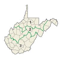
West Virginia's congressional districts
Encyclopedia
U.S. state
A U.S. state is any one of the 50 federated states of the United States of America that share sovereignty with the federal government. Because of this shared sovereignty, an American is a citizen both of the federal entity and of his or her state of domicile. Four states use the official title of...
of West Virginia
West Virginia
West Virginia is a state in the Appalachian and Southeastern regions of the United States, bordered by Virginia to the southeast, Kentucky to the southwest, Ohio to the northwest, Pennsylvania to the northeast and Maryland to the east...
currently has three congressional districts.
District 1
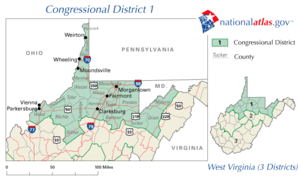
The 1st district encompasses the counties of Barbour
Barbour County, West Virginia
As of the census of 2000, there are 15,557 people, 6,123 households, and 4,365 families residing in the county. The population density is 46 people per square mile . There are 7,348 housing units at an average density of 22 per square mile...
, Brooke
Brooke County, West Virginia
As of the census of 2000, there were 25,447 people, 10,396 households, and 7,152 families residing in the county. The population density was 286 people per square mile . There were 11,150 housing units at an average density of 126 per square mile...
, Doddridge
Doddridge County, West Virginia
As of the census of 2000, there were 7,403 people, 2,845 households, and 2,102 families residing in the county. The population density was 23 people per square mile . There were 3,661 housing units at an average density of 11 per square mile...
, Gilmer
Gilmer County, West Virginia
As of the census of 2000, there were 7,160 people, 2,768 households, and 1,862 families residing in the county. The population density was 21 people per square mile . There were 3,621 housing units at an average density of 11 per square mile...
, Grant
Grant County, West Virginia
As of the census of 2000, there were 11,299 people, 4,591 households, and 3,273 families residing in the county. The population density was 24 people per square mile . There were 6,105 housing units at an average density of 13 per square mile...
, Hancock
Hancock County, West Virginia
As of the census of 2000, there were 32,667 people, 13,678 households, and 9,506 families residing in the county. The population density was 394 people per square mile . There were 14,728 housing units at an average density of 178 per square mile...
, Harrison
Harrison County, West Virginia
As of the census of 2000, there were 68,652 people, 27,867 households, and 19,088 families residing in the county. The population density was 165 people per square mile . There were 31,112 housing units at an average density of 75 per square mile...
, Marion
Marion County, West Virginia
| style="float:right;"|As of the census of 2000, there were 56,598 people, 23,652 households, and 15,515 families residing in the county. The population density was 183 people per square mile . There were 26,660 housing units at an average density of 86 per square mile...
, Marshall
Marshall County, West Virginia
As of the census of 2000, there were 35,519 people, 14,207 households, and 10,101 families residing in the county. The population density was 116 people per square mile . There were 15,814 housing units at an average density of 52 per square mile...
, Mineral
Mineral County, West Virginia
Mineral County is a county located in the U.S. state of West Virginia. It is part of the Cumberland, MD-WV Metropolitan Statistical Area. As of 2010, the population was 28,212. Its county seat is Keyser.-Ancient history:...
, Monongalia
Monongalia County, West Virginia
As of the census of 2000, there were 81,866 people, 33,446 households, and 18,495 families residing in the county. The population density was 227 people per square mile . There were 36,695 housing units at an average density of 102 per square mile...
, Ohio
Ohio County, West Virginia
As of the census of 2000, there were 47,427 people, 19,733 households, and 12,155 families residing in the county. The population density was 447 people per square mile . There were 22,166 housing units at an average density of 209 per square mile...
, Pleasants
Pleasants County, West Virginia
As of the census of 2000, there were 7,514 people, 2,887 households, and 2,136 families residing in the county. The population density was 58 people per square mile . There were 3,214 housing units at an average density of 25 per square mile...
, Preston
Preston County, West Virginia
As of the census of 2000, there were 29,334 people, 11,544 households, and 8,357 families residing in the county. The population density was 45 people per square mile . There were 13,444 housing units at an average density of 21 per square mile...
, Ritchie
Ritchie County, West Virginia
As of the census of 2000, there were 10,343 people, 4,184 households, and 2,999 families residing in the county. The population density was 23 people per square mile . There were 5,513 housing units at an average density of 12 per square mile...
, Taylor
Taylor County, West Virginia
As of the census of 2000, there were 16,089 people, 6,320 households, and 4,487 families residing in the county. The population density was 93 people per square mile . There were 7,125 housing units at an average density of 41 per square mile...
, Tucker
Tucker County, West Virginia
As of the census of 2000, there were 7,321 people, 3,052 households, and 2,121 families residing in the county. The population density was 18 people per square mile . There were 4,634 housing units at an average density of 11 per square mile...
, Tyler, Wetzel
Wetzel County, West Virginia
As of the census of 2000, there were 17,693 people, 7,164 households, and 5,079 families residing in the county. The population density was 49 people per square mile . There were 8,313 housing units at an average density of 23 per square mile...
, and Wood
Wood County, West Virginia
As of the census of 2000, there were 87,986 people, 36,275 households, and 24,884 families residing in the county. The population density was 240 people per square mile . There were 39,785 housing units at an average density of 108 per square mile...
. The district's population in the 2010 Census did not change relative to the other 2 districts and it will thus carry over unchanged for the next 10 year cycle.
The 1st district is represented by Republican
Republican Party (United States)
The Republican Party is one of the two major contemporary political parties in the United States, along with the Democratic Party. Founded by anti-slavery expansion activists in 1854, it is often called the GOP . The party's platform generally reflects American conservatism in the U.S...
Congressman David McKinley
David McKinley
David B. McKinley is the U.S. Representative for . He is a member of the Republican Party. He is a former member of the West Virginia House of Delegates and Chairman of the West Virginia Republican Party....
.
District 2
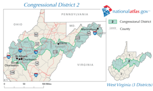
The 2nd district currently encompasses the counties of Berkeley
Berkeley County, West Virginia
Berkeley County is a county located in the Eastern Panhandle region of the U.S. state of West Virginia. As of 2010, the population is 104,169, making it the second-most populous county in West Virginia, behind Kanawha...
, Braxton, Calhoun
Calhoun County, West Virginia
As of the census of 2000, there were 7,582 people, 3,071 households, and 2,201 families residing in the county. The population density was 27 people per square mile . There were 3,848 housing units at an average density of 14 per square mile...
, Clay
Clay County, West Virginia
-External links:***...
, Hampshire
Hampshire County, West Virginia
Hampshire County is a county located in the U.S. state of West Virginia. As of 2010, the population was 23,964. Its county seat is Romney, West Virginia's oldest town . Hampshire County was created by the Virginia General Assembly on December 13, 1753, from parts of Frederick and Augusta counties ...
, Hardy
Hardy County, West Virginia
As of the census of 2000, there were 12,669 people, 5,204 households, and 3,564 families residing in the county. The population density was 22 people per square mile . There were 7,115 housing units at an average density of 12 per square mile...
, Jackson, Jefferson
Jefferson County, West Virginia
Jefferson County is a county located in the U.S. state of West Virginia. As of 2010, the population was 53,498. Its county seat is Charles Town...
, Kanawha
Kanawha County, West Virginia
As of the census of 2000, there were 200,073 people, 86,226 households, and 55,960 families residing in the county. The population density was 222 people per square mile . There were 93,788 housing units at an average density of 104 per square mile...
, Lewis
Lewis County, West Virginia
As of the census of 2000, there were 16,919 people, 6,946 households, and 4,806 families residing in the county. The population density was 44 people per square mile . There were 7,944 housing units at an average density of 21 per square mile...
, Mason
Mason County, West Virginia
As of the census of 2000, there were 25,957 people, 10,587 households, and 7,569 families residing in the county. The population density was 60 people per square mile . There were 12,056 housing units at an average density of 28 per square mile...
, Morgan
Morgan County, West Virginia
Morgan County is a county located in the U.S. state of West Virginia. As of 2010, it's population was 17,541. Its county seat is Berkeley Springs. The county is one of three in Hagerstown-Martinsburg, MD-WV Metropolitan Statistical Area...
, Pendleton
Pendleton County, West Virginia
As of the census of 2000, there were 8,196 people, 3,350 households, and 2,355 families residing in the county. The population density was 12 people per square mile . There were 5,102 housing units at an average density of 7 per square mile...
, Putnam
Putnam County, West Virginia
As of the census of 2000, there were 51,589 people, 20,028 households, and 15,281 families residing in the county. The population density was 149 people per square mile . There were 21,621 housing units at an average density of 62 per square mile...
, Randolph
Randolph County, West Virginia
As of the census of 2000, there were 28,262 people, 11,072 households, and 7,661 families residing in the county. The population density was 27 people per square mile . There were 13,478 housing units at an average density of 13 per square mile...
, Roane
Roane County, West Virginia
As of the census of 2000, there were 15,446 people, 6,161 households, and 4,479 families residing in the county. The population density was 32 people per square mile . There were 7,360 housing units at an average density of 15 per square mile...
, Upshur
Upshur County, West Virginia
As of the census of 2000, there were 23,404 people, 8,972 households, and 6,352 families residing in the county. The population density was 66 people per square mile . There were 10,751 housing units at an average density of 30 per square mile...
, and Wirt
Wirt County, West Virginia
As of the census of 2000, there were 5,873 people, 2,284 households, and 1,699 families residing in the county. The population density was 25 people per square mile . There were 3,266 housing units at an average density of 14 per square mile...
. The district grew in population in the 2010 Census and thus Mason County
Mason County, West Virginia
As of the census of 2000, there were 25,957 people, 10,587 households, and 7,569 families residing in the county. The population density was 60 people per square mile . There were 12,056 housing units at an average density of 28 per square mile...
will transfer to the 3rd District beginning with the next general election.
The 2nd district is represented by Republican
Republican Party (United States)
The Republican Party is one of the two major contemporary political parties in the United States, along with the Democratic Party. Founded by anti-slavery expansion activists in 1854, it is often called the GOP . The party's platform generally reflects American conservatism in the U.S...
Congresswoman Shelley Moore Capito
Shelley Moore Capito
Shelley Moore Capito is the U.S. Representative for , serving since 2001. She is a member of the Republican Party...
.
District 3
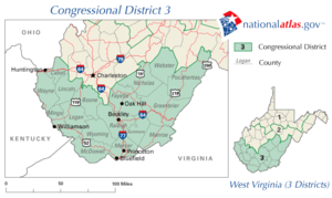
The 3rd district encompasses the counties of Boone
Boone County, West Virginia
As of the census of 2000, there were 25,535 people, 10,291 households, and 7,460 families residing in the county. The population density was 51 people per square mile . There were 11,575 housing units at an average density of 23 per square mile...
, Cabell
Cabell County, West Virginia
As of the census of 2000, there were 96,784 people, 41,180 households, and 25,490 families residing in the county. The population density was 344 people per square mile . There were 45,615 housing units at an average density of 162 per square mile...
, Fayette
Fayette County, West Virginia
As of the census of 2000, there were 47,579 people, 18,945 households, and 13,128 families residing in the county. The population density was 72 people per square mile . There were 21,616 housing units at an average density of 33 per square mile...
, Greenbrier
Greenbrier County, West Virginia
As of the census of 2000, there were 34,453 people, 14,571 households, and 9,922 families residing in the county. The population density was 34 people per square mile . There were 17,644 housing units at an average density of 17 per square mile...
, Lincoln
Lincoln County, West Virginia
As of the census of 2000, there were 22,108 people, 8,664 households, and 6,532 families residing in the county. The population density was 50 people per square mile . There were 9,846 housing units at an average density of 22 per square mile...
, Logan
Logan County, West Virginia
As of the census of 2000, there were 37,710 people, 14,880 households, and 10,936 families residing in the county. The population density was 83 people per square mile . There were 16,807 housing units at an average density of 37 per square mile...
, McDowell
McDowell County, West Virginia
McDowell County is a county in the U.S. state of West Virginia. The land that became McDowell was originally part of Tazewell County, Virginia. As of the 2010 census, the population was 22,113. Its county seat is Welch. McDowell county is the southern-most county in the state, geographically...
, Mercer
Mercer County, West Virginia
-External links:* * * * * * *...
, Mingo
Mingo County, West Virginia
As of the census of 2000, there were 28,253 people, 11,303 households, and 8,217 families residing in the county. The population density was 67 people per square mile . There were 12,898 housing units at an average density of 30 per square mile...
, Monroe
Monroe County, West Virginia
As of the census of 2000, there were 14,583 people, 5,447 households, and 3,883 families residing in the county. The population density was 31 people per square mile . There were 7,267 housing units at an average density of 15 per square mile...
, Nicholas, Pocahontas
Pocahontas County, West Virginia
As of the census of 2000, there were 9,131 people, 835 households, and 527 families residing in the county. The population density was 10 people per square mile . There were 7,594 housing units at an average density of 8 per square mile...
, Raleigh
Raleigh County, West Virginia
As of the census of 2000, there were 79,220 people, 31,793 households, and 22,096 families residing in the county. The population density was 130 people per square mile . There were 35,678 housing units at an average density of 59 per square mile...
, Summers
Summers County, West Virginia
Summers County is a county located in the U.S. state of West Virginia. As of the 2010 census, the population was 13,927. Its county seat is Hinton. Summers County was created by an act of the West Virginia General Assembly on February 27, 1871 from parts of Fayette, Greenbrier, Mercer and Monroe...
, Wayne
Wayne County, West Virginia
As of the census of 2000, there were 42,903 people, 17,239 households, and 12,653 families residing in the county. The population density was 85 people per square mile . There were 19,107 housing units at an average density of 38 per square mile...
, Webster, and Wyoming
Wyoming County, West Virginia
Wyoming County is a county located in the U.S. state of West Virginia. As of the 2010 census, the population was 23,796. Its county seat is Pineville. Wyoming County was created in 1850 from Logan County and named for the Delaware Indian word meaning "large plains."-Geography:According to the U.S...
. The district lost population in the 2010 Census and will thus add Mason County
Mason County, West Virginia
As of the census of 2000, there were 25,957 people, 10,587 households, and 7,569 families residing in the county. The population density was 60 people per square mile . There were 12,056 housing units at an average density of 28 per square mile...
beginning with the next general election.
The 3rd district is represented by Democratic
Democratic Party (United States)
The Democratic Party is one of two major contemporary political parties in the United States, along with the Republican Party. The party's socially liberal and progressive platform is largely considered center-left in the U.S. political spectrum. The party has the lengthiest record of continuous...
Congressman Nick Rahall
Nick Rahall
Nick Joe Rahall II is the U.S. Representative for West Virginia's 3rd congressional district, serving since 1977. Rahall is currently Ranking Member of the House Resources Committee. He is a member of the Democratic Party. The district includes much of the southern portion of the state, including...
.
District 4
See main article atThe 4th district was eliminated by the 1990 United States Census.
District 5
See main article atThe 5th district was eliminated by the 1970 United States Census.
District 6
See main article atThe 6th district was eliminated by the 1960 United States Census.