
West Fork River
Encyclopedia
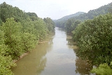
The West Fork River is a principal tributary
of the Monongahela River
, 103 miles (166 km) long, in north-central West Virginia
in the United States
. Via the Monongahela and Ohio
Rivers, it is part of the watershed
of the Mississippi River
, draining an area of 881 square miles (2,284 km²) on the unglaciated portion of the Allegheny Plateau
.
The river is formed near the community of Rock Cave
in southwestern Upshur County
by the confluence of small headwaters tributaries known as Straight Fork and Whites Camp Fork. From this confluence the West Fork River flows north through Lewis
, Harrison
and Marion
Counties, through the communities of Weston
, West Milford
, Clarksburg
, Lumberport
, Shinnston
, Enterprise
, Worthington
, and Monongah
to Fairmont
, where it joins the Tygart Valley River
from the west to form the Monongahela River. Among other tributaries, it collects Stonecoal Creek
in Weston; Hackers Creek
in southern Harrison County; Elk Creek
in Clarksburg; and Simpson Creek
and Tenmile Creek
in northern Harrison County.
The West Fork has a low gradient and is slow-moving throughout its course. It is locally popular for fishing
, and is stocked with muskellunge
by the West Virginia Division of Natural Resources. Other fish species in the river include carp
; channel
and flathead catfish
; golden
and rainbow trout
; largemouth
, smallmouth
, and spotted bass
; sauger
; and walleye
.
Jackson's Mill
was established along the river north of Weston around the year 1800 by Edward Jackson; his grandson, Thomas "Stonewall" Jackson
lived there during much of his youth. The site has been operated as a 4-H
facility since the 1920s.
A walking trail parallels the river for 1.2 miles (2 km) in River Bend City Park in Clarksburg. For much of its length between Clarksburg and Fairmont, the West Fork is paralleled by a pair of rail trail
s on the route of a mid-19th century line of the Baltimore and Ohio Railroad
. The Harrison County Trail extends northward from Clarksburg, and the West Fork River Trail connects Shinnston to Fairmont. A long-term closure of the connection between the two trails is anticipated, due to the presence of hazardous waste at an industrial site near the community of Spelter in northern Harrison County.
by commercial barge
traffic; it is classified by the West Virginia Division of Natural Resources
as "recreationally navigable" for canoe
s and similar craft. During the early history of the United States, the government of Virginia
attempted to maintain commercial navigability on the river, chartering a company for that purpose in 1793 and requiring that dam
s for milling
operations provide a chute for boats to pass downstream. Construction of a system of locks
, dams, and chutes was begun by the Monongahela Navigation Company in 1817; the project was abandoned following damage by flood
s in 1824.
Three miles (5 km) south of Weston, the river is dam
med by the U.S. Army Corps of Engineers to form Stonewall Jackson Lake
. The project was authorized by the federal Flood Control Act of 1966 for flood control, improvement of water quality
and water supply
, improvement of habitat for fish and wildlife, hydropower
, and recreation. Construction of the dam was delayed by the opposition of local residents and began in the mid-1980s at an ultimate cost of $208 million; it became fully operational in 1988. The dam is 95 feet (29 m) tall and forms a 2650 acres (1,072.4 ha) lake, with a larger capacity during periods of flood. Land along the lake is leased as a wildlife management area and Stonewall Jackson Lake State Park
.
Between the years of 1905 and 1931, four small dams were constructed by the Clarksburg Water Board on a sixteen-mile (26 km) stretch of the river upstream (south) of Clarksburg, for the provision of local drinking water. While the dams in later years have come to be regarded as good fishing areas, the Water Board is working with the U.S. Fish and Wildlife Service on plans to remove them.
settled on "West Fork River" as the stream's name in 1902. According to the Geographic Names Information System
, the West Fork River has also been known historically as:
Tributary
A tributary or affluent is a stream or river that flows into a main stem river or a lake. A tributary does not flow directly into a sea or ocean...
of the Monongahela River
Monongahela River
The Monongahela River is a river on the Allegheny Plateau in north-central West Virginia and southwestern Pennsylvania in the United States...
, 103 miles (166 km) long, in north-central West Virginia
West Virginia
West Virginia is a state in the Appalachian and Southeastern regions of the United States, bordered by Virginia to the southeast, Kentucky to the southwest, Ohio to the northwest, Pennsylvania to the northeast and Maryland to the east...
in the United States
United States
The United States of America is a federal constitutional republic comprising fifty states and a federal district...
. Via the Monongahela and Ohio
Ohio River
The Ohio River is the largest tributary, by volume, of the Mississippi River. At the confluence, the Ohio is even bigger than the Mississippi and, thus, is hydrologically the main stream of the whole river system, including the Allegheny River further upstream...
Rivers, it is part of the watershed
Drainage basin
A drainage basin is an extent or an area of land where surface water from rain and melting snow or ice converges to a single point, usually the exit of the basin, where the waters join another waterbody, such as a river, lake, reservoir, estuary, wetland, sea, or ocean...
of the Mississippi River
Mississippi River
The Mississippi River is the largest river system in North America. Flowing entirely in the United States, this river rises in western Minnesota and meanders slowly southwards for to the Mississippi River Delta at the Gulf of Mexico. With its many tributaries, the Mississippi's watershed drains...
, draining an area of 881 square miles (2,284 km²) on the unglaciated portion of the Allegheny Plateau
Allegheny Plateau
The Allegheny Plateau is a large dissected plateau area in western and central New York, northern and western Pennsylvania, northern and western West Virginia, and eastern Ohio...
.
The river is formed near the community of Rock Cave
Rock Cave, West Virginia
Rock Cave is an unincorporated community in Upshur County, West Virginia, United States. The town is located southwest of Buckhannon at the junction of West Virginia Route 4 with County Routes 11/2 and 20/28....
in southwestern Upshur County
Upshur County, West Virginia
As of the census of 2000, there were 23,404 people, 8,972 households, and 6,352 families residing in the county. The population density was 66 people per square mile . There were 10,751 housing units at an average density of 30 per square mile...
by the confluence of small headwaters tributaries known as Straight Fork and Whites Camp Fork. From this confluence the West Fork River flows north through Lewis
Lewis County, West Virginia
As of the census of 2000, there were 16,919 people, 6,946 households, and 4,806 families residing in the county. The population density was 44 people per square mile . There were 7,944 housing units at an average density of 21 per square mile...
, Harrison
Harrison County, West Virginia
As of the census of 2000, there were 68,652 people, 27,867 households, and 19,088 families residing in the county. The population density was 165 people per square mile . There were 31,112 housing units at an average density of 75 per square mile...
and Marion
Marion County, West Virginia
| style="float:right;"|As of the census of 2000, there were 56,598 people, 23,652 households, and 15,515 families residing in the county. The population density was 183 people per square mile . There were 26,660 housing units at an average density of 86 per square mile...
Counties, through the communities of Weston
Weston, West Virginia
Weston is a city in Lewis County, West Virginia, United States. The population was 4,317 at the 2000 census. It is the county seat of Lewis County, and home to the West Virginia Museum of American Glass.-History:...
, West Milford
West Milford, West Virginia
West Milford is a town in Harrison County, West Virginia, United States. The population was 651 at the 2000 census.-Geography:West Milford is located at , along the West Fork River....
, Clarksburg
Clarksburg, West Virginia
Clarksburg is a city in and the county seat of Harrison County, West Virginia, United States, in the north-central region of the state. It is the principal city of the Clarksburg, WV Micropolitan Statistical Area...
, Lumberport
Lumberport, West Virginia
Lumberport is a town in Harrison County, West Virginia, United States. The population was 937 at the 2000 census.-Geography:Lumberport is located at , at the confluence of Tenmile Creek and the West Fork River....
, Shinnston
Shinnston, West Virginia
Shinnston is a city in Harrison County, West Virginia, United States, along the West Fork River. The population was 2,295 at the 2000 census.-Geography:Shinnston is located at ....
, Enterprise
Enterprise, West Virginia
Enterprise is a census-designated place in Harrison County, West Virginia, United States, along the West Fork River. The population was 961 at the 2010 census.-Geography:Enterprise is located at ....
, Worthington
Worthington, West Virginia
Worthington is a town in Marion County, West Virginia, in the United States. The population was 170 at the 2000 census. Worthington was incorporated in 1893 and named for Colonel George Worthington, an early settler.-Geography:...
, and Monongah
Monongah, West Virginia
Monongah is a town in Marion County, West Virginia along the West Fork River. The population was 939 at the 2000 census. Monongah was incorporated in 1891 by Circuit Court...
to Fairmont
Fairmont, West Virginia
Fairmont is a city in Marion County, West Virginia, United States. Nicknamed "The Friendly City". The population was 18,704 at the 2010 census...
, where it joins the Tygart Valley River
Tygart Valley River
The Tygart Valley River — also known as the Tygart River — is a principal tributary of the Monongahela River, approximately long, in east-central West Virginia, USA...
from the west to form the Monongahela River. Among other tributaries, it collects Stonecoal Creek
Stonecoal Creek
Stonecoal Creek is a tributary of the West Fork River, long, in north-central West Virginia in the United States. Via the West Fork, Monongahela and Ohio Rivers, it is part of the watershed of the Mississippi River, draining an area of on the unglaciated portion of the Allegheny Plateau...
in Weston; Hackers Creek
Hackers Creek
Hackers Creek is a tributary of the West Fork River, long, in north-central West Virginia in the United States. Via the West Fork, Monongahela and Ohio Rivers, it is part of the watershed of the Mississippi River, draining an area of on the unglaciated portion of the Allegheny Plateau...
in southern Harrison County; Elk Creek
Elk Creek (West Virginia)
Elk Creek is a tributary of the West Fork River, long, in north-central West Virginia in the United States. Via the West Fork, Monongahela and Ohio Rivers, it is part of the watershed of the Mississippi River, draining an area of on the unglaciated portion of the Allegheny Plateau...
in Clarksburg; and Simpson Creek
Simpson Creek
Simpson Creek is a tributary of the West Fork River, long, in north-central West Virginia in the United States. Via the West Fork, Monongahela and Ohio Rivers, it is part of the watershed of the Mississippi River, draining an area of on the unglaciated portion of the Allegheny Plateau...
and Tenmile Creek
Tenmile Creek (West Virginia)
Tenmile Creek is a tributary of the West Fork River, long, in north-central West Virginia in the United States. Via the West Fork, Monongahela and Ohio Rivers, it is part of the watershed of the Mississippi River, draining an area of on the unglaciated portion of the Allegheny Plateau.Tenmile...
in northern Harrison County.
The West Fork has a low gradient and is slow-moving throughout its course. It is locally popular for fishing
Fishing
Fishing is the activity of trying to catch wild fish. Fish are normally caught in the wild. Techniques for catching fish include hand gathering, spearing, netting, angling and trapping....
, and is stocked with muskellunge
Muskellunge
A muskellunge , also known as a muskelunge, muscallonge, milliganong, or maskinonge , is a large, relatively uncommon freshwater fish of North America. Muskellunge are the largest member of the pike family, Esocidae...
by the West Virginia Division of Natural Resources. Other fish species in the river include carp
Carp
Carp are various species of oily freshwater fish of the family Cyprinidae, a very large group of fish native to Europe and Asia. The cypriniformes are traditionally grouped with the Characiformes, Siluriformes and Gymnotiformes to create the superorder Ostariophysi, since these groups have certain...
; channel
Channel catfish
Channel catfish, Ictalurus punctatus, is North America's most numerous catfish species. It is the official fish of Missouri, Iowa, Nebraska, Kansas, and Tennessee, and is informally referred to as a "channel cat". In the United States they are the most fished catfish species with approximately 8...
and flathead catfish
Flathead catfish
The flathead catfish , also called the yellow cat, opelousas, and shovelhead cat, are large North American freshwater catfish. This is the only species of the genus Pylodictis...
; golden
Golden Trout
The golden trout is a sub-species of the rainbow trout, and it closley resembles the juvenile Rainbow trout. The fish is also known as the California golden trout and is native to Golden Trout Creek, Volcano Creek and the South Fork Kern River. Another variant, O. m...
and rainbow trout
Rainbow trout
The rainbow trout is a species of salmonid native to tributaries of the Pacific Ocean in Asia and North America. The steelhead is a sea run rainbow trout usually returning to freshwater to spawn after 2 to 3 years at sea. In other words, rainbow trout and steelhead trout are the same species....
; largemouth
Largemouth bass
The largemouth bass is a species of black bass in the sunfish family native to North America . It is also known as widemouth bass, bigmouth, black bass, bucketmouth, Potter's fish, Florida bass, Florida largemouth, green bass, green trout, linesides, Oswego bass, southern largemouth...
, smallmouth
Smallmouth bass
The smallmouth bass is a species of freshwater fish in the sunfish family of the order Perciformes. It is the type species of its genus...
, and spotted bass
Spotted bass
The Spotted Bass , also called "Spotty", "Leeman", or "Spots" in various fishing communities, is a species of freshwater fish sunfish family of order Perciformes. One of the black basses, it is native to the Mississippi River basin and across theGulf States, from central Texas through the Florida...
; sauger
Sauger
The sauger is a freshwater perciform fish of the family Percidae which resembles its close relative the walleye. They are members of the largest vertebrate order, Perciforms. They are the most migratory percid species in North America. Saugers obtain two dorsal fins, the first is spiny and the...
; and walleye
Walleye
Walleye is a freshwater perciform fish native to most of Canada and to the northern United States. It is a North American close relative of the European pikeperch...
.
Jackson's Mill
Jackson's Mill
Jackson's Mill was a grist mill in West Virginia . The center of the Jackson estate stood in the peninsula formed by the confluence of Freeman's Creek and the West Fork River...
was established along the river north of Weston around the year 1800 by Edward Jackson; his grandson, Thomas "Stonewall" Jackson
Stonewall Jackson
ຄຽשת״ׇׂׂׂׂ֣|birth_place= Clarksburg, Virginia |death_place=Guinea Station, Virginia|placeofburial=Stonewall Jackson Memorial CemeteryLexington, Virginia|placeofburial_label= Place of burial|image=...
lived there during much of his youth. The site has been operated as a 4-H
4-H
4-H in the United States is a youth organization administered by the National Institute of Food and Agriculture of the United States Department of Agriculture , with the mission of "engaging youth to reach their fullest potential while advancing the field of youth development." The name represents...
facility since the 1920s.
A walking trail parallels the river for 1.2 miles (2 km) in River Bend City Park in Clarksburg. For much of its length between Clarksburg and Fairmont, the West Fork is paralleled by a pair of rail trail
Rail trail
A rail trail is the conversion of a disused railway easement into a multi-use path, typically for walking, cycling and sometimes horse riding. The characteristics of former tracks—flat, long, frequently running through historical areas—are appealing for various development. The term sometimes also...
s on the route of a mid-19th century line of the Baltimore and Ohio Railroad
Baltimore and Ohio Railroad
The Baltimore and Ohio Railroad was one of the oldest railroads in the United States and the first common carrier railroad. It came into being mostly because the city of Baltimore wanted to compete with the newly constructed Erie Canal and another canal being proposed by Pennsylvania, which...
. The Harrison County Trail extends northward from Clarksburg, and the West Fork River Trail connects Shinnston to Fairmont. A long-term closure of the connection between the two trails is anticipated, due to the presence of hazardous waste at an industrial site near the community of Spelter in northern Harrison County.
Dams and navigation
The West Fork River is not navigableNavigability
A body of water, such as a river, canal or lake, is navigable if it is deep, wide and slow enough for a vessel to pass. Preferably there are few obstructions such as rocks or trees to avoid. Bridges must have sufficient clearance. High water speed may make a channel unnavigable. Waters may be...
by commercial barge
Barge
A barge is a flat-bottomed boat, built mainly for river and canal transport of heavy goods. Some barges are not self-propelled and need to be towed by tugboats or pushed by towboats...
traffic; it is classified by the West Virginia Division of Natural Resources
West Virginia Division of Natural Resources
The West Virginia Division of Natural Resources is an agency of the government of the U.S. state of West Virginia. While formerly known as the cabinet-level Department of Natural Resources, it is now part of the West Virginia Department of Commerce...
as "recreationally navigable" for canoe
Canoe
A canoe or Canadian canoe is a small narrow boat, typically human-powered, though it may also be powered by sails or small electric or gas motors. Canoes are usually pointed at both bow and stern and are normally open on top, but can be decked over A canoe (North American English) or Canadian...
s and similar craft. During the early history of the United States, the government of Virginia
Virginia
The Commonwealth of Virginia , is a U.S. state on the Atlantic Coast of the Southern United States. Virginia is nicknamed the "Old Dominion" and sometimes the "Mother of Presidents" after the eight U.S. presidents born there...
attempted to maintain commercial navigability on the river, chartering a company for that purpose in 1793 and requiring that dam
Dam
A dam is a barrier that impounds water or underground streams. Dams generally serve the primary purpose of retaining water, while other structures such as floodgates or levees are used to manage or prevent water flow into specific land regions. Hydropower and pumped-storage hydroelectricity are...
s for milling
Watermill
A watermill is a structure that uses a water wheel or turbine to drive a mechanical process such as flour, lumber or textile production, or metal shaping .- History :...
operations provide a chute for boats to pass downstream. Construction of a system of locks
Lock (water transport)
A lock is a device for raising and lowering boats between stretches of water of different levels on river and canal waterways. The distinguishing feature of a lock is a fixed chamber in which the water level can be varied; whereas in a caisson lock, a boat lift, or on a canal inclined plane, it is...
, dams, and chutes was begun by the Monongahela Navigation Company in 1817; the project was abandoned following damage by flood
Flood
A flood is an overflow of an expanse of water that submerges land. The EU Floods directive defines a flood as a temporary covering by water of land not normally covered by water...
s in 1824.
Three miles (5 km) south of Weston, the river is dam
Dam
A dam is a barrier that impounds water or underground streams. Dams generally serve the primary purpose of retaining water, while other structures such as floodgates or levees are used to manage or prevent water flow into specific land regions. Hydropower and pumped-storage hydroelectricity are...
med by the U.S. Army Corps of Engineers to form Stonewall Jackson Lake
Stonewall Jackson Lake
Stonewall Jackson Lake is an impoundment on the West Fork River in Lewis County, West Virginia. The lake is a flood control project of the Pittsburgh District of the United States Army Corps of Engineers. Stonewall Resort is located along the lake's shore...
. The project was authorized by the federal Flood Control Act of 1966 for flood control, improvement of water quality
Water quality
Water quality is the physical, chemical and biological characteristics of water. It is a measure of the condition of water relative to the requirements of one or more biotic species and or to any human need or purpose. It is most frequently used by reference to a set of standards against which...
and water supply
Water supply
Water supply is the provision of water by public utilities, commercial organisations, community endeavours or by individuals, usually via a system of pumps and pipes...
, improvement of habitat for fish and wildlife, hydropower
Hydropower
Hydropower, hydraulic power, hydrokinetic power or water power is power that is derived from the force or energy of falling water, which may be harnessed for useful purposes. Since ancient times, hydropower has been used for irrigation and the operation of various mechanical devices, such as...
, and recreation. Construction of the dam was delayed by the opposition of local residents and began in the mid-1980s at an ultimate cost of $208 million; it became fully operational in 1988. The dam is 95 feet (29 m) tall and forms a 2650 acres (1,072.4 ha) lake, with a larger capacity during periods of flood. Land along the lake is leased as a wildlife management area and Stonewall Jackson Lake State Park
Stonewall Jackson Lake State Park
Stonewall Jackson Lake State Park is a state park along the shores of Stonewall Jackson Lake, an impoundment on the West Fork River in the U.S. state of West Virginia. The lake is a project of the United States Army Corps of Engineers. The original park was completed in 1990 and consisted of a...
.
Between the years of 1905 and 1931, four small dams were constructed by the Clarksburg Water Board on a sixteen-mile (26 km) stretch of the river upstream (south) of Clarksburg, for the provision of local drinking water. While the dams in later years have come to be regarded as good fishing areas, the Water Board is working with the U.S. Fish and Wildlife Service on plans to remove them.
Variant names
The United States Board on Geographic NamesUnited States Board on Geographic Names
The United States Board on Geographic Names is a United States federal body whose purpose is to establish and maintain uniform usage of geographic names throughout the U.S. government.-Overview:...
settled on "West Fork River" as the stream's name in 1902. According to the Geographic Names Information System
Geographic Names Information System
The Geographic Names Information System is a database that contains name and locative information about more than two million physical and cultural features located throughout the United States of America and its territories. It is a type of gazetteer...
, the West Fork River has also been known historically as:
- Muddy River
- West Branch
- West Fork
- West Fork Monongahela RiverMonongahela RiverThe Monongahela River is a river on the Allegheny Plateau in north-central West Virginia and southwestern Pennsylvania in the United States...
- West Fork of Monongahela River
- West River
See also
- List of West Virginia rivers
- Walkersville Covered BridgeWalkersville Covered BridgeWalkersville Covered Bridge is a historic covered bridge near Walkersville, Lewis County, West Virginia. It was built in 1903, and is a Queen post truss bridge measuring 12 feet, 1 1/2 inches wide and 39 feet, 4 inches long. It has red board-and-batten siding and a standing seam metal roof...