

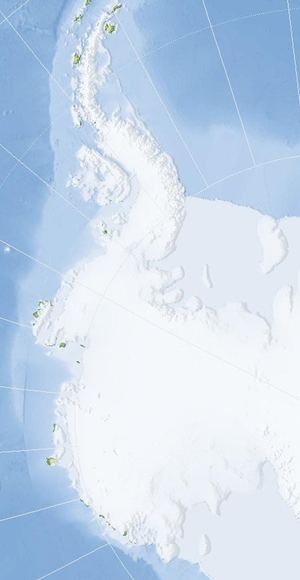
West Antarctica
Encyclopedia
Western Hemisphere
The Western Hemisphere or western hemisphere is mainly used as a geographical term for the half of the Earth that lies west of the Prime Meridian and east of the Antimeridian , the other half being called the Eastern Hemisphere.In this sense, the western hemisphere consists of the western portions...
including the Antarctic Peninsula
Antarctic Peninsula
The Antarctic Peninsula is the northernmost part of the mainland of Antarctica. It extends from a line between Cape Adams and a point on the mainland south of Eklund Islands....
.
Location and description
Lying on the Pacific OceanPacific Ocean
The Pacific Ocean is the largest of the Earth's oceanic divisions. It extends from the Arctic in the north to the Southern Ocean in the south, bounded by Asia and Australia in the west, and the Americas in the east.At 165.2 million square kilometres in area, this largest division of the World...
side of the Transantarctic Mountains
Transantarctic Mountains
The three largest mountain ranges on the Antarctic continent are the Transantarctic Mountains , the West Antarctica Ranges, and the East Antarctica Ranges. The Transantarctic Mountains compose a mountain range in Antarctica which extend, with some interruptions, across the continent from Cape Adare...
, West Antarctica comprises the Antarctic Peninsula
Antarctic Peninsula
The Antarctic Peninsula is the northernmost part of the mainland of Antarctica. It extends from a line between Cape Adams and a point on the mainland south of Eklund Islands....
(with Graham Land
Graham Land
Graham Land is that portion of the Antarctic Peninsula which lies north of a line joining Cape Jeremy and Cape Agassiz. This description of Graham Land is consistent with the 1964 agreement between the British Antarctic Place-names Committee and the US Advisory Committee on Antarctic Names, in...
and Palmer Land
Palmer Land
Palmer Land is that portion of the Antarctic Peninsula which lies south of a line joining Cape Jeremy and Cape Agassiz. This application of Palmer Land is consistent with the 1964 agreement between US-ACAN and UK-APC, in which the name Antarctic Peninsula was approved for the major peninsula of...
) and Ellsworth Land
Ellsworth Land
Ellsworth Land is that portion of the Antarctic continent bounded on the west by Marie Byrd Land, on the north by Bellingshausen Sea, on the northeast by the base of Antarctic Peninsula, and on the east by the western margin of Ronne Ice Shelf. It extends between 103°24'W and 79°45'W...
, Marie Byrd Land
Marie Byrd Land
Marie Byrd Land is the portion of West Antarctica lying east of the Ross Ice Shelf and the Ross Sea and south of the Pacific Ocean, extending eastward approximately to a line between the head of the Ross Ice Shelf and Eights Coast. It stretches between 158°W and 103°24'W...
and King Edward VII Land and offshore islands such as Adelaide Island
Adelaide Island
Adelaide Island or Isla Adelaida or Isla Belgrano is a large, mainly ice-covered island, long and wide, lying at the north side of Marguerite Bay off the west coast of the Antarctic Peninsula. The island lies within the Argentine, British and Chilean Antarctic claims, at .Adelaide Island was...
, the Filchner-Ronne Ice Shelf
Filchner-Ronne Ice Shelf
The Filchner-Ronne Ice Shelf, also known as Ronne-Filchner Ice Shelf, is an Antarctic ice shelf bordering the Weddell Sea.-Description:...
on the Weddell Sea
Weddell Sea
The Weddell Sea is part of the Southern Ocean and contains the Weddell Gyre. Its land boundaries are defined by the bay formed from the coasts of Coats Land and the Antarctic Peninsula. The easternmost point is Cape Norvegia at Princess Martha Coast, Queen Maud Land. To the east of Cape Norvegia is...
, and the Ross Ice Shelf
Ross Ice Shelf
The Ross Ice Shelf is the largest ice shelf of Antarctica . It is several hundred metres thick. The nearly vertical ice front to the open sea is more than 600 km long, and between 15 and 50 metres high above the water surface...
on the Ross Sea
Ross Sea
The Ross Sea is a deep bay of the Southern Ocean in Antarctica between Victoria Land and Marie Byrd Land.-Description:The Ross Sea was discovered by James Ross in 1841. In the west of the Ross Sea is Ross Island with the Mt. Erebus volcano, in the east Roosevelt Island. The southern part is covered...
. West Antarctica is separated from the main land mass of the continent by the icy waters of the Ross Sea and Weddell Sea, and resembles a giant peninsula
Peninsula
A peninsula is a piece of land that is bordered by water on three sides but connected to mainland. In many Germanic and Celtic languages and also in Baltic, Slavic and Hungarian, peninsulas are called "half-islands"....
that stretches roughly from the South Pole
South Pole
The South Pole, also known as the Geographic South Pole or Terrestrial South Pole, is one of the two points where the Earth's axis of rotation intersects its surface. It is the southernmost point on the surface of the Earth and lies on the opposite side of the Earth from the North Pole...
towards the southern tip of South America
South America
South America is a continent situated in the Western Hemisphere, mostly in the Southern Hemisphere, with a relatively small portion in the Northern Hemisphere. The continent is also considered a subcontinent of the Americas. It is bordered on the west by the Pacific Ocean and on the north and east...
.
The name has existed for more than 100 years (Balch, 1902; Nordenskiöld
Otto Nordenskiöld
Nils Otto Gustaf Nordenskjöld was a Finnish and Swedish geologist, geographer, and polar explorer.-Biography:...
, 1905), but its greatest use followed the International Geophysical Year
International Geophysical Year
The International Geophysical Year was an international scientific project that lasted from July 1, 1957, to December 31, 1958. It marked the end of a long period during the Cold War when scientific interchange between East and West was seriously interrupted...
(1957-58) and explorations disclosing that the Transantarctic Mountains provide a useful regional separation of West Antarctica and East Antarctica
East Antarctica
East Antarctica, also called Greater Antarctica, constitutes the majority of the Antarctic continent, lying on the Indian Ocean side of the Transantarctic Mountains...
. The name was approved by Advisory Committee on Antarctic Names
Advisory Committee on Antarctic Names
The Advisory Committee on Antarctic Names is an advisory committee of the United States Board on Geographic Names responsible for recommending names for features in Antarctica...
(US-ACAN) in 1962.
West Antarctica is mostly covered by a massive ice sheet referred to as the West Antarctic Ice Sheet
West Antarctic Ice Sheet
The West Antarctic Ice Sheet is the segment of the continental ice sheet that covers West Antarctica, the portion of Antarctica on the side of the Transantarctic Mountains which lies in the Western Hemisphere. The WAIS is classified as a marine-based ice sheet, meaning that its bed lies well...
(WAIS). This ice sheet
Ice sheet
An ice sheet is a mass of glacier ice that covers surrounding terrain and is greater than 50,000 km² , thus also known as continental glacier...
has shown signs of decreasing mass.
Marielandia Antarctic Tundra
The parts of West Antarctica not covered with ice (Antarctic oasisAntarctic oasis
An Antarctic oasis is a large area naturally free of snow and ice in the otherwise ice-covered continent of Antarctica.-Geology:In Antarctica there are, in addition to mountain tops and nunataks, other natural snow- and ice-free areas often referred to as "Antarctic oases" or "dry valleys"...
), which are the coasts of the Antarctic Peninsula
Antarctic Peninsula
The Antarctic Peninsula is the northernmost part of the mainland of Antarctica. It extends from a line between Cape Adams and a point on the mainland south of Eklund Islands....
, constitute a biodiversity
Biodiversity
Biodiversity is the degree of variation of life forms within a given ecosystem, biome, or an entire planet. Biodiversity is a measure of the health of ecosystems. Biodiversity is in part a function of climate. In terrestrial habitats, tropical regions are typically rich whereas polar regions...
region known as Marielandia Antarctic tundra
Tundra
In physical geography, tundra is a biome where the tree growth is hindered by low temperatures and short growing seasons. The term tundra comes through Russian тундра from the Kildin Sami word tūndâr "uplands," "treeless mountain tract." There are three types of tundra: Arctic tundra, alpine...
(after Marie Byrd Land
Marie Byrd Land
Marie Byrd Land is the portion of West Antarctica lying east of the Ross Ice Shelf and the Ross Sea and south of the Pacific Ocean, extending eastward approximately to a line between the head of the Ross Ice Shelf and Eights Coast. It stretches between 158°W and 103°24'W...
). This area has the mildest climate in Antarctica and the moss
Moss
Mosses are small, soft plants that are typically 1–10 cm tall, though some species are much larger. They commonly grow close together in clumps or mats in damp or shady locations. They do not have flowers or seeds, and their simple leaves cover the thin wiry stems...
and lichen
Lichen
Lichens are composite organisms consisting of a symbiotic organism composed of a fungus with a photosynthetic partner , usually either a green alga or cyanobacterium...
-covered rocks are free of snow during the summer months, although the weather is still intensely cold and the growing season very short.