
Wertheim am Main
Encyclopedia
Wertheim is a town in southwestern Germany
, in the state of Baden-Württemberg
with a population of 24,202. It is located on the confluence of the rivers Tauber
and Main.
It is known for its wine, castle and medieval town centre.
and the Spessart
to the north across the river Main.
Neighboring parishes
The following Cities and parishes border on Wertheim, listed clockwise starting at the east:
Holzkirchen
, Helmstadt
and Neubrunn
(all district Würzburg
, Bavaria
), Werbach
and Külsheim
(both district Main-Tauber-Kreis), Neunkirchen
(district Miltenberg
, Bavaria
), Freudenberg
(Main-Tauber-Kreis), Stadtprozelten
and Faulbach
(both district Miltenberg) and Hasloch
, Kreuzwertheim
and Triefenstein
(all district Main-Spessart
, Bavaria).
 Wertheim was founded between the 7th and 8th century, however the first settlement was a town called Kreutzwertheim on the right of the river Main. From the early 12th century onwards, a branch of the noble family of the Reginbodons called themselves after the town. After the family of the earls of Wertheim had built a castle on the left bank of the river Main, a settlement developed at the foot of this dominating structure that was called Wertheim. It was mentioned for the first time in 779. In 1192, it was referred to as "Suburbium castri Wertheim" and in 1200 the town is called “oppidium” and 1244 “civitas”.
Count
Eberhard of Wertheim reigned from the year 1355 to 1373. 1363 Emperor Karl IV granted him by degree the right to mint coins.
The last count of Wertheim was Michael III. He married the oldest daughter of the count Ludwig of Stolberg, Katharina. Michael died without producing a male heir and consequently the county passed on to Ludwig of Stolberg. 1574, after the death of Ludwig, the county was passed on to his son-in-law count Ludwig of Löwenstein
.
The town Wertheim developed into the center of the county of Wertheim. The county was governed by the house of Löwenstein-Wertheim
. In 1630 the house split into two lines: the older Protestant line Löwenstein-Wertheim-Virneburg and the catholic line Löwenstein-Wertheim-Rochefort.The county existed until 1806 when it was divided as a consequence of the Reichsdeputationshauptschluss ("Principal Conclusion of the Extraordinary Imperial Delegation"). The area left of the Main river was given to the Grand Duchy of Baden
, while the territories right of the Main, were given to the Kingdom of Bavaria
.
In 1938 Wertheim was merged with Tauberbischofsheim
into the new Landkreis Tauberbischofsheim.
From 1972 onwards 15 communities were incorporated with Wertheim. The 15 communities are Bettingen, Dertingen, Dietenhan, Dörlesberg, Grünenwört, Höhefeld, Kembach, Lindelbach, Mondfeld, Nassig, Reicholzheim, Sachsenhausen, Sonderriet, Urphar and Waldenhausen. As of January 1, 1973 the Landkreis Tauberbischofsheim was merged into the new Main-Tauber-Kreis.
Due to the incorporation of surrounding communities, Wertheim reached the 20,000 population mark in 1975.
Wertheim became a Große Kreisstadt
(district town) on January 1, 1976.
Established in 1406, the cemetery of the former Jewish community is one of the oldest in Germany. In use up until the 20th century, it is the oldest existing Jewish cemetery in Baden-Württemberg.
The coat of arms is nearly unchanged in use since 1556. It is the coat of arms of the earls of Wertheim, which resided in the Wertheim castle and which controlled a small area for centuries.The meaning of the symbols is unknown.
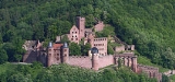
_-_10_-_360_panorama_der_stadt.jpg) The Burg Wertheim (castle) is the landmark of the town. Wertheim has a medieval town center with half-timbered houses and small streets. The Protestant church (Stiftskirche) has existed in Gothic style architecture since 1383. Two clocks can be seen on the clock tower, one with an hour hand only, for the residents of the castle. The Kilianskapelle is one of the finest examples of gothic-style chapels in Germany and was under construction from 1469 onwards. The Engelsbrunnen (Angels' well) from 1574 was built of the red sandstone typical of this area and derives its name from the two little angels which hold Wertheim’s coat of arms.
The Burg Wertheim (castle) is the landmark of the town. Wertheim has a medieval town center with half-timbered houses and small streets. The Protestant church (Stiftskirche) has existed in Gothic style architecture since 1383. Two clocks can be seen on the clock tower, one with an hour hand only, for the residents of the castle. The Kilianskapelle is one of the finest examples of gothic-style chapels in Germany and was under construction from 1469 onwards. The Engelsbrunnen (Angels' well) from 1574 was built of the red sandstone typical of this area and derives its name from the two little angels which hold Wertheim’s coat of arms.
Noteworthy also is the Kittsteintor with the flood markings from 1595 onwards and the Blaue Haus (Blue house) with the only known paint that uses blue glass fragments for the color.
A visit to the abbey Bronnbach founded in 1150 in the Tauber valley, is also recommended. Consecrated in 1222, the Basilica in the late-Romanesque
and early-Gothic style is one of the most important churches of a religious order in south Germany.
Wertheim has restored its lovely 1799 synagogue.
(France
), since 1964 - Huntingdon
and Godmanchester
(United Kingdom), since 1981 - Szentendre
(Hungary
), since 1989 - Csobánka
(Hungary
), since 1992 - Gubbio
(Italy
), since 2006
>
Year
Number of Residents
June 6.1961 ¹
11,329
May 27.1970 ¹
12,029
December 31.1975
20,942
December 31.1980
19,972
May 27.1987 ¹
20,377
December 31.1990
21,627
December 31.1995
24,432
December 31.2000
24,332
March 31. 2004
24,739
June 30. 2005
24,553
June 30. 2006
24,452
December 31.2006
24,302
June 30. 2007
24,202
¹ Census result
Germany
Germany , officially the Federal Republic of Germany , is a federal parliamentary republic in Europe. The country consists of 16 states while the capital and largest city is Berlin. Germany covers an area of 357,021 km2 and has a largely temperate seasonal climate...
, in the state of Baden-Württemberg
Baden-Württemberg
Baden-Württemberg is one of the 16 states of Germany. Baden-Württemberg is in the southwestern part of the country to the east of the Upper Rhine, and is the third largest in both area and population of Germany's sixteen states, with an area of and 10.7 million inhabitants...
with a population of 24,202. It is located on the confluence of the rivers Tauber
Tauber
For the singer, see Richard Tauber.For the mathematician, see Alfred Tauber.The Tauber is a river in Franconia, Germany. It is a left tributary of the Main and is 122 km in length...
and Main.
It is known for its wine, castle and medieval town centre.
Geography
Wertheim is the most northerly town in the state of Baden-Württemberg. It is situated on the delta of the river Tauber flowing into the river Main. It borders on the OdenwaldOdenwald
The Odenwald is a low mountain range in Hesse, Bavaria and Baden-Württemberg in Germany.- Location :The Odenwald lies between the Upper Rhine Rift Valley with the Bergstraße and the Hessisches Ried in the west, the Main and the Bauland in the east, the Hanau-Seligenstadt Basin – a subbasin of...
and the Spessart
Spessart
The Spessart is a low mountain range in northwestern Bavaria and southern Hesse, Germany. It is bordered on three sides by the Main River. The two most important towns located at the foot of the Spessart are Aschaffenburg and Würzburg....
to the north across the river Main.
Neighboring parishes
The following Cities and parishes border on Wertheim, listed clockwise starting at the east:
Holzkirchen
Holzkirchen
Holzkirchen is a market town in Bavaria, Germany. With a population of over 16,000 it is the largest town in the Miesbach district.Holzkirchen is located on the Alpenvorland in the county of Miesbach. It was established as a Markt in the 13th century....
, Helmstadt
Helmstadt
Helmstadt is a municipality in the district of Würzburg in Bavaria in Germany....
and Neubrunn
Neubrunn
Neubrunn is a municipality in the district of Würzburg in Bavaria, Germany....
(all district Würzburg
Würzburg
Würzburg is a city in the region of Franconia which lies in the northern tip of Bavaria, Germany. Located at the Main River, it is the capital of the Regierungsbezirk Lower Franconia. The regional dialect is Franconian....
, Bavaria
Bavaria
Bavaria, formally the Free State of Bavaria is a state of Germany, located in the southeast of Germany. With an area of , it is the largest state by area, forming almost 20% of the total land area of Germany...
), Werbach
Werbach
Werbach is a town in the district of Main-Tauber in Baden-Württemberg in Germany....
and Külsheim
Külsheim
Külsheim is a town in the Main-Tauber district, in Baden-Württemberg, Germany. It is situated 12 km northwest of Tauberbischofsheim, and 10 km south of Wertheim am Main.-Town districts :* Külsheim* Eiersheim...
(both district Main-Tauber-Kreis), Neunkirchen
Neunkirchen, Lower Franconia
Neunkirchen is a municipality in the Miltenberg district in the Regierungsbezirk of Lower Franconia in Bavaria, Germany and a member of the Verwaltungsgemeinschaft of Erftal, whose seat is in Bürgstadt....
(district Miltenberg
Miltenberg
Miltenberg is the seat of the like-named district in the Regierungsbezirk of Lower Franconia in Bavaria, Germany.- Location :...
, Bavaria
Bavaria
Bavaria, formally the Free State of Bavaria is a state of Germany, located in the southeast of Germany. With an area of , it is the largest state by area, forming almost 20% of the total land area of Germany...
), Freudenberg
Freudenberg am Main
Freudenberg am Main is a town and a municipality in the Main-Tauber district, in Baden-Württemberg, Germany. It is situated on the river Main, approx...
(Main-Tauber-Kreis), Stadtprozelten
Stadtprozelten
Stadtprozelten is a town in the Miltenberg district in the Regierungsbezirk of Lower Franconia in Bavaria, Germany and the seat of the Verwaltungsgemeinschaft of Stadtprozelten....
and Faulbach
Faulbach
Faulbach is a community in the Miltenberg district in the Regierungsbezirk of Lower Franconia in Bavaria, Germany.- Location :Faulbach lies in the Bavarian Lower Main Region....
(both district Miltenberg) and Hasloch
Hasloch
Hasloch is a community in the Main-Spessart district in the Regierungsbezirk of Lower Franconia in Bavaria, Germany and a member of the Verwaltungsgemeinschaft of Kreuzwertheim.-Location:...
, Kreuzwertheim
Kreuzwertheim
Kreuzwertheim is a market community in the Main-Spessart district in the Regierungsbezirk of Lower Franconia in Bavaria, Germany and the seat of the Verwaltungsgemeinschaft of Kreuzwertheim.- Location :...
and Triefenstein
Triefenstein
Triefenstein is a market community in the Main-Spessart district in the Regierungsbezirk of Lower Franconia in Bavaria, Germany.- Location :Triefenstein lies in the Würzburg Region....
(all district Main-Spessart
Main-Spessart
Main-Spessart is a district in Bavaria, Germany. It is bounded by the districts of Bad Kissingen, Schweinfurt and Würzburg, the state of Baden-Württemberg , the districts of Miltenberg and Aschaffenburg, and the state of Hesse .-History:The district was established in 1972 by merging the former...
, Bavaria).
History
Count
Count
A count or countess is an aristocratic nobleman in European countries. The word count came into English from the French comte, itself from Latin comes—in its accusative comitem—meaning "companion", and later "companion of the emperor, delegate of the emperor". The adjective form of the word is...
Eberhard of Wertheim reigned from the year 1355 to 1373. 1363 Emperor Karl IV granted him by degree the right to mint coins.
The last count of Wertheim was Michael III. He married the oldest daughter of the count Ludwig of Stolberg, Katharina. Michael died without producing a male heir and consequently the county passed on to Ludwig of Stolberg. 1574, after the death of Ludwig, the county was passed on to his son-in-law count Ludwig of Löwenstein
Löwenstein
Löwenstein is a town in the district of Heilbronn in Baden-Württemberg, Germany. It was first mentioned in 1123. The castle of Löwenstein served as a residence for the counts of Löwenstein-Wertheim. In 1634 the castle was destroyed by the imperial forces....
.
The town Wertheim developed into the center of the county of Wertheim. The county was governed by the house of Löwenstein-Wertheim
Löwenstein-Wertheim
Löwenstein-Wertheim was a county of the Holy Roman Empire, part of the Franconian Circle. It was formed from the counties of Löwenstein and Wertheim ....
. In 1630 the house split into two lines: the older Protestant line Löwenstein-Wertheim-Virneburg and the catholic line Löwenstein-Wertheim-Rochefort.The county existed until 1806 when it was divided as a consequence of the Reichsdeputationshauptschluss ("Principal Conclusion of the Extraordinary Imperial Delegation"). The area left of the Main river was given to the Grand Duchy of Baden
Grand Duchy of Baden
The Grand Duchy of Baden was a historical state in the southwest of Germany, on the east bank of the Rhine. It existed between 1806 and 1918.-History:...
, while the territories right of the Main, were given to the Kingdom of Bavaria
Kingdom of Bavaria
The Kingdom of Bavaria was a German state that existed from 1806 to 1918. The Bavarian Elector Maximilian IV Joseph of the House of Wittelsbach became the first King of Bavaria in 1806 as Maximilian I Joseph. The monarchy would remain held by the Wittelsbachs until the kingdom's dissolution in 1918...
.
In 1938 Wertheim was merged with Tauberbischofsheim
Tauberbischofsheim
Tauberbischofsheim is a German town in the north-east of Baden-Württemberg on the river Tauber with a population of about 13,000. It is the capital of the Main-Tauber district....
into the new Landkreis Tauberbischofsheim.
From 1972 onwards 15 communities were incorporated with Wertheim. The 15 communities are Bettingen, Dertingen, Dietenhan, Dörlesberg, Grünenwört, Höhefeld, Kembach, Lindelbach, Mondfeld, Nassig, Reicholzheim, Sachsenhausen, Sonderriet, Urphar and Waldenhausen. As of January 1, 1973 the Landkreis Tauberbischofsheim was merged into the new Main-Tauber-Kreis.
Due to the incorporation of surrounding communities, Wertheim reached the 20,000 population mark in 1975.
Wertheim became a Große Kreisstadt
Große Kreisstadt
Große Kreisstadt is a term in the German municipal law. In some German federal states the term is used as a special legal status for district-affiliated cities or towns with additional competences in comparison with other municipalities or towns of the district. The title is based on souvereign...
(district town) on January 1, 1976.
Established in 1406, the cemetery of the former Jewish community is one of the oldest in Germany. In use up until the 20th century, it is the oldest existing Jewish cemetery in Baden-Württemberg.
Coat of arms
The coat of arms of Wertheim, shows a parted shield the upper part in gold with a black eagle and below in blue three silver roses. The city flag is yellow-blue.The coat of arms is nearly unchanged in use since 1556. It is the coat of arms of the earls of Wertheim, which resided in the Wertheim castle and which controlled a small area for centuries.The meaning of the symbols is unknown.
Buildings
Noteworthy also is the Kittsteintor with the flood markings from 1595 onwards and the Blaue Haus (Blue house) with the only known paint that uses blue glass fragments for the color.
A visit to the abbey Bronnbach founded in 1150 in the Tauber valley, is also recommended. Consecrated in 1222, the Basilica in the late-Romanesque
Romanesque architecture
Romanesque architecture is an architectural style of Medieval Europe characterised by semi-circular arches. There is no consensus for the beginning date of the Romanesque architecture, with proposals ranging from the 6th to the 10th century. It developed in the 12th century into the Gothic style,...
and early-Gothic style is one of the most important churches of a religious order in south Germany.
Wertheim has restored its lovely 1799 synagogue.
Twin Cities
- Salon-de-ProvenceSalon-de-Provence
Salon-de-Provence is a commune in the Bouches-du-Rhône department in southern France. It is the location of an important air base.-History:Salon was a Gallo-Roman oppidum well positioned on the salt trade routes between Adriatic, Atlantic and Mediterranean seas, hence its name...
(France
France
The French Republic , The French Republic , The French Republic , (commonly known as France , is a unitary semi-presidential republic in Western Europe with several overseas territories and islands located on other continents and in the Indian, Pacific, and Atlantic oceans. Metropolitan France...
), since 1964 - Huntingdon
Huntingdon
Huntingdon is a market town in Cambridgeshire, England. The town was chartered by King John in 1205. It is the traditional county town of Huntingdonshire, and is currently the seat of the Huntingdonshire district council. It is known as the birthplace in 1599 of Oliver Cromwell.-History:Huntingdon...
and Godmanchester
Godmanchester
Godmanchester is a small town and civil parish within the Huntingdonshire district of Cambridgeshire, in England. It lies on the south bank of the River Great Ouse, south of the larger town of Huntingdon, and on the A14 road....
(United Kingdom), since 1981 - Szentendre
Szentendre
Szentendre is a riverside town in Pest county, Hungary, near the capital city Budapest. It is known for its museums , galleries, and artists. Due to its picturesque appearance and easy rail and river access, it has become a popular destination for tourists staying in Budapest...
(Hungary
Hungary
Hungary , officially the Republic of Hungary , is a landlocked country in Central Europe. It is situated in the Carpathian Basin and is bordered by Slovakia to the north, Ukraine and Romania to the east, Serbia and Croatia to the south, Slovenia to the southwest and Austria to the west. The...
), since 1989 - Csobánka
Csobánka
Csobánka is a village in Pest County, Budapest metropolitan area, Hungary. Csobánka is located in the Pilis Mountains which is a National Park in Hungary....
(Hungary
Hungary
Hungary , officially the Republic of Hungary , is a landlocked country in Central Europe. It is situated in the Carpathian Basin and is bordered by Slovakia to the north, Ukraine and Romania to the east, Serbia and Croatia to the south, Slovenia to the southwest and Austria to the west. The...
), since 1992 - Gubbio
Gubbio
Gubbio is a town and comune in the far northeastern part of the Italian province of Perugia . It is located on the lowest slope of Mt. Ingino, a small mountain of the Apennines. See also Mount Ingino Christmas Tree.-History:...
(Italy
Italy
Italy , officially the Italian Republic languages]] under the European Charter for Regional or Minority Languages. In each of these, Italy's official name is as follows:;;;;;;;;), is a unitary parliamentary republic in South-Central Europe. To the north it borders France, Switzerland, Austria and...
), since 2006
Population
| > | |
| Year | Number of Residents |
|---|---|
| 1617 | 3,670 |
| 1792 | 3,373 |
| 1810 | 3,154 |
| 1833 | 3,633 |
| December 1, 1871 | 3,328 |
| December 1, 1880 ¹ | 4,567 |
| December 1, 1890 ¹ | 3,535 |
| December 1, 1900 ¹ | 3,670 |
| December 1, 1910 ¹ | 3,648 |
| June 16. 1925 ¹ | 3,673 |
| June 16. 1933 ¹ | 3,679 |
| May 17. 1939 ¹ | 5,434 |
| December 1945 | 5,534 |
| September 13. 1950 ¹ | 9,789 |
¹ Census result
Mayor (Bürgermeister) and Lord Mayor (Oberbürgermeister)
- 1810-1827: Johann Christoph Schlundt
- 1827-1829: Christoph Michael Platz
- 1829-1832: Johann Georg Weimar
- 1832-1839: Johann Friedrich Bach
- 1839-1840: Christoph Wilhelm Müller
- 1840-1845: Johann Jakob von Runkel
- 1845-1852: Ludwig Haas
- 1852-1860: Johann Jakob von Runkel
- 1860-1866: Ludwig Haas
- 1866-1871: Philipp Frank
- 1871-1880: Lorenz Meyer
- 1880-1890: Philipp Amthauer
- 1890-1895: Philipp Mayer
- 1895-1905: Michael Müller
- 1905-1933: Hans Bardon
- 1933-1938: Friedrich Bender
- 1938-1943: Hans Mensler
- 1944-1945: Hermann Dürr
- 1945: Carl Roth
- 1945-1946: Michael Beck
- 1946: Otto Hoog
- 1946-1961: Carl Roth
- 1961-1981: Karl Josef Scheuermann
- 1981-2003: Stefan Gläser
- 2003-today: Stefan Mikulicz