
Wellington Urban Motorway
Encyclopedia
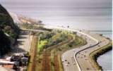
The Wellington Urban Motorway, part of SH 1, is the major road into and out of Wellington
, New Zealand
. It is 7 km long, ranges from three to six lanes wide, and extends from the base of the Ngauranga Gorge
into the Wellington CBD.
From the Ngauranga Interchange (State Highways 1 & 2), the motorway travels south across a narrow piece of land alongside the Wairarapa
and North Island Main Trunk railway lines. After passing through the suburb of Kaiwharawhara, the motorway travels across the 1335m long Thorndon overbridges, the longest bridges in the North Island
, before entering the suburb of Kelburn. Shortly after it enters the Terrace Tunnel
before terminating at Vivian Street in Wellington City.
History
The concept for the Wellington Urban Motorway first arose from the De Leuw Cather report on Wellington urban transport in 1963 which proposed a "foothills motorway" to be built from Ngauranga to the Mount Victoria Tunnel
. The alignment and scale of the motorway between Ngauranga and the Bowen Street overbridge as built very closely matches the original proposal, with the one exception that the proposed interchange at Ngaio Gorge (with on and off ramps over the railway to Kaiwharawhara) was never completed, although the stumps of a southbound on ramp and northbound on and off ramps remain visible today broadly parallel to Kaiwharawhara railway station. Beyond the Tinakori Road and Hawkestone Street on/off ramps going south, the motorway is a considerably scaled down concept from what was initially proposed.
The first phase of the motorway was opened between Ngauranga and Aotea Quay in 1969 as part of State Highway 2, relieving the chronically congested traffic signal controlled intersection at the base of the Ngauranga Gorge which endured peak time delays of several kilometres at AM and PM peaks. The motorway was extended in phases as far as Hawkestone Street/Tinakori Road by 1974. However, its last major extension was completed in 1978, with the construction of the Terrace Tunnel and the termination of the motorway at Ghuznee/Vivian Street.
The original concept was for 6 lanes to proceed to Willis Street, with the existing Terrace Tunnel being the northbound route, and a duplicate tunnel southbound. The current alignment of the motorway up to the Terrace offramp clearly shows how 6 lanes were quickly curtailed to three, by using the Terrace interchange to lose a lane each way, and a third lane merging southbound towards the remaining tunnel. About half of the southbound carriageway has been built but is unpaved, including the Bowen Street onramp which is now a walkway. The Shell Gully/Clifton Tce carpark under the motorway, accessible from the Terrace clearly shows the pillars, and part of the carriageway (now part of the carpark) that would have carried the additional three southbound lanes to the 2nd Terrace Tunnel. The northbound carriageway is almost complete with one exception, the Bowen Street offramp which would have been a counterclockwise loop splitting off from the Tinakori Road offramp. A section of the Tinakori Road offramp has a different type of barrier to the rest of the offramp, this shows where it would have been.
Funding for the second tunnel was indefinitely shelved in the 1970s due to fiscal pressures on government, and the beginning of far greater scrutiny of the quality of highway expenditure. It was clear that until the Wellington Urban Motorway was connected to State Highway 1 at Ngauranga Gorge, that a single Terrace Tunnel would be adequate for the traffic demands of the 1970s. With lack of future thinking, the tunnel is now a congestion blackspot in morning rush hour.
The Ngauranga Interchange connecting State Highway 1 opened in 1984, removing the State Highway designation from the Hutt Road south of Ngauranga, and making the Wellington Urban Motorway between Ngauranga and Aotea Quay both State Highway 1 and 2. While the Ngauranga Interchange relieved the severe congestion experienced at the traffic light controlled intersection at Ngauranga, it did double the usage of the rest of the motorway, generating peak time congestion at the end of the motorway, and in the AM peaks with merging traffic from the Hutt.
Meanwhile, the original plans to extend the motorway beyond Willis Street had been significantly reviewed, with a new plan for an "arterial extension" at a 70km/h standard proposed along the motorway alignment towards the existing Mount Victoria Tunnel (the original full motorway plan had been scrapped, as it would've meant the destruction of the Basin Reserve, and an unaffordable duplicate Mount Victoria Tunnel). This plan in itself had been shelved because the congestion levels did not warrant it, and the beginning of localised community opposition to the project.
Until 2006 the northbound motorway started at the Vivian Street onramp. On 28 December 2006 this onramp was closed, with a new northbound onramp at Karo Drive as part of the Wellington Inner City Bypass
.
Until 2007 the southbound motorway terminated at the Ghuznee Street offramp. On 25 March 2007 this offramp was closed, and traffic diverted to a new Vivian Street offramp along the line of the former onramp.
The Motorway is the subject of the ongoing Ngauranga to Airport Strategic Study, which is investigating Wellington City's future transport growth needs.
Interchanges
Wellington
Wellington is the capital city and third most populous urban area of New Zealand, although it is likely to have surpassed Christchurch due to the exodus following the Canterbury Earthquake. It is at the southwestern tip of the North Island, between Cook Strait and the Rimutaka Range...
, New Zealand
New Zealand
New Zealand is an island country in the south-western Pacific Ocean comprising two main landmasses and numerous smaller islands. The country is situated some east of Australia across the Tasman Sea, and roughly south of the Pacific island nations of New Caledonia, Fiji, and Tonga...
. It is 7 km long, ranges from three to six lanes wide, and extends from the base of the Ngauranga Gorge
Ngauranga Gorge
The Ngauranga Gorge is in the Wellington Region of New Zealand. State Highway 1 runs through the gorge, a vital link between Wellington City and the Kapiti Coast and the main route north out of Wellington. It is 2 kilometres long and has a grade of approximately 8%...
into the Wellington CBD.
From the Ngauranga Interchange (State Highways 1 & 2), the motorway travels south across a narrow piece of land alongside the Wairarapa
Wairarapa Line
The Wairarapa Line is a secondary railway line in the south-east of the North Island of New Zealand, connecting the capital city of Wellington with the Wairarapa region. The line ends at Woodville, where it joins the Palmerston North - Gisborne Line...
and North Island Main Trunk railway lines. After passing through the suburb of Kaiwharawhara, the motorway travels across the 1335m long Thorndon overbridges, the longest bridges in the North Island
North Island
The North Island is one of the two main islands of New Zealand, separated from the much less populous South Island by Cook Strait. The island is in area, making it the world's 14th-largest island...
, before entering the suburb of Kelburn. Shortly after it enters the Terrace Tunnel
Terrace Motorway Tunnel
The Terrace Tunnel takes the Wellington Urban Motorway under The Terrace in central Wellington, New Zealand. Opened in 1978, it is 460 metres in length.-Coordinates:* North portal: * South portal: -Design:...
before terminating at Vivian Street in Wellington City.
History
The concept for the Wellington Urban Motorway first arose from the De Leuw Cather report on Wellington urban transport in 1963 which proposed a "foothills motorway" to be built from Ngauranga to the Mount Victoria Tunnel
Mount Victoria Tunnel
The Mount Victoria Tunnel in the New Zealand capital city of Wellington is 623 metres long and 5 metres in height, connecting Hataitai to the centre of Wellington and the suburb of Mount Victoria, under the mount of the same name...
. The alignment and scale of the motorway between Ngauranga and the Bowen Street overbridge as built very closely matches the original proposal, with the one exception that the proposed interchange at Ngaio Gorge (with on and off ramps over the railway to Kaiwharawhara) was never completed, although the stumps of a southbound on ramp and northbound on and off ramps remain visible today broadly parallel to Kaiwharawhara railway station. Beyond the Tinakori Road and Hawkestone Street on/off ramps going south, the motorway is a considerably scaled down concept from what was initially proposed.
The first phase of the motorway was opened between Ngauranga and Aotea Quay in 1969 as part of State Highway 2, relieving the chronically congested traffic signal controlled intersection at the base of the Ngauranga Gorge which endured peak time delays of several kilometres at AM and PM peaks. The motorway was extended in phases as far as Hawkestone Street/Tinakori Road by 1974. However, its last major extension was completed in 1978, with the construction of the Terrace Tunnel and the termination of the motorway at Ghuznee/Vivian Street.
The original concept was for 6 lanes to proceed to Willis Street, with the existing Terrace Tunnel being the northbound route, and a duplicate tunnel southbound. The current alignment of the motorway up to the Terrace offramp clearly shows how 6 lanes were quickly curtailed to three, by using the Terrace interchange to lose a lane each way, and a third lane merging southbound towards the remaining tunnel. About half of the southbound carriageway has been built but is unpaved, including the Bowen Street onramp which is now a walkway. The Shell Gully/Clifton Tce carpark under the motorway, accessible from the Terrace clearly shows the pillars, and part of the carriageway (now part of the carpark) that would have carried the additional three southbound lanes to the 2nd Terrace Tunnel. The northbound carriageway is almost complete with one exception, the Bowen Street offramp which would have been a counterclockwise loop splitting off from the Tinakori Road offramp. A section of the Tinakori Road offramp has a different type of barrier to the rest of the offramp, this shows where it would have been.
Funding for the second tunnel was indefinitely shelved in the 1970s due to fiscal pressures on government, and the beginning of far greater scrutiny of the quality of highway expenditure. It was clear that until the Wellington Urban Motorway was connected to State Highway 1 at Ngauranga Gorge, that a single Terrace Tunnel would be adequate for the traffic demands of the 1970s. With lack of future thinking, the tunnel is now a congestion blackspot in morning rush hour.
The Ngauranga Interchange connecting State Highway 1 opened in 1984, removing the State Highway designation from the Hutt Road south of Ngauranga, and making the Wellington Urban Motorway between Ngauranga and Aotea Quay both State Highway 1 and 2. While the Ngauranga Interchange relieved the severe congestion experienced at the traffic light controlled intersection at Ngauranga, it did double the usage of the rest of the motorway, generating peak time congestion at the end of the motorway, and in the AM peaks with merging traffic from the Hutt.
Meanwhile, the original plans to extend the motorway beyond Willis Street had been significantly reviewed, with a new plan for an "arterial extension" at a 70km/h standard proposed along the motorway alignment towards the existing Mount Victoria Tunnel (the original full motorway plan had been scrapped, as it would've meant the destruction of the Basin Reserve, and an unaffordable duplicate Mount Victoria Tunnel). This plan in itself had been shelved because the congestion levels did not warrant it, and the beginning of localised community opposition to the project.
Until 2006 the northbound motorway started at the Vivian Street onramp. On 28 December 2006 this onramp was closed, with a new northbound onramp at Karo Drive as part of the Wellington Inner City Bypass
Wellington Inner City Bypass
The Wellington Inner City Bypass is a westbound one-way road varying from two to four lanes largely at ground level in central Wellington, New Zealand, part of State Highway 1, and was opened in March 2007....
.
Until 2007 the southbound motorway terminated at the Ghuznee Street offramp. On 25 March 2007 this offramp was closed, and traffic diverted to a new Vivian Street offramp along the line of the former onramp.
The Motorway is the subject of the ongoing Ngauranga to Airport Strategic Study, which is investigating Wellington City's future transport growth needs.
Interchanges
| Territorial authority | Location | km | Destinations | Notes |
|---|---|---|---|---|
| Wellington City Wellington City Wellington City Council is a territorial authority in the Wellington region of New Zealand. Wellington city extends as far north as Linden, and includes the rural areas of Makara and Ohariu. It is New Zealand's third-largest city, behind Auckland and Christchurch.Wellington attained city status in... |
Ngauranga | 1068.0 |  SH 1 Centennial Highway – Porirua SH 1 Centennial Highway – PoriruaPorirua Porirua is a city in the Wellington Region of New Zealand, immediately north of the city of Wellington, with their central business districts 20 km apart. A large proportion of the population commutes to Wellington, so it may be considered a satellite city. It almost completely surrounds... , Palmerston North Palmerston North Palmerston North is the main city of the Manawatu-Wanganui region of the North Island of New Zealand. It is an inland city with a population of and is the country's seventh largest city and eighth largest urban area. Palmerston North is located in the eastern Manawatu Plains near the north bank... |
Wellington Urban Motorway begins |
 SH 2 SH 2New Zealand State Highway 2 State Highway 2 is one of New Zealand's eight national highways. With the exception of State Highway 1, which runs the length of both of the country's main islands, SH 2 is the longest highway in the North Island... Hutt Road Hutt Valley Expressway The Hutt Valley Expressway is a 20 km section of State Highway 2, running from the end of the Wellington Urban Motorway at the Ngauranga, near Wellington, past Lower Hutt, to the seagull intersection at Fergusson Drive and River Road... – Hutt Valley, Masterton Masterton Masterton is a large town and local government district in the Wellington Region of New Zealand. It is the largest town in the Wairarapa, a region separated from Wellington by the Rimutaka ranges... |
Northbound exit and southbound entrance | |||
| Thorndon | 1070.9 | Aotea Quay – Waterfront | Southbound exit and northbound entrance | |
| 1071.8 | Murphy Street – Thorndon | Southbound exit and northbound entrance | ||
| 1072.2 | Hawkestone Street – Karori | Southbound only | ||
| 1072.5 | Tinakori Street – Thorndon | Northbound only | ||
| Wellington CBD | The Terrace – Kelburn | Southbound exit and northbound entrance | ||
| 1074.0 | Terrace Motorway Tunnel Terrace Motorway Tunnel The Terrace Tunnel takes the Wellington Urban Motorway under The Terrace in central Wellington, New Zealand. Opened in 1978, it is 460 metres in length.-Coordinates:* North portal: * South portal: -Design:... |
|||
| Te Aro | 1075.0 | SH 1 Vivian Street Vivian Street Vivian Street is a mostly one-way arterial road in central Wellington, New Zealand. It forms a part of the country's State Highway 1 network.It has traditionally had a reputation as a red-light district, particularly in its western half... – Airport Wellington International Airport Wellington International Airport is an international airport located in the suburb of Rongotai in Wellington, the capital city of New Zealand. It is a secondary hub and focus city for Air New Zealand and its subsidiaries... , Seatoun |
Wellington Urban Motorway ends Northbound traffic enters motorway from Karo Drive, 300 m south of Vivian Street. |
|