
Wearhead
Encyclopedia
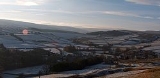
Wearhead is a village in County Durham
, in England
. It is situated at the top of Weardale
between Cowshill
and Ireshopeburn
. It is named after the nearby source of the River Wear
which runs eastwards for approx 40 miles to Sunderland.
The first settlement at Wearhead may have been a farmstead, possibly a summer base for the Bishop's cattle which would
have been taken to lower ground in winter. East of the village lies a steep hillside, which has evidence of shallow shafts and hushes which were the early methods used to extract lead and iron. In County Durham there were rich deposits of lead lying within a circle of about 10 miles radius drawn around Wearhead, hence the lead-mining industry of Weardale and Teesdale.
In 1858 the Post Office Directory listed - Beer Retailer, Grocer / Draper, Tailor / Draper, Grocer, Joiner / Postmaster, Grocer and Drapers / Joiner.
In 1915 the Post Office Directory listed - The Bank of Liverpool.
In 1971 Barclays Bank (formerly Martins Bank) was sold and the property became a Butcher shop, which has since closed.
Wearhead stands 1,104 feet above sea level and has some of the highest peaks in County Durham, Killhope Law (673m) and Burnhope Seat 2,452 feet (747 m). Burnhope Reservoir is approx 1 mile from Wearhead. In the construction six farms were submerged when water rose to fill the man-made reservoir in 1937.
, iron ore, lead ore and fluorspar to the industrial areas of North East England. It closed to passenger traffic in 1953 and later to freight in 1961.
Some signs of revival however in that the former Butchers Shop has re-opened as an independent village store & the former Post Office was opened as a Craft Shop/Cafe. But that has now been closed and it is for sale again.
Ullsfield Park is reputedly the highest football ground in use in England being at an elevation of 338 metres (1110 ft) above sea level.
A Mineral Valleys Project walk - Wearhead (The River Starts Here)
Killhope, The North of England lead Mining Museum
The Weardale Museum
County Durham
County Durham is a ceremonial county and unitary district in north east England. The county town is Durham. The largest settlement in the ceremonial county is the town of Darlington...
, in England
England
England is a country that is part of the United Kingdom. It shares land borders with Scotland to the north and Wales to the west; the Irish Sea is to the north west, the Celtic Sea to the south west, with the North Sea to the east and the English Channel to the south separating it from continental...
. It is situated at the top of Weardale
Weardale
Weardale is a dale, or valley, of the east side of the Pennines in County Durham, in England. Large parts of Weardale fall within the North Pennines Area of Outstanding Natural Beauty - the second largest AONB in England and Wales. The upper valley is surrounded by high fells and heather grouse...
between Cowshill
Cowshill
Cowshill is a village in County Durham, in England. It is situated at the top of Weardale, between Lanehead and Wearhead....
and Ireshopeburn
Ireshopeburn
Ireshopeburn is a village in County Durham, in England. It is situated on the south side of Weardale, between St John's Chapel and Wearhead, and on the other side of the Wear from West Blackdene and New Ho...
. It is named after the nearby source of the River Wear
River Wear
The River Wear is located in North East England, rising in the Pennines and flowing eastwards, mostly through County Durham, to the North Sea at Sunderland.-Geology and history:...
which runs eastwards for approx 40 miles to Sunderland.
The first settlement at Wearhead may have been a farmstead, possibly a summer base for the Bishop's cattle which would
have been taken to lower ground in winter. East of the village lies a steep hillside, which has evidence of shallow shafts and hushes which were the early methods used to extract lead and iron. In County Durham there were rich deposits of lead lying within a circle of about 10 miles radius drawn around Wearhead, hence the lead-mining industry of Weardale and Teesdale.
In 1858 the Post Office Directory listed - Beer Retailer, Grocer / Draper, Tailor / Draper, Grocer, Joiner / Postmaster, Grocer and Drapers / Joiner.
In 1915 the Post Office Directory listed - The Bank of Liverpool.
In 1971 Barclays Bank (formerly Martins Bank) was sold and the property became a Butcher shop, which has since closed.
Wearhead stands 1,104 feet above sea level and has some of the highest peaks in County Durham, Killhope Law (673m) and Burnhope Seat 2,452 feet (747 m). Burnhope Reservoir is approx 1 mile from Wearhead. In the construction six farms were submerged when water rose to fill the man-made reservoir in 1937.
Railways
Wearhead was the terminus of the Weardale Valley Extension Railway which opened in 1895, being mainly a freight line carrying limestoneLimestone
Limestone is a sedimentary rock composed largely of the minerals calcite and aragonite, which are different crystal forms of calcium carbonate . Many limestones are composed from skeletal fragments of marine organisms such as coral or foraminifera....
, iron ore, lead ore and fluorspar to the industrial areas of North East England. It closed to passenger traffic in 1953 and later to freight in 1961.
Decline then seeds of revival
In 2005 Wearhead lost its last shop with the closure of the Co-op and shortly afterwards, the Methodist Church held its last service after being in existence for over 179 years.Some signs of revival however in that the former Butchers Shop has re-opened as an independent village store & the former Post Office was opened as a Craft Shop/Cafe. But that has now been closed and it is for sale again.
Football
Wearhead United Football Club who play in the Second Division of the Crook & District League celebrated their Centenary in 2008 with 3 days of events including a fly over Ullsfield Park by the Red Arrows, and culminating in a sportsmans dinner with over 100 guests seated in a purpose made marquee on the field with guest of honour Eric Gates.Ullsfield Park is reputedly the highest football ground in use in England being at an elevation of 338 metres (1110 ft) above sea level.
Photos
Old photos of Wearhead 1900s to 1960sWhat to Do
Burnhope ReservoirA Mineral Valleys Project walk - Wearhead (The River Starts Here)
Killhope, The North of England lead Mining Museum
The Weardale Museum