

Weardale
Encyclopedia
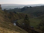
Valley
In geology, a valley or dale is a depression with predominant extent in one direction. A very deep river valley may be called a canyon or gorge.The terms U-shaped and V-shaped are descriptive terms of geography to characterize the form of valleys...
, of the east side of the Pennines
Pennines
The Pennines are a low-rising mountain range, separating the North West of England from Yorkshire and the North East.Often described as the "backbone of England", they form a more-or-less continuous range stretching from the Peak District in Derbyshire, around the northern and eastern edges of...
in County Durham
County Durham
County Durham is a ceremonial county and unitary district in north east England. The county town is Durham. The largest settlement in the ceremonial county is the town of Darlington...
, in England
England
England is a country that is part of the United Kingdom. It shares land borders with Scotland to the north and Wales to the west; the Irish Sea is to the north west, the Celtic Sea to the south west, with the North Sea to the east and the English Channel to the south separating it from continental...
. Large parts of Weardale fall within the North Pennines
North Pennines
The North Pennines is the northernmost section of the Pennine range of hills which runs north-south through northern England. It lies between Carlisle to the west and Darlington to the east...
Area of Outstanding Natural Beauty
Area of Outstanding Natural Beauty
An Area of Outstanding Natural Beauty is an area of countryside considered to have significant landscape value in England, Wales or Northern Ireland, that has been specially designated by the Countryside Agency on behalf of the United Kingdom government; the Countryside Council for Wales on...
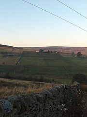
(AONB) - the second largest AONB in England and Wales. The upper valley is surrounded by high fell
Fell
“Fell” is a word used to refer to mountains, or certain types of mountainous landscape, in Scandinavia, the Isle of Man, and parts of northern England.- Etymology :...
s (up to 2454 feet (748 m) O.D. at Burnhope Seat
Burnhope Seat
Burnhope Seat is a moor in the North Pennines of England. It lies between the heads of the Rivers Tees, South Tyne and Wear. The summit is crossed by the boundary between County Durham and Cumbria...
) and heather grouse moors. The River Wear
River Wear
The River Wear is located in North East England, rising in the Pennines and flowing eastwards, mostly through County Durham, to the North Sea at Sunderland.-Geology and history:...
flows through Weardale before reaching Bishop Auckland
Bishop Auckland
Bishop Auckland is a market town and civil parish in County Durham in north east England. It is located about northwest of Darlington and southwest of Durham at the confluence of the River Wear with its tributary the River Gaunless...
and then Durham
Durham
Durham is a city in north east England. It is within the County Durham local government district, and is the county town of the larger ceremonial county...
, meeting the sea at Sunderland. Running roughly parallel to Weardale to the south is Teesdale
Teesdale
Teesdale is a dale, or valley, of the east side of the Pennines in England. Large parts of Teesdale fall within the North Pennines Area of Outstanding Natural Beauty - the second largest AONB in England and Wales. The River Tees rises below Cross Fell, the highest hill in the Pennines, and its...
. To the local people of Weardale, the area represents a part of English heritage and culture that is seldom encountered outside the sheltered valleys of the north of England. Walkers visiting Slit Wood in Westgate at the right time of year encounter several rare flowers.
The Wear Valley
Wear Valley
Wear Valley was, from 1974 to 2009, a local government district in County Durham, England. Its council was based in Crook.The district covered much of the Weardale area. In the west it was parished and rural, whereas in the east it was more urban...
local government district covered the upper part of the valley, including Weardale, between 1974 and 2009, when it was abolished on County Durham's becoming a unitary authority. (From 1894 to 1974 there was a Weardale Rural District
Weardale Rural District
Weardale was a rural district in County Durham, England from 1894 to 1974. It was formed under the Local Government Act 1894 as a successor to the Weardale rural sanitary district....
). Upper Weardale lies within the parliamentary constituency of North West Durham
North West Durham
North West Durham is a county constituency represented in the House of Commons of the Parliament of the United Kingdom. It elects one Member of Parliament by the first past the post system of election. It is considered to be a safe seat for the Labour Party; the majority of the electorate live in...
. The dale's principal settlements include St John's Chapel
St John's Chapel, County Durham
St John's Chapel is a village in County Durham, in England. It is situated in Weardale, on the south side of the River Wear on the A689 road between Daddry Shield and Ireshopeburn. The 2001 census reports a population of 307, of which only 43 are children under 16...
and the towns of Stanhope
Stanhope, County Durham
Stanhope is a small market town in County Durham, in England. It is situated on the River Wear between Eastgate and Frosterley on the north side of Weardale. The A689 trans-Pennine road meets the B6278 road from Barnard Castle to Shotley Bridge here....
and Wolsingham
Wolsingham
Wolsingham is a small market town in Weardale, County Durham, England. It is situated by the River Wear, between Crook and Stanhope in North West Durham.-History:Wolsingham sits at the confluence of the River Wear and Waskerley Beck...
.
Local climate
Historically, Weardale's winters have been typically harsh and prolonged with regular snow, now taken advantage of by skiers using a ski run at Swinhope Head.Wildlife and ecology
Wildlife includes an important population of Black GrouseBlack Grouse
The Black Grouse or Blackgame is a large bird in the grouse family. It is a sedentary species, breeding across northern Eurasia in moorland and bog areas near to woodland, mostly boreal...
, along with the more usual upland birds. Sea-trout
Brown trout
The brown trout and the sea trout are fish of the same species....
and salmon
Salmon
Salmon is the common name for several species of fish in the family Salmonidae. Several other fish in the same family are called trout; the difference is often said to be that salmon migrate and trout are resident, but this distinction does not strictly hold true...
run the River Wear while adder
Adder
Adder may refer to:Snakes:* Any of several groups of venomous snakes of the Viperidae family including Vipera berus, the common European adder, found in Europe and northern Asia...
s (snakes) are sometimes encountered on the moors. With regard to flora, some species-rich meadows remain, and the wood cranesbill (Geranium sylvaticum) and meadow cranesbill (G. pratense
Geranium pratense
Geranium pratense, the Meadow Cranesbill, is a species of plant in the Geraniaceae family. The leaves are deeply divided, divided into 7-9 lobes and 3-6 inch wide. It is native to much of Europe and Asia, but is cultivated and naturalized elsewhere.-References:*...
) are easy to spot in summer while the mountain pansy (Viola lutea
Viola lutea
Viola lutea , also known as Mountain Pansy, is a species in the genus Viola. It is native to Europe....
) is a characteristic plant of the shorter grass round the upper dale. The tiny but beautiful spring sandwort (Minuartia verna
Minuartia
Minuartia is a genus of small flowering plants, one of those commonly known as "sandwort" or "stitchwort". The genus is classed within the family Caryophyllaceae, the pink family, characterised by its opposite and decussate leaves....
) may be seen around old lead workings, enabled by its high tolerance of lead to colonise ground where contamination inhibits other species.
History and historical associations
Past occupation or activity by man is attested by evidence such as the Heatheryburn Bronze Age collection of gold and other objects, now in the British Museum; altars placed by Roman officers who took hunting trips out from forts in present-day County Durham; and the use from Norman times onwards of "Frosterley Marble", a black fossiliferous layer of limestone occurring near that village, as an ornamental material in Durham CathedralDurham Cathedral
The Cathedral Church of Christ, Blessed Mary the Virgin and St Cuthbert of Durham is a cathedral in the city of Durham, England, the seat of the Anglican Bishop of Durham. The Bishopric dates from 995, with the present cathedral being founded in AD 1093...
and many other churches and public buildings.
The small towns of Stanhope
Stanhope, County Durham
Stanhope is a small market town in County Durham, in England. It is situated on the River Wear between Eastgate and Frosterley on the north side of Weardale. The A689 trans-Pennine road meets the B6278 road from Barnard Castle to Shotley Bridge here....
and Wolsingham
Wolsingham
Wolsingham is a small market town in Weardale, County Durham, England. It is situated by the River Wear, between Crook and Stanhope in North West Durham.-History:Wolsingham sits at the confluence of the River Wear and Waskerley Beck...
appear to have existed as Anglo-Saxon settlements before the Norman Conquest of 1066. The Normans extended farming in this part of the dale, and later in the Middle Ages the upper dale was cleared for vaccaries - farms for pasturing cattle. The Bishops of Durham owned the mineral rights: the Church retained these throughout the effective life of the lead industry, miners and companies being lessees.
In 1327, Edward III
Edward III of England
Edward III was King of England from 1327 until his death and is noted for his military success. Restoring royal authority after the disastrous reign of his father, Edward II, Edward III went on to transform the Kingdom of England into one of the most formidable military powers in Europe...
led his first military campaign in Weardale. The so-called Weardale campaign against the Scots was a military failure but led to the politically important Treaty of Edinburgh-Northampton
Treaty of Edinburgh-Northampton
The Treaty of Edinburgh-Northampton was a peace treaty, signed in 1328 between the Kingdoms of England and Scotland. It brought an end to the First War of Scottish Independence, which had begun with the English invasion of Scotland in 1296...
. The campaign was graphically described by a participant, the chronicler Jean le Bel
Jean Le Bel
Jean Le Bel was a Medieval Flemish chronicler. His father, Gilles le Beal des Changes, was an alderman of Liege, where Jean himself was active....
.
In the 18th century John Wesley
John Wesley
John Wesley was a Church of England cleric and Christian theologian. Wesley is largely credited, along with his brother Charles Wesley, as founding the Methodist movement which began when he took to open-air preaching in a similar manner to George Whitefield...
visited the dale on a number of occasions ,and the valley became a Methodist stronghold. High House Chapel near Ireshopeburn has been claimed to be the Methodist chapel with the longest history of continuous use in the world, and contains the Weardale Museum (not to be confused with the Lead Mining Museum at Killhope) which includes a room devoted to Methodist and Wesley memorabilia.
As a youth between the World Wars the poet W. H. Auden
W. H. Auden
Wystan Hugh Auden , who published as W. H. Auden, was an Anglo-American poet,The first definition of "Anglo-American" in the OED is: "Of, belonging to, or involving both England and America." See also the definition "English in origin or birth, American by settlement or citizenship" in See also...
walked amid the wild countryside and the relics of the lead mining industry in and around Weardale and found these a lifelong source of inspiration. One place he visited, Rookhope
Rookhope
Rookhope is village in County Durham, in England. A former lead and fluorspar mining community, it first existed as a group of cattle farms in the 13th Century. It is situated in the Pennines to the north of Weardale. W. H...
, is also the setting of a ballad, "The Rookhope Ryde", which describes in some detail how in 1569 Weardale men drove out a party of cattle-raiders who had come down from the Roman Wall area .
Among contemporary works, Helen Cannam's "The Last Ballad" is a lively historical novel set in the dale in the early 19th century.
Mining history
Weardale was historically important for lead miningMining
Mining is the extraction of valuable minerals or other geological materials from the earth, from an ore body, vein or seam. The term also includes the removal of soil. Materials recovered by mining include base metals, precious metals, iron, uranium, coal, diamonds, limestone, oil shale, rock...
, and there is a lead
Lead
Lead is a main-group element in the carbon group with the symbol Pb and atomic number 82. Lead is a soft, malleable poor metal. It is also counted as one of the heavy metals. Metallic lead has a bluish-white color after being freshly cut, but it soon tarnishes to a dull grayish color when exposed...
mining museum
Museum
A museum is an institution that cares for a collection of artifacts and other objects of scientific, artistic, cultural, or historical importance and makes them available for public viewing through exhibits that may be permanent or temporary. Most large museums are located in major cities...
incorporating the preserved Park Level Mine at Killhope .
The first documented evidence of mining in the Northern Pennines dates from the 12th century, and records the presence of silver
Silver
Silver is a metallic chemical element with the chemical symbol Ag and atomic number 47. A soft, white, lustrous transition metal, it has the highest electrical conductivity of any element and the highest thermal conductivity of any metal...
mines in the areas of what are now Alston Moor, just west of Weardale, and Northumberland. Weardale was at this time a forested area and belonged to the Bishops of Durham, who used part of it as a hunting preserve. The villages of Eastgate and Westgate mark the former Eastern and Western entrances to this forest preserve (King, 1982).
Lead mining in Weardale reached its greatest levels during the 18th and 19th centuries, when the London Lead and Beaumont Companies dominated mining throughout the region. During the 1880s the declining prices for lead forced both companies to give up their leases in the area, though the Weardale Lead Company continued lead mining and smelting until 1931. According to Dunham (1990), 28 separate lead smelting operations were active in the region during the height of mining in the 19th century, but by 1919 the last major commercial mine had closed.
Not only lead, silver and fluorspar (see below) were extracted from Weardale. Large amounts of ironstone were taken especially from the Rookhope area during the Industrial Revolution to supply ironworks at Consett
Consett
Consett is a town in the northwest of County Durham, England, about southwest of Newcastle upon Tyne. It is home to 27,394 .Consett sits high on the edge of the Pennines. In 1841, it was a village community of only 145, but it was about to become a boom town: below the ground was coking coal and...
and other sites in County Durham. Local deposits of other minerals were also found on occasion. Ganister (hard sandstone) and dolerite (whinstone, basalt) have also been quarried in the past in Weardale.
The lead mining industry occasioned the coming and going of much of the population. Cornish miners, used to tin-mining, are one group who came to find similar work in the Pennine ore-field. Latter, many left Weardale for better-paid jobs in 19th century coal mines in the North-East, or emigrated to the New World.
A notable fluorospar
A major by-product of lead-mining was various crystals including the decorative coloured fluorspar (fluoriteFluorite
Fluorite is a halide mineral composed of calcium fluoride, CaF2. It is an isometric mineral with a cubic habit, though octahedral and more complex isometric forms are not uncommon...
), for which no industrial use was known till the later 19th century. Thereafter it was used in part of the steel-making process and also in the manufacture of non-stick frying pans, CFCs for aerosols, and other products. It is not a precious stone but fine samples are prized by collectors. The fluorite from this region, due to europium
Europium
Europium is a chemical element with the symbol Eu and atomic number 63. It is named after the continent of Europe. It is a moderately hard silvery metal which readily oxidizes in air and water...
impurities glows with a bluish light under ultraviolet excitation, and the characteristic glow of fluorospar samples from this region are responsible for the word fluorescence
Fluorescence
Fluorescence is the emission of light by a substance that has absorbed light or other electromagnetic radiation of a different wavelength. It is a form of luminescence. In most cases, emitted light has a longer wavelength, and therefore lower energy, than the absorbed radiation...
to describe that phenomenon.
At the North of England Lead Mining Museum at Killhope one can see a huge working water wheel, known as the Killhope Wheel.This was installed in the 1870s to power the crushing of grit in tanks in an adjacent building, so as to complete the separation of lead ore from worthless stone. The Museum also exhibits a fine collection of local minerals, as well as "spar boxes" - display cases made by miners to show crystal specimens they had themselves found.
Economy other than mining
After the closing of the lead mines, there were few sources of income for the local population left in the upper dale.In the lower dale round Stanhope and Frosterley, however, carboniferous limestone was quarried on a large scale from the 1840s, when rail links created with Teesside and Consett enabled it to be carried to these and other places for use in the iron and steel-making processes there. These places included Wolsingham in the lower dale, Tow Law on its fringes, and Witton Park further down the Wear valley. Of these, only a business at Tow Law now persists (2009) as a going concern.
Limestone quarrying continued into and beyond the 1960s, a relatively recent and large-scale development being the quarry serving the Blue Circle cement works near Eastgate, set up in the 1960s. This site has now been decommissioned and the major industry in Weardale is now cattle and sheep farming. Only one mine, The Rogerley Mine, is currently being prospected on a very small scale for mineral specimens.
Weardale had a railway reaching as far as Wearhead
Wearhead
Wearhead is a village in County Durham, in England. It is situated at the top of Weardale between Cowshill and Ireshopeburn. It is named after the nearby source of the River Wear which runs eastwards for approx 40 miles to Sunderland....
in three stages opened in 1847/1862/1895, but the section of the line above Eastgate closed between 1961 and 1968 in another series of three closures due to the decline of the lead industry. The remaining line was kept open by cement traffic and excursions until 1993, after which it was eventually taken over by the Weardale Railway
Weardale Railway
The Weardale Railway is a British single-track branch line railway providing regular daily passenger service between Bishop Auckland , Wolsingham, Frosterley and Stanhope. Services began on 23 May 2010 after a lapse of almost sixty years. The railway originally ran from Bishop Auckland to...
. Passenger services recommenced briefly in 2004, but in 2005 the project went into administration
Administration (insolvency)
As a legal concept, administration is a procedure under the insolvency laws of a number of common law jurisdictions. It functions as a rescue mechanism for insolvent entities and allows them to carry on running their business. The process – an alternative to liquidation – is often known as going...
. Trains began running again in 2006, under a new ownership structure. The line between Bishop Auckland
Bishop Auckland
Bishop Auckland is a market town and civil parish in County Durham in north east England. It is located about northwest of Darlington and southwest of Durham at the confluence of the River Wear with its tributary the River Gaunless...
and Wolsingham
Wolsingham
Wolsingham is a small market town in Weardale, County Durham, England. It is situated by the River Wear, between Crook and Stanhope in North West Durham.-History:Wolsingham sits at the confluence of the River Wear and Waskerley Beck...
was reopened in May 2010. Both heritage (steam and diesel loco hauled) and community (railbus) services are worked. During the first part of 2011 it is anticipated that coal traffic will start loaded at a new terminal in Wolsingham
Wolsingham
Wolsingham is a small market town in Weardale, County Durham, England. It is situated by the River Wear, between Crook and Stanhope in North West Durham.-History:Wolsingham sits at the confluence of the River Wear and Waskerley Beck...
. It will be trucked there from an opencast at nearby Tow Law. The connection to Network Rail has seen a number of through excursions during 2010 although for daily passenger traffic a separate platform called Bishop Auckland West is in use. It is on the site of the former West Junction when Bishop Auckland
Bishop Auckland
Bishop Auckland is a market town and civil parish in County Durham in north east England. It is located about northwest of Darlington and southwest of Durham at the confluence of the River Wear with its tributary the River Gaunless...
was a tri-angular station.
Currently there is a regular Monday to Saturday bus service provided by Weardale Motor Services from Bishop Auckland and Crook to Cowshill at the head of the dale; it may be possible at certain times of day to take the bus further on to the Killhope Lead Mining Museum, and to return by bus from it, at those times of the year when the latter is open.
There is a modest tourist industry, and inn/hotel, B&B and self-catering are among the types of accommodation available; there are some caravan sites. There are opportunities for pony-trekking and mountain biking, as well as much scope for the walker.