

Waterfalls of Ukraine
Encyclopedia
Ukraine
is the second-largest country in Europe
. Its various regions have diverse geographic features ranging from the highlands to the lowlands. A vast number of rivers run through the mountain ranges in Ukraine, with the Dnipro river traversing north to south and emptying into the Black Sea
. The snow melt from the mountains feeds the rivers, and natural changes in altitude form a sudden drop in elevation
and create many opportunities for waterfalls to form.
reach into Ukraine in the western part of the country. The highest peak is Hoverla
, which is 2061 m tall. Shipot is a famous waterfall where an annual festival is held with the same name, attracting thousands of tourists each year. The festival has taken place every year since 1993.
The Beskids
and Bieszczady Mountains
are also in western Ukraine. Kamianka waterfall
is part of Bieszczady Mountains in Lviv Oblast
.
landscape. The Zwinin
mountain together with the Stryi River
are part of this region.
Uchan-su
waterfall is part of the Crimean mountain range and a popular tourist attraction. It is located on the southern slopes of the Crimean Mountains close to the city of Yalta
. The Uchan-su
river begins at the foot of the Ai-Petri
Mountain and flows upstream the gorge. Then at a distance of 2 km (1 mi) from the source, it forms the Uchan-su waterfall, which is 98 metres (321.5 ft) high at an altitude of 390 metres (1,279.5 ft) and is most powerful during the spring when it is fed by snow melt from the mountains.
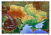 Most of Ukraine consists of regular plains with the average height above sea level
being 175 m. It is surrounded by mountains to the west and extreme south. Wide spaces of the country's plains are located in the south-western part of the East European Plain
. The plains have numerous highlands and lowlands caused by the uneven crystallized base of the East European craton
.
The highlands are characterized by Precambrian
basement rocks
from the Ukrainian Shield
. Ukraine's various highland regions include the Volyn-Podillia Upland and the Near-Dnipro Upland (on the right bank of Dnipro River) in the west, the south-western spurs of the Central Russian Uplands upon which runs the border with Russia in the east, and the Donets Ridge and the Near Azov Upland near the Sea of Azov
. The major lowlands are the Polissian Lowland in the north, the Black Sea Coastal Lowland in the south, and the Dnipro River Lowland that is located on the left bank of Dnipro River towards the north.
Ukraine
Ukraine is a country in Eastern Europe. It has an area of 603,628 km², making it the second largest contiguous country on the European continent, after Russia...
is the second-largest country in Europe
Europe
Europe is, by convention, one of the world's seven continents. Comprising the westernmost peninsula of Eurasia, Europe is generally 'divided' from Asia to its east by the watershed divides of the Ural and Caucasus Mountains, the Ural River, the Caspian and Black Seas, and the waterways connecting...
. Its various regions have diverse geographic features ranging from the highlands to the lowlands. A vast number of rivers run through the mountain ranges in Ukraine, with the Dnipro river traversing north to south and emptying into the Black Sea
Black Sea
The Black Sea is bounded by Europe, Anatolia and the Caucasus and is ultimately connected to the Atlantic Ocean via the Mediterranean and the Aegean seas and various straits. The Bosphorus strait connects it to the Sea of Marmara, and the strait of the Dardanelles connects that sea to the Aegean...
. The snow melt from the mountains feeds the rivers, and natural changes in altitude form a sudden drop in elevation
Elevation
The elevation of a geographic location is its height above a fixed reference point, most commonly a reference geoid, a mathematical model of the Earth's sea level as an equipotential gravitational surface ....
and create many opportunities for waterfalls to form.
Carpathian waterfalls
The Carpathian MountainsCarpathian Mountains
The Carpathian Mountains or Carpathians are a range of mountains forming an arc roughly long across Central and Eastern Europe, making them the second-longest mountain range in Europe...
reach into Ukraine in the western part of the country. The highest peak is Hoverla
Hoverla
Hoverla mountain at , is the highest mountain in Ukraine and part of the Carpathian Mountains. The mountain is located in the Eastern Beskides, in the so-called Chornohora region. The slopes are covered with beech and spruce forests, above which there is a belt of sub-alpine meadows called...
, which is 2061 m tall. Shipot is a famous waterfall where an annual festival is held with the same name, attracting thousands of tourists each year. The festival has taken place every year since 1993.
The Beskids
Beskids
The Beskids , ) is a traditional name for a series of Eastern European mountain ranges.- Definition :The Beskids are approximately 600 km in length and 50–70 km in width...
and Bieszczady Mountains
Bieszczady Mountains
Bieszczady is the Polish name for a mountain range in the extreme south-east of Poland, extending into Ukraine and Slovakia...
are also in western Ukraine. Kamianka waterfall
Kamianka-Buzka
Kamianka-Buzka is a city in the Lviv Oblast, of western Ukraine. It is the administrative center of the Kamianka-Buzkyi Raion . The city was previously known as Kamianka Strumilowa, and was a district city in Galicia...
is part of Bieszczady Mountains in Lviv Oblast
Lviv Oblast
Lviv Oblast is an oblast in western Ukraine. The administrative center of the oblast is the city of Lviv.-History:The oblast was created as part of the Ukrainian Soviet Socialist Republic on December 4, 1939...
.
Crimean waterfalls
In southern Ukraine, the Crimean Mountains on the western part of the range, drop steeply into the Black Sea. To the east, they change into a steppeSteppe
In physical geography, steppe is an ecoregion, in the montane grasslands and shrublands and temperate grasslands, savannas, and shrublands biomes, characterized by grassland plains without trees apart from those near rivers and lakes...
landscape. The Zwinin
Zwinin
The Zwinin is a mountain a few kilometers south of Stryi, Ukraine, in the Outer Eastern Carpathians.The peak is 992 meters above sea level and the ridge is 10 kilometers long...
mountain together with the Stryi River
Stryi River
The Stryi River starts in the Carpathian mountains in western Ukraine. It snakes through the mountains running for 144 miles . After 120 miles it passes Stryi...
are part of this region.
Uchan-su
Uchan-su (waterfall)
Uchan-su , is a waterfall on the river Uchan-su on the southern slopes of the Crimean Mountains. The name translates from the Crimean Tatar language for swift water....
waterfall is part of the Crimean mountain range and a popular tourist attraction. It is located on the southern slopes of the Crimean Mountains close to the city of Yalta
Yalta
Yalta is a city in Crimea, southern Ukraine, on the north coast of the Black Sea.The city is located on the site of an ancient Greek colony, said to have been founded by Greek sailors who were looking for a safe shore on which to land. It is situated on a deep bay facing south towards the Black...
. The Uchan-su
Uchan-su (river)
Uchan-su , is the river which flows in the South Coast of Crimea. The name translates from the Crimean Tatar language for 'swift water' .The river runs into the Black Sea in the center city of Yalta...
river begins at the foot of the Ai-Petri
Ai-Petri
Ai-Petri ; is a peak in the Crimean Mountains. For administrative purposes it is in the Yalta municipality of Crimea....
Mountain and flows upstream the gorge. Then at a distance of 2 km (1 mi) from the source, it forms the Uchan-su waterfall, which is 98 metres (321.5 ft) high at an altitude of 390 metres (1,279.5 ft) and is most powerful during the spring when it is fed by snow melt from the mountains.
Changes in elevation
Above mean sea level
The term above mean sea level refers to the elevation or altitude of any object, relative to the average sea level datum. AMSL is used extensively in radio by engineers to determine the coverage area a station will be able to reach...
being 175 m. It is surrounded by mountains to the west and extreme south. Wide spaces of the country's plains are located in the south-western part of the East European Plain
East European Plain
The East European Plain is a plain comprising a series of river basins in Eastern Europe. Together with the Northern European Plain it constitutes the European Plain. It is the largest mountain-free part of the European landscape.The plain spans approximately and averages about in elevation...
. The plains have numerous highlands and lowlands caused by the uneven crystallized base of the East European craton
East European craton
The East European craton is the core of the Baltica proto-plate and consists of three crustal regions/segments: Fennoscandia to the northwest, Volgo-Uralia to the east, and Sarmatia to the south...
.
The highlands are characterized by Precambrian
Precambrian
The Precambrian is the name which describes the large span of time in Earth's history before the current Phanerozoic Eon, and is a Supereon divided into several eons of the geologic time scale...
basement rocks
Basement (geology)
In geology, the terms basement and crystalline basement are used to define the rocks below a sedimentary platform or cover, or more generally any rock below sedimentary rocks or sedimentary basins that are metamorphic or igneous in origin...
from the Ukrainian Shield
Ukrainian shield
The Ukrainian Shield is the southwest shield of the East European craton. The Ukrainian Shield and the Voronezh Massif consist of 3.2-3.8 Ga Archaean crust in the southwest and east, and 2.3-2.1 Ga Early Proterozoic orogenic belts....
. Ukraine's various highland regions include the Volyn-Podillia Upland and the Near-Dnipro Upland (on the right bank of Dnipro River) in the west, the south-western spurs of the Central Russian Uplands upon which runs the border with Russia in the east, and the Donets Ridge and the Near Azov Upland near the Sea of Azov
Sea of Azov
The Sea of Azov , known in Classical Antiquity as Lake Maeotis, is a sea on the south of Eastern Europe. It is linked by the narrow Strait of Kerch to the Black Sea to the south and is bounded on the north by Ukraine mainland, on the east by Russia, and on the west by the Ukraine's Crimean...
. The major lowlands are the Polissian Lowland in the north, the Black Sea Coastal Lowland in the south, and the Dnipro River Lowland that is located on the left bank of Dnipro River towards the north.