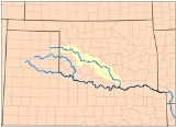
The
Washita River is a river in
TexasTexas is the second largest U.S. state by both area and population, and the largest state by area in the contiguous United States.The name, based on the Caddo word "Tejas" meaning "friends" or "allies", was applied by the Spanish to the Caddo themselves and to the region of their settlement in...
and
OklahomaOklahoma is a state located in the South Central region of the United States of America. With an estimated 3,751,351 residents as of the 2010 census and a land area of 68,667 square miles , Oklahoma is the 28th most populous and 20th-largest state...
,
United StatesThe United States of America is a federal constitutional republic comprising fifty states and a federal district...
. The river is 295 miles (474.8 km) long and terminates into
Lake TexomaLake Texoma is one of the largest reservoirs in the United States, the 12th largest Corps of Engineers lake, and the largest in USACE Tulsa District....
in
Johnston CountyJohnston County is a county located in the U.S. state of Oklahoma. As of 2000, the population was 10,513. Its county seat is Tishomingo.-Geography:...
(also
Bryan CountyBryan County is a county located in the U.S. state of Oklahoma. The population was 36,534 at the 2000 census. Its county seat is Durant. The county shares the same boundaries as the Durant Micropolitan Area. It is also home to the headquarters of the Choctaw Nation of Oklahoma located in Durant...
and
Marshall CountyMarshall County is a county located in the U.S. state of Oklahoma. As of 2000, the population was 13,184. Its county seat is Madill. The county's population grew at a rate of 35% in the 1990s and now it has a new population estimate at 20,000. Marshall County is the fastest growing county in...
- 33°55′N 96°35′W),
OklahomaOklahoma is a state located in the South Central region of the United States of America. With an estimated 3,751,351 residents as of the 2010 census and a land area of 68,667 square miles , Oklahoma is the 28th most populous and 20th-largest state...
and the
Red RiverThe Red River, or sometimes the Red River of the South, is a major tributary of the Mississippi and Atchafalaya Rivers in the southern United States of America. The river gains its name from the red-bed country of its watershed. It is one of several rivers with that name...
.
Geography
The Washita River crosses
Hemphill County, Texas and enters
OklahomaOklahoma is a state located in the South Central region of the United States of America. With an estimated 3,751,351 residents as of the 2010 census and a land area of 68,667 square miles , Oklahoma is the 28th most populous and 20th-largest state...
in
Roger Mills CountyRoger Mills County is a county located in the U.S. state of Oklahoma. As of 2000, the population was 3,436. Its county seat is Cheyenne.-History:Roger Mills County takes its name from Roger Q. Mills, a prominent American politician from Texas...
. In
OklahomaOklahoma is a state located in the South Central region of the United States of America. With an estimated 3,751,351 residents as of the 2010 census and a land area of 68,667 square miles , Oklahoma is the 28th most populous and 20th-largest state...
it cuts through the
Oklahoma Counties of:
Roger MillsRoger Mills County is a county located in the U.S. state of Oklahoma. As of 2000, the population was 3,436. Its county seat is Cheyenne.-History:Roger Mills County takes its name from Roger Q. Mills, a prominent American politician from Texas...
,
CusterCuster County is a county located in the U.S. state of Oklahoma. It was named in honor of General George Armstrong Custer. As of 2000, the population was 26,142. Its county seat is Arapaho.-Geography:...
,
WashitaWashita County is a county located in the U.S. state of Oklahoma. As of 2000, the population was 11,508. Its county seat is New Cordell. It was formerly located in Cloud Chief, Oklahoma....
,
CaddoCaddo County is a county located in the U.S. state of Oklahoma. As of 2000, the population was 30,150. Its county seat is Anadarko. It is named after the Caddo tribe who were settled here on the 1870s...
,
GradyGrady County is a county located in the U.S. state of Oklahoma. As of 2006, the population was 50,490. Its county seat is Chickasha.Grady County is part of the Oklahoma City Metropolitan Statistical Area.-History:...
,
GarvinGarvin County is a county located in the U.S. state of Oklahoma. As of 2000, the population was 27,210. Its county seat is Pauls Valley.-History:...
,
MurrayMurray County is a county located in the U.S. state of Oklahoma. As of 2000, the population was 12,623. Its county seat is Sulphur.-Geography:...
,
CarterCarter County is a county located in the U.S. state of Oklahoma. As of 2010, the population was 47,557. Its county seat is Ardmore.Carter County is part of the Ardmore, Oklahoma, Micropolitan Statistical Area.-Geography:According to the U.S...
, and
JohnstonJohnston County is a county located in the U.S. state of Oklahoma. As of 2000, the population was 10,513. Its county seat is Tishomingo.-Geography:...
. Lake Texoma is the border between
Bryan CountyBryan County is a county located in the U.S. state of Oklahoma. The population was 36,534 at the 2000 census. Its county seat is Durant. The county shares the same boundaries as the Durant Micropolitan Area. It is also home to the headquarters of the Choctaw Nation of Oklahoma located in Durant...
and
Marshall CountyMarshall County is a county located in the U.S. state of Oklahoma. As of 2000, the population was 13,184. Its county seat is Madill. The county's population grew at a rate of 35% in the 1990s and now it has a new population estimate at 20,000. Marshall County is the fastest growing county in...
.
The river bisects the heart of the
Anadarko BasinThe Anadarko Basin is a geologic depositional and structural basin centered in the western part of the state of Oklahoma and the Texas Panhandle, and extending into western Kansas and southeast Colorado.-Geology:...
, according to the USGS the Anadarko Basin is the fifth largest natural gas formation area discovered in the United States.
When the river reaches the
Arbuckle MountainsThe Arbuckle Mountains are an ancient mountain range in south-central Oklahoma in the United States. The granite rocks of the Arbuckles date back to the Proterozoic Era some 1.4 billion years ago which were overlain by sediments during the Paleozoic Era. The range reaches a height of 1,412 feet...
it drops 150 ft/mile (3%) as it cuts through a granite gorge.
The Washita's river bed is made up of unstable mud and sand. The banks of the river and steeply incised and erosive, made up of red earth. This makes it one of the most silt-laden streams in North America.
Source
The Washita River forms in eastern
Roberts County, Texas (35°38′N 100°36′W) near the town of
Miami, TexasMiami is a city in Roberts County, Texas, United States. It is part of the Pampa, Texas Micropolitan Statistical Area. The population was 588 at the 2000 census...
in the
Texas PanhandleThe Texas Panhandle is a region of the U.S. state of Texas consisting of the northernmost 26 counties in the state. The panhandle is a rectangular area bordered by New Mexico to the west and Oklahoma to the north and east...
.
Tributaries
Along its path, the Foss Reservoir dams the Washita River. Several reservoirs along the Washita River valley hold the waters of small tributaries, including
Fort Cobb LakeFort Cobb Reservoir is a reservoir located in Caddo County in the U.S. state of Oklahoma. It impounds the waters of Cobb Creek and Lake Creek. The lake covers approximately 4,000 acres of water and of shoreline. It was constructed in 1958...
, Lake Chickasha, and Arbuckle Reservoir.
History
The
Battle of Washita RiverThe Battle of Washita River occurred on November 27, 1868 when Lt. Col. George Armstrong Custer’s 7th U.S...
(or Battle of the Washita) occurred on November 27, 1868 when Lt. Col.
George Armstrong Custer George Armstrong Custer was a United States Army officer and cavalry commander in the American Civil War and the Indian Wars. Raised in Michigan and Ohio, Custer was admitted to West Point in 1858, where he graduated last in his class...
’s 7th U.S. Cavalry attacked
Black KettleChief Black Kettle was a leader of the Southern Cheyenne after 1854, who led efforts to resist American settlement from Kansas and Colorado territories. He was a peacemaker who accepted treaties to protect his people. He survived the Third Colorado Cavalry's Sand Creek Massacre on the Cheyenne...
’s
CheyenneCheyenne are a Native American people of the Great Plains, who are of the Algonquian language family. The Cheyenne Nation is composed of two united tribes, the Só'taeo'o and the Tsétsêhéstâhese .The Cheyenne are thought to have branched off other tribes of Algonquian stock inhabiting lands...
village on the Washita River (near present day
Cheyenne, OklahomaCheyenne is a town in Roger Mills County, Oklahoma, United States. The population was 801 at the 2010 census. It is the county seat of Roger Mills County.-History:...
) at dawn.
GeneralA general officer is an officer of high military rank, usually in the army, and in some nations, the air force. The term is widely used by many nations of the world, and when a country uses a different term, there is an equivalent title given....
(later
PresidentThe President of the United States of America is the head of state and head of government of the United States. The president leads the executive branch of the federal government and is the commander-in-chief of the United States Armed Forces....
)
Zachary TaylorZachary Taylor was the 12th President of the United States and an American military leader. Initially uninterested in politics, Taylor nonetheless ran as a Whig in the 1848 presidential election, defeating Lewis Cass...
established
Fort WashitaFort Washita is the former United States military post and National Historic Landmark located near Nida, Oklahoma on SH 199. Established in 1842 by General Zachary Taylor to protect citizens of the Choctaw and Chickasaw Nations from the plains indians it was later abandoned by Federal forces at...
near lower end of the river in 1842 to protect citizens of the
ChoctawThe Choctaw are a Native American people originally from the Southeastern United States...
and
ChickasawThe Chickasaw are Native American people originally from the region that would become the Southeastern United States...
Nations from the
plains indiansThe Plains Indians are the Indigenous peoples who live on the plains and rolling hills of the Great Plains of North America. Their colorful equestrian culture and resistance to White domination have made the Plains Indians an archetype in literature and art for American Indians everywhere.Plains...
. The Fort was about 19 miles above where the Washita river runs into the
Red RiverThe Red River, or sometimes the Red River of the South, is a major tributary of the Mississippi and Atchafalaya Rivers in the southern United States of America. The river gains its name from the red-bed country of its watershed. It is one of several rivers with that name...
.
External links