

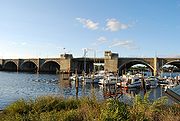
Washington Bridge (Providence)
Encyclopedia
Bridge
A bridge is a structure built to span physical obstacles such as a body of water, valley, or road, for the purpose of providing passage over the obstacle...
carrying Interstate 195
Interstate 195 (Rhode Island-Massachusetts)
Interstate 195 is an Interstate Highway running a combined 40.1 miles in the U.S. states of Massachusetts and Rhode Island. It travels from a junction with Interstate 95 in Providence, Rhode Island east to a junction with Interstate 495 and Route 25 in Wareham, Massachusetts...
over the Seekonk River
Seekonk River
The Seekonk River is a tidal extension of the Providence River in the U.S. state of Rhode Island. It flows approximately 8 km . Most historical scholars agree that the name is derived from two Native American words, sucki and honc...
from Providence
Providence, Rhode Island
Providence is the capital and most populous city of Rhode Island and was one of the first cities established in the United States. Located in Providence County, it is the third largest city in the New England region...
to East Providence, Rhode Island
East Providence, Rhode Island
East Providence is a city in Providence County, Rhode Island, United States. The population was 47,037 at the 2010 census, making it the fifth largest city in the state.-Geography:East Providence is located at ....
.
History
The original (southern) span was opened on September 25, 1930, as a bascule bridgeBascule bridge
A bascule bridge is a moveable bridge with a counterweight that continuously balances the span, or "leaf," throughout the entire upward swing in providing clearance for boat traffic....
, replacing an older swing bridge
Swing bridge
A swing bridge is a movable bridge that has as its primary structural support a vertical locating pin and support ring, usually at or near to its centre of gravity, about which the turning span can then pivot horizontally as shown in the animated illustration to the right...
on the site that dated to 1885. It is dedicated to George Washington
George Washington
George Washington was the dominant military and political leader of the new United States of America from 1775 to 1799. He led the American victory over Great Britain in the American Revolutionary War as commander-in-chief of the Continental Army from 1775 to 1783, and presided over the writing of...
, the first President of the United States. It linked the old Fox Point Boulevard on the Providence side with the intersection of Warren and Taunton Avenues, both of which still terminate at the East Providence end of the bridge. The four-lane bridge (two lanes in each direction) was marked by four large (approximately 15 ft high by 8 ft wide at the base by 3 ft deep (4.6x2.4x0.9 m)) stone monuments, all having identical bronze dedications to Washington on them. The bridge structure itself, with its stone façade and arches under the roadway, is similar to the Arlington Memorial Bridge
Arlington Memorial Bridge
The Arlington Memorial Bridge in Washington, D.C. crosses the Potomac River, connecting the Lincoln Memorial and Columbia Island. The northeastern end of the bridge marks the western edge of the National Mall...
in Washington, D.C.
Washington, D.C.
Washington, D.C., formally the District of Columbia and commonly referred to as Washington, "the District", or simply D.C., is the capital of the United States. On July 16, 1790, the United States Congress approved the creation of a permanent national capital as permitted by the U.S. Constitution....
, on a shortened scale.
In 1959, the span, along with the approach roads, were redesignated as parts of the newly created I-195, which, by the end of the year, extended to the Massachusetts border. However, it was determined that congestion on the bridge was far too much for its future use, and in 1968, a twinned bridge (minus the still-existent sidewalk and bays over the towers) was completed north of the original span, separated by approximately twenty feet (6 m). It was at this time that two changes were made to the original bridge; the bascule section was permanently closed, as the new bridge was not a bascule either, and the Washington monuments on the northern side of the bridge on each approach was relocated to the northern side of the new span, giving the bridge its final appearance.
In 1996, both bridges were repaired. The new bridge had large amounts of its steel understructure replaced, which required some lanes to be closed during the entire project. The old bridge was patched by closing lanes at night, cutting holes in the surface, performing repairs, and opening the lanes for the morning rush.
In recent years, the bridge has fallen into a state of disrepair, due to budget constraints and other issues related to its age and the stress of congested traffic traveling eastward out of Providence. Other than the Henderson Bridge
Henderson Bridge (Rhode Island)
The Henderson Bridge is a bridge in Rhode Island which spans the Seekonk River, connecting the cities of Providence and East Providence.-History:...
north of it, it is the only span traveling over any part of Narragansett Bay or its tributaries from Providence to the bridges connecting Aquidneck Island
Aquidneck Island
Aquidneck Island, located in the state of Rhode Island, is the largest island in Narragansett Bay. The island's official name is Rhode Island, and the common use of name "Aquidneck Island" helps distinguish the island from the state. The total land area is 97.9 km²...
to the mainland in the south of the state—a detour of approximately fifty miles (80 km). It is currently being replaced as a separate project just east of the Iway project.
In the Washington Bridge project, the eastbound bridge was replaced. This involved building a portion of the new bridge in the gap between the two structures, moving traffic to the new bridge, then demolishing the left lanes of the old bridge to make room for the right lanes of the new one. The old control booths for the bascule section have been removed. The new span is now complete. Part of the original eastbound structure is being preserved, and will be used as a bike and pedestrian route.
In 2007 the pedestrian and bicycle pathway was closed for time, and has since reopened for use.