
Warnham
Encyclopedia
Warnham is a village
and civil parish
in the Horsham
district of West Sussex
, England
. The village is some three kilometres (2 miles) north west of central Horsham
to the west of the A24
road. Other named settlements within the parish include the hamlets of Goose Green, Kingsfold and Winterfold as well as parts of Strood Green and Rowhook.
The parish has a land area of 1980 hectares (4892 acres). In the 2001 census 1958 people lived in 784 households, of whom 935 were economically active.
The Anglican
Parish Church, dedicated to St. Margaret was built in the 14th Century, but contains substantial later additions. The poet Percy Bysshe Shelley
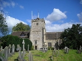
, born two miles (3 km) from Warnham at Field Place, a broad-fronted country house set on an estate/working farm, was baptised there in 1792 and later rode every day for lessons with Reverend Edwards, the church vicar. In addition it houses monuments belonging to a number of influential Sussex families, among them the Carylls, the Lucases and the Shelleys.
Warnham has a number of shops, including a village store and butcher, two pubs The Sussex Oak and The Greets Inn, and Warnham railway station
lies nearly a mile away from the village, on the Sutton & Mole Valley Lines. The station was built primarily for the brick works, which had some sidings until recently. It only offers a passenger service during peak times. The level crossing is now permanently closed.
Village
A village is a clustered human settlement or community, larger than a hamlet with the population ranging from a few hundred to a few thousand , Though often located in rural areas, the term urban village is also applied to certain urban neighbourhoods, such as the West Village in Manhattan, New...
and civil parish
Civil parish
In England, a civil parish is a territorial designation and, where they are found, the lowest tier of local government below districts and counties...
in the Horsham
Horsham (district)
Horsham is a local government district in West Sussex, England. Its council is based in Horsham. The district borders those of Crawley, Mid Sussex, Mole Valley, Chichester, Arun and Adur....
district of West Sussex
West Sussex
West Sussex is a county in the south of England, bordering onto East Sussex , Hampshire and Surrey. The county of Sussex has been divided into East and West since the 12th century, and obtained separate county councils in 1888, but it remained a single ceremonial county until 1974 and the coming...
, England
England
England is a country that is part of the United Kingdom. It shares land borders with Scotland to the north and Wales to the west; the Irish Sea is to the north west, the Celtic Sea to the south west, with the North Sea to the east and the English Channel to the south separating it from continental...
. The village is some three kilometres (2 miles) north west of central Horsham
Horsham
Horsham is a market town with a population of 55,657 on the upper reaches of the River Arun in the centre of the Weald, West Sussex, in the historic County of Sussex, England. The town is south south-west of London, north-west of Brighton and north-east of the county town of Chichester...
to the west of the A24
A24 road (Great Britain)
The A24 is a major road in England. It runs south from Clapham in southwest London through Morden before entering Surrey and heading through Ewell, Epsom, Ashtead, Leatherhead and Dorking...
road. Other named settlements within the parish include the hamlets of Goose Green, Kingsfold and Winterfold as well as parts of Strood Green and Rowhook.
The parish has a land area of 1980 hectares (4892 acres). In the 2001 census 1958 people lived in 784 households, of whom 935 were economically active.
The Anglican
Anglicanism
Anglicanism is a tradition within Christianity comprising churches with historical connections to the Church of England or similar beliefs, worship and church structures. The word Anglican originates in ecclesia anglicana, a medieval Latin phrase dating to at least 1246 that means the English...
Parish Church, dedicated to St. Margaret was built in the 14th Century, but contains substantial later additions. The poet Percy Bysshe Shelley
Percy Bysshe Shelley
Percy Bysshe Shelley was one of the major English Romantic poets and is critically regarded as among the finest lyric poets in the English language. Shelley was famous for his association with John Keats and Lord Byron...
, born two miles (3 km) from Warnham at Field Place, a broad-fronted country house set on an estate/working farm, was baptised there in 1792 and later rode every day for lessons with Reverend Edwards, the church vicar. In addition it houses monuments belonging to a number of influential Sussex families, among them the Carylls, the Lucases and the Shelleys.
Warnham has a number of shops, including a village store and butcher, two pubs The Sussex Oak and The Greets Inn, and Warnham railway station
Warnham railway station
Warnham railway station serves the village of Warnham in West Sussex, England. The station is 60 km south of London Victoria. Warnham is managed by Southern who also provide all rail services.- Services :...
lies nearly a mile away from the village, on the Sutton & Mole Valley Lines. The station was built primarily for the brick works, which had some sidings until recently. It only offers a passenger service during peak times. The level crossing is now permanently closed.