
Wahluke Slope AVA
Encyclopedia
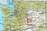
The Wahluke Slope AVA is an American Viticultural Area
located within Grant County, Washington
. It is part of the larger Columbia Valley AVA
. The area is primarily known for Merlot
and Cabernet Sauvignon
.
 The Wahluke Slope AVA is located in Grant County, Washington. It extends from the Columbia River
in the west, the Hanford Site
boundary in the southwest, the north bank of the Columbia River
on the south up to the Wahluke Slope Wildlife Refuge in the east, and along the 1480 feet (451.1 m) elevation of the Saddle Mountains
on the north. The area has the warmest climates for grape growing in the state.
American Viticultural Area
An American Viticultural Area is a designated wine grape-growing region in the United States distinguishable by geographic features, with boundaries defined by the Alcohol and Tobacco Tax and Trade Bureau , United States Department of the Treasury....
located within Grant County, Washington
Washington State
Washington State may refer to:* Washington , often referred to as "Washington state" to differentiate it from Washington, D.C., the capital of the United States* Washington State University, a land-grant college in that state- See also :...
. It is part of the larger Columbia Valley AVA
Columbia Valley AVA
The Columbia Valley AVA is an American Viticultural Area which lies in the Columbia River Plateau, through much of central and southern Washington state, with a small section crossing into the neighboring state of Oregon. The AVA includes the drainage basin of the Columbia River and its tributaries...
. The area is primarily known for Merlot
Merlot
Merlot is a darkly blue-coloured wine grape, that is used as both a blending grape and for varietal wines. The name Merlot is thought to derive from the Old French word for young blackbird, merlot, a diminutive of merle, the blackbird , probably from the color of the grape. Merlot-based wines...
and Cabernet Sauvignon
Cabernet Sauvignon
Cabernet Sauvignon is one of the world's most widely recognized red wine grape varieties. It is grown in nearly every major wine producing country among a diverse spectrum of climates from Canada's Okanagan Valley to Lebanon's Beqaa Valley...
.
Geography and climate
Columbia River
The Columbia River is the largest river in the Pacific Northwest region of North America. The river rises in the Rocky Mountains of British Columbia, Canada, flows northwest and then south into the U.S. state of Washington, then turns west to form most of the border between Washington and the state...
in the west, the Hanford Site
Hanford Site
The Hanford Site is a mostly decommissioned nuclear production complex on the Columbia River in the U.S. state of Washington, operated by the United States federal government. The site has been known by many names, including Hanford Works, Hanford Engineer Works or HEW, Hanford Nuclear Reservation...
boundary in the southwest, the north bank of the Columbia River
Columbia River
The Columbia River is the largest river in the Pacific Northwest region of North America. The river rises in the Rocky Mountains of British Columbia, Canada, flows northwest and then south into the U.S. state of Washington, then turns west to form most of the border between Washington and the state...
on the south up to the Wahluke Slope Wildlife Refuge in the east, and along the 1480 feet (451.1 m) elevation of the Saddle Mountains
Saddle Mountains
The Saddle Mountains consists of an upfolded anticline ridge of basalt in Grant County of central Washington state. The ridge, reaching to 2,700 feet, terminates in the east south of Othello, Washington near the foot of the Drumheller Channels...
on the north. The area has the warmest climates for grape growing in the state.