
Vuoksi River
Encyclopedia
The Vuoksi River runs in the northernmost part of the Karelian Isthmus
from Lake Saimaa in southeastern Finland
to Lake Ladoga
in northwestern Russia
. The river enters Lake Ladoga in three branches, an older main northern branch at Priozersk
(Käkisalmi), a smaller branch few km. to the north of it and since 1857 a new southern branch entering fifty kilometers further southeast as Burnaya River
(Finnish: Taipaleenjoki), which has become the main stream in terms of water discharge. The old northern distributaries drain only the lower reaches of the Vuoksi basin after 1857 and are not fed by waters of the Lake Saimaa. Northern and southern branches actually belong to two separate river systems, which at times get isolated from each other in dry seasons.
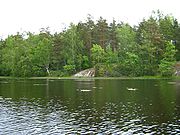
The descent between Lake Saimaa and Lake Ladoga is 69 meters. The entire run of the river is 162 kilometers via the Priozersk branch or 150 kilometers via the Taipale branch. For most of its length, the river broadens out to a series of lakes bound together by shorter riverlike connections. One of these lakes, Uusijärvi close to Priozersk, was renamed by the Soviets to Ozero Vuoksa ("Lake Vuoksa").
 The Vuoksi connects Lake Ladoga with central Finland, and was once an important route for trade and communication. A western branch, which disappeared due to ongoing land uplift, was an alternative route for the Karelians
to reach the Gulf of Finland
when the River Neva was blocked by enemies. Now the Saimaa Canal
bypasses the Vuoksi and enters the Gulf of Finland in the Bay of Vyborg near the medieval city of Vyborg
.
During both the Winter
and Continuation War
s the river Vuoksi was a major Finnish defensive line
against the Soviet advance. The Mannerheim Line
and VKT-line
were situated along the northern shore of its southern armlet.
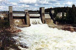
At the Industrial Revolution
, power generated from Vuoksi's rapids made the Vuoksi region Finland's industrial center in the late 19th century. Since the Winter War (1940), the Karelian Isthmus belongs to Russia and only 13 kilometers of the river's length remains in Finland.
The major power station
s at Tainionkoski and Imatra are on the Finnish side in the center of the city of Imatra
.
The river's surroundings, including the Korela Fortress
(formerly: Käkisalmi), is a popular resort for Saint Petersburg
's residents.
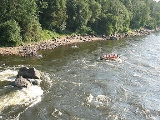
The river is famous for the great rapid
s, for instance at Imatra
and the village of Losevo
(Kiviniemi). The rapid junction of the Vuoksi and Suvanto/Lake Sukhodolskoye
at Losevo is a popular place of kayak
, canoe
and catamaran
competitions.
A project is currently being discussed in Russia to destroy the rapids at Losevo and turn the River Burnaya, Lake Sukhodolskoye and lower portions of Vuoksi into a navigable canal, which would connect Lake Ladoga
to the Gulf of Finland
and allow oil tankers to bypass River Neva and the city of Saint Petersburg
. http://www.ecominfo.spb.ru/news/index.php?id=1019
 Around 5,000 BP the waters of the Saimaa Lake penetrated Salpausselkä
and formed the river emptying into Lake Ladoga
in its northwestern corner and raising the level of the latter by 1–2 m. Lake Ladoga transgressed
, flooding lowland lakes and Vuoksi, and connected with the Baltic Sea
at Heinjoki, to the east of present-day Vyborg
. Ladoga level gradually sank as the River Neva had originated around 3100–2400 BP, draining its waters into the gulf of Finland
, but Vuoksi still had a significant direct outflow connection to the Bay of Vyborg, possibly as late as in the 16th or 17th century AD. The connection disappeared due to ongoing land uplift.
In 1818 a canal, which was dug to drain spring flood waters from Lake Suvanto (now Lake Sukhodolskoye, a 40-km long narrow lake in the eastern part of the Karelian Isthmus
) into Lake Ladoga
, unexpectedly eroded and turned into Taipaleenjoki (now Burnaya River). Taipaleenjoki started draining Suvanto and decreased its level by 7 m. Originally waters of Lake Suvanto flowed into Vuoksi River through a waterway at Kiviniemi
(now Losevo), but as a result of the change, the waterway dried out. In 1857 the channel was dug there, but the stream reversed direction, revealed rapids and rendered navigation at Kiviniemi impossible. Since 1857 Suvanto and Taipaleenjoki have constituted the southern armlet of Vuoksi River, which has decreased the level of the original northern armlet emptying into Ladoga near Kexholm (now Priozersk) by 4 m and become the main stream.
Karelian Isthmus
The Karelian Isthmus is the approximately 45–110 km wide stretch of land, situated between the Gulf of Finland and Lake Ladoga in northwestern Russia, to the north of the River Neva . Its northwestern boundary is the relatively narrow area between the Bay of Vyborg and Lake Ladoga...
from Lake Saimaa in southeastern Finland
Finland
Finland , officially the Republic of Finland, is a Nordic country situated in the Fennoscandian region of Northern Europe. It is bordered by Sweden in the west, Norway in the north and Russia in the east, while Estonia lies to its south across the Gulf of Finland.Around 5.4 million people reside...
to Lake Ladoga
Lake Ladoga
Lake Ladoga is a freshwater lake located in the Republic of Karelia and Leningrad Oblast in northwestern Russia, not far from Saint Petersburg. It is the largest lake in Europe, and the 14th largest lake by area in the world.-Geography:...
in northwestern Russia
Russia
Russia or , officially known as both Russia and the Russian Federation , is a country in northern Eurasia. It is a federal semi-presidential republic, comprising 83 federal subjects...
. The river enters Lake Ladoga in three branches, an older main northern branch at Priozersk
Priozersk
Priozersk is a town in Leningrad Oblast, Russia, centered on an island at the southwestern shore of Lake Ladoga, at the estuary of the northern armlet of River Vuoksi on the Karelian Isthmus. It is served by a station of the Saint Petersburg-Kuznechnoye railroad with the same name...
(Käkisalmi), a smaller branch few km. to the north of it and since 1857 a new southern branch entering fifty kilometers further southeast as Burnaya River
Burnaya River
The Burnaya is a young rapid river in Priozersk District of Leningrad Oblast, Russia, on the Karelian Isthmus, which emerged in 1818. It flows from Lake Sukhodolskoye to Lake Ladoga and is a part of Vuoksi River drainage basin...
(Finnish: Taipaleenjoki), which has become the main stream in terms of water discharge. The old northern distributaries drain only the lower reaches of the Vuoksi basin after 1857 and are not fed by waters of the Lake Saimaa. Northern and southern branches actually belong to two separate river systems, which at times get isolated from each other in dry seasons.
The descent between Lake Saimaa and Lake Ladoga is 69 meters. The entire run of the river is 162 kilometers via the Priozersk branch or 150 kilometers via the Taipale branch. For most of its length, the river broadens out to a series of lakes bound together by shorter riverlike connections. One of these lakes, Uusijärvi close to Priozersk, was renamed by the Soviets to Ozero Vuoksa ("Lake Vuoksa").
Karelians
The Karelians are a Baltic-Finnic ethnic group living mostly in the Republic of Karelia and in other north-western parts of the Russian Federation. The historic homeland of Karelians includes also parts of present-day Eastern Finland and the formerly Finnish territory of Ladoga Karelia...
to reach the Gulf of Finland
Gulf of Finland
The Gulf of Finland is the easternmost arm of the Baltic Sea. It extends between Finland and Estonia all the way to Saint Petersburg in Russia, where the river Neva drains into it. Other major cities around the gulf include Helsinki and Tallinn...
when the River Neva was blocked by enemies. Now the Saimaa Canal
Saimaa Canal
The Saimaa Canal is a transportation canal that connects lake Saimaa with the Gulf of Finland near Vyborg, Russia. The canal was built from 1845 to 1856 and opened on 7 September 1856 .It was overhauled and widened in 1963–1968....
bypasses the Vuoksi and enters the Gulf of Finland in the Bay of Vyborg near the medieval city of Vyborg
Vyborg
Vyborg is a town in Leningrad Oblast, Russia, situated on the Karelian Isthmus near the head of the Bay of Vyborg, to the northwest of St. Petersburg and south from Russia's border with Finland, where the Saimaa Canal enters the Gulf of Finland...
.
During both the Winter
Winter War
The Winter War was a military conflict between the Soviet Union and Finland. It began with a Soviet offensive on 30 November 1939 – three months after the start of World War II and the Soviet invasion of Poland – and ended on 13 March 1940 with the Moscow Peace Treaty...
and Continuation War
Continuation War
The Continuation War was the second of two wars fought between Finland and the Soviet Union during World War II.At the time of the war, the Finnish side used the name to make clear its perceived relationship to the preceding Winter War...
s the river Vuoksi was a major Finnish defensive line
Mannerheim Line
The Mannerheim Line was a defensive fortification line on the Karelian Isthmus built by Finland against the Soviet Union. During the Winter War it became known as the Mannerheim Line, after Field Marshal Baron Carl Gustaf Emil Mannerheim. The line was constructed in two phases: 1920–1924 and...
against the Soviet advance. The Mannerheim Line
Mannerheim Line
The Mannerheim Line was a defensive fortification line on the Karelian Isthmus built by Finland against the Soviet Union. During the Winter War it became known as the Mannerheim Line, after Field Marshal Baron Carl Gustaf Emil Mannerheim. The line was constructed in two phases: 1920–1924 and...
and VKT-line
VKT-line
The VKT-line or Viipuri–Kuparsaari–Taipale line was a Finnish defensive line on Karelian Isthmus during the Continuation War, spanning from Viipuri through Tali and Kuparsaari along the northern shore of Vuoksi River, Suvanto and Taipaleenjoki to Taipale on the western shore of Lake Ladoga, using...
were situated along the northern shore of its southern armlet.
At the Industrial Revolution
Industrial Revolution
The Industrial Revolution was a period from the 18th to the 19th century where major changes in agriculture, manufacturing, mining, transportation, and technology had a profound effect on the social, economic and cultural conditions of the times...
, power generated from Vuoksi's rapids made the Vuoksi region Finland's industrial center in the late 19th century. Since the Winter War (1940), the Karelian Isthmus belongs to Russia and only 13 kilometers of the river's length remains in Finland.
The major power station
Hydroelectricity
Hydroelectricity is the term referring to electricity generated by hydropower; the production of electrical power through the use of the gravitational force of falling or flowing water. It is the most widely used form of renewable energy...
s at Tainionkoski and Imatra are on the Finnish side in the center of the city of Imatra
Imatra
Imatra is a town and municipality in eastern Finland, founded in 1948 around three industrial settlements near the Finnish–Russian border. In the course of the last 50 years, this amorphous group of settlements has grown into a modern industrial town dominated by Lake Saimaa, the Vuoksi River and...
.
The river's surroundings, including the Korela Fortress
Korela Fortress
Korela Fortress , at the town of Priozersk, was founded by the Karelians who named the place Käkisalmi.- Origin :...
(formerly: Käkisalmi), is a popular resort for Saint Petersburg
Saint Petersburg
Saint Petersburg is a city and a federal subject of Russia located on the Neva River at the head of the Gulf of Finland on the Baltic Sea...
's residents.
The river is famous for the great rapid
Rapid
A rapid is a section of a river where the river bed has a relatively steep gradient causing an increase in water velocity and turbulence. A rapid is a hydrological feature between a run and a cascade. A rapid is characterised by the river becoming shallower and having some rocks exposed above the...
s, for instance at Imatra
Imatra
Imatra is a town and municipality in eastern Finland, founded in 1948 around three industrial settlements near the Finnish–Russian border. In the course of the last 50 years, this amorphous group of settlements has grown into a modern industrial town dominated by Lake Saimaa, the Vuoksi River and...
and the village of Losevo
Losevo, Leningrad Oblast
Losevo is a station settlement in Priozersky District, Leningrad Oblast, located at the junction of Vuoksi River and Lake Sukhodolskoye on Karelian Isthmus. It is a railway station of the Saint Petersburg–Khiytola railroad...
(Kiviniemi). The rapid junction of the Vuoksi and Suvanto/Lake Sukhodolskoye
Lake Sukhodolskoye
Lake Sukhodolskoye is a narrow 40 km long lake on the Karelian Isthmus located in Priozersk District of Leningrad Oblast, Russia. It is a part of the Vuoksi River basin, constituting its southern armlet, and drained by Burnaya River....
at Losevo is a popular place of kayak
Kayak
A kayak is a small, relatively narrow, human-powered boat primarily designed to be manually propelled by means of a double blade paddle.The traditional kayak has a covered deck and one or more cockpits, each seating one paddler...
, canoe
Canoe
A canoe or Canadian canoe is a small narrow boat, typically human-powered, though it may also be powered by sails or small electric or gas motors. Canoes are usually pointed at both bow and stern and are normally open on top, but can be decked over A canoe (North American English) or Canadian...
and catamaran
Catamaran
A catamaran is a type of multihulled boat or ship consisting of two hulls, or vakas, joined by some structure, the most basic being a frame, formed of akas...
competitions.
A project is currently being discussed in Russia to destroy the rapids at Losevo and turn the River Burnaya, Lake Sukhodolskoye and lower portions of Vuoksi into a navigable canal, which would connect Lake Ladoga
Lake Ladoga
Lake Ladoga is a freshwater lake located in the Republic of Karelia and Leningrad Oblast in northwestern Russia, not far from Saint Petersburg. It is the largest lake in Europe, and the 14th largest lake by area in the world.-Geography:...
to the Gulf of Finland
Gulf of Finland
The Gulf of Finland is the easternmost arm of the Baltic Sea. It extends between Finland and Estonia all the way to Saint Petersburg in Russia, where the river Neva drains into it. Other major cities around the gulf include Helsinki and Tallinn...
and allow oil tankers to bypass River Neva and the city of Saint Petersburg
Saint Petersburg
Saint Petersburg is a city and a federal subject of Russia located on the Neva River at the head of the Gulf of Finland on the Baltic Sea...
. http://www.ecominfo.spb.ru/news/index.php?id=1019
Geological history
Salpausselkä
Salpausselkä is an extensive ridge system left by the ice age in Southern Finland. It is a large terminal moraine formation that formed in front of the Baltic ice lake during the Younger Dryas period about 12.250 - 10.400 years ago....
and formed the river emptying into Lake Ladoga
Lake Ladoga
Lake Ladoga is a freshwater lake located in the Republic of Karelia and Leningrad Oblast in northwestern Russia, not far from Saint Petersburg. It is the largest lake in Europe, and the 14th largest lake by area in the world.-Geography:...
in its northwestern corner and raising the level of the latter by 1–2 m. Lake Ladoga transgressed
Transgression (geology)
A marine transgression is a geologic event during which sea level rises relative to the land and the shoreline moves toward higher ground, resulting in flooding. Transgressions can be caused either by the land sinking or the ocean basins filling with water...
, flooding lowland lakes and Vuoksi, and connected with the Baltic Sea
Baltic Sea
The Baltic Sea is a brackish mediterranean sea located in Northern Europe, from 53°N to 66°N latitude and from 20°E to 26°E longitude. It is bounded by the Scandinavian Peninsula, the mainland of Europe, and the Danish islands. It drains into the Kattegat by way of the Øresund, the Great Belt and...
at Heinjoki, to the east of present-day Vyborg
Vyborg
Vyborg is a town in Leningrad Oblast, Russia, situated on the Karelian Isthmus near the head of the Bay of Vyborg, to the northwest of St. Petersburg and south from Russia's border with Finland, where the Saimaa Canal enters the Gulf of Finland...
. Ladoga level gradually sank as the River Neva had originated around 3100–2400 BP, draining its waters into the gulf of Finland
Gulf of Finland
The Gulf of Finland is the easternmost arm of the Baltic Sea. It extends between Finland and Estonia all the way to Saint Petersburg in Russia, where the river Neva drains into it. Other major cities around the gulf include Helsinki and Tallinn...
, but Vuoksi still had a significant direct outflow connection to the Bay of Vyborg, possibly as late as in the 16th or 17th century AD. The connection disappeared due to ongoing land uplift.
In 1818 a canal, which was dug to drain spring flood waters from Lake Suvanto (now Lake Sukhodolskoye, a 40-km long narrow lake in the eastern part of the Karelian Isthmus
Karelian Isthmus
The Karelian Isthmus is the approximately 45–110 km wide stretch of land, situated between the Gulf of Finland and Lake Ladoga in northwestern Russia, to the north of the River Neva . Its northwestern boundary is the relatively narrow area between the Bay of Vyborg and Lake Ladoga...
) into Lake Ladoga
Lake Ladoga
Lake Ladoga is a freshwater lake located in the Republic of Karelia and Leningrad Oblast in northwestern Russia, not far from Saint Petersburg. It is the largest lake in Europe, and the 14th largest lake by area in the world.-Geography:...
, unexpectedly eroded and turned into Taipaleenjoki (now Burnaya River). Taipaleenjoki started draining Suvanto and decreased its level by 7 m. Originally waters of Lake Suvanto flowed into Vuoksi River through a waterway at Kiviniemi
Kiviniemi
Kiviniemi may refer to*Mari Kiviniemi, Finnish politician*Kalevi Kiviniemi, Finnish concert organist*Losevo, Leningrad Oblast...
(now Losevo), but as a result of the change, the waterway dried out. In 1857 the channel was dug there, but the stream reversed direction, revealed rapids and rendered navigation at Kiviniemi impossible. Since 1857 Suvanto and Taipaleenjoki have constituted the southern armlet of Vuoksi River, which has decreased the level of the original northern armlet emptying into Ladoga near Kexholm (now Priozersk) by 4 m and become the main stream.