

Volcanic passive margin
Encyclopedia
Volcanic passive margins (VPM) and non-volcanic passive margins
are the two forms of transitional crust
that lie beneath passive continental margins
that occur on Earth as the result of the formation of ocean basins via continental rifting. Initiation of igneous processes associated with volcanic passive margins occurs before and/or during the rifting process depending on the cause of rifting. There are two accepted models for VPM formation: hotspot
s/mantle plume
s and slab pull. Both result in large, quick lava
flows over a relatively short period of geologic time
(i.e. a couple of million years). VPM’s progress further as cooling and subsidence
begins as the margins give way to formation of normal oceanic crust
from the widening rifts.
related upwelling form reservoirs of magma
from which dike swarm
s and sill
s eventually radiate to the surface, creating the characteristic seaward dipping lava flows. This model is controversial.
s. Rhyolite
and other felsic rocks can also be found in these zones.
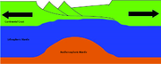
Continued extension with volcanic activity forms transitional crust, welding ruptured continent to nascent ocean floor. Volcanic beds cover the transition from thinned continental crust to oceanic crust. Also occurring during this phase is the formation of high velocity seismic zones under the thinned continental crust and the transition crust. These zones are identified by typical seismic velocities between 7.2-7.7 km/s and are usually interpreted as layers of mafic to ultramafic rocks that have underplated the transitional crust.
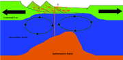
Asthenspheric upwelling leads to the formation of a mid-ocean ridge and new oceanic crust progressively separates the once-conjoined rift halves. Continued volcanic eruptions spread lava flows across transitional crust and onto oceanic crust. Due to the high rate of magmatic activity the new oceanic crust forms much thicker than typical oceanic crust. An example of this is Iceland where oceanic crust has been identified as being up to 40 km thick. Some have theorized that the copious amounts of volcanic material also lead to the formation of oceanic plateaus at this time.
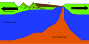
The final and longest phase is the continued thermal subsidence
of the transitional crust and the accumulation of sediments. Continued seafloor spreading leads to the formation of oceanic crust of normal thickness. Over time this production of normal oceanic crust and sea floor spreading leads to the formation of an ocean. This phase is of the most interest to the oil industry and sedimentary geologists.
Volcanic passive margins:
The central eastern North American continental shelf
is one of the world’s largest volcanic passive margins. It extends from the Carolina Trough to the Scotia Basin. It has a typical history of tectonic events that are representative of volcanic passive margins such as rifting, breakup and seafloor spreading. Rifting and passive margin formation occurred 225-165 million years ago. It includes characteristic seaward-dipping reflectors, flood basalts, dikes, and sills.
Like other volcanic passive margins, it developed in two stages. First came rifting, initiated during the Middle to Late Triassic
and continued into Jurassic
time.
The second stage involved seafloor spreading, which began in Jurassic time and continues today. This is when North America separated from Africa to form the Atlantic Ocean
.
Non-Volcanic Passive Margins
Non-volcanic passive margins constitute one end member of the transitional crustal types that lie beneath passive continental margins; the other end member being volcanic passive margins . Transitional crust welds continental crust to oceanic crust along the lines of continental break-up...
are the two forms of transitional crust
Crust (geology)
In geology, the crust is the outermost solid shell of a rocky planet or natural satellite, which is chemically distinct from the underlying mantle...
that lie beneath passive continental margins
Passive margin
A passive margin is the transition between oceanic and continental crust which is not an active plate margin. It is constructed by sedimentation above an ancient rift, now marked by transitional crust. Continental rifting creates new ocean basins. Eventually the continental rift forms a mid-oceanic...
that occur on Earth as the result of the formation of ocean basins via continental rifting. Initiation of igneous processes associated with volcanic passive margins occurs before and/or during the rifting process depending on the cause of rifting. There are two accepted models for VPM formation: hotspot
Hotspot (geology)
The places known as hotspots or hot spots in geology are volcanic regions thought to be fed by underlying mantle that is anomalously hot compared with the mantle elsewhere. They may be on, near to, or far from tectonic plate boundaries. There are two hypotheses to explain them...
s/mantle plume
Mantle plume
A mantle plume is a hypothetical thermal diapir of abnormally hot rock that nucleates at the core-mantle boundary and rises through the Earth's mantle. Such plumes were invoked in 1971 to explain volcanic regions that were not thought to be explicable by the then-new theory of plate tectonics. Some...
s and slab pull. Both result in large, quick lava
Lava
Lava refers both to molten rock expelled by a volcano during an eruption and the resulting rock after solidification and cooling. This molten rock is formed in the interior of some planets, including Earth, and some of their satellites. When first erupted from a volcanic vent, lava is a liquid at...
flows over a relatively short period of geologic time
Geologic time scale
The geologic time scale provides a system of chronologic measurement relating stratigraphy to time that is used by geologists, paleontologists and other earth scientists to describe the timing and relationships between events that have occurred during the history of the Earth...
(i.e. a couple of million years). VPM’s progress further as cooling and subsidence
Subsidence
Subsidence is the motion of a surface as it shifts downward relative to a datum such as sea-level. The opposite of subsidence is uplift, which results in an increase in elevation...
begins as the margins give way to formation of normal oceanic crust
Oceanic crust
Oceanic crust is the part of Earth's lithosphere that surfaces in the ocean basins. Oceanic crust is primarily composed of mafic rocks, or sima, which is rich in iron and magnesium...
from the widening rifts.
Characteristics
Despite the differences in origin and formation, most VPMs share the same characteristics:- 4 to 7 km thick basaltic and (frequently) silicicSilicicSilicic is a term used to describe magma or igneous rock rich in silica. The amount of silica that constitutes a silicic rock is usually put at at least 65 percent. Granite and rhyolite are typical silicic rocks....
subaerialSubaerialThe term subaerial is mainly used in geology to describe events or structures that are located at the Earth's surface...
flows; dike swarms and sills running parallel to continent-facing normal faults.
- 10 to 15 km thick bodies in the lower crust (HVLC) show high seismic P-WaveP-waveP-waves are a type of elastic wave, also called seismic waves, that can travel through gases , solids and liquids, including the Earth. P-waves are produced by earthquakes and recorded by seismographs...
velocities, between 7.1 and 7.8 km/s which lie under the transitional crustContinent-ocean boundaryThe Continent-ocean boundary or continent-ocean transition is the boundary between continental crust and oceanic crust on a passive margin. The identification of continent-ocean boundaries is important in the definition of plate boundaries at the time of break-up when trying to reconstruct the...
(crust between continental crustContinental crustThe continental crust is the layer of igneous, sedimentary, and metamorphic rocks which form the continents and the areas of shallow seabed close to their shores, known as continental shelves. This layer is sometimes called sial due to more felsic, or granitic, bulk composition, which lies in...
and oceanic crustOceanic crustOceanic crust is the part of Earth's lithosphere that surfaces in the ocean basins. Oceanic crust is primarily composed of mafic rocks, or sima, which is rich in iron and magnesium...
).
- Seaward Dipping Reflector (SDR) series: Inner SDR’s overlay transitional continental crust. They are composed of varying mixtures of subaerial volcanic flows, volcaniclastic and non-volcanic sediments which range from 50–150 km wide and are 5–10 km thick. Outer SDR’s overlay transitional oceanic crust are composed of submarine basaltic flows which range from 3 to 9 km thick.
Development
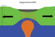
Active rifting
The active rift model sees rupture driven by hotspot or mantle plume activity. Upwellings of hot mantle, known as mantle plumes, originate deep in Earth and rise to heat and thin the lithosphere. Heated lithosphere thins, weakens, rises, and finally rifts, Enhanced melting following continental breakup is very important in VPMs, creating thicker than normal oceanic crust of 20 to 40 km thick. Other melts caused by convectionConvection
Convection is the movement of molecules within fluids and rheids. It cannot take place in solids, since neither bulk current flows nor significant diffusion can take place in solids....
related upwelling form reservoirs of magma
Magma
Magma is a mixture of molten rock, volatiles and solids that is found beneath the surface of the Earth, and is expected to exist on other terrestrial planets. Besides molten rock, magma may also contain suspended crystals and dissolved gas and sometimes also gas bubbles. Magma often collects in...
from which dike swarm
Dike swarm
A dike swarm or dyke swarm is a large geological structure consisting of a major group of parallel, linear, or radially oriented dikes intruded within continental crust. They consist of several to hundreds of dikes emplaced more or less contemporaneously during a single intrusive event and are...
s and sill
Sill (geology)
In geology, a sill is a tabular sheet intrusion that has intruded between older layers of sedimentary rock, beds of volcanic lava or tuff, or even along the direction of foliation in metamorphic rock. The term sill is synonymous with concordant intrusive sheet...
s eventually radiate to the surface, creating the characteristic seaward dipping lava flows. This model is controversial.
Passive rifting
The passive rift model infers that slab pull stretches the lithosphere and thins it. To compensate for lithospheric thinning, asthenosphere upwells, meltsdue to adiabatic decompression, and derivative melts rise to the surface to erupt. Melts push up through faults towards the surface, forming dikes and sills.Development of transitional crust
Continued extension leads to accelerated igneous activity, including repeated eruptions. Repeated eruptions form a thick sequence of lava beds that can reach a combined thickness of up to 20 km. These beds are identified on seismic refraction sections as seaward dipping reflectors. It is important to note that the early phase of volcanic activity is not limited to the production of basaltBasalt
Basalt is a common extrusive volcanic rock. It is usually grey to black and fine-grained due to rapid cooling of lava at the surface of a planet. It may be porphyritic containing larger crystals in a fine matrix, or vesicular, or frothy scoria. Unweathered basalt is black or grey...
s. Rhyolite
Rhyolite
This page is about a volcanic rock. For the ghost town see Rhyolite, Nevada, and for the satellite system, see Rhyolite/Aquacade.Rhyolite is an igneous, volcanic rock, of felsic composition . It may have any texture from glassy to aphanitic to porphyritic...
and other felsic rocks can also be found in these zones.
Continued extension with volcanic activity forms transitional crust, welding ruptured continent to nascent ocean floor. Volcanic beds cover the transition from thinned continental crust to oceanic crust. Also occurring during this phase is the formation of high velocity seismic zones under the thinned continental crust and the transition crust. These zones are identified by typical seismic velocities between 7.2-7.7 km/s and are usually interpreted as layers of mafic to ultramafic rocks that have underplated the transitional crust.
Asthenspheric upwelling leads to the formation of a mid-ocean ridge and new oceanic crust progressively separates the once-conjoined rift halves. Continued volcanic eruptions spread lava flows across transitional crust and onto oceanic crust. Due to the high rate of magmatic activity the new oceanic crust forms much thicker than typical oceanic crust. An example of this is Iceland where oceanic crust has been identified as being up to 40 km thick. Some have theorized that the copious amounts of volcanic material also lead to the formation of oceanic plateaus at this time.
Post-rift
The final and longest phase is the continued thermal subsidence
Thermal subsidence
In geology and geophysics, thermal subsidence is a mechanism of subsidence in which conductive cooling of the mantle thickens the lithosphere and causes it to decrease in elevation. This is because of thermal contraction: as mantle material cools and becomes part of the mechanically-rigid...
of the transitional crust and the accumulation of sediments. Continued seafloor spreading leads to the formation of oceanic crust of normal thickness. Over time this production of normal oceanic crust and sea floor spreading leads to the formation of an ocean. This phase is of the most interest to the oil industry and sedimentary geologists.
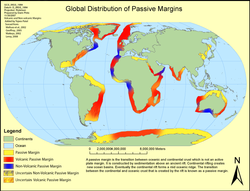
Distribution and examples
The distribution of known volcanic margins is shown on the graphic to the right. Many of the margins have not been thoroughly investigated and more passive margins are identified as volcanic from time to time.Volcanic passive margins:
- South Atlantic
- Western Australia
- Southwest India
- Southern Greenland
- South of Arabia
- Norwegian
Example of volcanic passive margin
The US Atlantic passive margin extends from Florida to southern Nova Scotia. It is the result of the breakup of the supercontinent, Pangea, when North America separated from northwestern Africa and Iberia to form the Atlantic Ocean.The central eastern North American continental shelf
Continental shelf
The continental shelf is the extended perimeter of each continent and associated coastal plain. Much of the shelf was exposed during glacial periods, but is now submerged under relatively shallow seas and gulfs, and was similarly submerged during other interglacial periods. The continental margin,...
is one of the world’s largest volcanic passive margins. It extends from the Carolina Trough to the Scotia Basin. It has a typical history of tectonic events that are representative of volcanic passive margins such as rifting, breakup and seafloor spreading. Rifting and passive margin formation occurred 225-165 million years ago. It includes characteristic seaward-dipping reflectors, flood basalts, dikes, and sills.
Like other volcanic passive margins, it developed in two stages. First came rifting, initiated during the Middle to Late Triassic
Triassic
The Triassic is a geologic period and system that extends from about 250 to 200 Mya . As the first period of the Mesozoic Era, the Triassic follows the Permian and is followed by the Jurassic. Both the start and end of the Triassic are marked by major extinction events...
and continued into Jurassic
Jurassic
The Jurassic is a geologic period and system that extends from about Mya to Mya, that is, from the end of the Triassic to the beginning of the Cretaceous. The Jurassic constitutes the middle period of the Mesozoic era, also known as the age of reptiles. The start of the period is marked by...
time.
The second stage involved seafloor spreading, which began in Jurassic time and continues today. This is when North America separated from Africa to form the Atlantic Ocean
Atlantic Ocean
The Atlantic Ocean is the second-largest of the world's oceanic divisions. With a total area of about , it covers approximately 20% of the Earth's surface and about 26% of its water surface area...
.