

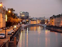
Vodootvodny Canal
Encyclopedia
Moscow
Moscow is the capital, the most populous city, and the most populous federal subject of Russia. The city is a major political, economic, cultural, scientific, religious, financial, educational, and transportation centre of Russia and the continent...
, Russia
Russia
Russia or , officially known as both Russia and the Russian Federation , is a country in northern Eurasia. It is a federal semi-presidential republic, comprising 83 federal subjects...
. It was built in 1780s on the old riverbed
Riverbed
Riverbed may refer to:*Stream bed, the channel bottom of a stream or river or creek*Wadi, a dry riverbed that contains water only during times of heavy rain*Riverbed Technology, an American technology company...
of Moskva River
Moskva River
The Moskva River is a river that flows through the Moscow and Smolensk Oblasts in Russia, and is a tributary of the Oka River.-Etymology:...
to control flood
Flood
A flood is an overflow of an expanse of water that submerges land. The EU Floods directive defines a flood as a temporary covering by water of land not normally covered by water...
s and support shipping. Canal construction created an island
Balchug
Balchug , also known as Bolotny Ostrov , is an island in the very centre of Moscow, Russia, squeezed between the Moskva River and its old river-bed which was turned into the Vodootvodny Canal in 1786...
between Moskva river and the canal. The island acquired its present shape in 1938, with the completion of Moscow Canal
Moscow Canal
The Moscow Canal , named the Moscow-Volga Canal until the year 1947, is a canal that connects the Moskva River with the main transportation artery of European Russia, the Volga River. It is located in Moscow itself and in the Moscow Oblast...
megaproject
Megaproject
A megaproject is an extremely large-scale investment project. Megaprojects are typically defined as costing more than US$1 billion and attracting a lot of public attention because of substantial impacts on communities, environment, and budgets. Megaprojects can also be defined as "initiatives that...
. Canal is spanned by ten bridges, the eleventh is now under construction.
Moscow floods
Zamoskvorechye
Zamoskvorechye District is a district of Central Administrative Okrug in Moscow, Russia. Population: The district contains the eastern half of historical Zamoskvorechye area , and the territories of Zatsepa Street and Paveletsky Rail Terminal south of the Garden Ring...
, the land on the flat southern bank of Moskva river, was frequently flooded in spring. The river itself used to migrate south from its present site and back, discouraging construction. Low lands on both sides of the river were only suitable for farming. In dry periods, old river bed used to shrink into isolated muddy swamps, spreading disease. Residents had to combat inundation levels by digging small moats and dikes, with little result. The memory of these moats (ровушки, ендовы; rovyshki, yendovy) remains in the names of Raushskaya embankment and Church of St.George v Yendove (literally, in the pot). The most notable, permanent moat was separating St.George from Balchug
Balchug
Balchug , also known as Bolotny Ostrov , is an island in the very centre of Moscow, Russia, squeezed between the Moskva River and its old river-bed which was turned into the Vodootvodny Canal in 1786...
street.
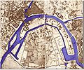
Kazakov project, 1775
Matvey Kazakov
Matvey Fyodorovich Kazakov was a Russian Neoclassical architect. Kazakov was one of the most influential Muscovite architects during the reign of Catherine II, completing numerous private residences, two royal palaces, two hospitals, Moscow University, and the Kremlin Senate...
(senior). In addition to separating Balchug Island from Zamoskvorechye, Kazakov also proposed cutting two flood control dikes west from Bersenevka. This would separate strips of floodland from the mainland, creating two more islands. In the east, Kazakov planned to flood uninhabited farmland permanently, and connect the Canal to Moskva River inside the present-day Garden Ring
Garden Ring
The Garden Ring, also known as the "B" Ring , is a circular avenue around the central Moscow, its course corresponding to what used to be the city ramparts surrounding Zemlyanoy Gorod in the 17th century....
. The eastern end of an island
Sadovnicheskaya Street
Sadovnicheskaya street is a street in the historical Zamoskvorechye District of Moscow, Russia, on a narrow island between Moskva River and the parallel old river bed . The street runs from Balchug Street south-east to the Garden Ring.-History:Historical neighborhood of Sadovniki Sadovnicheskaya...
would become Moscow's fortified grain port and warehouse. Moat east of Balchug had to be cleared and widened, too.
1783-1786 canal
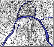
A notably devastating flood occurred in 1783, razing the suburbs and damaging Bolshoy Kamenny Bridge (three spans collapsed, killing four people). In order to repair it, Moskva River was temporarily drained, its water diverted into the old river bed. Prior to closing the main water way, old river bed was cleared and widened.Kazakov's plan materialized in 1783-1786, excluding the grain terminal. A 1807 plan shows only one "additional" island west of Bersenevka; otherwise, it follows Kazakov's project; the main island is cut into two halves by the Balchug moat.
19th century
After the Fire of 1812, the western island and the dike separating it from the mainland were reclaimed for development (today, they form the Golden MileGolden Mile
There are many geographical features called the "Golden Mile":* The Golden Mile, Belfast, Northern Ireland, United Kingdom * The Golden Mile, Blackpool, UK* The Golden Mile, Brentford, UK* The Golden Mile, Great Yarmouth, UK* The Golden Mile, Leicester, UK...
of Khamovniki District). Moskva River was reduced to about its present-day width (see the 1824 map). The eastern end of Canal was also reduced to its ordinary width of 30 metres.
In 1835, the city built Babyegorodskaya Dam west of the island. The dam was disassembled each autumn and set back in place after the spring flood, so it was good for shipping but useless against floods. A new channel extension east was built to bypass the old 90-degree turn; as the 1853 map shows, the new canal cut Red Hills neighborhood away from the mainland. For a while, the island was cut into three parts, then, when Balchug moat was filled, in two.
1930s - present day
Moscow Canal
The Moscow Canal , named the Moscow-Volga Canal until the year 1947, is a canal that connects the Moskva River with the main transportation artery of European Russia, the Volga River. It is located in Moscow itself and in the Moscow Oblast...
(1932–1938) raised the water level in Moskva river and the canal, enabling reliable shipping throughout summer seasons. Locks on the canal were demolished (this function was taken by Pererva locks downstream). The moat parallel to Garden Ring
Garden Ring
The Garden Ring, also known as the "B" Ring , is a circular avenue around the central Moscow, its course corresponding to what used to be the city ramparts surrounding Zemlyanoy Gorod in the 17th century....
was also filled in 1930s, with the completion of Bolshoy Krasnokholmsky Bridge
Bolshoy Krashokholmsky Bridge
Bolshoy Krasnokholmsky Bridge is a steel arch bridge that spans Moskva River in downtown Moscow, Russia, carrying Garden Ring between Tagansky District and Zamoskvorechye Districts. It was completed in 1938 by V.M.Vakhurkin , G.P.Golts and D.M.Sobolev...
.
The first bridges of Soviet age, Komissariatsky bridge
Bolshoy Ustinsky Bridge
Bolshoy Ustinsky Bridge is a steel arch bridge that spans Moskva River near the mouth of Yauza River, connecting the Boulevard Ring with Zamoskvorechye district in Moscow, Russia...
(1927) and pedestrian Zverev Bridge
Zverev Bridge
Zverev Bridge is a pedestrian arch bridge that spans Vodootvodny Canal in Zamoskvorechye district of downtown Moscow, Russia. It was built in 1930 by N.Ya.Kalmykov and I.A.Frantsuz ....
(1927) were built with sufficient clearance. Chugunny Bridge (1889) was also compatible with new requirements (completion of a new Bolshoy Moskvoretsky Bridge
Bolshoy Moskvoretsky Bridge
Bolshoy Moskvoretsky Bridge is a concrete arch bridge that spans the Moskva River in Moscow, Russia, immediately east of the Moscow Kremlin. The bridge connects Red Square with Bolshaya Ordynka street in Zamoskvorechye. Built in 1936-1937, it was designed by V. S...
diverted traffic away from this bridge). All other bridges were rebuilt in 1930s to 6-8 traffic lanes.
In the 1960s, Schluzovoy Bridge
Schluzovoy Bridge
Schluzovoy Bridge is a concrete cantilever bridge in Moscow, Russia, spanning the eastern extremity of Vodootvodny Canal and connecting right-bank embankments of Moskva River. Existing bridge was completed in 1965 by engineer Z.V...
construction connected the embankments on the eastern tip of the island. Chugunny Bridge steel deck was replaced with concrete. Sadovnichesky Bridge
Sadovnichesky Bridge
Sadovnichesky Bridge is a cоncrete pedestrian arch bridge that spans Vodootvodny Canal in historical Zamoskvorechye district of Moscow, Russia. The bridge connects Balchug island with Zamoskvorechye mainland. It was built in 1963, designed by Nina Bragina , V.A. Korchagin and K.P. Savelyev...
was completed in 1963; it is actually a water pipe conduit with a secondary function of a pedestrian bridge. Two more pedestrian bridges, Second Schluzovoy and Luzhkov Bridge, were added in 1990s. Construction of Patriarshy Bridge
Patriarshy Bridge
Patriarshy Bridge is a steel pedestrian arch bridge that spans Moskva River, connecting Cathedral of Christ the Saviour with Bersenevka in downtown Moscow, Russia . It was built in 2004, designed by Mikhail Posokhin...
extension over canal is currently under way.
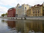
The City planners entertain plans to build a parking lot under the canal, from across Golutvin sloboda
Sloboda
Sloboda was a kind of settlement in the history of Russia, Belarus and Ukraine. The name is derived from the early Slavic word for "freedom" and may be vaguely translated as "free settlement"....
office block (see photo above), to Tretyakov Gallery
Tretyakov Gallery
The State Tretyakov Gallery is an art gallery in Moscow, Russia, the foremost depository of Russian fine art in the world.The gallery's history starts in 1856 when the Moscow merchant Pavel Mikhailovich Tretyakov acquired works by Russian artists of his day with the aim of creating a collection,...
. This would require setting up dams, temporarily drying up the canal and digging the open pit.